Report on Fourpeaked (United States) — January 2012
Bulletin of the Global Volcanism Network, vol. 37, no. 1 (January 2012)
Managing Editor: Richard Wunderman.
Edited by Robert Dennen.
Fourpeaked (United States) Syn- and post-eruptive seismicity and emissions; magma intrusion model
Please cite this report as:
Global Volcanism Program, 2012. Report on Fourpeaked (United States) (Dennen, R., and Wunderman, R., eds.). Bulletin of the Global Volcanism Network, 37:1. Smithsonian Institution. https://doi.org/10.5479/si.GVP.BGVN201201-312260
Fourpeaked
United States
58.77°N, 153.672°W; summit elev. 2105 m
All times are local (unless otherwise noted)
Following the 17 September 2006 phreatic eruption of Fourpeaked volcano and subsequent non-juvenile ash emissions and debris flows (Cervelli and West, 2007; BGVN 31:09), low level seismicity (up to M 1.8) and emissions (S02 fluxes up to almost 3,000 tons/day) continued during late 2006 and the first half of 2007. Small explosions occurred during February-April 2007 amidst declining gas emissions. The Alaska Volcano Observatory (AVO) lowered the Aviation Color Code and Volcano Alert Level from Yellow/Advisory to Green/Normal on 6 June 2007 (on a scale from Green/Normal to Red/Warning).
Seismic monitoring network. Prior to the 2006-2007 eruption and unrest, Fourpeaked lacked a monitoring network (BGVN 31:09). A network of monitoring instruments was deployed in stages following the onset of unrest in 2006 (figure 8). The network consisted of 4 short-period seismometers (3 newly-deployed and 1 pre-existing), 2 co-located pressure sensors, and a web camera. As a result of the stepwise deployment of the instruments, the precision and number of earthquakes successfully located by AVO increased during the active period. Following the network's successful operation through the winter of 2006-2007, Fourpeaked was formally recognized as the 31st seismically monitored Alaskan volcano on 3 May 2007.
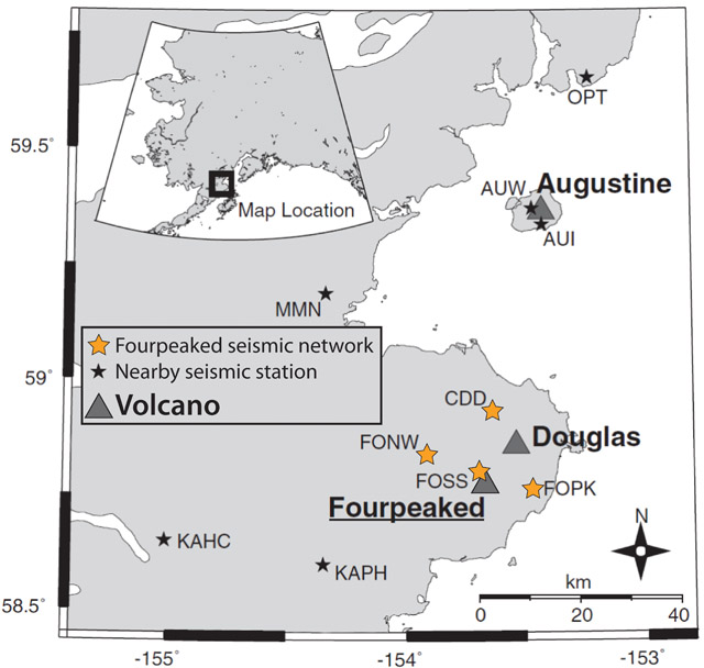 |
Figure 8. The seismic monitoring network of Fourpeaked volcano. Orange stars indicate the 4 short-period seismometers monitoring Fourpeaked; black stars indicate other nearby seismometers; triangles indicate volcanoes. Modified from Gardine and others (2011). |
November 2006-June 2007 activity. AVO reported that low level seismicity and persistent steaming (reaching up to several hundred meters above the summit) continued through the end of 2006. McGimsey and others (2011) reported that an airborne gas survey on 6 November 2006 showed continued elevated S02 emissions (~1,000 tons/day). The measured S02 flux measured soon after the 17 September eruption (figure 9) was more than 2,000 tons/day (McGimsey and others, 2011). In January 2007, AVO reported an earthquake swarm (swarm IV, figure 9), but stated that it was not considered unusual. Until 8 February, activity was typical of the past few months.
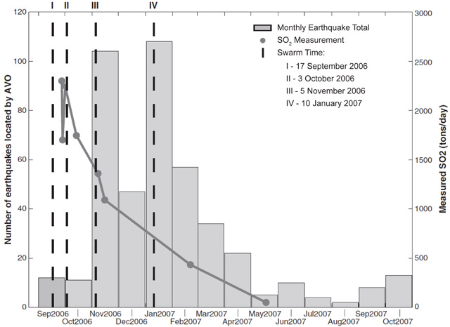 |
Figure 9. Recorded syn- and post-eruptive seismicity and S02 emissions at Fourpeaked volcano. Plots indicate the number of earthquakes per month (gray bars), timing of earthquake swarms (I-IV, vertical dashed black lines), and measured S02 emissions (tons/day, dark gray points and trend). The data extend 13 months following the 17 September 2006 phreatic eruption (swarm I). Courtesy of Gardine and others (2011). |
Beginning on 8 February 2007, AVO reported small explosive events that were registered on seismic and acoustic instruments, and a possible large steam plume that was noticed in a partly cloudy satellite view. A swarm of 13 locatable earthquakes occurred on 18 February, the largest of which was an M 1.8 event at ~4 km deep; this was the largest seismic event of the 2006-2007 Fourpeaked activity (McGimsey and others, 2011). A gas overflight on 22 February recorded S02 flux values below those measured in November.
Occasional small eruptions continued through March 2007, while seismicity gradually decreased (McGimsey and others 2011). In the last week of March, AVO reported decreased steam emissions from the vents at the summit. Explosive activity and declining gas emissions continued throughout April, and on 18 May, an aerial gas measurement revealed that the S02 flux had decreased to less than 90% of the measured values in September 2006 (Cervelli and West, 2007).
On 6 June 2007, citing declining seismicity and gas emissions, AVO lowered the Aviation Color Code from Yellow to Green, and the Volcanic Activity Alert Level from Advisory to Normal. They noted that "local hazards still [existed] near the summit, including jetting steam and/or very small explosions, unstable snow and ice, hot water and rock, and the possibility for high concentrations of dangerous volcanic gas."
Magma intrusion. Gardine and others (2011) analyzed seismic and gas emission data from the 2006-2007 Fourpeaked eruption and unrest (figure 9) in order to constrain the origin of the eruptive activity. Their findings suggested that the high levels of seismicity and gas emissions during the initial unrest indicated the intrusion of new magma into the upper 10 km of crust. They suggested that the intrusion reactivated fractures, allowing gases exsolved from the magma to be released at the surface. They argued that continued exsolution provided the gases released during the period of unrest, while local stress accumulation led to earthquake swarms (figure 9). They also suggested that the activity ceased only after the magma had cooled and degassed to a point where it became trapped and could no longer overcome the overburden pressure.
References. Cervelli, P.F. and West, M., 2007, The 2006 Eruption of Fourpeaked Volcano, Katmai National Park, Alaska, American Geophysical Union, Fall Meeting 2007, abstract ##V31E-0719.
Gardine, M., West, M., Werner, C., and Doukas, M., 2011, Evidence of magma intrusion at Fourpeaked volcano, Alaska in 2006-2007 from a rapid-response seismic network and volcanic gases, Journal of Volcanology and Geothermal Research, v. 200, issues 3-4, p. 192-200 (DOI: 10.1016/j.jvolgeores.2010.11.018).
McGimsey, R.G., Neal, C.A., Dixon, J.P., Malik, N., and Chibisova, M., 2011, 2007 Volcanic Activity in Alaska, Kamchatka, and the Kurile Islands: Summary of Events and Response of the Alaska Volcano Observatory, US Geological Society Scientific Investigations Report 2010-5242, 103 p.
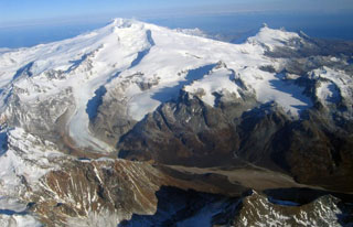
Geological Summary. Poorly known Fourpeaked volcano in NE Katmai National Park consists of isolated outcrops surrounded by the Fourpeaked Glacier, which descends eastward almost to the Shelikof Strait. The orientation of andesitic lava flows and extensive hydrothermal alteration of rocks near the present summit suggest that it probably marks the vent area. Eruptive activity during the Holocene had not been confirmed prior to the first historical eruption in September 2006. A N-trending fissure extending 1 km from the summit produced minor ashfall.
Information Contacts: Alaska Volcano Observatory (AVO), a cooperative program of a) U.S. Geological Survey (USGS), 4200 University Drive, Anchorage, AK 99508-4667 USA (URL: http://www.avo.alaska.edu/), b) Geophysical Institute, University of Alaska, PO Box 757320, Fairbanks, AK 99775-7320, USA, and c) Alaska Division of Geological & Geophysical Surveys (ADGGS), 794 University Ave., Suite 200, Fairbanks, AK 99709, USA (URL: http://www.dggs.alaska.gov/).