Report on Mombacho (Nicaragua) — February 2012
Bulletin of the Global Volcanism Network, vol. 37, no. 2 (February 2012)
Managing Editor: Richard Wunderman.
Edited by Julie A. Herrick.
Mombacho (Nicaragua) Seismicity and fumarole characteristics from 2000 to 2011
Please cite this report as:
Global Volcanism Program, 2012. Report on Mombacho (Nicaragua) (Herrick, J.A., and Wunderman, R., eds.). Bulletin of the Global Volcanism Network, 37:2. Smithsonian Institution. https://doi.org/10.5479/si.GVP.BGVN201202-344110
Mombacho
Nicaragua
11.826°N, 85.968°W; summit elev. 1344 m
All times are local (unless otherwise noted)
Our BGVN reports discussing Mombacho volcano have discussed variable fumarolic gas emissions and characteristics of hot springs since 1980. Data collection from three distinct fumaroles became available by the Instituto Nicaragüense de Estudios Territoriales (INETER) starting in 1994 (BGVN 19:11). Since January 2000, the Geophysics Department of INETER has published "Sismos y Volcanes de Nicaragua," a monthly bulletin for volcanoes throughout Nicaragua. Status and seismicity reports for Mombacho appear as early as December 2000. Here we present a summary of field observations including local seismicity from 2000 to 2010, and thermal measurements from Mombacho's fumaroles from July 2001 to December 2011.
Local seismicity from 2000 through 2010. INETER reported a significant number of earthquake magnitudes and hypocenter locations in 2000 (table 1). A total of 14 events were registered and located during July-October. Few earthquakes were registered after 2000, with the largest magnitudes being ML 2.6-2.7. One seismic station with a radio repeater is located on Mombacho's flanks ~1.5 km to the NW of the summit.
Table 1. Located earthquakes recorded near Mombacho from 2000 through 2010. For each year, the table lists the number of located earthquakes, the range of their local magnitudes (ML), the range of their focal depths, and the average focal depths. Courtesy of INETER.
| Year | Earthquakes | ML | Range of focal depths (km) | Average focal depths (km) |
| 2000 | 14 | 2.1-2.9 | 0-6 | 2.9 |
| 2002 | 4 | 2.3-2.7 | 2-14 | 6 |
| 2004 | 2 | 2.5-2.6 | 4-18 | 11 |
| 2010 | 1 | 2.7 | 70 | 70 |
Fumarole temperature monitoring from 2001 to 2011. There are three well-established fumarole areas near the summit of Mombacho located above 800 m asl (figure 1 in BGVN 19:11). Fumarole temperatures were collected intermittently between July 2001 and December 2011 (table 2). Depending on surface conditions (local rockfalls often covered fumaroles), one to five different point sources were visited during this time period. Temperatures had a wide range and were frequently low; the lowest temperatures were recorded in November 2009 (81°C), March 2011 (61.5°C), and June 2011 (81°C). Temperatures greater than 125°C were rare; the highest measurements of 398°C were measured in August 2009, August 2010, and December 2011. INETER made numerous visits to Mombacho's fumarole fields from 2000 to 2011 however, it wasn't always possible to take measurements. Campaigns to fumarole sites were encumbered by dense vegetation; new trails needed to be cut for each visit, even with a time lapse as small as three months during the dry season. Temperatures were measured at fumaroles with a digital thermometer. INETER observed that landslides frequently covered fumarole sites and reported the extent of debris in their field reports: 19 August 2009, 14 May 2010, July 2010, 19 August 2010, 15 June 2011, 12 December 2011.
Table 2. Fumarole temperature data collected during campaigns to Mombacho sites from 2001 to 2011. Temperatures were measured with a handheld digital thermometer. Courtesy of INETER.
| Month | Temp. Range °C |
| Jul 2001 | 100-110 |
| Feb 2002 | 100-120 |
| Apr 2003 | 96.5-120.6 |
| Jul 2003 | 96.5-121.0 |
| Apr 2005 | 98.4-110.5 |
| Aug 2007 | 95.3-123 |
| Nov 2008 | 96.1-125 |
| Aug 2009 | 92-398 |
| Nov 2009 | 81-94 |
| Feb 2010 | 90-99 |
| May 2010 | 99-117 |
| Jul 2010 | 90-112 |
| Aug 2010 | 92-398 |
| Nov 2010 | 90-93 |
| Mar 2011 | 61.5 |
| Jun 2011 | 81-86 |
| Dec 2011 | 96-302 |
Field observations. Field visits from December 2000 to December 2011 by INETER consistently encountered the effects of landslides within Mombacho's southern crater. The steep walls, especially the E and W scarps, shed debris that collected within the crater. Evidence of large rockfalls was typically encountered after major rain events such as Hurricane Keith in September 2000 and a tropical storm in October 2010.
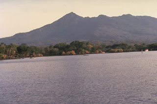
The southern crater is one of two dramatic collapse amphitheaters (figure 2). The collapse scars show up as high relief features in satellite imagery and topographic maps. At least three large-volume debris avalanche deposits have been attributed to Mombacho and resulted from catastrophic flank collapse (Shea and others, 2008). The long runout of the northern deposit reached Lake Nicaragua and formed the arcuate peninsula and cluster of islands, Isletas de Granada, ~11 km NE from Mombacho's summit (close-up photos and captions are available in the GVP Photo Archive).
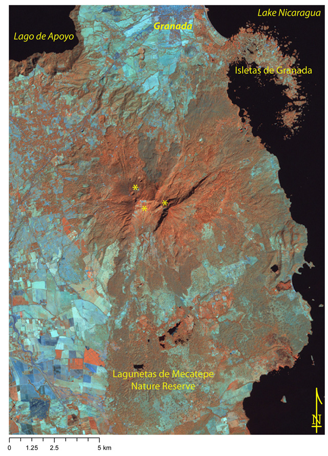 |
Figure 2. Satellite image centered on Mombacho using near-, mid-infrared, and infrared bands (Landsat bands 4,5,7). Recent rockfalls and water-poor soils appear cyan; brown-to-red areas indicate moist soils; water is black. Small ponds (irregular black shapes) are found within the Lagunetas de Mecatepe Reserve in an area mapped as debris avalanche deposits (Shea and others, 2008). Three yellow asterisks mark fumarole areas near the summit and local place names note major landmarks in the area including the city of Granada (N of the summit). The three circular features (~400 m diameter) located SW of the city of Granada, are the Granada Fissure Vents, sometimes called the La Joya alignment. Landsat acquired this ETM+ image on 27 January 2000 and it was processed by GVP (NASA Landsat Program, 2003). |
Several investigations into the debris avalanche deposits of Mombacho revealed new ideas about the likely factors that led to flank failure. The geologic setting of Mombacho includes the extensive pumice-rich ignimbrite deposits from Apoyo and Las Sierras and potentially lake sediments from Lake Nicaragua (figure 3). These relatively weak units that underlie Mombacho's edifice may have promoted gravitational spreading if the weight of the volcanic edifice caused deformation of the substratum. The near-vertical southern scarp exposes hydrothermally altered rock. This clay-rich material could have contributed to the weakening process that triggered the S-directed collapse. Deposits linked to the S-facing scarp have been mapped to the southernmost edge of the Lagunetas de Mecatepe Nature Reserve (~12 km from the summit).
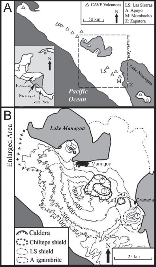 |
Figure 3. (A) The top figure is centered on the W coast of Nicaragua where major Quaternary volcanoes are aligned in the Central American Volcanic Front (CAVF). Mombacho (M) is located on the shore of Lake Nicaragua, within the enlarged area of this map, as well as other major sites: Las Sierras (LS), Apoyo (A), and Zapatera (Z). (B) Starting in the NW, the numbers correspond to major volcanic sites: 1 Chiltepe shield (Apoyeque and Jiloa Calderas), 2 Las Sierras caldera complex, 3 Masaya caldera complex, 4 Apoyo caldera, and 5 Mombacho volcano. This composite image is modified from Shea and others (2008) and van Wyk de Vries (1993). |
References. NASA Landsat Program (2003) Landsat ETM+ scene 7dt20000127, SLC-Off, USGS, Sioux Falls, Jan. 27, 2000.
Shea, T., van Wyk de Vries, B., and Pilato, M. (2008) Emplacement mechanisms of contrasting debris avalanches at Volcan Mombacho (Nicaragua), provided by structural and facies analysis. Bulletin of Volcanology, v. 70, p. 899-921.
van Wyk de Vries, B. (1993) Tectonics and magma evolution of Nicaraguan volcanic systems. [PhD thesis] Milton Keynes, The Open University, UK.
Geological Summary. Mombacho is an andesitic and basaltic stratovolcano on the shores of Lake Nicaragua south of the city of Granada that has undergone edifice collapse on several occasions. Two large breached craters formed by edifice failure cut the summit on the NE and S flanks. The NE-flank scarp was the source of a large debris avalanche that produced an arcuate peninsula and a cluster of small islands (Las Isletas) in Lake Nicaragua. Two small, well-preserved cinder cones are located on the lower N flank. The only reported activity was in 1570, when a debris avalanche destroyed a village on the south side of the volcano. Although there were contemporary reports of an explosion, there is no direct evidence that the avalanche was accompanied by an eruption. Fumarolic fields and hot springs are found within the two collapse scarps and on the upper N flank.
Information Contacts: Instituto Nicaragüense de Estudios Territoriales (INETER), Apartado Postal 2110, Managua, Nicaragua (URL: http://www.ineter.gob.ni/); Global Land Cover Facility (URL: http://http://www.glcf.umiacs.umd.edu/); Washington Volcanic Ash Advisory Center (VAAC), Satellite Analysis Branch (SAB), NOAA/NESDIS E/SP23, NOAA Science Center Room 401, 5200 Auth Rd, Camp Springs, MD 20746, USA (URL: http://www.ospo.noaa.gov/Products/atmosphere/vaac/).