Report on Kelud (Indonesia) — March 2012
Bulletin of the Global Volcanism Network, vol. 37, no. 3 (March 2012)
Managing Editor: Richard Wunderman.
Kelud (Indonesia) Amid quiet, a look back at aspects of the 2007 eruption
Please cite this report as:
Global Volcanism Program, 2012. Report on Kelud (Indonesia) (Wunderman, R., ed.). Bulletin of the Global Volcanism Network, 37:3. Smithsonian Institution. https://doi.org/10.5479/si.GVP.BGVN201203-263280
Kelud
Indonesia
7.935°S, 112.314°E; summit elev. 1730 m
All times are local (unless otherwise noted)
A memorable eruption at Kelut began in August 2007 injecting what became a substantial lava dome in the midst of a crater lake. The process was devoid of large violent steam explosions of the kind often associated with molten lava extruding into a lake. The passively emplaced lava dome evaporated and displaced most or all of the crater lake. Dome extrusion had clearly stopped by April 2008 (BGVN 33:07) or perhaps by May 2008 (De Bélizal and others, 2012). Since then and as late as April 2012, the Center of Volcanology and Geological Hazard Mitigation (CVGHM), has noted ongoing quiet, at times broken by the emergence of diffuse white plumes. Those plume were seen in June 2009 rising 50-150 m above the crater and the new dome was still emitting steam in February 2012. As of 30 March 2012, the Alert Level remained Green, although CVGHM recommended that people not approach the lava dome due to instability of the area and the presence of potentially high temperatures and poisonous gases.
Three short subsections follow. The first discusses uplift at Kelut during 2007-2008 as part of a larger survey of volcanic deformation on Java (Philibosian and Simons, 2011). The next subsection discusses a paper that provides an overview on the unexpectedly tranquil eruption, which, though of substantial size, was one of Kelut's few substantial yet passive eruptions in the historic record (De Bélizal and others, 2012). The authors surveyed residents to assess how they felt about how authorities had managed the crisis. The third subsection below discusses the dome's declining thermal output in early 2008, and presents a photo taken in February 2011 showing the steaming dome's spiny upper surface.
2007-2008 deformation. Philibosian and Simons (2011) discussed satellite-borne (Japanese ALOS) L-band synthetic aperture radar used to conduct a comprehensive survey of volcanic deformation on Java during 2007-2008. For Kelut, the authors found a possible 15 cm line-of-sight change in late 2008, an uplift. The area of uplift was limited to the very top of Kelut and was only a few hundred meters wide. However, the authors state that, given there were only two radar acquisitions after this late 2008 uplift, it was "difficult to judge whether this was permanent, real deformation rather than a short-term atmospheric effect." According to the authors, "the volcano did not exhibit a significant deformation before or during the dome extrusion in our time series" (figure 13).
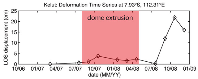 |
Figure 13. Time series of Kelut's deformation during October 2006-January 2009 (summing all the time steps and for satellite track 428). The plot shows the 15-cm line-of-sight change consistent with an uplift peaking during late 2008. The period of observed lava dome extrusion (shown in red) corresponded with a minor uplift (under 5 cm along the line of sight). Taken from Philibosian and Simons (2011). |
2007 eruption and crisis management revisited. De Bélizal and others (2012) discuss a survey conducted shortly after the end of an evacuation process triggered by Kelut's eruption that started in 2007.
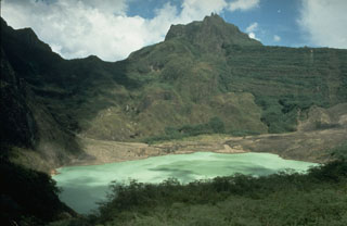
The authors summarized Kelut's unrest that started prior to the extrusions first seen in August by noting that earlier, on 1 November 2007, CVGHM recorded a new peak of seismicity with signals having reached shallow depths beneath the crater floor. The crater lake temperature recorded by a thermal camera increased significantly by 6 November. A steam plume developed, reaching 550 m above the crater lake. A new lava dome extruded through the ~350 m diameter crater lake (BGVN 33:03). Progressively, nearly all the lake water vaporized as the lava dome grew to a diameter of 400 m and a height of 260 m representing a volume of ~35 x 106 m3.
According to De Bélizal and others (2012), "recorded volcanic seismicity decreased shortly after the onset of dome growth. Tiltmeter records also showed the absence of any significant deformation on the flanks of the volcano. These data suggested that the magmatic pressure decreased within the volcano therefore greatly reducing the likelihood of a violent explosion. Thus, on 8 November 2007, Indonesian authorities decided to end the emergency phase. The volcano Alert Level was lowered to Level 3 'Siaga' until 30 November, when it was then lowered to Level 2 'Waspada' until August 2008."
The passively extrusive and unexpectedly non-explosive eruption was the first here in recent historical times. This called for careful monitoring of both the eruptive behavior of the volcano and the stability of a lake-bound dome plugging the vent. Tourism and agriculture ceased on its flanks for many months in anticipation of potential sudden signs of renewed activity.
The article stated that the crisis management team ordered an evacuation, which followed the rise to Alert Level 4 on 16 October 2007 (BGVN 33:03), but it noted that many residents disregarded the order because they did not consider that an eruption was imminent. The authors conducted interviews with members of the crisis management team, and undertook a questionnaire-based survey in the settlement nearest to the crater to determine how residents reacted to the crisis and how they thought authorities managed the crisis. The survey was carried out while Kelut was still under surveillance for fear of an explosive phase. According to the authors, the crisis management team "was well organized and strategic"; however, the results "showed that crisis management was not fully integrated with the way of life of the local communities at risk, and that information, communication and trust were lacking."
Decreasing thermal alerts in 2008 and an early 2011 photo. During November and December 2007, there were numerous days with MODVOLC thermal alerts. This number decreased in January 2008 to only six days that month. After January 2008, thermal alerts had been absent as late as 27 April 2012. The probable cause was the cooling of the dome to the point where the levels of thermal radiation emitted dropped below the threshold values needed to create MODVOLC alerts.
A photo of Kelut taken by Daniel Quinn in early 2011 shows the steaming, rough-surfaced lava dome in the crater (figure 14). The photo only showed a small portion of the entire crater floor, but on the N side of the dome, the crater floor contained a dark brown, muddy-colored patch of water the photographer considered a large puddle. Some 2010 photos on the Picassa website showed a small body of water on the crater floor at that time.
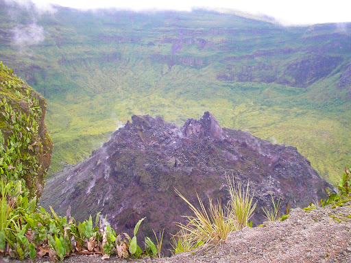 |
Figure 14. A late January or early February 2011 photo taken of Kelut's new dome from a high spot on the NNW rim. Apparent are both the dome's spiny upper surface, and many areas of the dome still emitting small amounts of steam. The photo appeared on the Picassa website and is used with the permission of the photographer, Daniel Quinn. |
According to Daniel Quinn, the photo in figure 14 was taken on the rim at a spot accessed via a small pavilion he passed walking from the car parking area. He took the photo having walked clockwise about as far around the rim as he could travel before reaching vertical cliffs. Pungent odors were absent during his visit.
References. De Bélizal, É., Lavigne, F., Gaillard, J., Grancher, D., Pratomo, I., and Komorowski, J. , 2012. The 2007 eruption of Kelut volcano (East Java, Indonesia): Phenomenology, crisis management and social response, Geomorphology, v. 136, issue 1, p. 165-175.
Philibosian, B., and Simons, M., 2011. A survey of volcanic deformation on Java using ALOS PALSAR interferometric time series, Geochemistry Geophysics Geosystems, v. 12, no. 11, 8 November 2011, Q11004, 20 pp. (DOI:10.1029/2011GC003775).
Geological Summary. The relatively inconspicuous Kelud stratovolcano contains a summit crater lake that has been the source of some of Indonesia's most deadly eruptions. A cluster of summit lava domes cut by numerous craters has given the summit a very irregular profile. Satellitic cones and lava domes are also located low on the E, W, and SSW flanks. Eruptive activity has in general migrated in a clockwise direction around the summit vent complex. More than 30 eruptions have been recorded since 1000 CE. The ejection of water from the crater lake during the typically short but violent eruptions has created pyroclastic flows and lahars that have caused widespread fatalities and destruction. After more than 5,000 people were killed during an eruption in 1919, an engineering project to drain the crater lake lowered the surface by more than 50 m. The 1951 eruption deepened the crater by 70 m, leaving 50 million cubic meters of water after the damaged drainage tunnels were repaired. Following more than 200 deaths in the 1966 eruption, a new deeper tunnel was constructed, and the lake's volume before the 1990 eruption was only about 1 million cubic meters.
Information Contacts: Center of Volcanology and Geological Hazard Mitigation (CVGHM), Jalan Diponegoro 57, Bandung 40122, Indonesia (URL: http://vsi.esdm.go.id/); Daniel P. Quinn (URL: http://bubbingtondump.com/).