Report on Puyehue-Cordon Caulle (Chile) — March 2012
Bulletin of the Global Volcanism Network, vol. 37, no. 3 (March 2012)
Managing Editor: Richard Wunderman.
Edited by Robert Dennen.
Puyehue-Cordon Caulle (Chile) June 2011 eruption emits circum-global ash clouds
Please cite this report as:
Global Volcanism Program, 2012. Report on Puyehue-Cordon Caulle (Chile) (Dennen, R., and Wunderman, R., eds.). Bulletin of the Global Volcanism Network, 37:3. Smithsonian Institution. https://doi.org/10.5479/si.GVP.BGVN201203-357150
Puyehue-Cordon Caulle
Chile
40.59°S, 72.117°W; summit elev. 2236 m
All times are local (unless otherwise noted)
Until 4 June 2011, the volcanic complex named Puyehue-Cordón Caulle had been quiet since its last major eruption in 1960. This report summarizes an increase in seismicity in early 2011 and the ensuing eruption that began on 4 June 2011. Our previous and only reports on the complex were in March and April 1972, which offered and then dismissed a report of a 1972 eruption (CSLP Cards 1362 and 1371). Information here goes through 2011 but omits some remote sensing observations. The eruption continued through at least April 2012, but in March and again in April 2012 the eruption's diminished vigor resulted in successively lowered alert statuses. During the height of the eruption the vent emitted ash plumes and generated significant ashfall, and flights were cancelled as far away as Australia and New Zealand. Pyroclastic flows occurred, with runout distances up to 10 km.
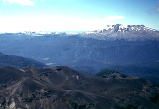
The Puyehue-Cordón Caulle complex includes Puyehue volcano at the SE end and the Cordillera Nevada caldera at the NW end. The current eruption discussed here vented at a location roughly between these two features, along the same fissure complex that had been active in the 1960 eruption. Available information failed to disclose any other eruptive sites during the reporting interval. Although the eruption continues as this report goes to press in March 2012, the report discusses activity only during 2011. A subsequent report will discuss further details, including satellite data on eruptive plumes, and updates since the end of the 2011 reporting period. This report also contains a table that condenses reporting from the Buenos Aires Volcanic Ash Advisory Center (VAAC).
Precursory seismicity. The Southern Andes Volcanological Observatory-National Geology and Mining Service (SERNAGEOMIN) reported that on 26 April 2011 an overflight of the volcano was conducted in response to recent increased seismicity and observations of fumarolic activity by nearby residents. Scientists confirmed fumarolic activity, but did not observe any other unusual activity.
On 27 April a seismic swarm (with about 140 events under ML 3.0) was detected at depths of 4-6 km below the complex. Most were hybrid earthquakes, the largest being M 3.9. Lower levels of seismicity continued through 29 April. That day the Alert Level was raised to Yellow (on a scale from Green to Yellow to Red).
According to SERNAGEOMIN, between 2000 on 2 June and 1959 on 3 June 2011, about 1,450 earthquakes occurred at Puyehue-Cordón Caulle (~60 earthquakes/hour, on average). More than 130 earthquakes occurred with magnitudes greater than 2.0. The earthquakes were mostly hybrid and long-period, and located in the SE sector of the Cordón Caulle rift zone at depths of 2-5 km. A flight over the volcano revelaed no significant changes. Area residents reported feeling earthquakes during the evening of 3 June through the morning of 4 June.
For a six-hour period on 4 June, seismicity increased to an average of 230 earthquakes/hour, with hypocenter depths of 1-4 km. About 12 events were of magnitudes greater than 4.0, and 50 events were of magnitudes greater than 3.0. As a result of the increased seismicity, the Alert Level was raised from Yellow to Red on 4 June.
Eruption. On 4 June 2011, an explosion from Cordón Caulle produced a set of plumes, including an ash plume described as 5 km wide and with its top at ~12 km altitude. Portions of the plume bifurcated; at ~5 km altitude a part of the plume drifted S, and at ~10 km altitude parts drifted W and E. A news account (Agency France-Presse) around this time, quoting a government official, said the eruption would lead to the evacuation of 4,270 residents.
According to the Oficina Nacional de Emergencia-Ministerio del Interior (ONEMI), SERNAGEOMIN had noted the presence of pyroclastic flow deposits, but not lava. Residents reported a strong sulfur odor and significant ash and pumice fall. According to the BBC, the number of evacuees rose to 3,500-4,000 during the next several days.
According to SERNAGEOMIN, the eruption from the Cordón Caulle rift zone, although somewhat diminished, continued on 5 June. At least five pyroclastic flows were generated from partial collapses of the eruptive column and traveled N in the Nilahue River drainage. These pyroclastic flows extended up to 10 km from the vent.
Figures 1-3 show scenes of the volcano from various perspectives, including a natural color January 2012 image from space.
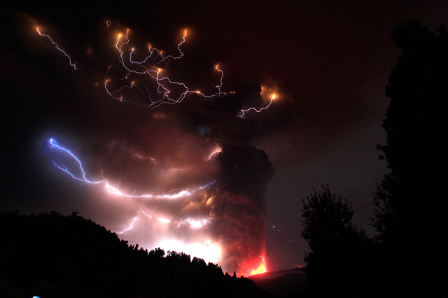 |
Figure 1. Puyehue-Cordón Caulle's eruption seen in a long-exposure photo taken during 4-6 June 2011. The photo depicts molten material discharging over a wide area near the eruption column's base. Above the glowing, molten material there grew a substantial, rapidly rising ash plume. Much of the scene is lit by numerous bolts of lightning. Courtesy of Daniel Basualto, European Pressphoto Agency. |
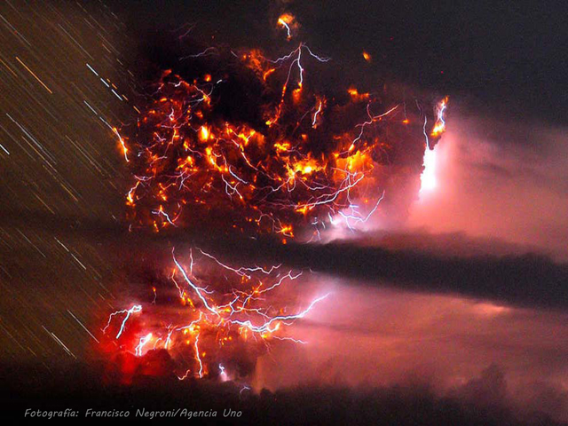 |
Figure 2. A long-exposure photograph of the eruption at the Puyehue-Cordón Caulle complex taken on 5 June 2011. The complex scene shows a wide eruption column aglow with prominent lightning strikes branching across its surface. The long exposure is evidenced by the long star trails (with stars forming streaks due to the Earth's rotation) and the superimposition of many distinct bolts of lightning. Courtesy of Franscisco Negroni, Agencia Uno/European Pressphoto Agency. |
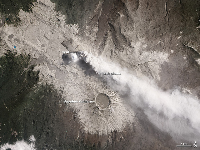 |
Figure 3. Satellite photo acquired on 26 January 2012 of the Puyehue-Cordón Caulle area. The natural color image was taken by the Advanced Land Imager aboard the Earth Observing (EO-1) satellite. The emissions, which blow in a narrow band toward the SE, can clearly be observed emanating from the Cordón Caulle fissure complex and not from the Puyehue volcano itself. According to a NASA Earth Observatory report, after 8 months of ceaseless activity, the landscape around the Puyehue-Cordón Caulle complex was covered in ash. The light-colored ash appears most clearly on the rocky, alpine slopes surrounding the active vent and the Puyehue caldera. Within the caldera, the ash appears slightly darker, possibly because it may be resting on wet snow that is melting and ponding during the South American summer. NASA also noted that evergreen forests on the E side of the volcano complex have been damaged by months of nearly continuous ashfall, and are now an unhealthy brown, while forests to the W had only received intermittent coatings of ash and appeared relatively healthy. Courtesy of NASA (Robert Simmon, Mike Carlowicz, and Jesse Allen). |
Eruptive plumes were dense, oftentimes continuous, and extended E over Argentina and then the Atlantic Ocean (table 1). Ashfall reached up to about 15 cm thick in Argentina and adjacent parts of Chile (figures 4-6). Numerous flights were cancelled as far away as Australia and New Zealand, and many airports were forced to close temporarily (see section below).
Table 1. The Puyehue-Cordón Caulle ash plume altitudes and drift distances and directions documented by aviation authorities between 4 June 2011 and 3 January 2012. A plume on any particular date may be a continuation of a plume on the previous day(s). All maximum plume heights are stated in altitudes (a.s.l.). '-' indicates data not reported. Cloud cover often prevented video camera and satellite observations. Data from the Buenos Aires Volcanic Ash Advisory Center (VAAC) and SERNAGEOMIN.
| Date (2011) | Max. plume altitude (km) | Plume drift | Remarks |
| 04 Jun | 10.7-13.7 | 870 km ESE | 5-km-wide ash-and-gas plume. |
| 05 Jun | 10.7-12.2 | 1,778 km ESE | Plume drifted over Atlantic Ocean toward Australia. |
| 06 Jun | -- | 178 km ENE | -- |
| 07 Jun | 5.5-9.8 | E | Continuous emission, plume 65-95 km wide; large ash cloud drifted E over Atlantic Ocean. |
| 08 Jun | 10 | 1,200 km NE, SE | Plume moved over Atlantic Ocean. |
| 09 Jun | -- | 200 km ENE | Cloud cover obscured view. |
| 10 Jun | 6 | SE | Cloud cover obscured view. |
| 11 Jun | 6-10 | 350 km E, 600 km ENE | Explosion caused plume to rise to 10 km a.s.l. |
| 12 Jun | 10 | 300 km E, 1,000 km ENE | Series of explosions, tremor lasted 2 hr, 20 min; 4 hybrid earthquakes. |
| 13 Jun | 11 | 250 km SE | Incandescence, tremor. |
| 14 Jun | 5.5-7.6 | -- | Explosions generated pyroclastic flows. |
| 15 Jun-21 Jun | 4-8 | 1,400 km ESE | Small explosions on 15 June, ashfall heavy, pulses of tremor. |
| 22 Jun-28 Jun | 4-6 | 1,450 km NNW, 200-900 km various | Active lava flow. |
| 29 Jun-05 Jul | 4-6 | 200-900 km NW, N, E | Active lava flow. |
| 06 Jul-12 Jul | 3-4 | 75 km NE | Explosions on 7-8 Jul caused windows to vibrate in Riñinahue. |
| 13 Jul-19 Jul | 4-7 | 80-240 km E, 150 km NW | Incandescence on 18 July. Active lava flow. |
| 20 Jul-26 Jul | 3-5 | 100-250 km E, SE, 80 km E | Incandescence on 20 Jul. Active lava flow. |
| 27 Jul-02 Aug | 4-7 | 100-200 km SE, 80-400 km various | Incandescence on 26 and 29-30 Jul. Active lava flow. |
| 03 Aug-09 Aug | 4-5 | 100-700 km SE, 1,000 km NE | -- |
| 10 Aug-16 Aug | 4 | 100-150 km E, SE | Mostly white plumes. |
| 17 Aug-23 Aug | 4-6 | 200-270 km NW, 500 km NW, SE | Two explosions, harmonic tremor for 25 minutes; incandescence on 18-19 Aug. |
| 24 Aug-30 Aug | 3 | -- | Four explosions; ashfall in Temuco. |
| 31 Aug-06 Sep | 3 | 30-80 km SE, E | -- |
| 07 Sep-13 Sep | 3-6 | 10-60 km NE, E, SE | -- |
| 14 Sep-20 Sep | 5-6 | 60 km E, 40-70 km N, NW | -- |
| 21 Sep-27 Sep | 5-7 | 30-300 km various | -- |
| 28 Sep-04 Oct | 6 | 30-300 km various | -- |
| 05 Oct-11 Oct | 6 | 30-60 km various | -- |
| 12 Oct-18 Oct | 5-7 | 30-200 km various | -- |
| 19 Oct-25 Oct | 4-10 | 50-250 km various | Explosion and incandescence on 22 Oct; lava flows reported on previous days. |
| 26 Oct-01 Nov | 7-10 | 30-350 km various | Small incandescent explosions on 28-31 Oct. |
| 02 Nov-08 Nov | 4-7 | 30-120 km various | -- |
| 09 Nov-15 Nov | 6-9 | 90-250 km NE, 200 km NW, 400 km SE | Small explosions and incandescence; ashfall on Chile/Argentine border. |
| 16 Nov-22 Nov | 5-6 | 250 km SE, 100 km SW | Incandescence on 20 Nov. |
| 23 Nov-29 Nov | 5-6 | -- | Ash plume reached Atlantic Ocean. |
| 30 Nov-06 Dec | 4-5 | 90-100 km various | Incandescence. |
| 07 Dec-13 Dec | 5-6 | 90 km SE, 250 km ENE | Ashfall to E. |
| 14 Dec-20 Dec | 5 | 30-270 km SE, S, NE | -- |
| 21 Dec-27 Dec | 3-7 | 20-250 km various | Small incandescent explosions. |
| 28 Dec-03 Jan 2012 | 3-7 | 20-260 km various | Small incandescent explosions; ash fell up to 580 km SE, in Argentina. |
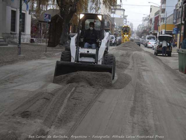 |
Figure 4. Photograph published on 6 June 2011 of workers using earth-moving equipment to remove the ash that fell 100 km SE of the Puyehue-Cordón Caulle in San Carlos de Bariloche, Argentina. As discussed in a subsection below, the ash led to the cancellation of numerous public activities, and flights were suspended. Courtesy of Alfredo Leiva, Associated Press. |
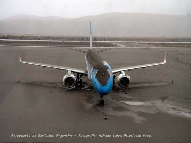 |
Figure 5. Photograph of an Air Austral jet stranded at the airport at San Carlos de Beriloche, Argentina, on 7 June 2011 after being covered with ash that blew over the Andes from the Puyehue-Cordón Caulle complex. Courtesy of Alfredo Leiva, Associated Press. |
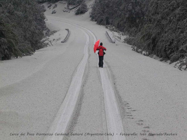 |
Figure 6. A member of the media walks along a road covered with ash from the Puyehue-Cordón Caulle complex that crossed Cardenal Samoré pass, a major linkage along the border between Argentina and Chile. Courtesy of Ivan Alvarado, Reuters. |
According to news accounts (BBC, MailOnline, Merco Press), the Nilahue river, which runs off the N slopes of the volcano, became clogged with ash and overflowed its banks. The press reports said that the river water was steaming, having been locally heated up to 45°C by hot volcanic material, and more than four million salmon and other fish died.
During 4-5 June, ashfall several centimeters thick was reported in San Carlos de Bariloche, Argentina (about 100 km SE of the volcano) and in surrounding areas (figures 4-6). ONEMI reported that the Cardenal Samoré mountain pass border crossing between Argentina and Chile had temporarily closed on 4 June due to poor visibility caused by the heavy ashfall. According to a press report (EMOL), the road crossing the border was covered with ash that locally reached 10-15 cm thick. According to MailOnline and Boston.com, ash covered Lake Nahuel Huapi, Argentina's largest lake, which lies in the eastern foothills of the Andes. Videos documenting the eruption are abundant on the YouTube website (a search there using "Puyehue volcano" brings up over 400 hits. See several examples in the Reference list below).
By 9 June 2011, pumice and vitreous tephra had accumulated in many area lakes and rivers, darkening the color or their waters (figure 7).
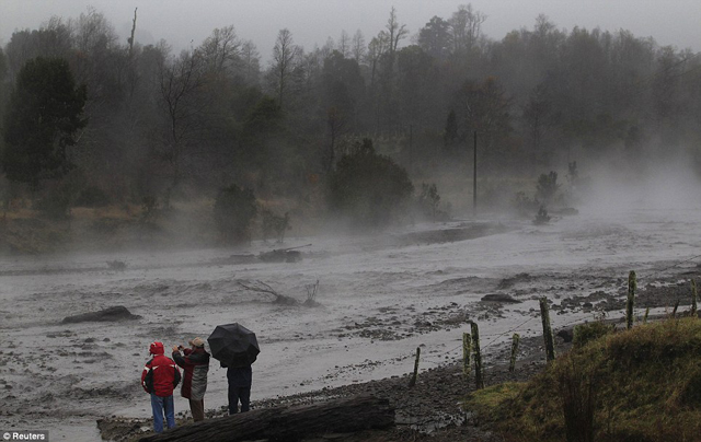 |
Figure 7. Photo of ash-clogged Nilahue River (Chile) with steam hanging above the river. Courtesy of Reuters. |
A government observation flight on 11 June revealed that the vent was located at the head of the Nilahue River's basin, a spot immediately N of the 1960 eruption fissure. Observers found that abundant amounts of ash had accumulated around the vent, as well as to the E and SW.
Scientists aboard an observation flight on 13 June reported that the eruption formed a cone located in the center of a crater ~300 to ~400 m in diameter. Gas-and-steam plumes rose from two or three locations along the same fissure as the eruptive vent. Scientists watching a strong ash emission saw the lower part of the ash column collapse. Dark gray ash plumes that rose to an altitude of ~11 km. Instrumental records around that time registered pulses of tremor. At other points on 13 June, plume heights oscillated.
On 20 June, a news article (Agency France-Presse) reported that authorities had ended the evacuation, enabling residents to return home.
SERNAGEOMIN personnel along with regional authorities flew over the Puyehue-Cordón Caulle complex on 20 June. They observed a viscous lava flow, confirming speculation of magma ascent based on seismic data from the previous few days. A 50-m-wide lava flow had traveled 200 m NW and 100 m NE from the point of emission, filling a depression. A white plume with a gray base rose 3-4 km above the crater. Devastated vegetation from pyroclastic flows was observed near the Nilahue and Abutment rivers. Pulses of tremor were detected by the seismic network.
Plumes continued through at least the end of 2011. Although there were no new aerial observations, the seismic signals indicated that the lava flow remained active. Ashfall was periodically reported in areas downwind, including on 22 June in Riñinahue (5-10 mm of ash), Llifen, Futrono, and Curarrehue, and on 25 June in Riñinahue, Pucón, and Melipeuco (in the region of Araucanía).
Decline in seismicity. By the end of June, seismic activity had decreased further. During July through at least 31 December 2011, the eruption continued at a low level. Numerous plumes (mostly white, but sometimes containing ash) were noted during this period, often rising as high as 2.5 km above the crater (4.7 km altitude) and occasionally higher. Cloudy weather often prevented satellite and camera observations. Some of the ash plumes dropped ash in nearby communities, and some ash plumes extended for hundreds of kilometers, continuing to disrupt air traffic. Occasional incandescence and lava flows were noted.
During 18-19 August 2011, a period of harmonic tremor lasted about 25 minutes and may have indicated lava emission. Incandescence was observed at night. An observation flight on 19 August showed that solidified lava had filled up a depression around the cliffs of the Cordón Caulle area; no active lava flows were noted.
On 30 October 2011 seismicity indicated a possible minor lava effusion. Ashfall was reported in Río Bueno (80 km WNW).
During the night of 11-12 November 2011, crater incandescence and small explosions were observed. Satellite imagery showed ash plumes drifting 90 km NE on 11 November and 400 km SE on 12 November. Ash fell in areas on the border of Chile and Argentina, and at Paso Samore on 12 November. As of 31 December 2011, the Alert Level remained at Red.
Disruption of airline traffic. Based upon a review of news accounts on the Internet, the massive ash plumes resulting from the eruption caused major delays and cancellations of air traffic worldwide. Between 4-14 June, numerous flights were cancelled or disrupted in Paraguay, Chile, southern Argentina, Uruguay, and Brazil. News accounts (Reuters, CBS News, Global Media Post) reported that the two major airports serving Buenos Aires, Argentina, and the international airport in Montevideo, Uruguay, closed for several days as did many airports in southern Argentina, including those in Patagonia. One of the worst hit airports serves the ski resort city of San Carlos de Bariloche, Argentina. On 9 June alone, workers removed about 15,000 tons of volcanic ash (600 truckloads) from the airport's main runway.
According to news accounts (Sydney Morning Herald, Agency France-Presse, Stuff, Australian Associated Press), by the middle of June, the ash plume that had been drifting mostly E since the beginning of the eruption had reached Australia and New Zealand. This caused flight disruptions and airport closures in Australia.
By the third week in June, according to the Associated Press, plumes from the eruption had circumnavigated the globe, arrived in the W part of Chile (in Coyhaique, 550 km S of the volcano), and again caused the cancellation of domestic flights. During the last week of June, numerous flights in and around Argentina and Chile were again cancelled, as well as some flights in Uruguay. According to Stuff, Associated Press, and South Africa To, ash from the second circumnavigation of the ash plume again disrupted flights at Capetown and Port Elizabeth, South Africa, as well as in Australia.
During the first two weeks of July, numerous flights in and around Argentina and Uruguay were cancelled and some airports remained closed. According to Merco, the first private plane landed around 17 July at the airport in Bariloche, Argentina, since the airport had closed on 4 June. On 17 September, the first commercial flights resumed at Bariloche.
Ash clouds remained a problem for months after the eruption. According to news articles, several domestic and international flights in Argentina, Brazil, Chile and Uruguay were cancelled on 16 October due to re-suspended ash kicked up by high winds in the region. Flights resumed the next day. According to the Agency France-Presse, airborne ash again disrupted or cancelled flights in Uruguay and Argentina on 22 and 26 November.
References (sample of videos available on Youtube):
1. !!Rock, ash fill overflowing river in Chile (Cordon Caulle)!!; MSNBC.com, uploaded by ThisisMotherNature on 10 June 2011. URL: http://www.youtube.com/watch?v=Mw3132MPfvE [Lahar scenes; MSNBC newscast in English]
2. Chile Volcano Erupts (Breathtaking Raw Video) 4th June 2011; (original author uncertain), uploaded by horrificStorms on 14 June 2011. URL: http://www.youtube.com/watch?feature=fvwp&NR=1&v=ZIq0tlYVb9U [Umbrella cloud forms above rising ash plume, seen from the ground; a yet-unidentified newscast]
3. Dormant Puyehue volcano in Chile erupts after lying dormant for decades; SkyNews, 2011, uploaded by TruthTube451 on 5 June 2011. URL: http://www.youtube.com/watch?NR=1&feature=endscreen&v=xhANgMJdvsk Source: SkyNews (URL: http://news.sky.com) [Newscast showing rising plumes, ashfall, and scenes of mitigation efforts]
4. Buzo intentando nadar en el lago Nahuel Huapi, el cuál se encuentra cubierto por una gruesa capa de cenizas volcánicas emitidas por volcán Puyehue. Uploaded by SonyOficial on 14 June 2011. URL: http://www.youtube.com/watch?v=4_cXUVZJxP8&feature=fvsr [An amusing attempt to enter Nahuel Huapi Lake to scuba dive beneath a thick mat of floating tephra. This video exceeded 1 million views on 16 November 2011.]
Geological Summary. The Puyehue-Cordón Caulle volcanic complex (PCCVC) is a large NW-SE-trending late-Pleistocene to Holocene basaltic-to-rhyolitic transverse volcanic chain SE of Lago Ranco. The 1799-m-high Pleistocene Cordillera Nevada caldera lies at the NW end, separated from Puyehue stratovolcano at the SE end by the Cordón Caulle fissure complex. The Pleistocene Mencheca volcano with Holocene flank cones lies NE of Puyehue. The basaltic-to-rhyolitic Puyehue volcano is the most geochemically diverse of the PCCVC. The flat-topped, 2236-m-high volcano was constructed above a 5-km-wide caldera and is capped by a 2.4-km-wide Holocene summit caldera. Lava flows and domes of mostly rhyolitic composition are found on the E flank. Historical eruptions originally attributed to Puyehue, including major eruptions in 1921-22 and 1960, are now known to be from the Cordón Caulle rift zone. The Cordón Caulle geothermal area, occupying a 6 x 13 km wide volcano-tectonic depression, is the largest active geothermal area of the southern Andes volcanic zone.
Information Contacts: Southern Andes Volcanological Observatory-National Geology and Mining Service (SERNAGEOMIN), Avda Sta María No. 0104, Santiago, Chile (URL: http://www.sernageomin.cl/); Buenos Aires Volcanic Ash Advisory Center (VAAC), Servicio Meteorológico Nacional-Fuerza Aérea Argentina, 25 de mayo 658, Buenos Aires, Argentina (URL: http://www.smn.gov.ar/vaac/buenosaires/productos.php); Robert Simmon, Mike Carlowicz, and Jesse Allen, NASA Earth Observatory (URL: http://earthobservatory.nasa.gov); Agency France-Presse (URL: http://www.afp.com/afpcom/en/); Associated Press (URL: http://www.ap.org/); Australian Associated Press (AAP) (URL: http://aap.com.au/); BBC News (URL: http://www.bbc.co.uk/); Big Pond News (URL: http://bigpondnews.com); Boston.com (URL: http://www.boston.com); CBS News (URL: https://www.cbsnews.com/); EMOL (URL: http://www.emol.com/); europaPress (URL: http://www.europapress.es); European Pressphoto Agency (URL: http://wn.com/european_pressphoto_agency); Flight Global (URL: http://www.flightglobal.com); Global Media Post (URL: http://www.globalmediapost.com; La Mañana Neuquén (URL: http://www.lmneuquen.com.ar/); Mail Online (URL: http://www.dailymail.com.uk); MercoPress (URL: http://en.mercopress.com); Reuters (URL: http://www.reuters.com); Sky News (URL: news.sky.com); Stuff (URL: http://www.stuff.co.nz); South Africa To (URL: http://www.southafrica.to); Sydney Morning Herald (URL: http://news.smh.com.au/); The Telegraph (URL: http://bigpondnews.com).