Report on False Reports (Unknown) — March 2012

Bulletin of the Global Volcanism Network, vol. 37, no. 3 (March 2012)
Managing Editor: Richard Wunderman.
False Reports (Unknown) Pakistan: Peculiar activity emitted less than 5 m3 of frothy basalt
Please cite this report as:
Global Volcanism Program, 2012. Report on False Reports (Unknown) (Wunderman, R., ed.). Bulletin of the Global Volcanism Network, 37:3. Smithsonian Institution. https://doi.org/10.5479/si.GVP.BGVN201203-600600
False Reports
Unknown
Lat Unknown, Unknown; summit elev. m
All times are local (unless otherwise noted)
According to a report by Rana and Akhtar (2010) of the Geological Survey of Pakistan (GSP), an M 3.9 earthquake with a focal depth of 60 km occurred on 27 January 2010. It was accompanied by "spewing of molten material, burning of rock fragments, emission of steam, sparks and fumes in Sari (Charri) near Wam (Waam) in Ziarat Valley . . .. The molten material expelled from a small scoria cone and four smaller fissures in Tor Zawar mountain." The village of Wam was devastated on 29 October 2008 when a severe earthquake (M 6.2, focal depth 10 km) hit the city of Ziarat (~28 km ESE from Wam). [Note - Throughout this report we have tried to use the spelling of geographic and geologic features as found in the GSP report, with alternative spellings found in other referenced reports placed in parentheses.]
The frothy basalt emitted at Tor Zawar occurred at a spot located hundreds of kilometers from the nearest known Holocene volcanism. The news and various discussions of the site incorrectly attributed the eruption to activity at a mud volcano, a process common in the region. This may be the smallest volume eruption ever documented at a new locality.
Figure 1 shows a geological sketch map of the area of Balochistan Province, Pakistan, where the eruption occurred. The news of volcanic activity was surprising because volcanism has seemingly been absent here for at least the last 10,000 years. The closest identified Holocene volcanoes occur ~400 km N in Afghanistan (Vakak Group and Dacht-Navar Group) and ~800 km W in Iran (Taftan, Bazman, and unnamed volcanoes; figure 2).
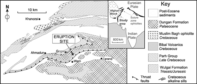 |
Figure 1. Geological sketch map showing the location of the eruption site at Tor Zawar, Pakistan, on 27 January 2010. The site is in the Sari (alternatively Jhari, Charri, or Cherri) area of the Ziarat District of Balochistan Province ~10.6 km N of the village of Wam (Waam). The event took place ~55 km NW of Quetta, Pakistan (~70 km E of the border with Afghanistan) and ~8.1 km E of the town of Gogai. The geological formations on the map are keyed to the stratigraphic section on the right-hand side of the figure. From Kerr, Khan, and McDonald (2010), modified from Khan, Kassi, and Khan (2000). |
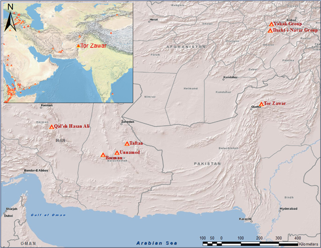 |
Figure 2. Map of the Pakistan-Afghanistan-Iran region showing the relative locations of known Holocene volcanoes with respect to the Tor Zawar event. Of those Holocene volcanoes shown, only Taftan volcano in Iran has possible historically recorded eruptions, which occurred in 1902 and 1993. Locations from Siebert and others (2010); map produced by S. Purcell (GVP). |
News reports from several sources (e.g., The Nation, 3 February 2010; Balochistan Times, 23 February 2010 and 7 March 2010; Ary News, 2 February 2010) noted that residents in nearby areas observed flames at the mountain top for several nights and, on 1 February 2010, the volcano began erupting lava. Explosions followed by smoke emissions were observed. District Coordinator Officer Siddiq Mandokhel confirmed that lava spewed from the volcano. The newspaper Pak Tribune reported on 3 February 2010 that Mandokhel said "he had personally surveyed the site of occurrence, and said that emittance of chemical gases had begun last night, after which it spewed out a molten lava, the size of a meter".
At least two small groups of earth scientists visited the site within 3 to 5 days after the reported 'eruption' event. The field observations by scientists from the GSP were reported in a GSP Information Release (Rana and Akhtar, 2010). Khadim Durrani (2010) issued on his web site an illustrated interview conducted with Din Mohammed Kakar. The two reports mentioned above contain occasional discrepancies within and between the reports, and both include unlabeled figures. During the periods of field observations, no fresh extrusion of volcanic material or sparks was observed. However, heat was still being emitted.
Table 1 contains a brief summary of possible causes and/or production-mechanisms for the molten material that have been suggested by various sources. Additional details are found in sections below.
Table 1. Various explanations for a molten material source and proposed mechanism of erupted surface deposit at Tor Zawar. See original papers for more details.
| Proposed source or mechanism | Comments |
| Melting of existing Bibai volcanics caused by resistive heating due to local power line, lightning, or some combination of surface sources. | Mentioned but dismissed by Rana and Akhtar (2010); 'unsupported' according to Kerr and others (2010; Kakar, in Durrani (2010). |
| Frictionally derived melting along thrust fault. | Rana and Akhtar (2010). |
| Methane gas leakage and flaring with local heating/melting of existing Bibai volcanics. | Bilham (personal communication). |
| Rupture on Gogai Wam fault during 2008 earthquake created chambers from which molten materials rose and eventually erupted through channels in the weak zone. | Rana and Akhtar (2010). |
| Melting from heating of lithosphere either by conduction from below or by advection from an intruding magma. | "It is more likely that a small amount of asthenospheric-derived melt has invaded the lower lithosphere," concluded Kerr and others (2010). |
| 60-80 km deep magma ascended to the surface along Bibai and Gogai thrust faults. | "Eruption represents a geological event of deep origin," according to Kerr and others (2010). |
Field observations by GSP. Two GSP geoscientists, Asif Nazeer Rana and Sardar Saeed Akhtar, visited the site of the molten material (figure 3) on 2 February 2010 and summarized their observations in a GSP report (Rana and Akhtar, 2010). The following information came from that report. Note that most of the figures reproduced below from the GSP report lacked captions.
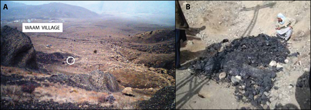 |
Figure 3. Photo of the study site (a) and deposit of solidified molten material (b). The circled area in 'a' shows the location of the molten material deposit. The surrounding dark colored rocks are part of the Cretaceous Bibai Volcanics. The village of Wam (Waam) is visible in the upper part of the picture. Note in figure 'b' the shadow of nearby overhead power lines. Photo 'a' by Din Mohammed Kakar in Durrani (2010); photo 'b' courtesy of Rana and Akhtar (2010). |
The investigators were told on 2 February 2010 by locals that emission of black, molten material started along with tremors on the night of 27 January 2010. The locals observed that steam was continuously emitted from six fissures, and rock fragments were too hot to handle with bare hands. The erupted molten material (looking like lava, scoria and volcanic glass) was found to be cold and solidified on the surface (figures 4 and 5), but was still hot in the subsurface. Heat was still rising from the site during the 3 days of observation.
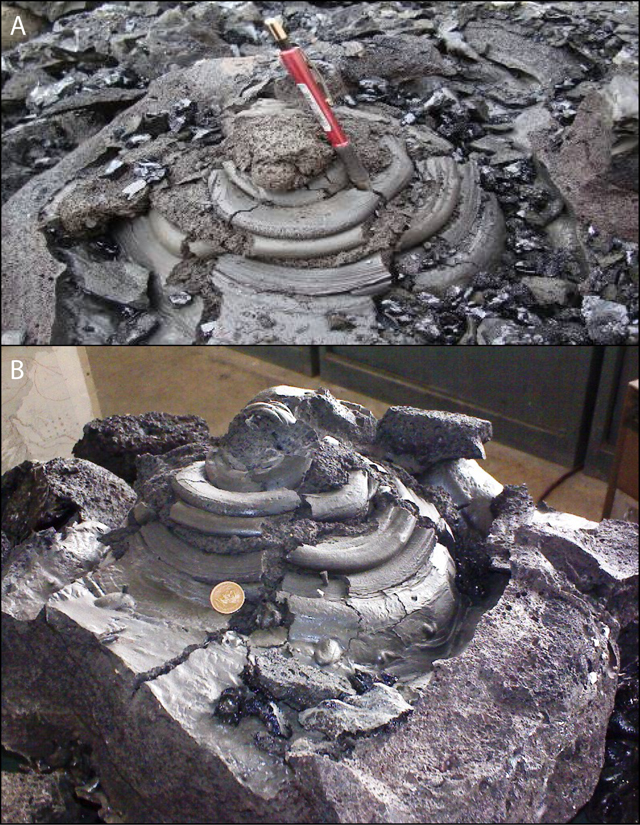 |
Figure 4. (a) Photo of the ejecta cone seen at the surface in the field. Scale provided by red-handled marker pen. Courtesy of Rana and Akhtar (2010). (b) Photo of the ejecta cone removed from the field; some breaking and/or displacement of parts of the cone is apparent. Coin shown was of unknown diameter. Photo courtesy of Kakar, in Durrani (2010). |
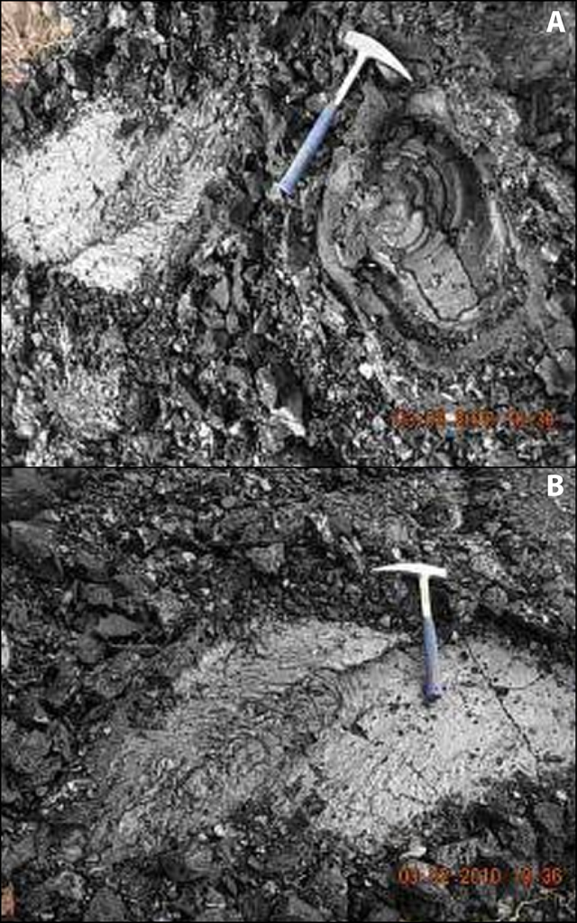 |
Figure 5. Two photos showing the eruption site and the in situ chilled molten material; geological hammers for scale. Courtesy of Rana and Akhtar (2010). |
The molten material flow solidified in concentric layers on reaching the surface (figure 4). The flow structure was ~15 m2 in area and 15 to 60 cm thick. By 2 February, most of the material had been removed as souvenirs by the locals. Rana and Akhtar (2010) reported that the dimension of the lava structure was "1.9 m x 8.2 m in length and 15 cm to 0.6 m thick." The material remaining on the surface after pilferage "was 2.9 m long and 1.5 m wide," covering a area of ~4.3 m2. The ejecta cone was formed from the molten material; the vent pipe of the cone was 0.9 m deep below the surface, but upon excavation it was observed that the cone widened and became inclined below the surface (figure 6).
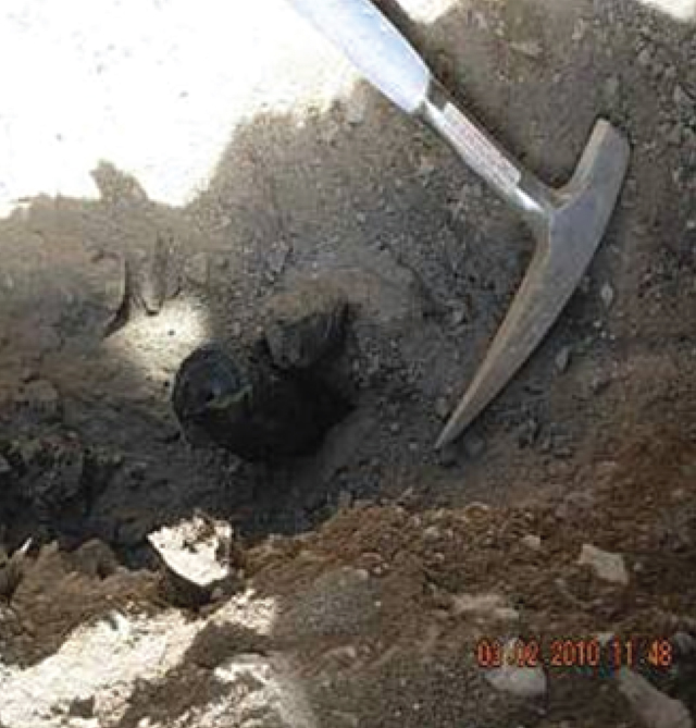 |
Figure 6. Photo of the volcanic pipe from which the ejecta cone in figure 4 was extracted; geological hammer shown for scale. Courtesy of Rana and Akhtar (2010). |
The ejected molten material and ejecta cone were excavated. A ditch was dug along the fissures to find the opening of the vent. The solidified sheet of this molten material was removed from the surface after documentation, measurement, and photography. Samples of various volcanic materials, including volcanic glass, scoria, pumice, and lava, were collected for lab analyses and petrographic studies. The newly erupted material at the surface was removed, and the complete structure of the ejecta cone was preserved and packed for display in the GSP Museum of Earth Sciences (figure 7). Deeper areas were excavated, a pipe-shaped feature was discovered at a depth of 1 m, leading down to a cone-shaped vent.
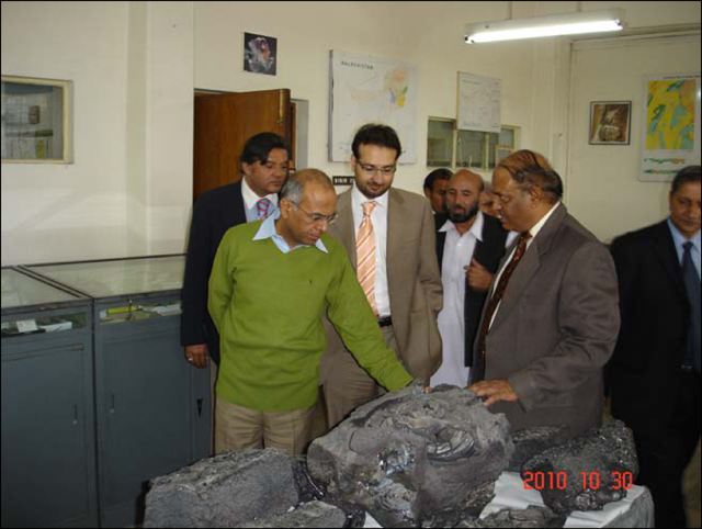 |
Figure 7. Lava excavated from vent on display at the GSP Museum of Earth Sciences. On the right is Imran Khan, Director General of GSP; on the left front in green sweater is Imtiaz Kazi, Federal Secretary, Ministry of Petroleum and Natural Resources. From GSP 2010-2011 Annual Report. |
The cone-shaped vent was fused shut by the solidification of the material in the orifice. Under the ejecta cone, a pipe of 1 m length and 5 cm diameter led vertically down to a funnel-shaped structure (i.e., wider at the top). The ejecta cone was found to be hollow on breaking the pipe and edifice; the structure looked like an oven, with a shiny, black, fine coating on the walls all around. The cone was underlain by two chambers oriented in the NW-SE direction; dimensions of these chambers were not disclosed.
The temperature of the chamber walls was still burning hot, and when dry bushes were put on the mouth of these chambers, they caught fire. The team did not carry a device for measuring soil temperature and steam from the chambers. The smaller, deeper chamber, ~4.75 m from the main chamber, led SE towards an electric power line pole. The temperature of the smaller chamber was seemingly higher than that of the main chamber. The walls of the chambers were still too hot to touch even 10 days after the lava eruption.
Two rock samples, one described as glassy and one as spongy, collected from the Tor Zawar formerly molten material were analyzed chemically at the GSP Geoscience Advance Research Laboratories for major and trace elements chemistry. Analysis revealed sample compositions of silica (SiO2) of 48.02 and 48.27 wt % and total Na2O+K2O of 5.18 and 5.23 wt. %. The two samples were classified as alkaline basalt (based on classification of Cox, Bell, and Pankhurst, 1979).
The depth of the 27 January 2010 M 3.9 earthquake was reported by the Pakistan Meteorological Department to be 60 km. The investigators found this depth to be quite unusual, as a majority of the tremors in this region have had their origin at shallow depths, generally 10-12 km. It was inferred from the previous seismotectonic investigations of 29 October 2009 earthquake (Rana, Sardar, and Qadir, 2008) that earthquake intensities and the alignment and location of most of their epicenters in this area indicated that a blind fault might be running between Gogai and Wam, passing in close proximity to this erution. There is a strong possibility that the present eruption might have occurred close to the fault plane. This blind fault, the Gogai-Wam fault, is suspected to run for nearly 40 km NW-SE, but no trace of any surface rupture was recorded either in the previous study or in the present study.
Visit and assessment by Din Mohammad Kakar. Khadim Durrani interviewed Din Muhammad Kakar, a sedimentary geologist from the University of Balochistan, about his visit and impressions of the site (Durrani, 2010). Kakar noted that a new, small volcano began spewing lava on 29 January 2010 in Pakistan (rather than the 27 January start date reported in the GSP report above). He visited the site on "day 5 after the start of the volcanic activity" (from this, one might infer that his observations were made on 3 February). Kakar observed little molten material other than two "volcanic vents," 2-3 m apart, and the 2-m-deep pit that was dug out by the GSP (figures 8 and 9). He discovered that the GSP and the Frontier Corps (figure 10) had earlier removed parts of the newly erupted cone and the remaining debris. Kakar noted that the heat of the presumed volcanic activity could still be felt in the openings.
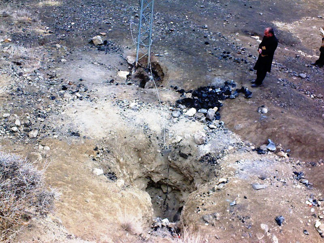 |
Figure 8. Photo of the two volcanic vents (pits/holes/chambers) and scattered pumice fragments. Note the presence of electrical cables and the foot of a power pole, with grounding wire and stake. Photo by Din Mohammed Kakar; courtesy of Durrani (2010). |
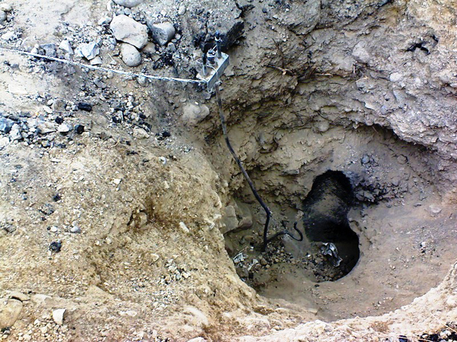 |
Figure 9. A close-up view of one of the vents with grounding wire and ground in figure 8. Photo by Din Mohammed Kakar; courtesy of Durrani (2010). |
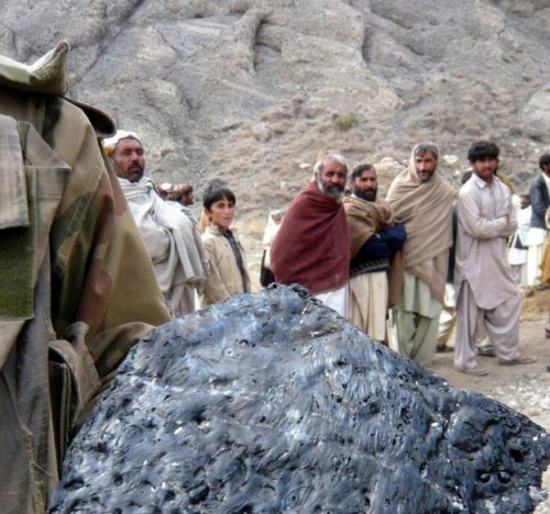 |
Figure 10. Photo of Pakistan Frontier Corps soldier taking away a large piece of the solidified molten material. Photo published 3 February by European Press Agency; courtesy of Durrani (2010). |
According to an Email note from Kakar to Bulletin editors, the chemistry indicates the same alkali basaltic lava as is found in the Bibai volcanics. Kakar noted that the eruption took place within the Late Cretaceous Bibai formation volcanics (see figure 1) (Kahn, 1998). Other exposed rocks in the area include the Parh group (Cretaceous), Dungan formation (Paleocene), and the Ghazij formation (Eocene). In the Kach-Ziarat area, the Bibai formation is sandwiched between Dungan limestone (above) and the Parh formation (below).
Eye witnesses said that there were flames coming out from the vent, possibly the result of ignited natural gas. In discussion with Bulletin editors, Roger Bilham of the University of Colorado offered the possible explanation that the eruption may have represented the remelting of pre-existing rocks of Bibai Volcanics due to ignition and combustion of natural gas.
Kakar said that the regional tectonics and the volcano's origin were not clear. However, the volcano was not a mud volcano, common in Pakistan. There is the possibility of a partial melting at shallow depth due to recent earthquake activities. He recalled the area had been hit by thousands of aftershocks since October 2008. He noted that his research had found a rupture in the basement rock below the 15-km sedimentary cover, and suggested that reactivation of the Bibai thrust might have been responsible for the recent volcanic activity. According to Kakar, the area is sparsely populated and the eruption caused no damage except for cables and poles associated with a tube well used for agricultural purposes.
Petrographic analyses.Two rock samples were sent by the GSP to Cardiff University and analyzed by Kerr and others (2010). The samples showed two petrographically distinct basalt types (figure 11). One type (sample P2) consisted of completely fresh, light brown glass with a few (
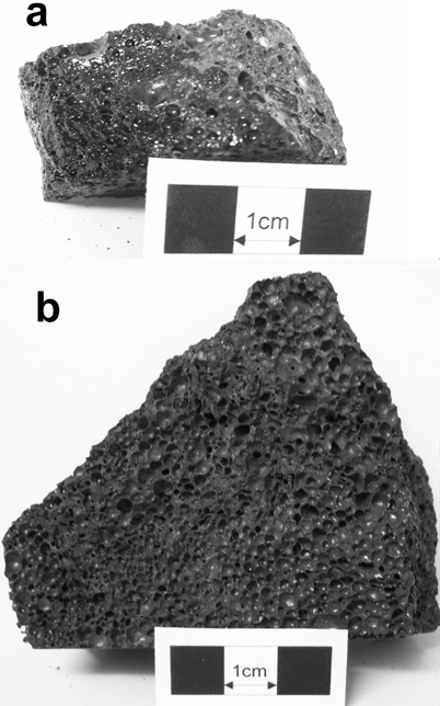 |
Figure 11. Photographs of the 2010 Tor Zawar samples analyzed by Kerr and others (2010). (a) devitrified sample (P1); and (b) glassy sample (P2). Courtesy of Kerr and others (2010). |
According to Kerr and others (2010), these two rock types "also have slightly different geochemical signatures that can be partially explained by crustal assimilation. Re-melting of local basaltic rocks by short circuiting of a ruptured high-tension electrical cable is considered unlikely. Mantle melt modeling suggests that the lavas have been largely derived from a source in the garnet-spinel transition zone, i.e. well within the lithosphere [i.e., melt from a depth of 60-80 km]. It is proposed that localized asthenospheric melting resulted in relatively depleted melts which were substantially contaminated by [a] fusible lithospheric mantle en route to the surface. Further small-scale eruptions cannot be ruled out."
Recent geophysical research. In the last week of March 2010, the GSP conducted a geophysical survey in the region of the Tor Zawar vent site (Saeed, Rehman, and Abbas, 2011). According to the report, "The syntheses of the magnetic, resistivity soundings and profiling and ground penetration radar (GPR) survey indicate the presence of highly magnetic dual lobe sources, resistive and prominent reflectors from the radar soundings in and around the vent site. The resistivity pseudo sections delineate the lateral and vertical molten flows which have apparently solidified at shallow depth."
The report concluded that "the radar imaging explicitly shows folding of the overlying fine grained clastics", and that they also saw "fracturing in the compact, hard and brittle rock units of compact gravels/limestone and volcanics due to the pressure exerted by the intrusion."
The presence of older volcanic rocks in the area made it difficult to separate older volcanic rocks and structures from the present eruption activity. The geophysical survey was unable to resolve the source or sources of the molten material that erupted as basalt.
References. Cox, K.G., Bell, J.D., and Pankhurst, R.J., 1979, The interpretation of igneous rocks, George Allen and Unwin, Boston, 450 pp.
Durrani, K., 2010, Ziarat's volcanic coughing - an interview with Din Mohammed Kakar, published by admin, March 2, 2010 in Environment, Geology of Pakistan and Natural Disasters, URL: www.khadimsquetta.com/?p=640. (Note that many of the photos in this website item are not described or labeled.)
Geological Survey of Pakistan (GSP), 2011, GSP Year Book 2010-2011, on GSP web site: http://www.gsp.gov.pk.
Kakar, D.M., Szeliga, W., and Bilham, R., 2010, Seismic Potential of the Pishin/Mach Shear Zone in Northern Baluchistan, Pakistan, Seismological Research Letters, v. 81, no. 2, pp. 324.
Khan, A.T., 1998, Sedimentology and petrology of the volcaniclastic rocks of the Bibai Formation, Ziarat District, Balochistan, Pakiston, Thesis, University of Balochistan, Quetta, 179p.
Khan, A.T., Kassi, M.T. and Khan, A.S., 2000, The Upper Cretaceous Bibai submarine Fan (Bibai Formation), Kach Ziatrat Valley, western Suleiman Thrust-Fold Belt, Pakistan, Acta Mineralogica Pakistanica, v. 11, pp. 1-24.
Kerr, A.C., Khan, M., and McDonald, I., 2010, Eruption of basaltic magma at Tor Zawar, Balochistan, Pakistan on 27 January 2010: geochemical and petrological constraints on petrogenesis, Mineralogical Magazine, v. 74, no. 6, pp. 1027-1036.
MonaLisa, and Jan, M.Q., 2010 (10 January), Geoseismological study of the Ziarat (Balochistan) earthquake (doublet?) Of 28 October 2008, Current Science, v. 98, no. 1, p. 50-57.
Rana, A.N., Sardar, S.A., and Qadir, G.T., 2008, Seismotectonic investigations of October 29, 2008 earthquake of Gogai Ziarat, Balochistan, Information Release No. 874, Geological Survey of Pakistan, Islamabad.
Rana, A.N., and Akhtar, S.S., 2010, Preliminary Report on Eruption of Molten Material in Tor Zawar Mountain, Sari, Ziarat, Balochistan on January 27, 2010, Information Release No. 891, Geological Survey of Pakistan, Islamabad, 24 pp. (Summarized in GSP News. V. 17, no. 1-12, p. 12.) (Note that many of the photos in this website item are not described or labeled.)
Saeed, M., Rehman, M., and Abbas, S.A., 2011, Integrated geophysical modeling of volcanic eruption at Tor Zawar, Ziarat, Balochistan, Information Release No. 920, Geological Survey of Pakistan, Islamabad, 79 pp.
Siebert, L., Simkin, T., and Kimberly, P., 2010, Volcanoes of the World, Third Edition, Smithsonion Institution, Washington, D.C., and University of California Press, Berkeley, CA, 551 pp.
Geological Summary. False or otherwise incorrect reports of volcanic activity.
Information Contacts: Imran Khan, Director General, Geological Survey of Pakistan, Sariab Road, Quetta, Pakistan (URL: http://www.gsp.gov.pk); Din Mohammed Kakar, Geology Department, University of Balochistan, Quetta, Pakistan (URL: http://www.uob.edu.pk/); Andrew C. Kerr, Cardiff University, School of Earth and Ocean Sciences, Cardill, Wales, UK (URL: http://www.Cardiff.ac.uk/earth/contactsandpeople/profiles/kerr-andrew.html); Khadim Durrani; Roger Bilham, University of Colorado.