Report on Papandayan (Indonesia) — June 2012
Bulletin of the Global Volcanism Network, vol. 37, no. 6 (June 2012)
Managing Editor: Richard Wunderman.
Papandayan (Indonesia) Seismic increases in July and August 2011, with no eruption
Please cite this report as:
Global Volcanism Program, 2012. Report on Papandayan (Indonesia) (Wunderman, R., ed.). Bulletin of the Global Volcanism Network, 37:6. Smithsonian Institution. https://doi.org/10.5479/si.GVP.BGVN201206-263100
Papandayan
Indonesia
7.32°S, 107.73°E; summit elev. 2665 m
All times are local (unless otherwise noted)
Minor seismic activity and fumarolic plumes at Papandayan occurred in July 2005, July and August 2007, and April 2008 (BGVN 33:06; figure 9). This report covers a seismic swarm reported in July and August 2011. According to the Center of Volcanology and Geological Hazard Mitigation (CVGHM), Papandayan is monitored by eight seismic stations (three permanent and five temporary).
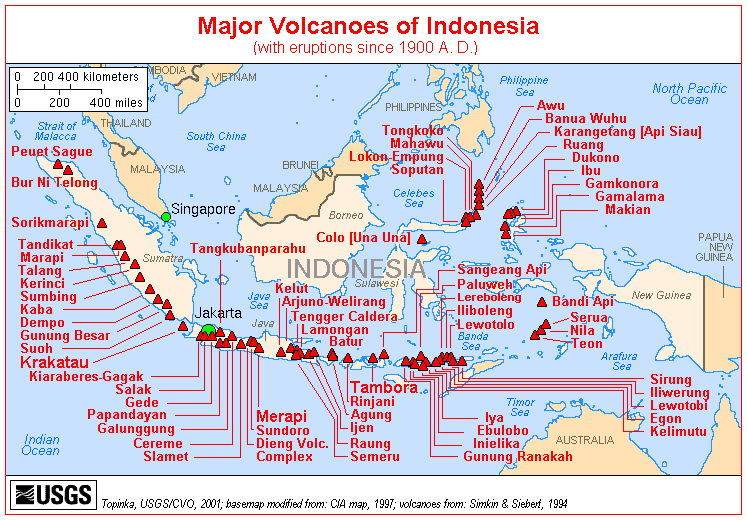 |
Figure 9. A map showing the location of Papandayan relative to many other Indonesian volcanoes of Holocene age. Courtesy of USGS. |
Since April 2008, reports on seismicity were sparse. Then, in July 2011, seismicity increased; several hundred earthquakes were detected per month, and the occurrence of deep earthquakes nearly tripled. (figure 10, table 4).
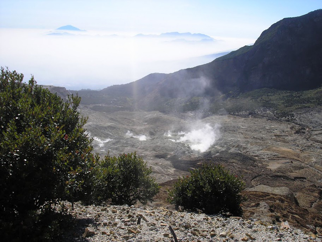 |
Figure 10. Papandayan crater as seen from the trail to Pondok Salada in August 2011. Courtesy of Daniel Quinn. |
Table 4. The occurrence of various types of seismicity at Papandayan during July-24 August 2011. '--' indicates data not reported. Data from CVGHM.
| Date | Deep volcanic | Shallow volcanic | Low-frequency | Distant Tectonic | Local Tectonic |
| Jun 2011 | 31 | 339 | 9 | 112 | 37 |
| Jul 2011 | 91 | 431 | 9 | 165 | 97 |
| 1-24 Aug 2011 | 94 | 501 | -- | 100 | 34 |
According to CVGHM, sulfur-dioxide (SO2) plumes rose 20-75 m above the vents between 1 June and at least 12 August 2011. Between 12-23 August, SO2 emissions ranged from 3-8 tons per day. Carbon dioxide (CO2) levels measured in the soil at 1 m depth in multiple areas did not increase. The temperature in the Manuk thermal area increased during 29 June to 12 August, and deformation measurements indicated inflation from 4 July to 10 August. On 13 August 2011, CVGHM announced that the Alert Level for Papandayan had been increased to 3 (on a scale of 1-4) based on seismicity, deformation, geochemistry, and visual observations. Visitors and residents were warned not to venture within 2 km of the active crater. The increase spurred multiple news reports.
On 14 August 2011, the Jakarta Globe reported that Sutopo Purwo Nugroho, a spokesman for the National Disaster Mitigation Agency, had stated that gas was emanating from three craters - Walirang, Manuk and Balagadama. The same report quoted Surono, who heads CVGHM, as saying: "For now, we are not too worried about a major eruption. We are more concerned by the toxic gas."
According to other news reports, by mid-August 2011 local officials had completed evacuation planning, especially for three vulnerable villages within 7 km of the active crater. The report also mentioned that as of 19 August, residents near the volcano were continuing their normal activities, but that tourist visitation had dropped sharply at the popular destination.
On 26 August 2011, CVGHM reported that Papandayan's activity had not increased during the previous few days. Seismicity remained high, but stable, and was dominated by shallow volcanic earthquakes. Deformation measurements (such as leveling and Electronic Distance Measurement - EDM) showed no change, and water temperatures in multiple fumarolic areas and lakes remained relatively constant.
On 31 January 2012, CVGHM lowered the Alert Level from 3 to 2, without indication of eruption details or reasons for the change. As of 30 June 2012, the Alert Level remained at 2.
Crater emission videos. Video clips of crater emissions taken at Papandayan in October 2009, and at an uncertain other date can be found on YouTube:
Pwarr3n, 2009, YouTube (URL: http://www.youtube.com/watch?feature=endscreen&NR=1&v=H_GIwMdkWT8).
Sweetmarias, undated, posted 13 August 2010, YouTube (URL: http://www.youtube.com/watch?v=tSFoybapqe0).
Geological Summary. Papandayan is a complex stratovolcano with four large summit craters, the youngest of which was breached to the NE by collapse during a brief eruption in 1772 and contains active fumarole fields. The broad 1.1-km-wide, flat-floored Alun-Alun crater truncates the summit of Papandayan, and Gunung Puntang to the north gives a twin-peaked appearance. Several episodes of collapse have created an irregular profile and produced debris avalanches that have impacted lowland areas. A sulfur-encrusted fumarole field occupies historically active Kawah Mas ("Golden Crater"). After its first historical eruption in 1772, in which collapse of the NE flank produced a catastrophic debris avalanche that destroyed 40 villages and killed nearly 3000 people, only small phreatic eruptions had occurred prior to an explosive eruption that began in November 2002.
Information Contacts: Center of Volcanology and Geological Hazard Mitigation (CVGHM), Jalan Diponegoro 57, Bandung 40122, Indonesia (URL: http://www.vsi.esdm.go.id/); Jakarta Globe (URL: http://www.thejakartaglobe.com).