Report on Ijen (Indonesia) — July 2012

Bulletin of the Global Volcanism Network, vol. 37, no. 7 (July 2012)
Managing Editor: Richard Wunderman.
Ijen (Indonesia) 2012 high seismicity, blasts, and subaqueous emissions; maps of complex
Please cite this report as:
Global Volcanism Program, 2012. Report on Ijen (Indonesia) (Wunderman, R., ed.). Bulletin of the Global Volcanism Network, 37:7. Smithsonian Institution. https://doi.org/10.5479/si.GVP.BGVN201207-263350
Ijen
Indonesia
8.058°S, 114.242°E; summit elev. 2769 m
All times are local (unless otherwise noted)
This report first documents earthquakes at or near Kawah Ijen and minor emissions within its crater lake during mid-December 2011 to mid-2012. These earthquakes and emissions were ongoing at press time.
The second and third subsections below present maps and background relating to the Ijen complex. As discussed in earlier reports, Ijen is the name often applied to the larger complex consisting of a large caldera and associated cones. Kawah Ijen is the name of the intracaldera cone that contains a crater with an acid briny lake 700 x 800 m in diameter. The coordinates cited in the header and Summary for this volcano refer to the approximate center of the lake (see photos of the lake in Photo Gallery and figure 4 in BGVN 32:02; Demelle and others, 2000; Takano and others, 2004). Kawah Ijen, the active vent of the complex, is known for hydrothermal and phreatic behavior in its crater lake. During this reporting interval an intrusion appears to have risen to a shallow depth beneath the crater lake. Subaqueous sulfur-bearing emissions seemingly occurred on the lake floor.
The last subsection briefly calls attention to sulfur mining near Kawah Ijen's crater lake. Laborers carry heavy loads of native sulfur across steep terrain as they breathe air rich in volcanic gases. Recent dental studies cited in this subsection compared the teeth and gums of laborers to residents living nearby who endured less exposure to the volcanic gases. They found that the laborers suffered more tooth and gum disorders.
Mid-December 2011 to mid-2012. According to a summary of activity by the Center for Volcanology and Geological Hazard Mitigation (CVGHM) and the USGS Volcano Disaster Assistance Program (VDAP), Ijen volcano has been in a state of heightened unrest centered at Kawah Ijen since May 2011, a time when teams installed, tested, and conducted training on the use of upgraded seismic instrumentation. As previously reported in BGVN 36:12, increased seismicity and fumarole temperatures caused CVGHM to raise the Alert Level from 1 to 2 (on a scale of 1-4) on 15 December 2011.
On 18 December, after observing further increases in both seismicity and degassing, CVGHM established Alert Level 3. In the next few months, scientists documented four periods of significant unrest. They occurred on 20 and 30 December 2011, 4 January 2012, and 2 March 2012.
On 1 January 2012, CVGHM recorded a swarm of earthquakes, raising concerns of renewed pressure in the then-inferred shallow magmatic system. The agency's reports also noted shifts in the rates of recent high-frequency earthquakes (believed to be associated with breaking rocks). Increases occurred in both low-frequency earthquakes and tremor (both believed to be associated with the movement of fluids). At the crater lake, debris (probably native sulfur) seen floating on the surface was judged as likely derived from emissions vented into the ~180-m-deep lake (Takano and others, 2004). Congruent with that interpretation, sulfurous-gas emissions measured just over the lake surface were very high at the time.
On 8 February 2012, after decreases in seismicity, and visual and thermal signs of unrest at Kawah Ijen, CVGHM lowered the Alert Level to 2.
Sharp increases in seismicity prevailed after 2 March 2012, which spurred CVGHM to raise the Alert Level to 3 on 12 March. Elevated crater lake temperatures (up to 43°C at 5 m depth) and gas plumes to 100-200 m above the summit had been reported. These observations led CVGHM and VDAP to suggest an intrusion of magma had reached the point where it caused perturbations to the extensive hydrothermal system in the shallow conduit and crater lake.
During 1-30 April 2012 white plumes from Kawah Ijen rose 100-200 m above the crater, and during 1-11 May diffuse white plumes rose 50-100 m above the crater. During this time and through 13 May, the amplitude and number of earthquakes gradually decreased and the crater lake water temperature decreased by 8°C. On 13 May 2012, CVGHM again lowered the Alert Level to 2. Later, on 24 July 2012, they again raised the Alert Level to 3. Authorities posted a 1.5-km-radius no-entry zone around the lake's center.
Visual and seismic observations published in CVGHM's report of 24 July 2012 indicated repeated hot air-blasts during 1-24 July. The blasts sent plumes rising to 50-100 m over the summit, and registered seismically as follows: 1-7 July, 8 blasts; 8-14 July, 12; 15-21 July, 40; and 22-24 July, 32. During those same intervals volcanic earthquakes occurred between 36 and 273 times per interval, with the maximum occurring during 15-21 July, the same interval as the largest number of air-blasts (but not the highest average rate of air blasts per day, which occurred during 22-24 July). Various other earthquake types were recorded in the same report. Although background seismicity typically had amplitudes in the range 0.5-5 mm, many of the larger amplitude air-blasts reached 20-40 mm with durations up to 18 seconds.
Maps, hazards, and Ijen's Merapi. The Ijen complex resides at the E end of Java just across the strait from Bali (figure 13, inset map). Kawah Ijen sits at the E end of the complex within the caldera (figure 13, main map).
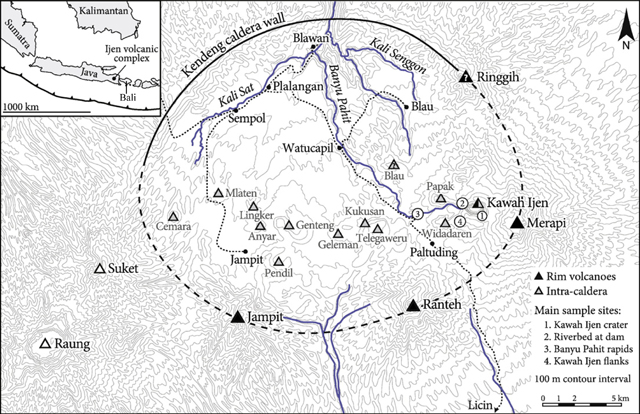 |
Figure 13. (Inset, upper left) Overview map illustrating the Ijen volcanic complex located in Eastern Java, accross the strait from Bali. (Main map) The large sub-circular shape indicates the margin of the Ijen caldera. The active Kawah Ijen cone is in the E part of the caldera. The solid and dashed line segments respectively discriminate between the well constrained N topographic margin ("Kendeng caldera wall") and the inferred S margin. Associated volcanic centers reside both inside the caldera (lightly shaded triangles), and on the rim (solid black triangles). In this interpretation of the caldera, it is ~13 km wide. The caldera drains to the N in a river system that starts at the outflow from the crater lake. The major river is called Banyu Pahit (also spelled Banyuputhih). Raung and Suket cones sit W of and outside the Ijen complex. From van Hinsberg and others (2010). |
Figures 14 and 15 illustrate foreseen hazardous areas and the regional context, including cities around the Ijen complex. The circles shown on both maps are centered around the Kawah Ijen cone and its crater lake.
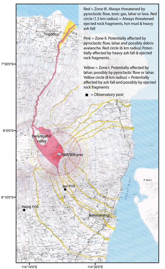 |
Figure 14. Map of the Ijen complex showing hazard zones (Yellow–Zone I; Pink–Zone II, and Red–Zone III; as described in the legend at right). For scale, a small (rather faint) inner red dashed ring around Kawah Ijen crater and the lake it encloses has a diameter of 1.5 km; the pink dashed ring, 6 km, and the outer yellow ring, 8 km. The lake's surface is at 2,200 m elevation. Note location of observation posts. The large urban area on the N coast has a population of 1.5 million and is here labeled Trigonco (but other local names apply, as seen in figure 15). Map extracted from an original prepared by Mulyana, A.R., Effendi, W., Karim, A., and Rukada, T. (2006). Courtesy of CVGHM and VDAP. |
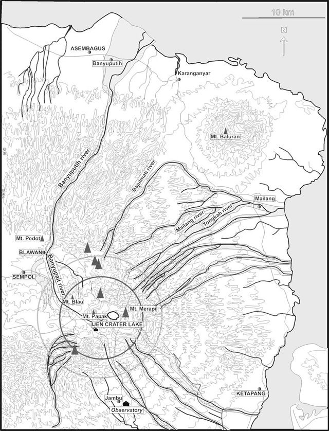 |
Figure 15. A hazard map of the Ijen complex at slightly smaller scale than figure 14, with names of key drainages that could funnel floods, lahars, pyroclastic flows, and lavas. Original source unknown; from van Bergen and others (2000). |
Both figures 14 and 15 emphasize the attendant lahar hazards. Regarding floods and lahars, the crater lake at Kawah Ijen has a volume of ~30 million cubic meters, all or part of which could be expelled in an eruption or breakout due to crater-wall failure, an event that could send acidic brines down one or more of the drainages. About 5,000 people live within 10 km of the lake but farther away, many thousands more would be at risk in the event of large lahars.
The port cities to the N have a population of ~1.5 million and lie near the mouth of a river representing the main drainage from within the caldera, including the controlled outflow from the crater lake (figures 14 and 15).
As seen on a relief map (figure 16), Merapi (on the far E side of the caldera) forms the highest point in the complex, 2,799 m (and reflects the summit elevation value we typically provide for the complex). Merapi is the same name applied to the better-known, regularly erupting volcano in Central Java near the city of Yogyakarta. Another potential confusion is the volcano Marapi on the island of Sumatra.
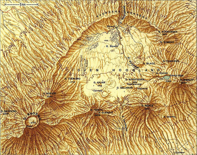 |
Figure 16. Shaded relief map of the Ijen (shown here as the Idjen) volcanic complex published in 1937 ("Topogr. Dienst, 1937"). Kawah Ijen cone, with its associated crater and lake, appears near the E side of the complex on the flank of the taller Merapi cone. Prominent topographic highs are labeled, typically preceded by the letter G (from the word Gunung, which means peak or mount in Indonesian). Courtesy of Wikipedia. |
Figure 16 shows the Kendeng mountains defining the caldera's arcuate topographic margin bounding the N (with elevations up to 1,559 m). The lowest point of the caldera's N rim (~850 m) occurs near Blawan village at the breach in the caldera wall. Starting at the SE, the major cones on or near the S margin (on this map) are Merapi (2,799 m, and on its flanks, Kawah Ijen at 2,386 m), Rante, and the closely spaced Pendil Djampit.
Just N of Pendil Djampit lies a fault with offset down towards the caldera (figure 17). It trends NW and curves to the N, helping to establish the path of the inferred SW caldera margin (figure 13).
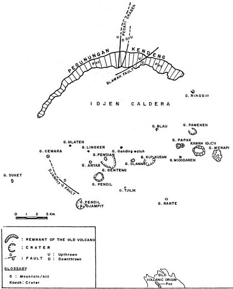 |
Figure 17. Sketch map of Ijen showing several faults and the morphology of the string of eruptive centers strung E to W across the caldera floor. From van Bergen and others (2000). |
A separate volcano in the GVP database, Raung (Raoeng) stratovolcano (3,332 m), forms a distant topographic feature well to the W of the flat caldera floor and SW boundary (figures 13, 16, and 17). As here defined, Raung includes two other remote cones as subfeatures. One is the cone located to Raung's NE, Soeket (Suket) stratovolcano (2,950 m). Both Suket and Raung lie along the western topographic divide for the drainage basin that feeds into the Ijen complex.
Model of the crater-lake system. Given the recent concerns about activity in Kawah Ijen's crater lake, a simple model of the shallow crust in this area provides a way to help visualize conditions and processes in the subsurface. Figure 18 shows the general situation as put forth in a simple sketch by Alain Bernard (van Bergen and others, 2000).
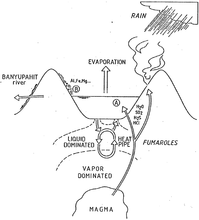 |
Figure 18. A simplified model of the environment and subsurface associated with Kawah Ijen's crater lake. This illustrates some of the factors associated with the lake's chemistry, including rainfall, runoff, surface-rock weathering, and the interconnected hydrothermal, geochemical, and magmatic systems. Taken from van Bergen and others (2000). |
van Bergen and others (2000) made the following remarks: "The lake chemistry is determined by dissolution of magmatic volatiles, fluid-rock interaction, evaporation of the lake water, dilution by meteoric water and recycling of lake water through seepage into the subsurface hydrothermal system. The lake acts as [a] chemical condenser for volatiles and as a calorimeter trapping heat supplied by a shallow magmatic reservoir. Magmatic volatiles can be supplied to the crater lake system by direct injection of magmatic vapours (SO2, H2S, HCl, and HF) via subaqueous fumaroles or via hot brines entering at the lake bottom."
van Hinsberg and others (2010) stated the following: "The crater lake of Kawah Ijen volcano represents the largest body of natural hyperacidic brine in the world (Delmelle and Bernard, 1994) and has been present since at least 1789 (cf. Bosch, 1858). It is characterised by a singularly high dissolved element load (>100 g/L) and very low pH. Fluids from the crater lake seep through [Kawah Ijen's] western flank to form the acid Banyu Pahit river, the water of which is eventually used for irrigation 40 km downstream [to the N] of the lake in the coastal plain of Asambagus."
Sulfur mining. A strongly active solfatara field (fumaroles that are characteristically sulfurous) is present in the SE part of Kawah Ijen's crater near the lakeshore, where sulfur-mining activities have existed for many decades (see figure 8 in BGVN 32:09). Local workers channel some of the fumarolic gases and molten condensates through pipes and out onto the ground. Once the liquid cools and hardens, workers break the solid sulfur into large pieces and load it into baskets for manual transport out of the crater. According to Wikipedia, miners carry loads of sulfur ore blocks ranging from 75 to 90 kg up a steep trail to the crater rim and then 3 km down the mountain to a weighing station. That and many other web sites show photos of the mining process. Among the more recent photos of the scene are those by Oliver Grunewald (2010) on the 'boston.com' web site. He points out that few of the miners possess gas masks.
Two dental studies of miners concluded that they had both higher incidence of dental erosion to the enamel on their teeth (Pranani and Wibisono, 2008) and the gum disease gingivitis (Anitasari and Wibisono, 2008). Both studies attribute these problems to exposure to sulfuric acid fumes. The studies were small (30 miners) and for comparison (control groups) used similar numbers of residents who lived around the mine but did not work as miners.
References. Anitasari, S. and Wibisono, G., 2008, Relationship between the length of sulphuric acid fumes exposure and the grade of gingivitis, Studies on the Sulphur Miners at Mount Ijen Banyuwangi East Java, Fakultas Kedokteran, Disusun oleh:NIM: G2A004170, Fakultas Kedokteran, Universitas Diponegoro, Semaran, 18 pp.
Bosch, C.J., 1858. Uitbarstingen der vulkanen Idjin en Raun (Banjoewangi). Tijdschrift voor Indische Taal-, Land- en Volkenkunde, Deel 7, 265–286.
Delmelle, P., Bernard, A., Kusakabe, M., Fischer, T.P., and Takanod, B., 2006, Geochemistry of the magmatic–hydrothermal system of Kawah Ijen volcano, East Java, Indonesia, J. of Volcanology and Geothermal Research, Vol. 97, Issues 1-4, April 2000, pp. 31-53.
Grunewald, O., 2010, Kawah Ijen at night, Updated 8 December 2010, Accessed 7 Sept 2012 (URL: http://www.boston.com/bigpicture/2010/12/kawah_ijen_by_night.html).
Topogr. Dienst, 1937, Atlas van Tropisch Nederland, original reproduced on Wikipedia Commons web site (http://commons.wikipedia.org/wiki/File:Ijen.JPG) entitled 'Ijen', Updated 17 June 2012, Accessed 29 August 2012.
Mulyana, A.R., Effendi, W., Karim, A., and Rukada, T., 2006, [Ijen hazards map, figure 14 (further citation details currently unavailable)].
Pranani, D. and Wibisono, G., 2008, The influence of sulphuric acid fumes exposure on the incidence of dental erosion, Study on sulphuric miner in Mount Ijen, Banyuwangi, East Java, Dyah Pranani, NIM: G2a004055, Fakultas Kedokteran, Universitas Diponegoro Semarang, 18 pp.
Takano, B., Suzuki, K., Sugimori, K., Ohba, T., Fazlullin, S.M., Bernard, A., Sumarti, S., Sukhyar, R., and Hirabayashi, M., 2004, Bathymetric and geochemical investigation of Kawah Ijen Crater Lake, East Java, Indonesia, J. of Volcanology and Geothermal Research, vol. 135, Issue 4, pp. 299–329.
van Bergen, M.J., Bernard, A., Sumarti, S., Sriwana, T., and Sitorus, K., 2000, Crater lakes of Java: Dieng, Kelud and Ijen, Excursion Guidebook, IAVCEI General Assembly, Bali 2000, 43 p.
van Hinsberg, V., Berlo, K., and van Bergen, M.J., 2010, Extreme alteration by hyperacidic brines at Kawah Ijen volcano, East Java, Indonesia: I. Textural and mineralogical imprint, J. of Volcanology and Geothermal Research, Vol. 198, Issues 1–2, pp. 253–263.
Geological Summary. The Ijen volcano complex at the eastern end of Java consists of a group of small stratovolcanoes constructed within the 20-km-wide Ijen (Kendeng) caldera. The north caldera wall forms a prominent arcuate ridge, but elsewhere the rim was buried by post-caldera volcanoes, including Gunung Merapi, which forms the high point of the complex. Immediately west of the Gunung Merapi stratovolcano is the historically active Kawah Ijen crater, which contains a nearly 1-km-wide, turquoise-colored, acid lake. Kawah Ijen is the site of a labor-intensive mining operation in which baskets of sulfur are hand-carried from the crater floor. Many other post-caldera cones and craters are located within the caldera or along its rim. The largest concentration of cones forms an E-W zone across the southern side of the caldera. Coffee plantations cover much of the caldera floor; nearby waterfalls and hot springs are tourist destinations.
Information Contacts: Center of Volcanology and Geological Hazard Mitigation (CVGHM), Jalan Diponegoro 57, Bandung 40122, Indonesia (URL: http://www.vsi.esdm.go.id/); Volcano Disaster Assistance Program (VDAP), US Geological Survey (USGS), 1300 SE Cardinal Court, Bldg. 10, Suite 100, Vancouver, WA 98683.