Report on Kikai (Japan) — July 2012
Bulletin of the Global Volcanism Network, vol. 37, no. 7 (July 2012)
Managing Editor: Richard Wunderman.
Kikai (Japan) Low level tremor and frequent white plumes during October 2010-June 2012
Please cite this report as:
Global Volcanism Program, 2012. Report on Kikai (Japan) (Wunderman, R., ed.). Bulletin of the Global Volcanism Network, 37:7. Smithsonian Institution. https://doi.org/10.5479/si.GVP.BGVN201207-282060
Kikai
Japan
30.793°N, 130.305°E; summit elev. 704 m
All times are local (unless otherwise noted)
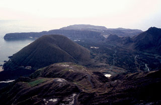
Kikai was the scene of ongoing steaming and modest seismic unrest during October 2010-June 2012. As background, Kikai (also called Satsuma-Iwo-jima and Tokara-Iwo-jima), an island on the NW rim of the submerged Kikai caldera (figure 1), experienced chiefly low-level seismicity between 2002 and 2004 punctuated by stronger earthquakes and tremor, and three small eruptions during May-June 2002, June-August 2003, and March-September 2004 (BGVN 28:04 and 30:07). Almost daily plumes, most of which were white, occurred between late 2002 and at least January 2005 (BGVN 30:07).
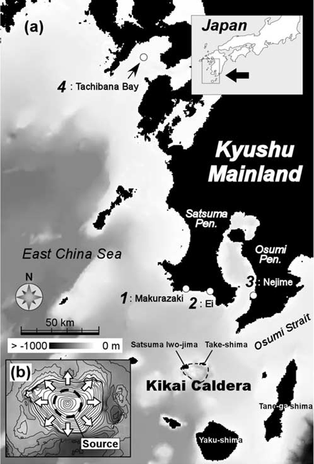 |
Figure 1. Maps showing Kikai caldera and the two associated islands along its rim, Satsuma-Iwo-jima and Tokara-Iwo-jima. The top-right inset map shows the regional extent of the main figure; the lower-left inset map (b) relates to the author's proposed model of pyroclastic flow venting and tsunami generation. Taken from Maeno and Imamura (2007). |
Recent monthly reports of volcanic activity from the Japan Meteorological Agency (JMA) translated into English resumed in October 2010. Thus, in this report, we lack JMA reports between January 2005 and September 2010 and only summarize and tabulate activity after October 2010 and as late as June 2012.
In an effort to gather other information, we searched for MODVOLC thermal alerts at Kikai and found none during January 2005 to late September 2012. Only one alert appeared in the past decade. That weak alert occurred on 2 August 2003 at a point along the coast well to the NE of the crater. This was unlikely the result of eruptive causes owing to the location and extended absence of alerts at the crater and dome. Near-source thermal photography (noted by JMA and mentioned below) revealed subtle thermal anomalies suggesting elevated temperatures over parts of the dome.
According to JMA, seismicity was relatively low during October 2010-June 2012. Slight increases occurred during 28-31 October 2010 and on 21 August 2011 (Table 3). White-plumes appeared at Iodake summit crater, and their size remained above background throughout the reporting period (Table 3). An occasional night-time glow was visible with a high-sensitivity camera, during at least January-April 2011, July-August 2011, February 2012, and May-June 2012.
Table 3. Monthly summary of seismicity and plume observations at Kikai during October 2010-June 2012. All reported plumes were described as white. All reported volcanic tremor was of small amplitude and short duration. Seismicity in October 2010 was low (as shown) except for occasional increases on 28, 30 and 31 October. The tremor during February 2011 was the first to occur since February 2010. '-' indicates data not reported. Data courtesy of JMA.
| Date | Number of tremor events | Number of earthquakes ("low" through June 2011) | Avg. plume height (maximum height) above Iodake crater (m) |
| Oct 2010 | 0 | Low | -- (--) |
| Nov 2010 | 0 | Low | 200 (300) |
| Dec 2010 | 0 | Low | 100 (300) |
| Jan 2011 | 0 | Low | 100 (300) |
| Feb 2011 | 1 | Low | 100 (300) |
| Mar 2011 | 1 | Low | |
| Apr 2011 | 1 | Low | |
| May 2011 | 1 | Low | |
| Jun 2011 | 1 | Low | |
| Jul 2011 | 8 | 202 | |
| Aug 2011 | 0 | 244 | |
| Sep 2011 | 0 | 119 | |
| Oct 2011 | 2 | 169 | |
| Nov 2011 | 0 | 159 | -- (600) |
| Dec 2011 | 0 | 167 | -- (300) |
| Jan 2012 | 0 | 209 | -- (300) |
| Feb 2012 | 0 | 189 | -- (200) |
| Mar 2012 | 1 | 201 | -- (400) |
| Apr 2012 | 1 | 126 | -- (300) |
| May 2012 | 0 | 212 | -- (600) |
| Jun 2012 | 1 | 204 | -- (300) |
Aerial infrared observations on 14 December 2010 and during November-December 2011 found that the distribution of thermal anomalies in the crater had not changed since previous observations in April 2008 and on 22 December 2009. In addition, according to the Japanese Coast Guard, the summit crater did not visibly change between observations on 22 October 2010 and 19 January 2011. According to a field survey on 26 November 2011, the sulfur-dioxide flux averaged 800 tons per day. In December 2011, discolored water, apparently caused by volcanic activity, was observed near the coast. No remarkable crustal change was observed by GPS during Janurary 2012-June 2012.
The journal Earth, Planets and Space produced an edition in 2002 with 16 articles devoted to Kikai caldera, Satsuma-Iwo-jima, and related topics (Shinohara and others, 2002). A video entitled "Satsuma-Iwojima, Japan" uploaded to Youtube in September 2008 shows a steaming fumarole with bright yellow (sulfur?) incrustations (str4hler, 2008).
References. Maeno, F. and Imamura, F., 2007, Numerical investigations of tsunamis generated by pyroclastic flows from the Kikai caldera, Japan, Geophysical Research Letters, Vol. 34, L23303 (DOI: 10.1029/2007GL031222).
Shinohara, H., Iguchi, M., Hedenquist, J.W., and Koyaguchi, T., 2002, Preface to special volume, Earth, Planets and Space, Vol. 54 (No. 3), pp. 173-174.
str4hler, 2008, [Video] Satsuma-Iwojima, Japan. Accessed 21 September 2012, uploaded to Youtube on 16 September 2008 (URL: http://www.youtube.com/watch?v=jyIhaEQAPlw).
Geological Summary. Multiple eruption centers have exhibited recent activity at Kikai, a mostly submerged, 19-km-wide caldera near the northern end of the Ryukyu Islands south of Kyushu. It was the source of one of the world's largest Holocene eruptions about 6,300 years ago when rhyolitic pyroclastic flows traveled across the sea for a total distance of 100 km to southern Kyushu, and ashfall reached the northern Japanese island of Hokkaido. The eruption devastated southern and central Kyushu, which remained uninhabited for several centuries. Post-caldera eruptions formed Iodake (or Iwo-dake) lava dome and Inamuradake scoria cone, as well as submarine lava domes. Recorded eruptions have occurred at or near Satsuma-Iojima (also known as Tokara-Iojima), a small 3 x 6 km island forming part of the NW caldera rim. Showa-Iojima lava dome (also known as Iojima-Shinto), a small island 2 km E of Satsuma-Iojima, was formed during submarine eruptions in 1934 and 1935. Mild-to-moderate explosive eruptions have occurred during the past few decades from Iodake, a rhyolitic lava dome at the eastern end of Satsuma-Iojima.
Information Contacts: Japan Meteorological Agency (JMA), Otemachi, 1-3-4, Chiyoda-ku Tokyo 100-8122, Japan (URL: http://www.jma.go.jp/); MODVOLC, Hawai’i Institute of Geophysics and Planetology (HIGP), MODVOLC Thermal Alerts System, School of Ocean and Earth Science and Technology (SOEST), Univ. of Hawai’i, 2525 Correa Road, Honolulu, HI 96822, USA (URL: http://modis.higp.hawaii.edu/).