Report on Bezymianny (Russia) — August 2012
Bulletin of the Global Volcanism Network, vol. 37, no. 8 (August 2012)
Managing Editor: Richard Wunderman.
Bezymianny (Russia) Dome growth continues in 2012 with plumes up to 1,500 km long
Please cite this report as:
Global Volcanism Program, 2012. Report on Bezymianny (Russia) (Wunderman, R., ed.). Bulletin of the Global Volcanism Network, 37:8. Smithsonian Institution. https://doi.org/10.5479/si.GVP.BGVN201208-300250
Bezymianny
Russia
55.972°N, 160.595°E; summit elev. 2882 m
All times are local (unless otherwise noted)
This report covers ongoing dome growth and other activity at Bezymianny since our previous report in January 2010 (BGVN 34:11) and extending into early September 2012. Multiple strong eruptions occurred during this reporting period. In one case, on 2 September 2012, an eruption generated a plume that rose to 10-12 km altitude and was later detected 1,500 km from the vent. In this and many other cases, fresh lava flows were extruded at the dome. Some intervals of the remainder of 2010 and early 2011 were chiefly characterized by intermittent thermal anomalies at the dome and fumarolic activity.
The data in this report come primarily from the Kamchatka Volcanic Eruptions Response Team (KVERT) and the Tokyo Volcanic Ash Advisory Center (VAAC). Portions of this report were initially synthesized and edited by Matthew Loewen, submitted as part of a graduate student writing assignment in a volcanology class at Oregon State University under the guidance of professor Shan de Silva.
The Kamchatka peninsula's low population density often thwarts confirmation of significant events, and seismic signals were likely obscured by activity at nearby Kliuchevskoi volcano. Seismic activity and other observations between 29 January 2010 and 3 September 2012 are summarized in table 5.
Table 5. Summary of activity at Bezymianny from 29 January 2010 through 3 September 2012. Data courtesy of KVERT, Tokyo VAAC, and Anchorage VAAC.
| Date | Observations and Remarks | Aviation Color Code |
| 29-30 Jan 2010 | Thermal activity over lava dome detected by satellite. | Yellow |
| 31 Jan 2010 | Weak to moderate fumarolic activity. | Yellow |
| 02 Feb 2010 | Thermal activity deteced by satellite. | Yellow |
| 06 Feb 2010 | Weak to moderate fumarolic activity noted with possible explosions. | Yellow |
| 07-08 Feb 2010 | Hot new lava flow detected; thermal anomaly over lava dome (58.6°C). | Orange |
| 09 Feb 2010 | Explosive eruption not imminent. | Yellow |
| 16 Feb 2010 | Unconfirmed explosions. | Yellow |
| 08-13 Apr 2010 | Weak to moderate fumarolic activity, weak thermal anomaly over the lava dome. | Yellow |
| 19 May 2010 | Rapid temperature increase over lava dome from 18°C on 19 May to 49°C on 23 May. | Orange |
| 21 May 2010 | Fumarolic activity detected; continuous through 28 May. | Orange |
| 23-24 May 2010 | Earthquakes reported in location of lava dome. | Orange |
| 31 May 2010 | Strong explosion. Ash plumes rose ~8-10 km altitude and spread ~250 km W, ~160 km N and NE. Ashfall on Kozyrevsk village (45 km W) on 1 June. | Red |
| 02 Jun 2010 | Heavy gas-and-steam emissions from lava dome. Elongated thermal anomalies in satellite images the following days suggested the deposit of two pyroclastic flows. | Orange |
| 03 Jun 2010 | -- | Yellow |
| 04-05 Jun 2010 | Thermal activity detected by satellite. Ash plume drifted ~600 km SSE. | Yellow |
| 08 Jun 2010 | Thermal activity detected by satellite. | Yellow |
| 12 Jun 2010 | Thermal activity detected by satellite; slightly elevated seismicity. | Yellow |
| 12-17 Jun 2010 | Thermal activity detected by satellite. | Yellow |
| 13-16 Jun 2010 | Gas-and-steam activity. | Yellow |
| 19 Jun 2010 | Thermal anomaly detected by satellite. | Yellow |
| 21-23 Jun 2010 | Thermal anomaly detected by satellite. | Yellow |
| 28 Jun 2010 | Thermal anomaly detected by satellite. | Yellow |
| 01 Sep 2010 | Weak thermal anomaly attributed to gas-and-steam emissions. | Yellow |
| 21 Nov 2010 | Helicopter observation photos showed a new area of lava possibly extruded from the top of the dome. | Yellow |
| 03 Dec 2010 | Weak thermal anomaly attributed to gas-and-steam emissions. | Yellow |
| 07 Dec 2010 | Weak thermal anomaly attributed to gas-and-steam emissions. | Yellow |
| 30 Jan-03 Feb 2011 | Weak thermal anomaly and moderate gas-and-steam activity. | Yellow |
| 04 Feb 2011 | Based on information from Yelizovo Airport (UHPP), Tokyo VAAC reported a 4.6 km ash plume drifting to the NE. | Yellow |
| 14 Apr 2011 | Strong explosion. Ash reported at ~7.6 km altitude. | Red |
| 12-19 Feb 2012 | Increased seismicity. | Orange |
| 15 Feb 2012 | Short duration tremor activity. | Orange |
| 20 Feb 2012 | Gas-and-steam plumes drifted NE. | Orange |
| 22 Feb 2012 | Short duration tremor activity. Gas-and-steam plumes observed in satellite images drifing NE. | Orange |
| 26-29 Feb 2012 | Gas-and-steam plumes, short duration tremor. | Orange |
| 01-05 Mar 2012 | 65-80 weak seismic events. | Red |
| 08-09 Mar 2012 | Strong explosion, ash plumes to 3.5-5 km altitude, ash plumes from pyroclastic flows rose to 8 km altitude and drifted 700 km NE. Ashfall in community 120 km ENE. Followed by significant activity decrease. | Orange/Red |
| 09-13 Mar 2012 | Strong gas-and-steam emissions, viscous lava flow onto lava dome flank, thermal anomaly. | Orange/Yellow |
| 24-31 Aug 2012 | Seismicity increased to moderate (71 events on 31 Aug) with weak-to-moderate fumarolic activity; thermal anomaly. | Yellow |
| 02 Sep 2012 | Explosion with ash plumes to 10-12 km altitude, drifting 1,500 km ENE, thermal anomaly. | Orange/Red/Yellow |
| 03 Sep 2012 | Seismicity low, viscous lava flow was accompanied by fumarolic activity and hot avalanches. | Yellow |
Several abstracts discussing the June 2010 explosive eruption were presented at the Fall 2010 American Geophysical Union conference in San Francisco. These studies were primarily the work of the U.S.-Russia Partnership for Volcanological Research and Education (PIRE). Part of the initiative was to install and monitor 14 GPS stations around Bezymianny (Serovetnikov and others, 2010; their figure 4). Over the course of the five-year project, the scientists noted precursory changes in GPS-measured surface velocity. The anomalies occurred 15-25 days before, and 25-30 days after, typical eruptions, suggesting relatively short periods of shallow magma storage before eruptions. Grapenthin and others (2010) also reported that during the December 2009 and May 2010 eruptions, the 12 available GPS stations showed little or no significant inflation before explosions, suggesting the magma was deeply sourced.
Izbekov and others (2010) reported that the December 2009 and June 2010 eruptive products contained abundant high-silica, amphibole-bearing enclaves. This was in contrast to all previous eruptions since 1956. Until December 2009, the juvenile products of Bezymianny were remarkably homogeneous; enclaves and xenoliths had been exceptionally rare.
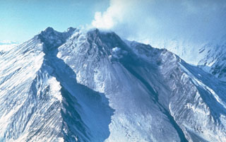
Figures 13-15 show images and photos of Bezymianny that help document the 14 April 2011 eruption, which is also noted in table 5. Several other strong eruptions took place later in the reporting interval (discussed below).
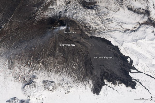 |
Figure 13. A natural-color EO-1 satellite image of Bezymianny acquired 22 April 2011 showing evidence of the size of the 14 April eruption. Dark volcanic deposits (likely a combination of pyroclastic flows and lahars) extend more than 7.3 km SW into valleys. A light-colored plume of ash, steam, and SO2 rises above the summit and drifts W. Volcanic ash covers the upper slopes of the volcano, especially to the S and W. White snow, still deep in late April, blankets the surrounding landscape as seen in figure 15. These images were acquired on 22 April 2011 by the Advanced Land Imager (ALI) aboard the Earth Observing-1 (EO-1) satellite. Caption and figure courtesy of Jesse Allen and Robert Simmons, NASA Earth Observatory. |
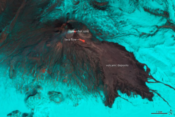 |
Figure 14. Bezymianny, as captured 22 April 2011 in an EO-1 false-color satellite image. At the summit, a red hot spot indicates where fresh lava extruded to the growing lava dome. To the SE, an active lava flow appears as a similar hot spot. In these wavelengths, bare rock and ash are gray; snow and ice appear cyan. These images were acquired near noon on 22 April 2011 by the Advanced Land Imager (ALI) aboard the Earth Observing-1 (EO-1) satellite. Caption and figure courtesy of Jesse Allen and Robert Simmons, NASA Earth Observatory. |
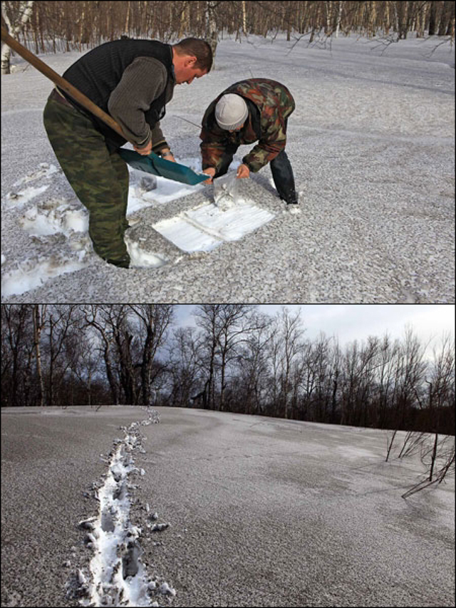 |
Figure 15. Photographs depicting the ash from the 14 April 2011 eruption of Bezymianny mantling the snow base. Courtesy of KVERT. |
On 8 March 2012, KVERT raised Bezymianny's Aviation Color Code to Red after a sharp and sustained increase in seismic activity. KVERT also noted a significant increase in both the size and temperature of a thermal anomaly at the summit, suggesting that new, hot magma was very close to or at the dome's surface. Therefore, the organization suggested that "strong ash explosions up to 13 km a.s.l. were possible at any time during the next 24 hours." The following day, 9 March, Bezymainny exploded; the magnitude of the volcanic tremor was 7.52 m/s. Ash plumes from pyroclastic flows rose to 8 km in altitude and drifted NE. According to later satellite data, the ash plume was distinguishable for ~700 km. In addition, gas-and-steam plumes containing ash rose to an altitude of 3.5-4.0 km and drifted NE. Seismologists reported that the explosion did not pose a threat to population centers in the area. After the strong explosive phase, the eruptive vigor decreased gradually and continued at a low level. Following the 8-9 March event, KVERT lowered the Aviation Color Code to Orange.
During 9-13 March, video captured strong gas-and-steam emissions; no ash was noted. Strong degassing accompanied the effusion of a viscous lava flow on the S flank of the lava dome, along with moderate-to-strong gas-and-steam emissions. Seismic activity was low after 10 March, although the volcano emitted gas-and-steam plumes during 14-15 March. Satellites continued to record thermal anomalies. KVERT lowered the Aviation Color Code to Yellow.
According to visual observations during 15-16 March, the length of the 8 March 2012 pyroclastic deposits was ~4 km. According to satellite data, a thermal anomaly continued to register at the volcano on 23 and 25-26 March. Clouds obscured the volcano on other days of week.
The viscous lava flow continued to effuse on the S flank of the lava dome, accompanied by degassing, well into May. KVERT noted thermal anomalies (detected by satellite) during 29-31 March, 3-4, 9-10, 13-17, 19, 28-29 April, and 3 May. Seismic activity remained low.
According to KVERT, seismicity increased during the middle of August 2012. On 28 August, 17 events were recorded; on 31 August, 71 events were detected. Observers noted weak-to-moderate fumarolic activity during 25-26 and 29 August; cloud cover prevented observations on other days. A thermal anomaly was detected in satellite imagery on 25 August.
On 2 September, an explosion sent ash plumes to an altitude of 10-12 km; plumes drifted more than 1,500 km ENE. A thermal anomaly observed in satellite imagery was very bright before the explosion. The Aviation Color Code was raised to Orange, then Red. Later that day, ash plumes rose to an altitude of 4 km and drifted NE before ash emissions ceased. The Aviation Color Code was then lowered to Yellow. On 3 September seismic activity was low, while a viscous lava flow effused on the lava-dome flank, accompanied by fumarolic activity and hot avalanches.
References. Grapenthin, R., Freymueller, J.T., and Serovetnikov, S., 2010. The December 2009 and May 2010 eruptions of Bezymianny volcano, Kamchatka: Interpretation of the GPS Record, American Geophysical Union, Fall Meeting 2010, abstract #V33D-04.
Izbekov, P.E., Neill, O.K., Shipman, J.S., Turner, S.J., Shcherbakov, V.D., and Plechov, P., 2010. Silicic Enclaves in Products of 2009-2010 Eruptions of Bezymianny Volcano, Kamchatka: Implications for Magma Processes, American Geophysical Union, Fall Meeting 2010, abstract #V33D-01.
Serovetnikov, S., Freymueller, J.T., Titkov, N., Bahtiarov, V., and Senyukov, S,2010. GPS Monitoring Bezimyany Volcano 2006-2010 (Kamchatka), American Geophysical Union, Fall Meeting 2010, abstract #V21B-2325.
Geological Summary. The modern Bezymianny, much smaller than its massive neighbors Kamen and Kliuchevskoi on the Kamchatka Peninsula, was formed about 4,700 years ago over a late-Pleistocene lava-dome complex and an edifice built about 11,000-7,000 years ago. Three periods of intensified activity have occurred during the past 3,000 years. The latest period, which was preceded by a 1,000-year quiescence, began with the dramatic 1955-56 eruption. This eruption, similar to that of St. Helens in 1980, produced a large open crater that was formed by collapse of the summit and an associated lateral blast. Subsequent episodic but ongoing lava-dome growth, accompanied by intermittent explosive activity and pyroclastic flows, has largely filled the 1956 crater.
Information Contacts: Kamchatka Volcanic Eruptions Response Team (KVERT), Institute of Volcanology and Seismology (IV&S) Far East Division, Russian Academy of Sciences (FEDRAS), Kamchatka Branch of the Geophysical Service of the Russian Academy of Sciences (KBGS RAS), Piip Ave. 9, Petropavlovsk-Kamchatsky, 683006, Russia (URL: http://www.kscnet.ru/ivs/, http://www.emsd.ru/~ssl/monitoring/main.htm); Sergei Ushakov, IVS FED RAS; Tokyo Volcanic Ash Advisory Center (VAAC), Tokyo, Japan (URL: http://ds.data.jma.go.jp/svd/vaac/data/); Alaska Volcano Observatory (AVO), a cooperative program of the U.S. Geological Survey, the University of Alaska’s Geophysical Insitute, and the Alaska Division of Geological & Geophysical Surveys (URL: http://www.avo.alaska.edu/); Anchorage Volcanic Ash Advisory Center (VAAC), Alaska Aviation Weather Unit, NWS NOAA US Dept of Commerce, 6930 Sand Lake Road, Anchorage, AK 99502-1845 (URL: http://www.ssd.noaa.gov/).