Report on Axial Seamount (Undersea Features) — October 2012
Bulletin of the Global Volcanism Network, vol. 37, no. 10 (October 2012)
Managing Editor: Richard Wunderman.
Axial Seamount (Undersea Features) New reports on April 2011 eruption
Please cite this report as:
Global Volcanism Program, 2012. Report on Axial Seamount (Undersea Features) (Wunderman, R., ed.). Bulletin of the Global Volcanism Network, 37:10. Smithsonian Institution. https://doi.org/10.5479/si.GVP.BGVN201210-331021
Axial Seamount
Undersea Features
45.95°N, 130°W; summit elev. -1410 m
All times are local (unless otherwise noted)
William Chadwick recently notified Bulletin editors of three new papers concerning the April 2011 eruption of Axial Seamount: Caress and others, 2012; Chadwick and others, 2012; and Dziak and others, 2012. This eruption, recorded by in situ monitoring instruments (ocean bottom pressure recorders and hydrophones), took place during 6-12 April 2011 (BGVN 36:07) and resulted in an erupted volume of lava calculated by bathymetric remapping of 99 x 106 m3 (Chadwick and others, 2012). The activity took place at the S end of the caldera and the S rift zone (figure 9).
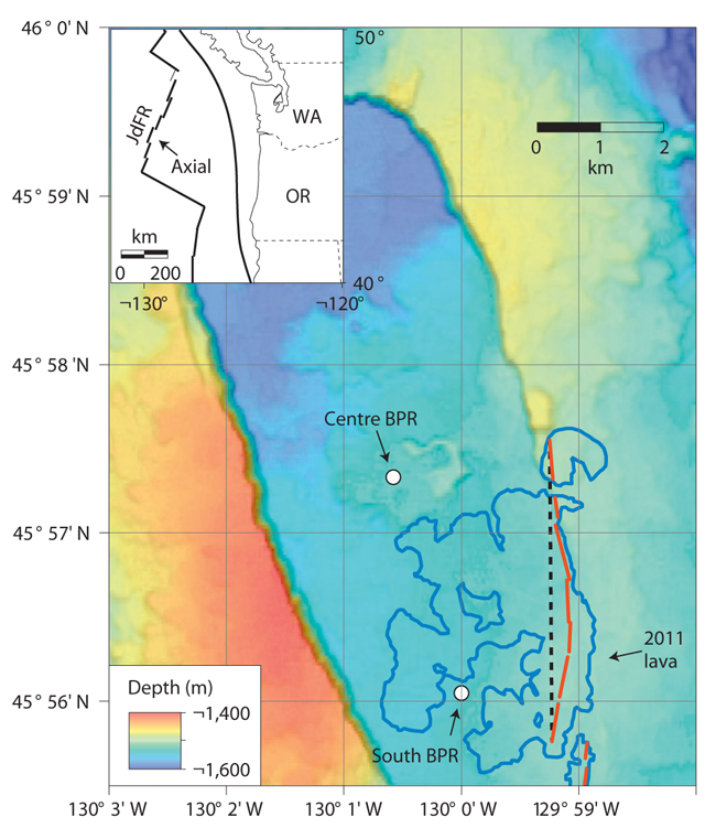 |
Figure 9. Bathymetric map of the summit caldera of Axial Seamount, its rim forming an oval feature elongated NNW-SSE. The insert shows the location of the seamount relative to the W coast of the United States (JdFR, Juan de Fuca Ridge; WA, Washington state; OR, Oregon state). The locations of the two bottom pressure recorders (BPRs) that measured vertical movements of the sea floor during the 2011 eruption are shown, along with the lava flows that were erupted in April 2011 (heavy blue outlines) and their eruptive vents (red lines) (from Caress and others, 2012). The black dashed line shows the location of the model dyke (3.3 km x 2.0 km x 1.0 m) that can reproduce the pre-eruption uplift observed at the BPRs. Courtesy of Chadwick and others, 2012. |
The first recorded eruption of Axial Seamount occurred during 25-31 January 1998 (BGVN 23:01, 23:02) with a lava volume estimated by Chadwick to be 29 x 106 m3. Chadwick noted that he was currently preparing a paper detailing the 1998 eruption that may result in a revision of the lava volume from that event.
References. Caress, D.W., Clague, D.A., Paduan, J.B., Martin, J.F., Dreyer, B.M., Chadwick Jr., W.W., Denny, A., and Kelley, D.S., 2012, Repeat bathymetric surveys at 1-metre resolution of lava flows erupted at Axial Seamount in April 2011, Nature Geoscience, v. 5, p.483-488 (DOI: 10.1038/NGEO1496).
Chadwick Jr., W.W., Nooner, S.L., Butterfield, D.A., and Lilley, M.D., 2012, Seafloor deformation and forecasts of the April 2011 eruption at Axial Seamount, Nature Geoscience, v. 5, p.474-477 (DOI: 10.1038/NGEO1464).
Dziak, R.P., Haxel1, J.H., Bohnenstiehl, D.R., Chadwick Jr., W.W., Nooner, S.L., Fowler, M.J., Matsumoto, H., and Butterfield, D.A., 2012, Seismic precursors and magma ascent before the April 2011 eruption at Axial Seamount, Nature Geoscience, v. 5, p.478-482 (DOI: 10.1038/NGEO1490).
Geological Summary. Axial Seamount rises 700 m above the mean level of the central Juan de Fuca Ridge crest about 480 km W of Cannon Beach, Oregon, to within about 1,400 m of the ocean surface. It is the most magmatically and seismically active site on the Juan de Fuca Ridge between the Blanco Fracture Zone and the Cobb offset. The summit is marked by an unusual rectangular-shaped caldera (3 x 8 km) that lies between two rift zones and is estimated to have formed about 31,000 years ago. The caldera is breached to the SE and is defined on three sides by boundary faults of up to 150 m relief. Hydrothermal vents with biological communities are located near the caldera fault and along the rift zones. Hydrothermal venting was discovered north of the caldera in 1983. Detailed mapping and sampling efforts have identified more than 50 lava flows emplaced since about 410 CE (Clague et al., 2013). Eruptions producing fissure-fed lava flows that buried previously installed seafloor instrumentation were detected seismically and geodetically in 1998 and 2011, and confirmed shortly after each eruption during submersible dives.
Information Contacts: William W. Chadwick, NOAA and Oregon State University.