Report on Akan (Japan) — December 2012
Bulletin of the Global Volcanism Network, vol. 37, no. 12 (December 2012)
Managing Editor: Richard Wunderman.
Akan (Japan) Relatively quiet during 2009-2012
Please cite this report as:
Global Volcanism Program, 2012. Report on Akan (Japan) (Wunderman, R., ed.). Bulletin of the Global Volcanism Network, 37:12. Smithsonian Institution. https://doi.org/10.5479/si.GVP.BGVN201212-285070
Akan
Japan
43.384°N, 144.013°E; summit elev. 1499 m
All times are local (unless otherwise noted)
Although Akan is the most active volcano on the island, little activity has been reported by JMA since November 2008; activity during 2008 was summarized in two previous Bulletins (BGVN 33:10 and 35:10). Since then quiet prevailed except for a few instances of tremor in 2009 and 2010 reported in Japan Meteorology Agency's (JMA) monthly summaries from September 2010 to November 2012. The caldera is located in Akan National Park on the island of Hokkaido, Japan (figure 11).
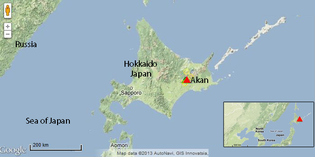 |
Figure 11. The location of the Akan volcano complex (a caldera with multiple cones) on the Japanese island of Hokkaido. Courtesy of Google Maps. |
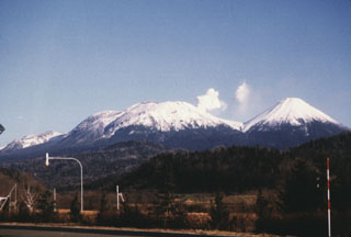
The Me-Akan volcano group, E of Lake Akan, is the only site of historical activity in Akan caldera. Me-Akan is composed of 9 overlapping cones; the main cone contains three prominent craters, the Akanuma crater, 96-1 crater, and "old crater" (figure 12).
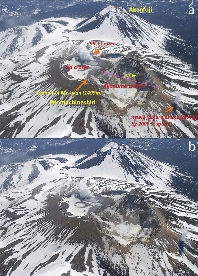 |
Figure 12. An aerial photo taken on 17 April 2009 looking from the N of the Me-Akan cones. (a) The main Me-Akan cone hosts three craters (labled in red): 96-1 crater, steaming in the upper center; below it to the left, old crater; and adjacent to old crater to the right, Akanuma crater. (b) The same image without captions. Courtesy of Keiji Wada and JMA. |
JMA monitors the Akan complex, reporting eruptions, seismicity, and topographic change. A single seismic anomaly was discussed in the December 2010 monthly report (the latest report on Akan as of February 2013):
"Tremors with small amplitudes were observed four times from 12am to 10pm on 17 December [2010]. No remarkable changes in plume, infrasonic and tilt data were observed during the occurrence of these tremors. The previous tremor was observed on 18 March 2009. Seismic activity has returned to the background level, after a temporal increase of volcanic earthquakes with small amplitude during 17 December through 19 December. According to the observation by Kakioka Magnetic Observatory of JMA, geomagnetic total intensity at Meakandake [Akan] has been increasing since July 2009, which reflects the cooling process beneath the south slope of 96-1 crater, and its trend has been declining since July 2010. No remarkable changes in both plume activity and crustal deformation were observed."
Since the Me-Akan complex, part of a 13 X 24 km elongated caldera, lies within the Akan National Park (figure 13), JMA not only monitors the complex, but as well produced safety and evacuation procedures for the visitors. The JMA prepared both a hazard alert map (figure 14), and volcano hazard and evacuation procedure poster (figure 15). These are available at Lake Akan and Lake Kussharo-ko, hot springs, nature sites, and accommodations. Figures 14 and 15 meet the needs of those visitors unfamiliar with the nature of volcanoes, hot springs and calderas. In the form of a cartoon (infographics), the latter helps those with little or no knowledge of the Japanese language.
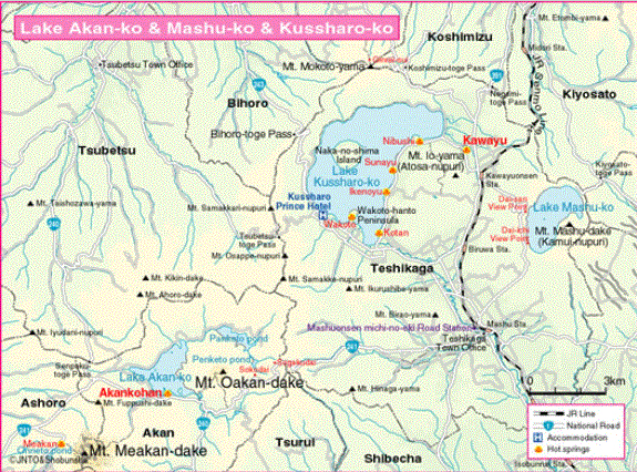 |
Figure 13. Akan volcano on Mt. Me-Akan (Mt. Meakan-dake). Note Lake Akan (Lake Akan-ko), roads, rail lines, and density of tourist facilities and travel near the volcano complex. Courtesy of Secret-Japan.com. |
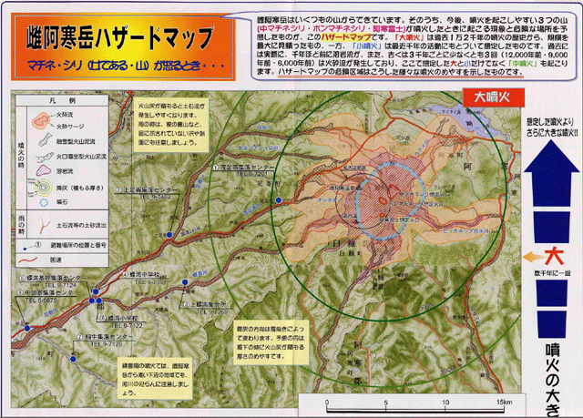 |
Figure 14. JMA hazard map for the active Me-Akan cone (in Japanese). Courtesy of JMA. |
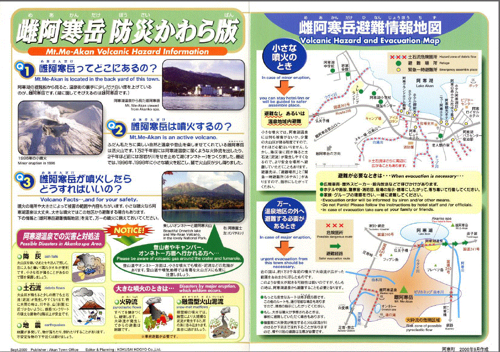 |
Figure 15. JMA cartoon of Akan volcano hazard and evacuation information (chiefly in Japanese with several English translations). Courtesy of JMA. |
Geological Summary. Akan is a 13 x 24 km caldera located immediately SW of Kussharo caldera. The elongated, irregular outline of the caldera rim reflects its incremental formation during major explosive eruptions from the early to mid-Pleistocene. Growth of four post-caldera stratovolcanoes, three at the SW end of the caldera and the other at the NE side, has restricted the size of the caldera lake. Conical Oakandake was frequently active during the Holocene. The 1-km-wide Nakamachineshiri crater of Meakandake was formed during a major pumice-and-scoria eruption about 13,500 years ago. Within the Akan volcanic complex, only the Meakandake group, east of Lake Akan, has been historically active, producing mild phreatic eruptions since the beginning of the 19th century. Meakandake is composed of nine overlapping cones. The main cone of Meakandake proper has a triple crater at its summit. Historical eruptions at Meakandake have consisted of minor phreatic explosions, but four major magmatic eruptions including pyroclastic flows have occurred during the Holocene.
Information Contacts: Japan Meteorological Agency (JMA), Otemachi, 1-3-4, Chiyoda-ku Tokyo 100-8122, Japan (URL: http://www.jma.go.jp/); Keiji Wada, Hokkaido University of Education, Hokumon-cho 9, Asahikawa 070-8621, Japan; Google Maps (URL: http://maps.google.com/); Secret-Japan.com (URL: http://www.secret-japan.com/).