Report on Tolbachik (Russia) — December 2012
Bulletin of the Global Volcanism Network, vol. 37, no. 12 (December 2012)
Managing Editor: Richard Wunderman.
Edited by Robert Dennen.
Tolbachik (Russia) Seismicity precedes onset of dual fissure eruption in November 2012
Please cite this report as:
Global Volcanism Program, 2012. Report on Tolbachik (Russia) (Dennen, R., and Wunderman, R., eds.). Bulletin of the Global Volcanism Network, 37:12. Smithsonian Institution. https://doi.org/10.5479/si.GVP.BGVN201212-300240
Tolbachik
Russia
55.832°N, 160.326°E; summit elev. 3611 m
All times are local (unless otherwise noted)
Nearly 36 years after its last eruption, the largest basaltic eruption in Kamchatka during historic times (1975/76 eruptions; CSLP 51-75; SEAN 01:07, 01:08), Tolbachik (figure 1) began erupting again on 27 November 2012 following almost three weeks of episodic volcanic tremor. The eruption emerged as two fissures along the W side of Tolbachinsky Dol (a lava plateau along the SW flank of Tolbachik), in the same area as the northern vents of the 1975/76 eruptions. The eruption produced both effusive lava flows and explosions that generated low-level ash-bearing plumes.
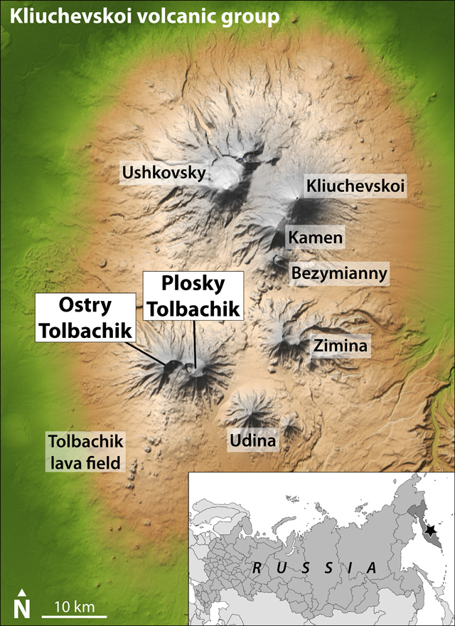 |
Figure 1. Shuttle Radar Topography Mission (SRTM) colored elevation and shaded relief map highlighting the location of Tolbachik at the S end of the Kliuchevskoi (Kliuchevskaya) volcanic group, Kamchatka Peninsula, Russia (inset shows regional setting, with the Kamchatka peninsula highlighted in dark gray at the top right, and the location of the Kliuchevskoi volcanic group indicated by the star). Tolbachik comprises the flat-topped Plosky Tolbachik shield volcano (and its nested calderas) to the E and the sharp-topped Ostry Tolbachik stratovolcano to the W. SRTM map modified from NASA Jet Propulsion Laboratory; inset regional map modified from Wikipedia. |
This report mainly summarizes Kamchatkan Volcanic Eruption Response Team (KVERT) daily and weekly reports and information releases concerning the ongoing (as of early February 2013) Tolbachik fissure eruption.
Seismicity preceding 27 November 2012 eruption. Episodic tremor was recorded at Tolbachik during 7-10, 18, and 26 November 2012; KVERT noted a distinct difference between these episodes of tremor and discrete events that had occurred over "many years" prior. Shallow volcanic earthquakes began on 26 November, increasing in number to ~267 through 27 November. The Aviation Color Code was raised from Green to Yellow (on a scale increasing from Green-Yellow-Orange-Red) on 27 November. In a daily report discussing activity on 27 November, KVERT reported that shallow events, possibly indicating ash explosions, had occurred during 1715-2000. The Kamchatka Branch of the Geophysical Service of the Russian Academy of Sciences (KB GS RAS) reported a strong seismic event at 1752 that day. Informed by KB GS RAS, the Tokyo Volcanic Ash Advisory Center (VAAC) posted a volcanic ash advisory at 1837 (table 1). The ash explosions prompted KVERT to raise the Aviation Color Code to Orange. Continuos tremor occurred for the rest of the day, indicating possible lava flows.
Table 1. Summary of Tokyo VAAC volcanic ash (VA) advisories for Tolbachik during November 2012-January 2013. Plume heights are reported in km above sea level (a.s.l.); '-' indicates data not reported. Note that the fissures are at approximately 1,600-1,700 m elevation, and not at the summit (3,682 m elevation), thus complicating plume height estimates. Yelizovo Airport is indicated as a data source by its airport code, UHPP. All times are local (UTC - 12 hours). Courtesy of Tokyo VAAC.
| Date | Time | Plume Altitude (km) | Drift Direction | Remarks (data source) |
| 27 Nov 2012 | 1837 | 6.1 | -- | Eruption reported at 1715 (KB GS RAS) |
| 27 Nov 2012 | 2313 | 10.05 | NNW | Eruption (KB GS RAS) |
| 29 Nov 2012 | 1003 | 3.95 | N | VA reported (UHPP) |
| 29 Nov 2012 | 1500 | 3.65 | SE | VA reported (KVERT) |
| 29 Nov 2012 | 1746 | 3.95 | SE | Continuing emissions (satellite imagery) |
| 29 Nov 2012 | 2355 | 3.95 | SE | Continuing emissions (satellite imagery) |
| 30 Nov 2012 | 0600 | 3.95 | N | Continuing emissions (satellite imagery) |
| 30 Nov 2012 | 1152 | -- | -- | VA dissipated on imagery (satellite imagery) |
| 30 Nov 2012 | 1634 | NVA reported (UHPP) | ||
| 03 Dec 2012 | 2138 | 4.25 | NW | VA reported (UHPP) |
| 05 Dec 2012 | 1221 | 4.25 | SE | VA reported (KVERT) |
| 07 Dec 2012 | 1431 | 4.25 | SW | VA reported (KVERT) |
| 13 Dec 2012 | 1139 | 3.05 | NE | VA reported (KVERT) |
| 13 Dec 2012 | 1232 | 4.55 | E | VA reported (UHPP) |
| 14 Dec 2012 | 1209 | 3.05 | NE | VA reported (KVERT) |
| 27 Dec 2012 | 1126 | 5.2 | SE | VA reported (UHPP) |
| 07 Jan 2013 | 1145 | 3.65 | NE | VA reported (KVERT) |
| 07 Jan 2013 | 1202 | 4.25 | NE | VA reported (KVERT) |
Observations reveal two fissure vents. By the early morning of 28 November 2012, observers in Kozyrevsk (~40 km NW) and Lazo (~50 km SW) had reported periodic incandescence from Tolbachik during the night. Later that morning, observers in the same locations reported ash explosions and lava flows in the area of the northern vents of the 1975/76 eruptions, along the W side of Tolbachinsky Dol.
The first available photograph of the eruption showed that lava was issuing through two fissures (figure 2). Ashfall 4-cm-deep was reported in Krasny Yar (~60 km NNW) by midday on 28 November (figure 3). According to a KVERT information release, the Aviation Color Code was raised to Red for a brief period on 29 November, but this was not reflected in the daily reports; the Aviation Color Code remained Orange for the remainder of the reporting interval.
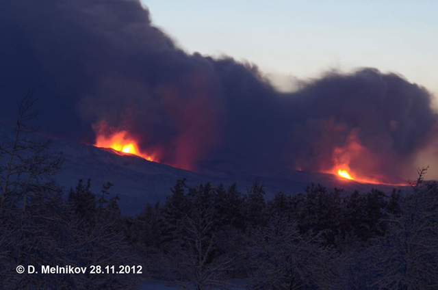 |
Figure 2. The first available photograph of the Tolbachik dual fissure eruption that began on 27 November 2012. Fire fountaining through two fissure vents are seen generating ash plumes that reached ~3 km above sea level on 28 November 2012. Courtesy of Dmitry Melnikov (IVS FED RAS) and KVERT. |
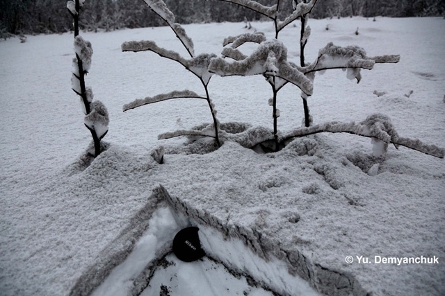 |
Figure 3. Ashfall from Tolbachik was reported in Krasny Yar (~60 km NNW). Two deposits are distinguishable, separated by fresh snowfall; lens cap for scale. Courtesy of Y. Demyanchuk (IVS FED RAS) and KVERT. |
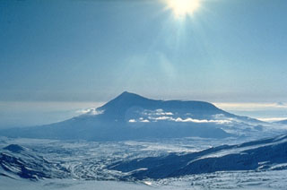
KVERT reported on 28 November that the N and S fissures were located 4-5 km and 6-7 km S of Plosky Tolbachik, respectively. Plosky Tolbachik is a shield volcano with nested summit calderas that makes up the E half of Tolbachik; the W portion of Tolbachik is the sharply-peaked Ostry Tolbachik stratovolcano (figures 1 and 4). At that time, Strombolian activity (figure 5) was observed at 4-5 vents in the N fissure and 2-3 vents in the S fissure; the very fluid lavas (figure 6) were flowing, often in 'lava rivers', to the W side of Tolbachinsky Dol (figure 7), and KVERT noted a large thermal anomaly over the N part of Tolbachinsky Dol (figure 8). Observers reported booming noises and vibrating windowpanes.
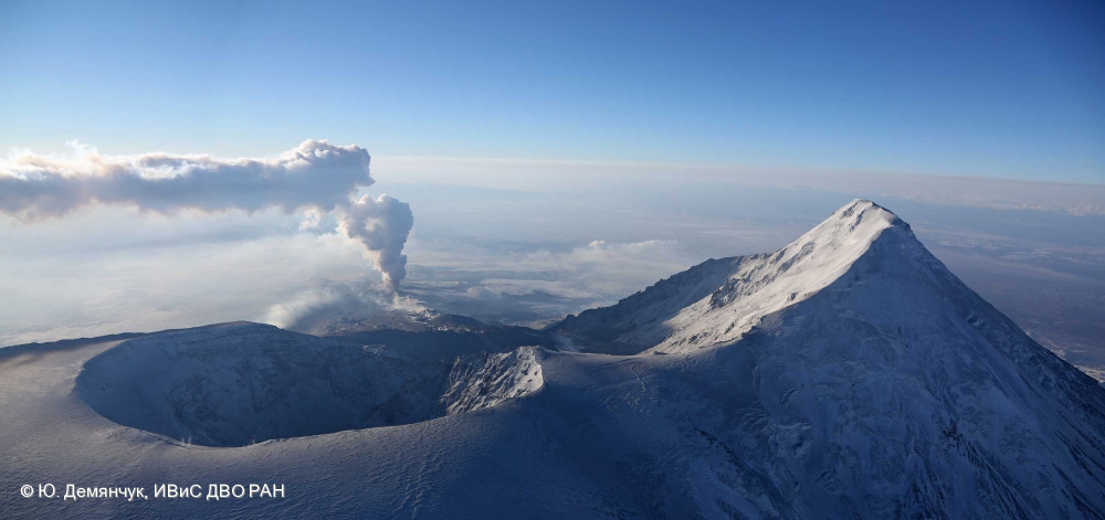 |
Figure 4. Tolbachik viewed from the NNE on 13 December 2012, showing Plosky Tolbachik, the shield volcano, and its large, nested summit calderas on the left (E) and Ostry Tolbachik, the sharply peaked stratovolcano on the right (W). An E-drifting plume is seen rising from the fissure eruption on Tolbachinsky Dol to the S (in the background). Courtesy of Y. Demyanchuk (IVS FEB RAS) and KVERT. |
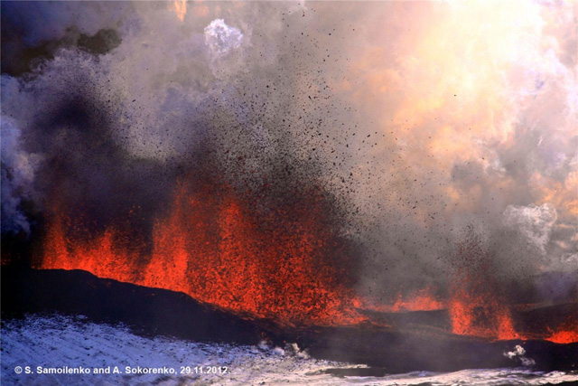 |
Figure 5. Strombolian activity during the eruption from the S fissure of Tolbachinsky Dol on 29 November 2012. Courtesy of S. Samoilenko and A. Sokorenko (IVS FEB RAS) and KVERT. |
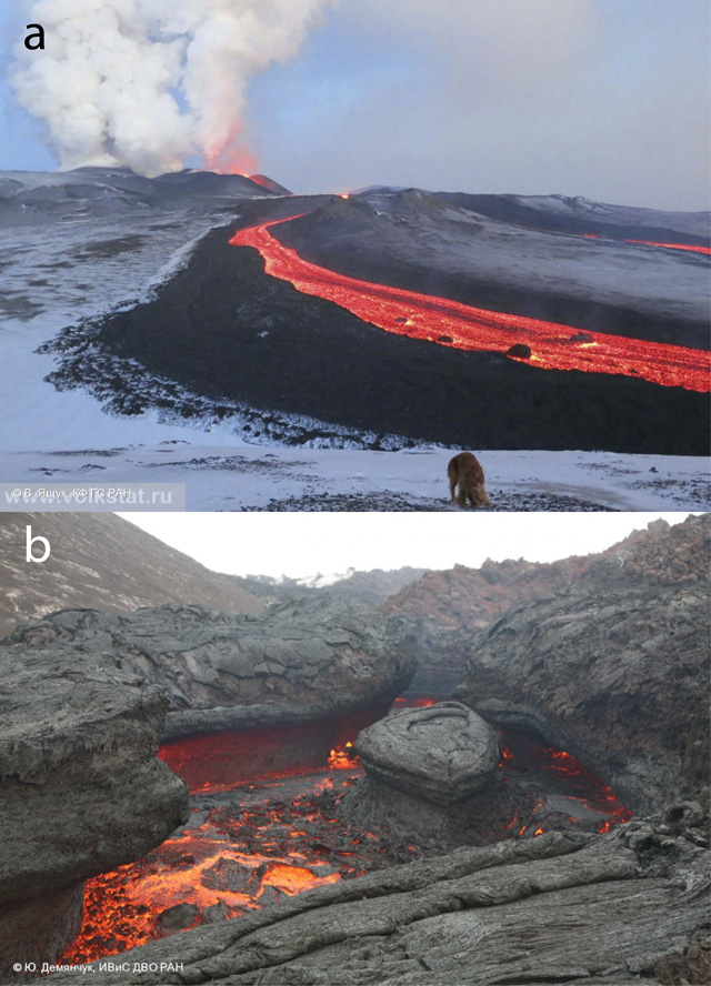 |
Figure 6. Photographs highlighting the very fluid nature of lavas effused from the fissure eruption of Tolbachinsky Dol. (a) Fluid lavas from the S fissure of Tolbachinsky Dol flowing in a 'lava river' on 6 December 2012. A dog is in the foreground for scale. Courtesy of V. Yaschuk (KB GS RAS) and KVERT. (b) A 'lava river', presumably effused from the S fissure, flowing around a 'lava island' on 23 January 2013. Courtesy of Y. Demyanchuk (IVS FEB RAS) and KVERT. |
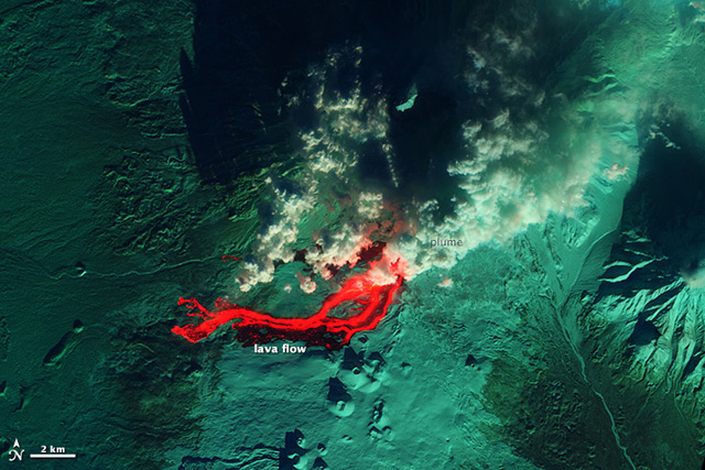 |
Figure 7. A false color infrared satellite image showing lava flowing W from the fissure eruption of Tolbachinsky Dol; snow appears green in this image. The fissure vents are hidden behind the plume in the N part of the image. To the S of the lava flow are cinder cones from the 1975/76 eruption of Tolbachik. The image was collected on 1 December 2012 by the Advanced Land Imager on the Earth Observing-1 Satellite; courtesy of NASA Earth Observatory. |
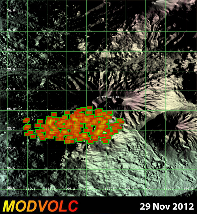 |
Figure 8. A MODVOLC thermal alert image for 29 November 2012 showing a large thermal anomaly over the N portion of Tolbachinsky Dol, resulting from the eruption of lava through two fissure vents. This image is a combination of multiple pixel alerts registered at 7 different times during the same day. Courtesy of the Hawai`i Institute of Geophysics and Planetology (HIGP) Thermal Alerts System. |
On 29 November, seismicity declined, and KVERT characterized the eruption as effusive; renewed seismicity occurred the next day, and a gas-and-steam plume with small amounts of ash rising to ~3 km was reported. Lava flows from the N fissure destroyed two scientific base camps located ~10 km from Tolbachik.
Cinder cones grow on S fissure; new fumarole. A KVERT weekly report issued on 6 December 2012 noted that cinder cones were growing on the S fissure, and that lava effused from the S fissure had flowed up to 20 km away by 7 December. A fumarole was observed at the bottom of the Plosky Tolbachik caldera on 8 December (figure 9); this was the first fumarole observed in the caldera in ~30 years. On 9 December KVERT daily reports began stating that the effusion of lava was continuing from the S fissure, no longer mentioning the N fissure.
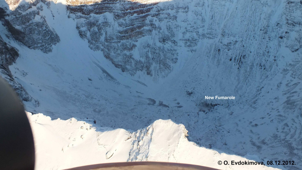 |
Figure 9. A new fumarole that was observed in the Plosky Tolbachik caldera on 8 December 2012. KVERT reported that this is the first fumarole in the caldera in ~30 years. Courtesy of O. Evdokimova (IVS FEB RAS) and KVERT. |
By the end of December, KVERT reported that five cinder cones were growing on the S fissure (e.g. figure 10); by 10 January 2013, however, KVERT reported only four cinder cones on the S fissure.
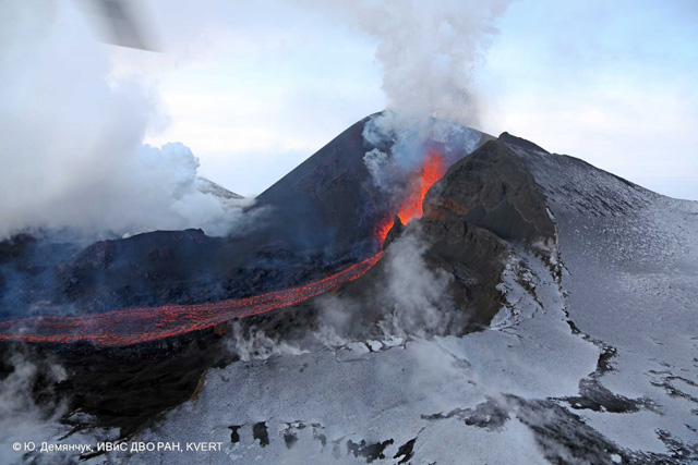 |
Figure 10. Strombolian activity within a cinder cone on the S fissure of Tolbachinsky Dol on 27 December 2012. The strombolian activity is feeding a lava river, flowing to the left. Courtesy of Y. Demyanchuk (IVS FEB RAS) and KVERT. |
As of early February 2013, the eruption continued to produce very fluid lava flows, four growing cinder cones, gas-and-steam plumes with variable ash contents that often reached ~4 km a.s.l. and drifted in various directions, and daily thermal alerts above Tolbachinsky Dol. Two examples of eruptive products from the eruption are shown in figure 11.
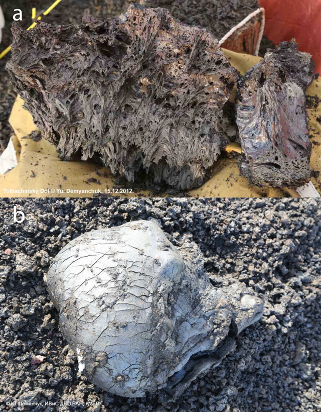 |
Figure 11. Examples of eruptive products from the fissure eruption of Tolbachik that began on 27 November 2012 (ongoing as of early February 2013). (a) Vesicular lava sample (of unspecified dimensions and source location) photographed on 15 December 2012, displaying a very fluidal texture. (b) A volcanic bread-crust bomb photographed in situ (unspecified dimensions and source location) on 24 January 2013. Courtesy of Y. Demyanchuk (IVS FEB RAS) and KVERT. |
Geological Summary. The massive Tolbachik volcano is located at the southern end of the Kliuchevskaya volcano group. The massif is composed of two overlapping, but morphologically distinct, volcanoes. The flat-topped Plosky Tolbachik shield volcano with its nested Holocene calderas up to 3 km in diameter is located east of the older and higher sharp-topped Ostry Tolbachik stratovolcano. The summit caldera at Plosky Tolbachik was formed in association with major lava effusion about 6,500 years ago and simultaneously with a major southward-directed sector collapse of Ostry Tolbachik. Long rift zones extending NE and SSW of the volcano have erupted voluminous basaltic lava flows during the Holocene, with activity during the past two thousand years being confined to the narrow axial zone of the rifts. The 1975-76 eruption originating from the SSW-flank fissure system and the summit was the largest historical basaltic eruption in Kamchatka.
Information Contacts: Kamchatkan Volcanic Eruption Response Team (KVERT), Institute of Volcanic Geology and Geochemistry, Piip Ave. 9, Petropavlovsk-Kamchatsky, 683006, Russia; Tokyo Volcanic Ash Advisory Center (VAAC), Tokyo, Japan (URL: http://ds.data.jma.go.jp/svd/vaac/data/); Kamchatka Branch of the Geophysical Service of the Russian Academy of Sciences (KB GS RAS), Piip Ave. 9, Petropavlovsk-Kamchatsky, 683006, Russia; Yelizovo Airport (UHPP), Petropavlovsk-Kamchatsky, Kamchatka Krai, Russia; NASA Earth Observatory, NASA Goddard Space Flight Center (URL: http://earthobservatory.nasa.gov/); NASA Jet Propulsion Laboratory, California Institute of Technology (URL: http://www.jpl.nasa.gov/); Wikipedia (URL: http://www.wikipedia.org/).