Report on San Cristobal (Nicaragua) — January 2013

Bulletin of the Global Volcanism Network, vol. 38, no. 1 (January 2013)
Managing Editor: Richard Wunderman.
Edited by Julie A. Herrick.
San Cristobal (Nicaragua) Ash eruption during 25-28 December 2012
Please cite this report as:
Global Volcanism Program, 2013. Report on San Cristobal (Nicaragua) (Herrick, J.A., and Wunderman, R., eds.). Bulletin of the Global Volcanism Network, 38:1. Smithsonian Institution. https://doi.org/10.5479/si.GVP.BGVN201301-344020
San Cristobal
Nicaragua
12.702°N, 87.004°W; summit elev. 1745 m
All times are local (unless otherwise noted)
Our last report highlighted monitoring efforts at San Cristóbal and the explosive eruption that began on 8 September 2012 (BGVN 37:08). By 16 September 2012, seismicity and emissions had decreased; however, the Instituto Nicaragüense de Estudios Territoriales (INETER) announced in late December 2012 that volcanic activity had re-started. In this report, we cover the time period of 25-31 December when seismicity, explosions, and gas-and-ash emissions were reported.
At 2000 on 25 December 2012, observers noted a series of gas-and-ash explosions from the summit. The wind carried the fine- to sand-sized ash SW. Several hours prior to this activity, INETER had reported that seismicity was elevated but sulfur dioxide emissions (SO2) were relatively low compared to measurements from previous days.
During the early hours of the morning on 26 December, winds dispersed fine ash NW, W, and SW. Sand-size ash was fell on the W and SW flanks (figure 28). Civil Defense authorities from the municipality of Chinandega reported an ash plume up to 500 m above the summit and described the event as a "moderate eruption" similar to the 8 September 2012 event.
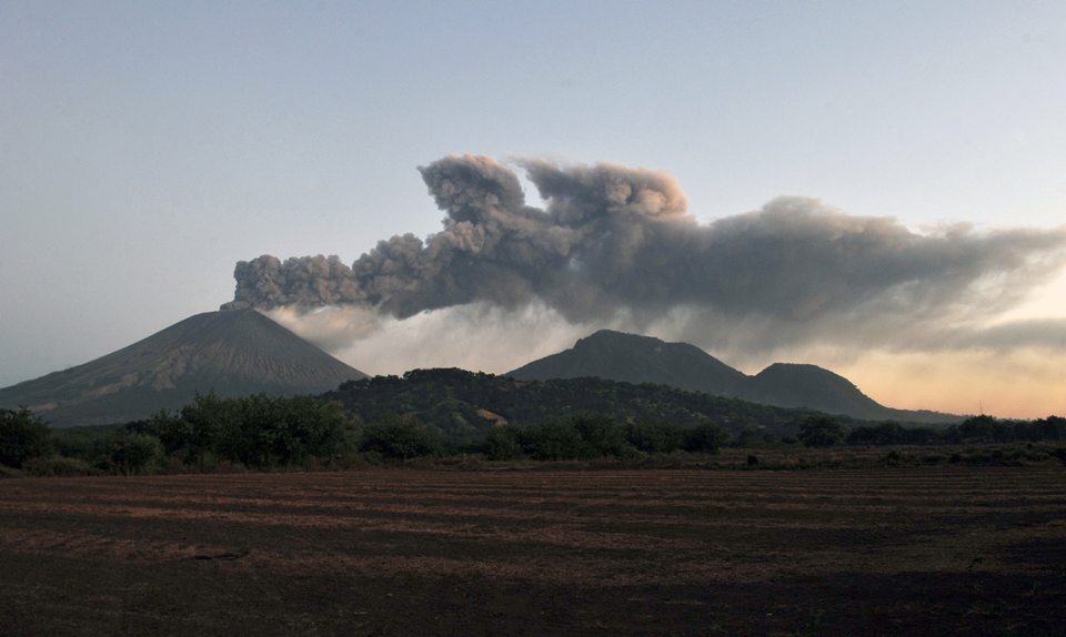 |
Figure 28. A view S toward San Cristóbal with an ash plume drifting westerly on 26 December 2012. The lower hills to the right are part of El Chonco, an older volcanic edifice. Photograph by Hector Retamal, AFP, Getty Images. |
On 26 December, government officials reported to Reuters that local inhabitants were evacuating. Rosario Murillo, a government spokeswoman, called on residents within a 3 km radius of the volcano to leave the area; some families had already self-evacuated.
By 1000 that day, INETER reported that seismicity had increased, and that they had received reports from Civil Defense stating that an eruption of fine ash rose to ~2,500 m above the crater. By the early afternoon, four major seismic events were detected and interpreted as explosions at the summit. Ashfall from these events primarily affected an area within a 5-6 km radius of the summit: El Viejo, Las Rojas, Banderas, Abraham Rugama, and those communities north of Chinandega's urban limit Grecia (particularly two communities called #1 and #4; see figure 19 in BGVN 36:12 for major town locations).
In their second communication on 26 December, INETER suggested that local inhabitants protect their water sources from ashfall, particularly those communities W, SW, and S of the volcano. They also announced that grazing lands would be closed in those regions due to the quantity of ash that had fallen. Research at Raupehu, New Zealand, and elsewhere has found that grazing animals can suffer damage to their teeth and poisoning due to elevated sulfur and fluorine if they consume ash-covered plants (Cronin and others, 2003). Precautions were also recommended for young children who could be adversely affected by inhaling fine ash. INETER noted that aviation traffic had been alerted to the presence of ash in the region.
The Washington Volcanic Ash Advisory Center (VAAC) detected ash from San Cristóbal during 26-28 December. Emissions were ongoing during that time period; plumes rose 2.4-4.3 km a.s.l. and drifted approximately W over the Pacific Ocean as far as 670 km WNW from the summit (figure 29).
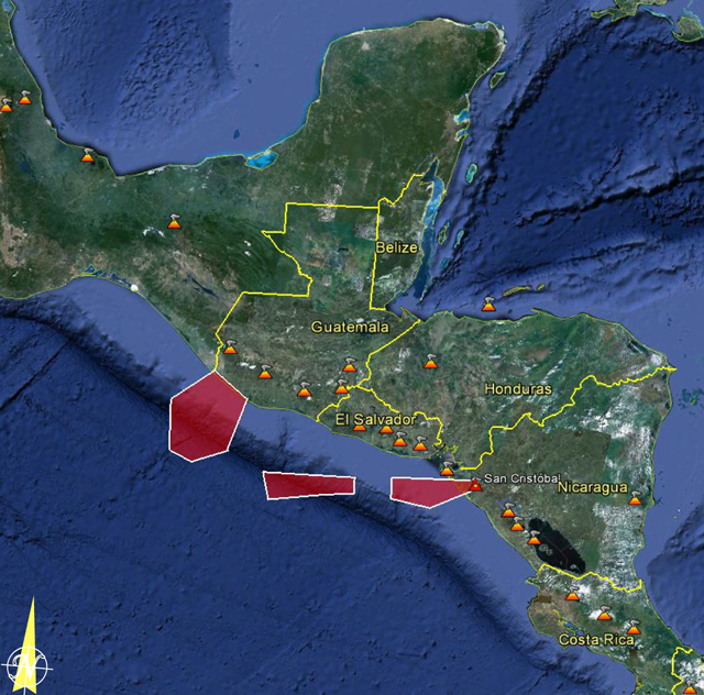 |
Figure 29. The aerial extent of observed volcanic ash from San Cristóbal was concentrated in three discrete regions mainly offshore of Central America at 0430 on 28 December 2012. The red polygons were developed by the VAAC as geospatial files (KML) for display in Google Earth. Courtesy of Washington VAAC and Google Earth. |
INETER reported to local news agencies that 7 of the 13 municipalities of Chinandega were affected by ashfall by 27 December. Visibility was greatly reduced within the urban city of Chinandega. Emissions continued from the summit and reached 200 m above the crater rim in the morning. At the time of their second online notice, a plume of fine ash was visible rising up to 500 m above the crater, and small-to-moderate sized explosions of gas and ash continued.
On 28 December, the minister of Agriculture and Forestry told the local news agency, La Jornada, that while 2 millimeters of ash had fallen in some areas around the volcanic edifice, the farming areas should not be adversely affected since most of the crops had already been harvested. The public utility company, ENACAL, conducted investigations into water quality for the region.
News agencies reported that up to 20 km of highway was affected by ashfall along the Pan-American Highway between Honduras and Nicaragua. Vehicles opted to use headlights due to reduced visibility. La Jornada reported that a total of 268 people had left the area of San Cristóbal by 28 December and 68 were evacuated by the national humanitarian agency (Nicaraguan Humanitarian Rescue Unit, UHR).
INETER reported that small to moderate sized explosions had occurred in the morning of 28 December and a significant increase in SO2 flux was detected. This announcement included warnings regarding eye, skin, and respiratory irritation due to volcanic gases. There were also recommendations regarding ash removal from roofs and structures. Ash was distributed NW, W, and SW from the volcano and satellite images detected ash extending across the Pacific Ocean following the regional airstream offshore of El Salvador.
After an explosion of ash and gas at 1100 on 28 December, emissions throughout the day were ash-poor. Seismicity also decreased that day and, by 29 December, explosions had ceased and diffuse gas emissions continued. In their online bulletin, INETER reported that, as of 31 December, no ash explosions had been detected over the past two days. Gas emissions continued from the summit but SO2 levels had returned to normal.
Volcanic hazards map for San Cristóbal. A map of volcanic hazards was available on the INETER website for the region of San Cristóbal (figure 30). Volcanic ballistics, lahars, landslides, lava flows, and tephrafall were assessed and likely impacted areas were delineated. The tephrafall region corresponded to the prevailing winds and correlated well with ash-effected regions during the December 2012 events.
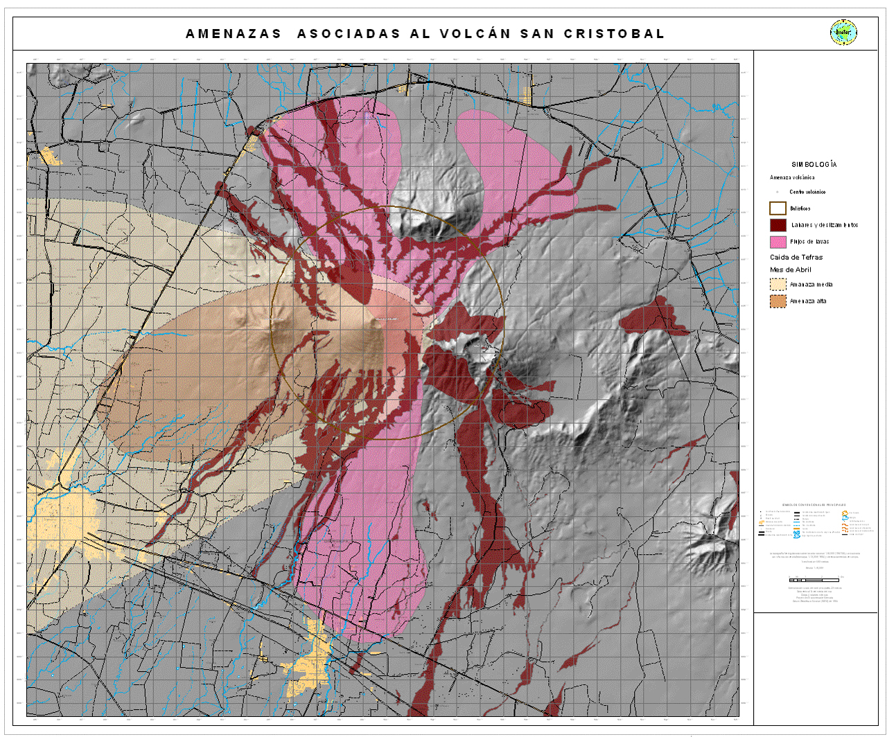 |
Figure 30. Volcanic hazards from San Cristóbal include ejecta, lahars, landslides, and lava flows. This map was released in April 2006 and developed to show the aerial extent of potential events. Densely populated regions are yellow, road systems are black, and rivers are blue; additional color regions correspond to hazards listed in the key (in Spanish). The brown circle has a radius of 5 km and encompasses the main volcanic edifice indicating the maximum expected extent of ballistics (volcanic bombs for example); the two tan regions indicate the extent of possible tephra fall (where lighter shading indicates a medium-level risk zone and darker is higher-level risk); red regions follow major drainages where lahars and landslides could occur; the region shaded pink encompasses the areas most likely effected by future lava flows. Courtesy of INETER. |
Reference. Cronin, S.J., Neall, V.E., Lecointre, J.A., Hedley, M.J., and Loganathan, P., 2003, Environmental hazards of fluoride in volcanic ash: a case study from Ruapehu volcano, New Zealand, Journal of Volcanology and Geothermal Research, 121, 271-291.
Geological Summary. The San Cristóbal volcanic complex, consisting of five principal volcanic edifices, forms the NW end of the Marrabios Range. The symmetrical 1745-m-high youngest cone, named San Cristóbal (also known as El Viejo), is Nicaragua's highest volcano and is capped by a 500 x 600 m wide crater. El Chonco, with several flank lava domes, is located 4 km W of San Cristóbal; it and the eroded Moyotepe volcano, 4 km NE of San Cristóbal, are of Pleistocene age. Volcán Casita, containing an elongated summit crater, lies immediately east of San Cristóbal and was the site of a catastrophic landslide and lahar in 1998. The Plio-Pleistocene La Pelona caldera is located at the eastern end of the complex. Historical eruptions from San Cristóbal, consisting of small-to-moderate explosive activity, have been reported since the 16th century. Some other 16th-century eruptions attributed to Casita volcano are uncertain and may pertain to other Marrabios Range volcanoes.
Information Contacts: Instituto Nicaragüense de Estudios Territoriales (INETER), Apartado Postal 2110, Managua, Nicaragua (URL: http://www.ineter.gob.ni/); Washington Volcanic Ash Advisory Center (VAAC), Satellite Analysis Branch (SAB), NOAA/NESDIS E/SP23, NOAA Science Center Room 401, 5200 Auth Rd, Camp Springs, MD 20746, USA (URL: http://www.ospo.noaa.gov/Products/atmosphere/vaac/); La Jornada (URL: http://www.lajornadanet.com/diario/archivo/2012/diciembre/28/1.php); La Prensa de Nicaragua (URL: http://www.laprensa.com.ni/2012/12/27/ambito/128746/imprimir); Reuters.