Report on Dona Juana (Colombia) — January 2013
Bulletin of the Global Volcanism Network, vol. 38, no. 1 (January 2013)
Managing Editor: Richard Wunderman.
Edited by Julie A. Herrick.
Dona Juana (Colombia) Seismic swarm in 2010 and monitoring efforts
Please cite this report as:
Global Volcanism Program, 2013. Report on Dona Juana (Colombia) (Herrick, J.A., and Wunderman, R., eds.). Bulletin of the Global Volcanism Network, 38:1. Smithsonian Institution. https://doi.org/10.5479/si.GVP.BGVN201301-351070
Dona Juana
Colombia
1.5°N, 76.936°W; summit elev. 4137 m
All times are local (unless otherwise noted)
Doña Juana, a volcano in repose, is located ~50 km NE of Pasto, the provincial capital where the local Instituto Colombiano de Geología y Minería (INGEOMINAS) volcanic and seismic observatory is based (figure 1). In this report we discuss monitoring efforts that began as early as 2004, highlight elevated seismicity detected in mid-2010, and describe the relatively new national park which encompasses Doña Juana and two other volcanic centers (Petacas and Ánimas). Petacas is ~19 km NE of Doña Juana and Ánimas, 12.5 km NE. Ánimas lacks a clear Holocene age; however, Ánimas is an important landmark in this report because the recent seismicity is often found proximal to this volcano. Listed as a Quaternary volcanic center, Ánimas can be found in the "Preliminary List of Pleistocene Volcanoes" section of the Volcanoes of the World 3rd edition (Siebert and others, 2010).
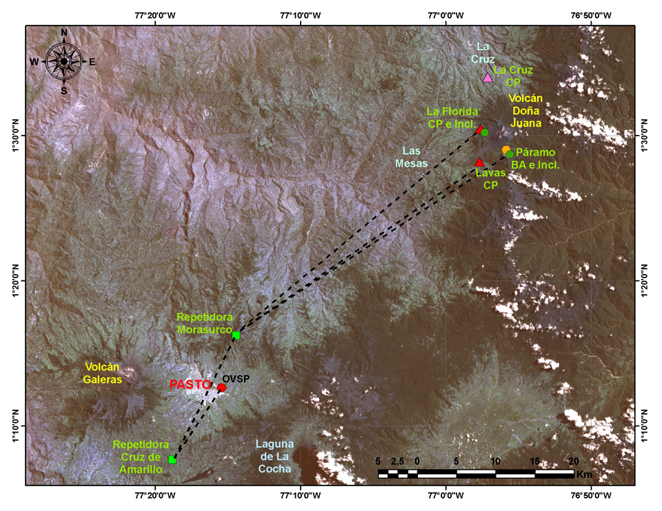 |
Figure 1. This map of instrumentation from 2012 shows the monitoring network for Doña Juana with telemetered locations for the observatory in Pasto (red circle). Triangles are short period seismic stations (red triangles correspond to INGEOMINAS stations and the pink triangle is part of the National Seismic Network of Colombia (RSNC)), the orange hexagon is a broadband seismic station, green circles are electronic tiltmeters, and green squares are repeater stations for telemetry. The volcanic centers of Doña Juana and Galeras are labeled with yellow text. Courtesy of INGEOMINAS. |
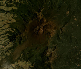
Aerial observations and field investigations. Aerial observations had been collected since 2004 in collaboration with the Colombian Air Force (FAC). Overflights during clear conditions provided views of the lava domes and exposures of bare rock where high elevation and frequent rockfalls limit vegetation (figure 2). Remote sensing images of the region also captured the variations in vegetation and distribution of scree slopes (figure 3).
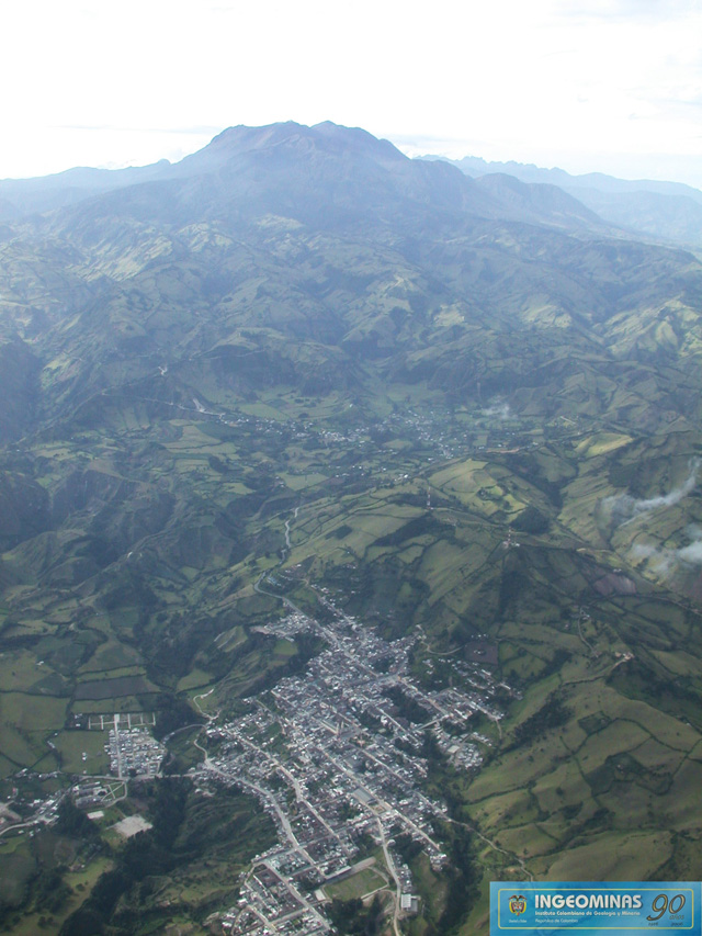 |
Figure 2. This SE looking photo of Doña Juana was taken during aerial surveys on 12 March 2007. The town of La Cruz appears in the foreground, ~13 km W of the volcanic edifice (on the skyline). Courtesy of INGEOMINAS. |
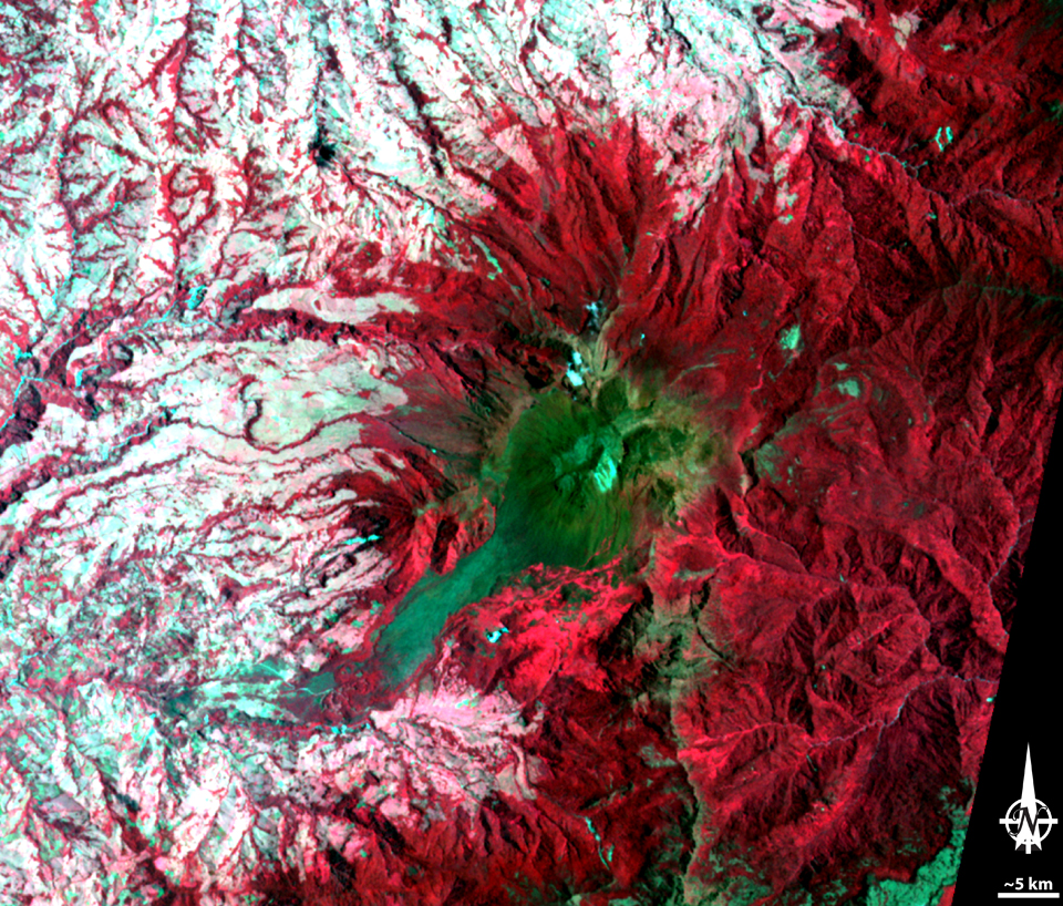 |
Figure 3. This false-color ASTER image of Doña Juana from 9 September 2010 provided a clear view of the sharp boundaries between heavy vegetated outer flanks (red) and the scrub-covered dome complex (green). Within the central dome area a pale region is attributed to scree from rockfalls. The lowlands, where agriculture dominates the topography, can be distinguished by the pale pink to white regions. Courtesy of NASA. |
During 13-21 September 2006, INGEOMINAS led field investigations around Doña Juana. Four scientists focused on the area's stratigraphy and composition of volcanic deposits for development of a future hazard map as well as enhancing the knowledge of the volcano's eruptive history.
Monitoring stations. Three seismic stations were online in 2008: Lava, Florida, and Páramo (figure 4). The Páramo tiltmeter was also online in 2008. In 2009 two additional stations were online; La Cruz seismic station was installed in April and La Florida electronic tiltmeter was installed in June. In 2011, geochemical monitoring began at hot springs within 7 km of the edifice.
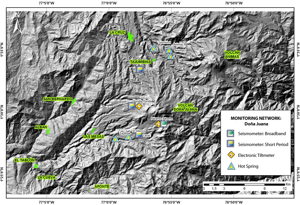 |
Figure 4. The telemetered monitoring network for Doña Juana in 2012 included seismic and electronic tiltmeter instruments. Regular monitoring efforts also included measurements at hot springs (see text). Names of the two volcanic centers Doña Juana and Ánimas and the local communities are highlighted in green. The largest nearby community is the town of La Cruz, ~13 km NNW of the volcanic edifice. Volcán Ánimas is the nearest volcanic center to Doña Juana (~12.5 km NE); however, there has been no documented Holocene volcanism from this site. Courtesy of INGEOMINAS. |
As of December 2012, the monitoring network consisted of four seismic stations, with radio repeaters linked to the Pasto network, and two electronic tiltmeters.
Hot spring investigations. INGEOMINAS routinely monitored six thermal springs located ~7 km N and SW from the summit (figure 4). There were three visits during 2011 (August, October, and December) and a visit in April 2012. Temperature and pH monitoring as well as geochemical analysis were the main goals for these investigations.
In their online April 2012 technical bulletin, INGEOMINAS noted that bicarbonate (HCO3) concentrations varied at all monitoring sites, and highest values were consistent between the Tajumbina (1,276-1,436 mg/L) and Ánimas II (1,159-1,229 mg/L) sites. Of all sites, Ánimas I showed an increase since August 2011 in both temperature (41.2°C to 55.3°C) and pH (6.5 to 6.83).
In April 2012, INGEOMINAS discovered a new hot spring location, Ánimas III. This site was within 1 km of Ánimas I, and at the time of sampling, had a neutral pH (7.02) and a lower temperature (56.6°C) compared to the neighboring Ánimas I and Ánimas II sites.
Seismicity. INGEOMINAS reported trends in local seismicity during 2009-2012 in technical bulletins available online. Limited seismicity was detected in 2009 and an abrupt change appeared in early 2010 (figure 5). Combined seismicity (volcano-tectonic, tremor, long period, hybrid, and a category noted as "VOL") tallied for 2010 produced an average of 241 events per month. INGEOMINAS assigned earthquakes to the "VOL" category if they did not meet the criteria of other earthquake types but could be distinguished by fracturing signals proximal to the volcanic edifice. Volcano-tectonic (VT) earthquakes occurred more frequently than other types, occurring on average 107 times per month.
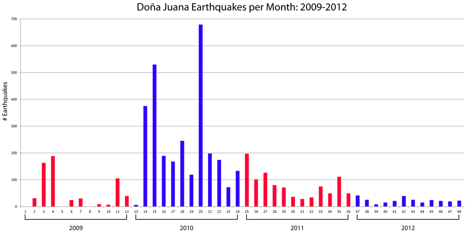 |
Figure 5. Monthly earthquakes detected with the Doña Juana seismic network during 2009-2012. The number of earthquakes represents a sum of volcano-tectonic, tremor, long period, hybrid, and 'VOL' (see text) events per month. Bar color alternates from red to blue to distinguish years. Courtesy of INGEOMINAS. |
Seismicity peaked in August 2010 owing to three VT swarms. That month the various earthquakes totaled more than 675 events. These were low-magnitude earthquakes (M 0-2.7) with relatively shallow depths (7-10 km below the summit).
The calculated locations of earthquakes were available for events during 2010-2012 (table 1). During this time period, epicenters were frequently dispersed between Doña Juana and Ánimas except for the mid-2010 activity and during January-February 2011. This record of information highlights the significance of August 2010 when VT earthquakes were clustered ~7 km NE of Doña Juana, slightly closer to the older volcanic edifice Ánimas (figure 6).
Table 1. During June 2010-December 2012, earthquake detection was sufficient for calculating magnitudes and locations. During several months (January-May 2010, June and October 2011, and September and November 2012) no locations were determined. "Notes" refer to epicenter characteristics such as clustering locations; "dispersed" events are those that occurred at various depths and distances from the volcanic centers. Courtesy of INGEOMINAS.
| Month | Total Located | Magnitude | Depth (km below summit) | Notes |
| Jun 2010 | 68 | 0.1-2.6 | 5-10 | ~5 km SW of Ánimas |
| Jul 2010 | 14 | 0.2-1.5 | 6-10 | ~5 km SW of Ánimas |
| Aug 2010 | 130 | 0-2.7 | 7-10 | ~5 km SW of Ánimas |
| Sep 2010 | 34 | 0.2-2.1 | 1-11 | ~5 km SW of Ánimas |
| Oct 2010 | 10 | 0.6-2.7 | ~7 | dispersed |
| Nov 2010 | 5 | 1.1-2.3 | 3-6 | dispersed |
| Dec 2010 | 7 | 0.2-1.8 | 4-10 | dispersed |
| Jan 2011 | 59 | 0.1-3.1 | 3-14; 6-8 | ~8 km SW of Ánimas; many earthquakes clustered at 6-8 km depth |
| Feb 2011 | 1 | 1.2 | 7 | 2 km SW of Ánimas |
| Mar 2011 | 7 | 0.5-2.1 | 15-50 | between Doña Juana and Ánimas |
| Apr 2011 | 2 | -- | 5.7-6.5 | between Doña Juana and Ánimas |
| May 2011 | 2 | 0.4, 1.7 | 8, 11 | dispersed |
| Jun 2011 | -- | -- | -- | -- |
| Jul 2011 | 9 | 0.3-1.1 | 6-12 | some clustering near Ánimas |
| Aug 2011 | 7 | -- | 4-15 | between Doña Juana and Ánimas |
| Sep 2011 | 1 | 0.7 | 4 | between Doña Juana and Ánimas |
| Oct 2011 | -- | -- | -- | -- |
| Nov 2011 | 9 | 0.3-1.5 | 3-8 | between Doña Juana and Ánimas |
| Dec 2011 | 2 | 0.9, 1.7 | 4-6 | between Doña Juana and Ánimas |
| Jan 2012 | 16 | 0.3-1.5 | 1-19 | between Doña Juana and Ánimas |
| Feb 2012 | 5 | 0.9-1.7 | 2-8 | between Doña Juana and Ánimas |
| Mar 2012 | 2 | 0.8, 1.3 | 7 | between Doña Juana and Ánimas |
| Apr 2012 | 5 | 0.4-1.3 | 0-18 | dispersed |
| May 2012 | 7 | 0.5-1.4 | 3-9.5 | dispersed |
| Jun 2012 | 20 | 0-2.3 | 1-14 | dispersed |
| Jul 2012 | 13 | 0.7-1.9 | 1-14 | dispersed |
| Aug 2012 | 6 | 0.2-1.9 | 0-14.5 | SW of Doña Juana |
| Sep 2012 | -- | -- | -- | -- |
| Oct 2012 | 4 | 0.7-1.3 | 0-20 | SW of Doña Juana |
| Nov 2012 | -- | -- | -- | -- |
| Dec 2012 | 2 | 1.1, 0.7 | 2, 20 | ~10 km S of Doña Juana |
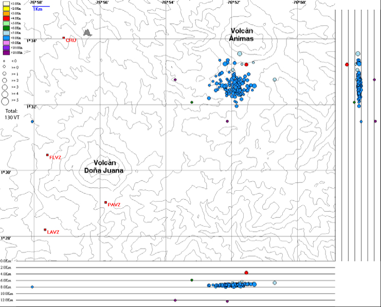 |
Figure 6. Volcano-tectonic seismicity during August 2010 was characterized by a swarm located between Doña Juana and Ánimas volcano; ~8 km NE of Doña Juana. Courtesy of INGEOMINAS. |
Colombia's 52nd Natural National Park. In 2007, the Doña Juana-Cascabel Volcanic Complex Natural National Park was created both by the Ministry of Environmental, Housing and Territorial Development and the Colombian Natural National Parks (figure 7). This included Doña Juana, Ánimas, and Petacas volcano (located ~19 km NE of Doña Juana) within the 65,858 hectares of preserved land. Within this densely forested region, a series of streams and waterfalls was locally known as El Cascabel. The park was developed to protect diverse flora and fauna, including numerous endangered species such as the Andean condor, the Moor tapir, the spectacled bear, and puma; approximately 11% of the park includes alpine terrain.
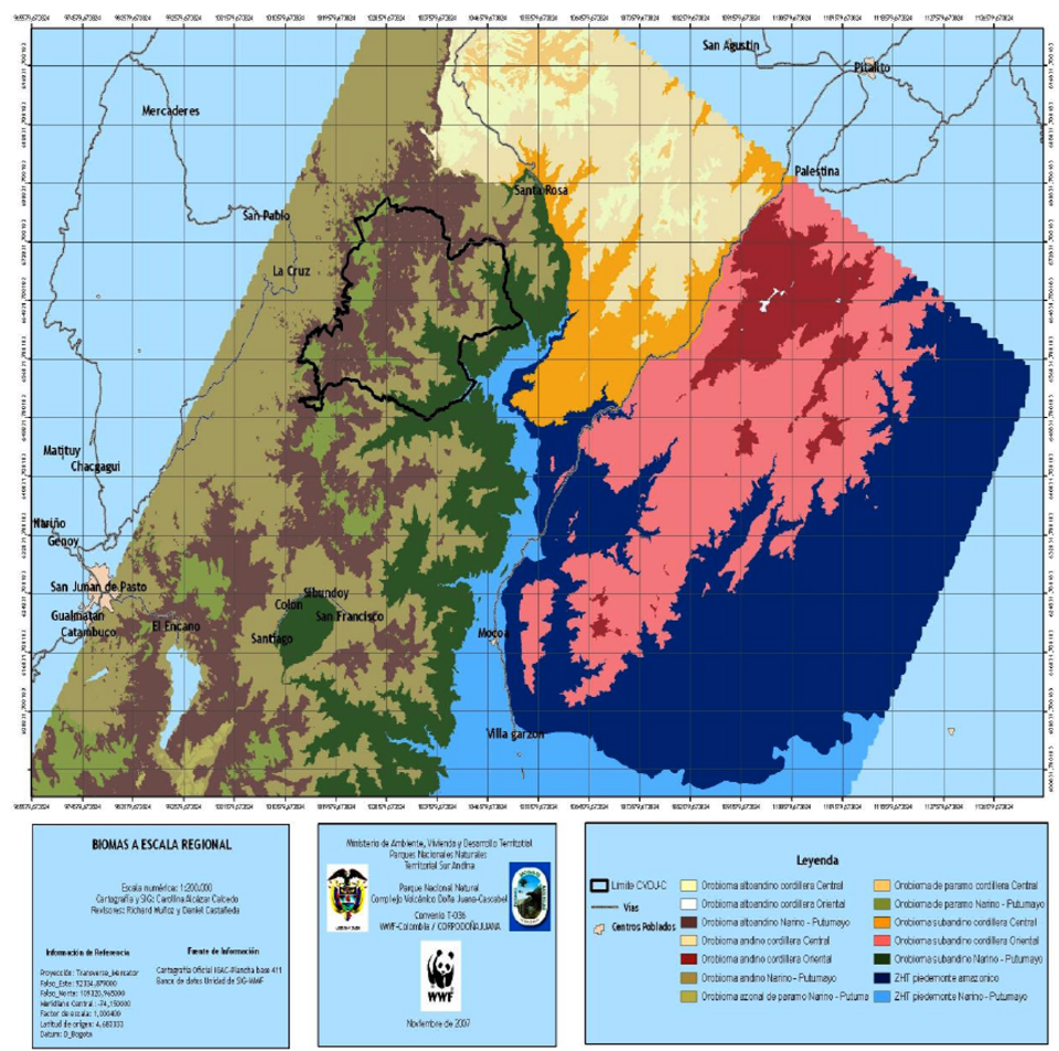 |
Figure 7. This map of biomes includes the Doña Juana-Cascabel Volcanic Complex Natural National Park and surrounding region. Doña Juana is located in the SW portion of the park. Shaded areas indicate low-elevation Amazon through high-elevation Andean environments. The park boundary is indicated by a heavy black line; populated areas are shaded light pink, road systems are represented by gray lines, and major towns are labeled. This map appears in the 2008-2013 Management Plan of PNN CVDJ-C (2008). |
References. Department of the Environment, Housing and Territorial Development Special Administration Unit of the system of Natural National Parks (UAESPNN), 2008, Doña Juana-Cascabel Volcanic Complex Natural National Park (PNN CVDJ-C) Management Plan 2008-2013, Popayán, Colombia, July 2008.
Siebert L., Simkin T., and Kimberly P., 2010, Volcanoes of the World, 3rd edition, University of California Press, Berkeley, 558 p.
Geological Summary. The forested Doña Juana stratovolcano contains two calderas, breached to the NE and SW. The summit of the andesitic-dacitic volcano is comprised of a series of post-caldera lava domes. The older caldera, open to the NE, formed during the mid-Holocene, accompanied by voluminous pyroclastic flows. The younger caldera contains the active central cone. The only historical activity took place during a long-term eruption from 1897-1906, when growth of a summit lava dome was accompanied by major pyroclastic flows.
Information Contacts: Instituto Colombiano de Geologia y Mineria (INGEOMINAS), Observatorio Vulcanológico y Sismológico de Pasto, Pasto, Colombia (URL: https://www2.sgc.gov.co/volcanes/index.html); WWF Colombia (URL: http://www.wwf.org.co/?109882/Nuevo-Parque-Nacional-Natural-en-el-piedemonte-Andino-Amazonico-colombiano); Doña Juana-Cascabel Volcanic Complex National Natural Park (URL: http://www.parquesnacionales.gov.co/).