Report on Saunders (United Kingdom) — February 2013
Bulletin of the Global Volcanism Network, vol. 38, no. 2 (February 2013)
Managing Editor: Richard Wunderman.
Saunders (United Kingdom) Eruption from ‘new’ vent
Please cite this report as:
Global Volcanism Program, 2013. Report on Saunders (United Kingdom) (Wunderman, R., ed.). Bulletin of the Global Volcanism Network, 38:2. Smithsonian Institution. https://doi.org/10.5479/si.GVP.BGVN201302-390090
Saunders
United Kingdom
57.8°S, 26.483°W; summit elev. 843 m
All times are local (unless otherwise noted)
Matthew Patrick (USGS-HVO) notified Bulletin editors that in late 2012 images from thermal sensing satellites showed a 'new' active vent on Mount Michael on Saunders Island in the South Sandwich Islands (see location map, figure 1 in BGVN 28:02). This prompted scrutiny of the same vent in earlier images. Patrick noted that, although the vent was first identified in the 2012 images, it also appeared as activity in satellite images starting in 2006. The South Sandwich Islands are generally devoid of vegetation and habitants, and are largely ice-bound. Thus, satellite thermal alerts are strong evidence of volcanism.
Patrick shared with us the following information from a paper by Patrick and Smellie (2013) about the vent, labeled as Old Crater (SE and outside of main crater, see figure 2 in BGVN 28:02). ASTER [Advance Spaceborne Thermal Emission and Reflection Radiometer] imagery provided "new information on the small subordinate crater, marked as 'Old Crater' by Holdgate and Baker (1979), presumably because it was inactive at the time of their observations." An ASTER image on 28 October 2006 showed an apparent SWIR [short-wave infrared] anomaly at Old Crater. The crater itself appeared to be snow-free and was approximately 150 m in diameter. An ASTER image from 5 January 2008, showed a steam plume coming from this vent, which appeared to be about 190 m wide, as well as a TIR [thermal infrared] anomaly. A very high resolution image from November 2009 available on Google Earth showed a small steam plume emanating from the crater, which is about 190 m wide (figure 8). An ASTER image from 17 November 2010, showed apparently recent eruptive activity in Old Crater, evidenced by tephra fallout emanating from the crater and a small TIR anomaly (at the time there was also a TIR anomaly in the main crater). According to Patrick and Smellie, the plume, tephra fall, SWIR anomalies, and crater enlargement (from 150 to 190 m) indicated that this vent had reactivated by late 2006.
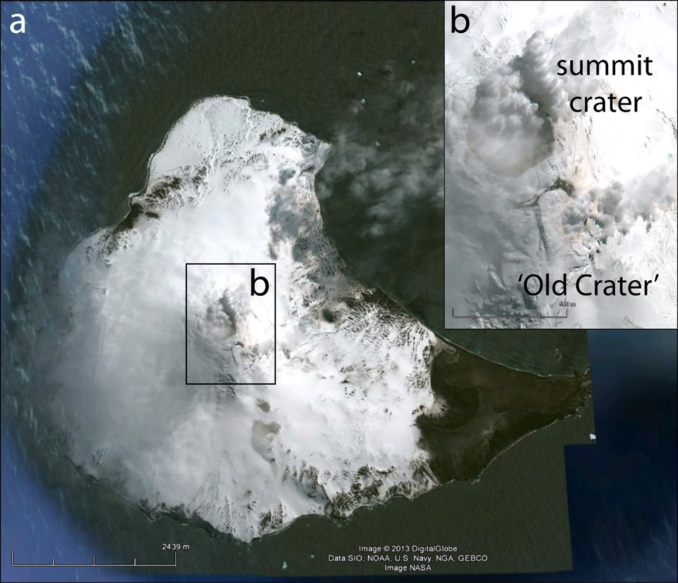 |
Figure 8. Annotated Google Earth imagery of Michael volcano (Saunders Island) acquired on 19 November 2009. (a) Saunders Island is mostly glacier covered, and steam plumes rose from the summit area. The scale bar indicates a distance of ~2.4 km. (b) A close up of the summit area that clearly shows steam plumes emanating from both the summit crater as well as the snow-filled 'Old Crater' (as termed by Holdgate and Baker, 1979). The scale bar indicates a distance of ~0.5 km. Courtesy of Google Earth. |
MODVOLC satellite thermal alerts measured from the volcano since our last Bulletin report (BGVN 33:04, activity through May 2008) and to 4 April 2013 are shown in Table 3. A solitary alert appeared 25 October 2008, followed by a four year period of apparent inactivity. Then, another solitary alert was measured in late June 2012, followed by alerts for two days in October 2012 and two days in November 2012. Patrick noted that occasional and sporadic alerts are very typical for Michael.
Table 3. Satellite thermal alerts measured by MODVOLC over Michael from 2008-February 2013. Pixel sizes generally range from 1-1.5 km2. Note that previous satellite thermal alerts for Michael were listed in BGVN 31:10 (October 2005-November 2006) and 33:04 (August 2000-May 2008). Courtesy of MODVOLC.
| Date | Time (UTC) | Number of pixels | Satellite |
| 25 Oct 2008 | 0100 | 1 | Terra |
| 30 Jun 2012 | 0100 | 1 | Terra |
| 02 Oct 2012 | 0110 | 1 | Terra |
| 28 Oct 2012 | 0200 | 2 | Aqua |
| 28 Oct 2012 | 1125 | 2 | Terra |
| 14 Nov 2012 | 0055 | 3 | Terra |
| 22 Nov 2012 | 1120 | 2 | Terra |
References. Patrick, M.R., and Smellie, J.L., 2013, A spaceborne inventory of volcanic activity in Antarctica and southern oceans, 2000-2010, Antarctic Science, v. 25, no. 4, p. 475-500.
Holdgate, M.W., and Baker, P.E., 1979. The South Sandwich Islands: I. General description, British Antarctic Survey Scientific Reports, No. 91, pp. 1-76.
Geological Summary. Saunders Island consists of a large central volcanic edifice intersected by two seamount chains, as shown by bathymetric mapping (Leat et al., 2013). The young Mount Michael stratovolcano dominates the glacier-covered island, while two submarine plateaus, Harpers Bank and Saunders Bank, extend north. The symmetrical Michael has a 500-m-wide summit crater and a remnant of a somma rim to the SE. Tephra layers visible in ice cliffs surrounding the island are evidence of recent eruptions. Ash clouds were reported from the summit crater in 1819, and an effusive eruption was inferred to have occurred from a N-flank fissure around the end of the 19th century and beginning of the 20th century. A low ice-free lava platform, Blackstone Plain, is located on the north coast, surrounding a group of former sea stacks. A cluster of cones on the SE flank, the Ashen Hills, appear to have been modified since 1820 (LeMasurier and Thomson, 1990). Analysis of satellite imagery available since 1989 (Gray et al., 2019; MODVOLC) suggests frequent eruptive activity (when weather conditions allow), volcanic clouds, steam plumes, and thermal anomalies indicative of a persistent, or at least frequently active, lava lake in the summit crater. Due to this observational bias, there has been a presumption when defining eruptive periods that activity has been ongoing unless there is no evidence for at least 10 months.
Information Contacts: Matthew Patrick, Hawaiian Volcano Observatory (HVO), U.S. Geological Survey, PO Box 51, Hawai'i National Park, HI 96718, USA (URL: https://volcanoes.usgs.gov/observatories/hvo/); MODVOLC, Hawai'i Institute of Geophysics and Planetology (HIGP) Thermal Alerts System, School of Ocean and Earth Science and Technology (SOEST), Univ. of Hawai'i, 2525 Correa Road, Honolulu, HI 96822, USA (URL: http://modis.higp.hawaii.edu/).