Report on Niuatahi (Tonga) — March 2013

Bulletin of the Global Volcanism Network, vol. 38, no. 3 (March 2013)
Managing Editor: Richard Wunderman.
Niuatahi (Tonga) New research data collected from submarine volcano
Please cite this report as:
Global Volcanism Program, 2013. Report on Niuatahi (Tonga) (Wunderman, R., ed.). Bulletin of the Global Volcanism Network, 38:3. Smithsonian Institution. https://doi.org/10.5479/si.GVP.BGVN201303-243140
Niuatahi
Tonga
15.3675°S, 174.0028°W; summit elev. -1270 m
All times are local (unless otherwise noted)
Richard Arculus (2012), David Butterfield (2012), and Keener and Vailea (2012) discussed the Submarine Ring of Fire Expedition 2012 of the Research Vessel R/V Revelle during 14-15 September 2012. They conducted bathymetric profiles and submersible observations of a caldera originally called 'Volcano O' in the Tonga arc (figure 1). During this cruise, the name 'Niua Tahi' was given to this extraordinarily symmetrical, circular caldera, 15 km in diameter at 1.2 to 2 km depth, by a Senior Geological Assistant aboard from the Tonga Ministry of Lands, Environment, Climate Change and Natural Resources. According to Keener and Vailea (2012), "Volcano O, was named 'Niua Tahi' during our expedition by the Ministry, which in Tongan means 'sea', with the small cone within it being named 'Motu Tahi', or 'island in the sea'."
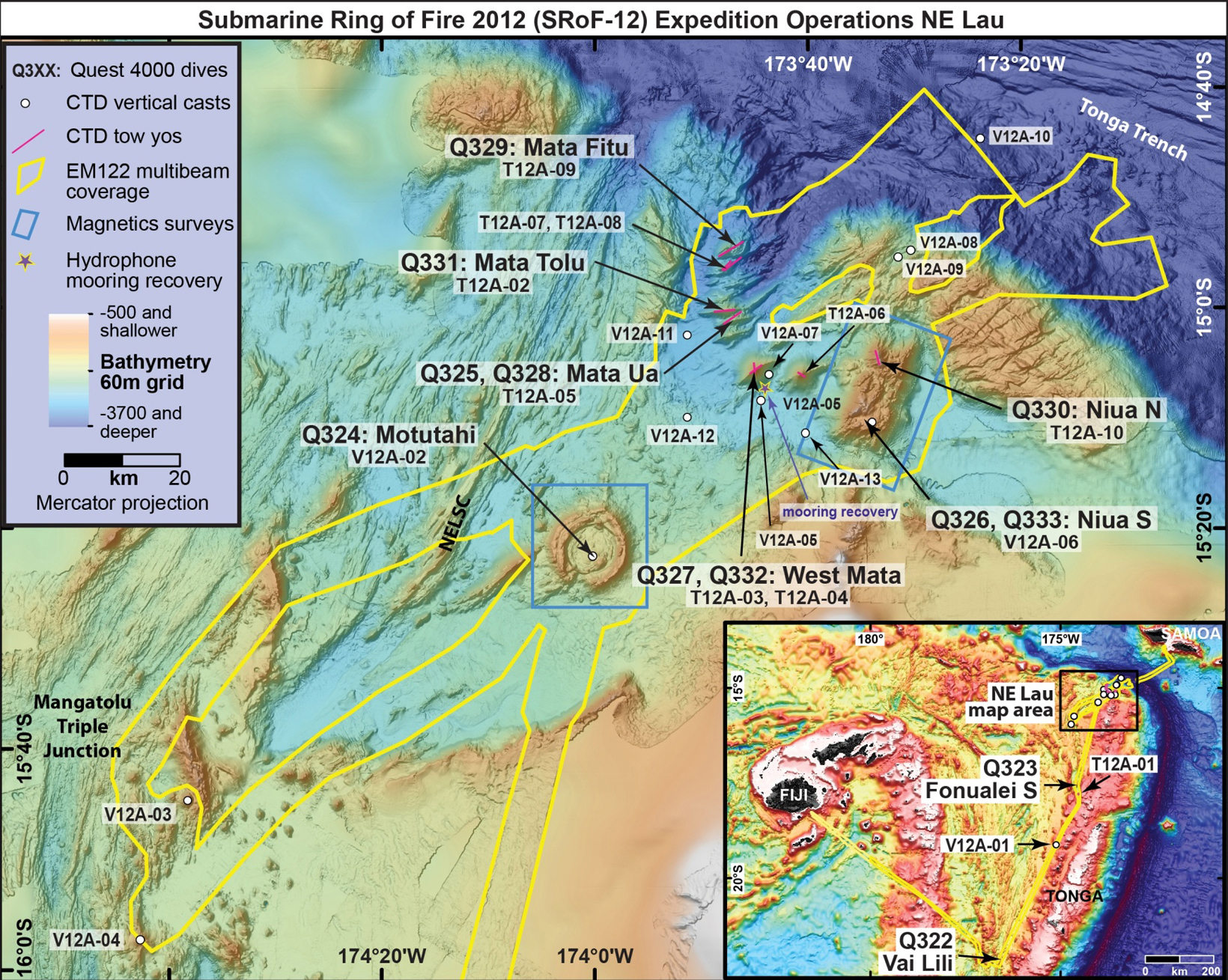 |
Figure 1. Map of operations of Submarine Ring of Fire 2012 in the NE Lau Basin. Map features the NE Lau Basin area, where the majority of cruise took place. The inset in the upper left shows a key to the various tasks for the entire cruise, and the insert map in the lower right shows the general area with respect to the locations of Samoa and Fiji. Niua Tahi volcano is identified as 'Q324: MotutahiI' (the new name for the volcano's small cone) on the map. Image from Resing and Embley (2012); courtesy of Submarine Ring of Fire 2012: NE Lau Basin, NOAA-OER. |
Niua Tahi is a giant, near-circular caldera ~15 km in diameter, with a floor at a depth of about 2 km (Arculus, 2012). A young cone (Motu Tahi) in the SE sector rises 730 m above the floor to a summit at a depth of 1,270 m depth. The volcano is in the rear arc of the Tonga system, located ~40 km W of the chain of subaerial-submarine volcanic edifices that define the volcanic front of the Tonga Arc, and 25 km E of the spreading ridge of the Northeast Lau Spreading Center. The composition of the cone and surrounding floor is predominantly dacite. Towing with sea-floor cameras over the cone and various parts of the caldera resulted in the discovery of at least three sources of hydrothermal particle venting on the cone's summit and adjacent to the inner caldera walls.
During the cruise, the remotely operated vehicle (ROV) Quest 4000 (operated by MARUM, the Center for Marine Environmental Sciences at the University of Breman, Germany) traversed from W to E over the volcano summit and around the margins of the central cone. The cone contained a shallow pit surrounding what appears to be a volcanic vent, probably the site of the most recent volcanism (figures 2a and 2b). The ROV showed that the summit of the cone was mantled with a ubiquitous sulfur-rich layer that coated rugged blocks of pillow lava, lava tubes, and ash-and-blocks deposits.
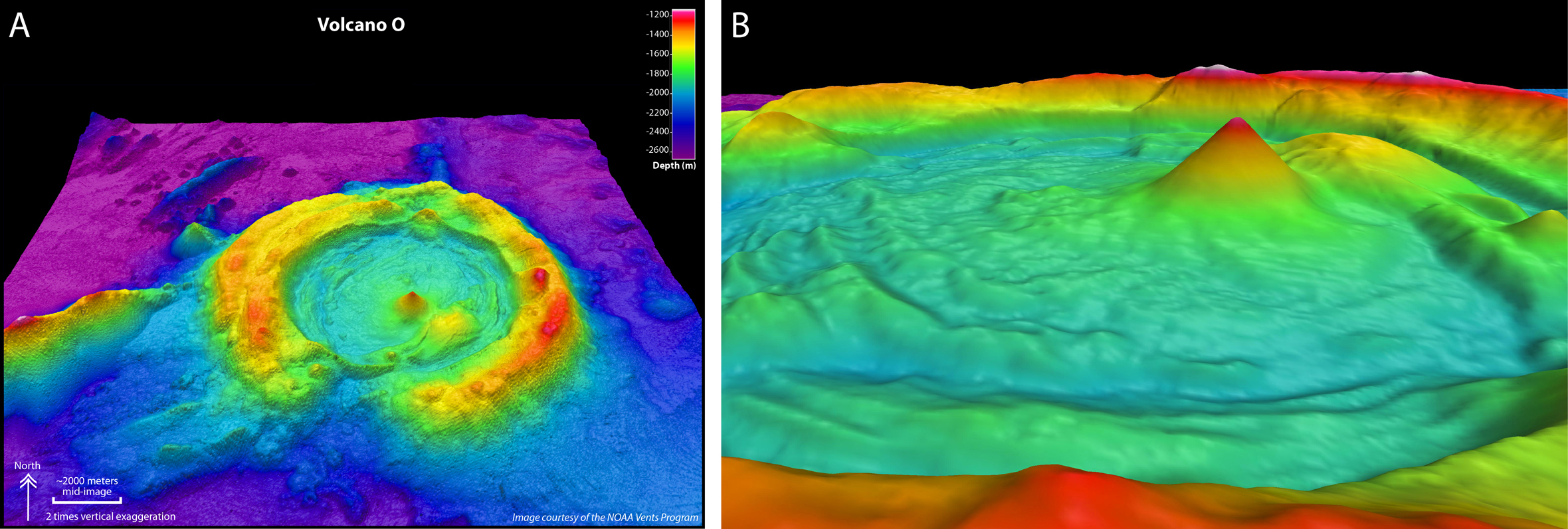 |
Figure 2. (a) Multibeam bathymetry image of Niua Tahi, looking N, with two-fold vertical exaggeration. Color scale for depths is shown in upper right. (b) Multibeam bathymetry image of the cone in the caldera of Niua Tahi. The image is viewed looking E, without vertical exaggeration. The color scale for depths from Figure 2a is the same for this figure. Both images courtesy of Susan Merle, Oregon State University, Submarine Ring of Fire 2012 Exploration, NOAA Vents Program; on web site of Arculus (2012). |
The ROV images revealed the presence of a NE-trending elongated pit crater at the cone's summit emitting a plume bearing a sulfurous particulate-rich plume. Several previous observations of the water column detected similar plumes. Hot, clear water (~105°C) welled up in numerous places through the loosely agglomerated pyroclastic materials forming both the rim of the crater and flanks of the cone. The attempt to descend the ROV into the pit for a closer look was thwarted by the dense clouds of sulfurous 'smoke.' The most recent volcanic activity was likely dominated by lava and volcaniclastic debris.
References. Arculus, R., 2012 (14 September), Crossing the cone at "Volcano O," Ocean Explorer (URL: http://oceanexplorer.noaa.gov/explorations/12fire/logs/sept14/sept14.html).
Butterfield, D., 2012 (15 September), Chemistry and ecology at volcano O, Ocean Explorer (URL: http://oceanexplorer.noaa.gov/explorations/12fire/logs/sept15/sept15.html).
Keener, P., and Vailea, A., 2012 (24 September), In keeping with tradition, Ocean Explorer (URL: http://oceanexplorer.noaa.gov/explorations/12fire/logs/sept24/sept24.html).
Resing, J., and Embley, B., 2012, Mission summary, NOAA Ocean Explorer web site (URL: http://oceanexplorer.noaa.gov/explorations/12fire/logs/summary/summary.html).
Geological Summary. Niuatahi is a nearly circular caldera ~15 km in diameter, with a floor at a depth of about 2 km (Arculus, 2012). A young cone (Motu Tahi) in the SE sector rises 730 m above the floor to a summit depth of about 1,270 m. The volcano is in the Northeast Lau Basin, ~40 km W of the edifices along the Tofua Volcanic Arc, and 25 km E of the central ridge of the Northeast Lau Spreading Center. The composition of the cone and surrounding floor is predominantly dacite. Towing with seafloor cameras over the cone and various parts of the caldera in 2012 resulted in the discovery of at least three sources of hydrothermal particle venting on the cone's summit and adjacent to the inner caldera walls. The Tonga Ministry of Lands, Environment, Climate Change and Natural Resources named the volcano Niuatahi, which means 'sea' in Tongan, with the small cone of Motutahi meaning 'island in the sea'; it had previously been given an unofficial research cruise designation of "Volcano O."
Information Contacts: Richard Arculus, Research School of Earth Sciences, The Australian National University, Canberra, Australia; Susan Merle, Oregon State University, Eugene, OR, Submarine Ring of Fire 2012 Exploration, NOAA Vents Program; Center for Marine Environmental Sciences (MARUM), University of Bremen, Bremen, Germany (URL: https://www.marum.de/); NOAA Vents Program (URL: https://www.pmel.noaa.gov/eoi/laubasin.html).