Report on Kanaga (United States) — March 2013
Bulletin of the Global Volcanism Network, vol. 38, no. 3 (March 2013)
Managing Editor: Richard Wunderman.
Kanaga (United States) 18 February 2012 eruption; new fissure
Please cite this report as:
Global Volcanism Program, 2013. Report on Kanaga (United States) (Wunderman, R., ed.). Bulletin of the Global Volcanism Network, 38:3. Smithsonian Institution. https://doi.org/10.5479/si.GVP.BGVN201303-311110
Kanaga
United States
51.923°N, 177.168°W; summit elev. 1307 m
All times are local (unless otherwise noted)
In our last report on Kanaga, issued in 1995 (BGVN 20:08), we discussed an eruption during January through mid-October 1994. In addition to a brief explosion in February 2012, more information from the Alaska Volcano Observatory (AVO) has come to our attention, some discussing events more than a decade ago. This information suggested either renewed low level eruptions or vigorous steaming from lava cooling in the summit crater.
What follows is condensed from reports, primarily by researchers at AVO, describing the time span from 1996 to 2012. Data for 2012 is in a separate subsection. The last section looks at Kanaga seismicity in terms of located earthquakes and MC, Magnitude of Completeness, a means of looking at seismic data quality, homogeneity, and consistency, and the smallest events reliably recorded in the cataloged data (Wiemer and Wyss, 2000).
Figures 1 and 2 comprise three maps showing, respectively, the location of Kanaga Island in the Aleutian Islands, a physical map of Kanaga Island showing the location of Kanaga volcano, and a geological map of the volcano.
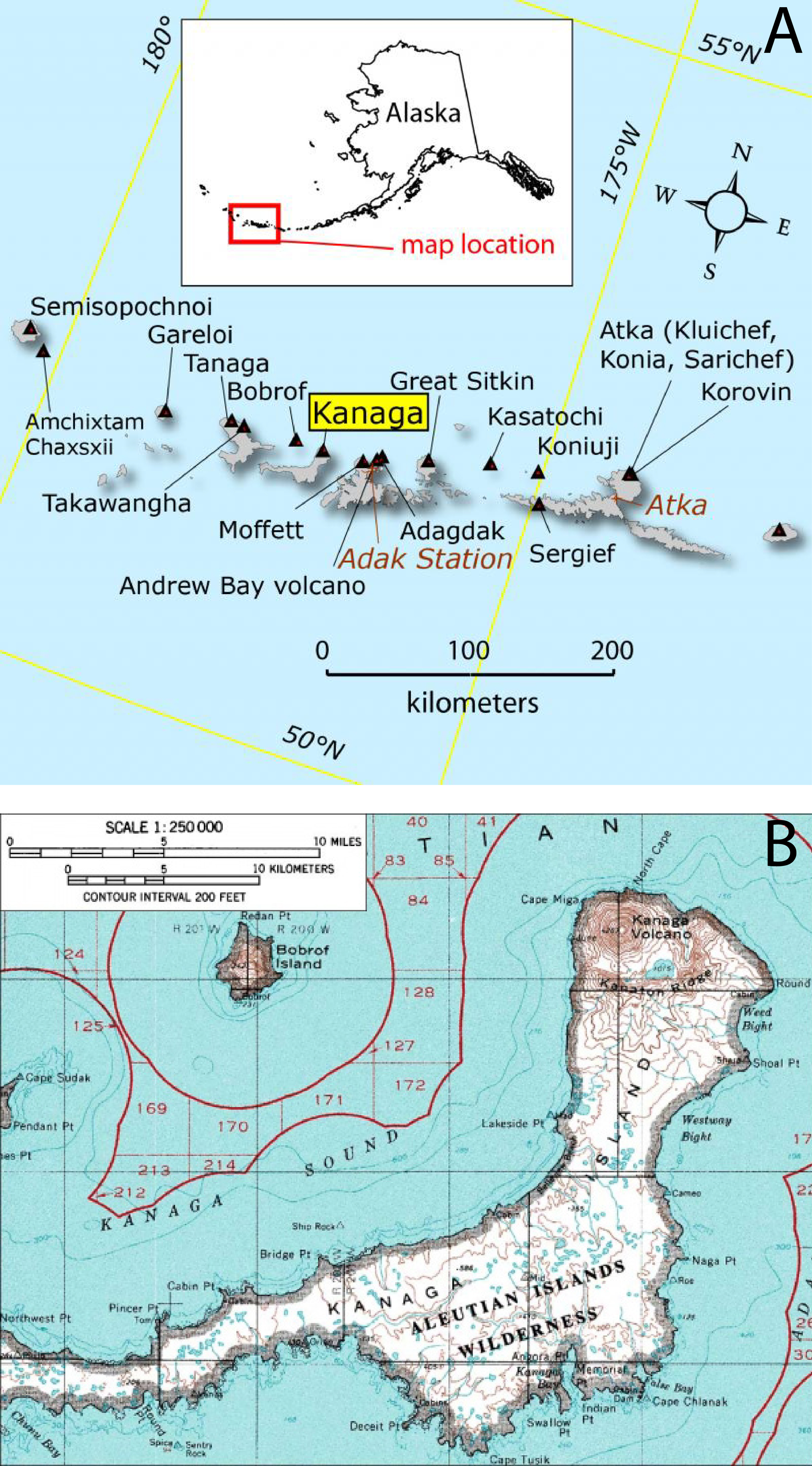 |
Figure 1. (a) Map of the western Aleutian Islands, Alaska, showing the location of Kanaga Island. Courtesy of AVO. (b) Topographic map of Kanaga Island showing Kanaga volcano on the northernmost portion of the island. Courtesy of U.S. Geological Survey (USGS) and Amar Andalkar. |
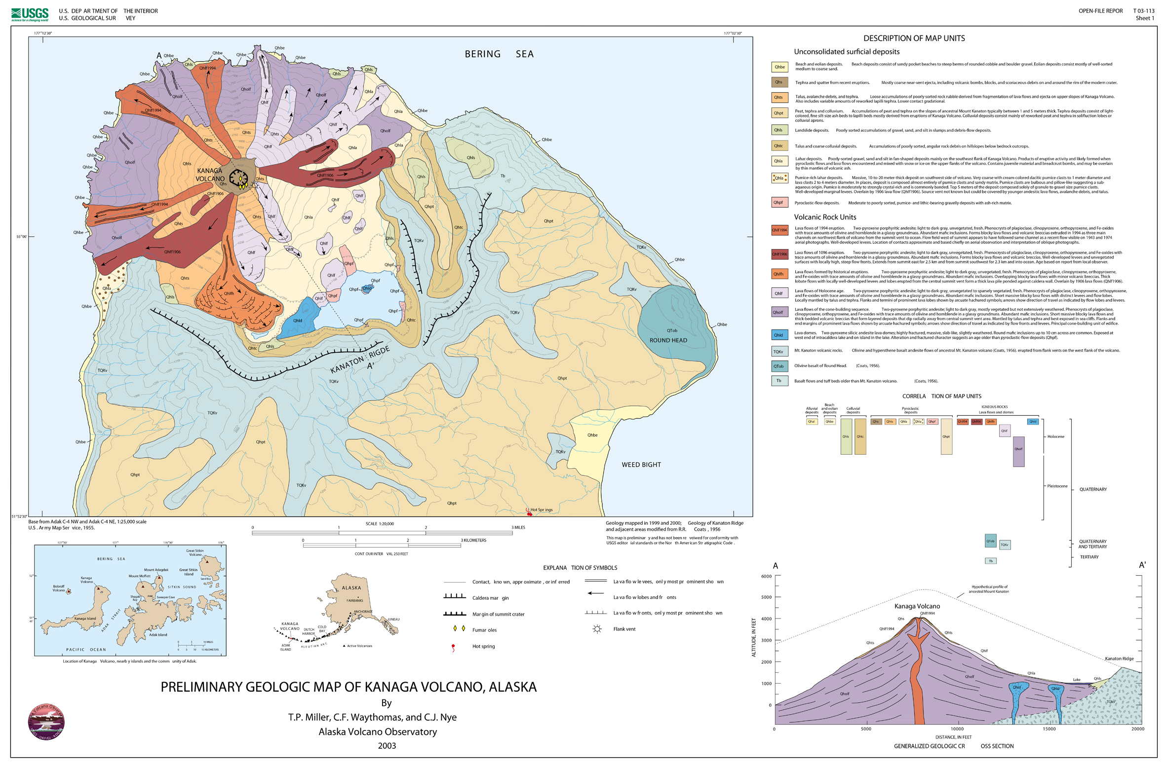 |
Figure 2. Preliminary geologic map showing Kanaga volcano. Notice that concentric to Kanaga to the SE is the arcuate Kanaton Ridge, inferred to be the remnant of Mount Kanaton, an ancestral volcano destroyed by structural collapse; see generalized geologic cross section in the lower right-hand side of the figure. Courtesy Miller and others (2003, Sheet 1). |
According to McGimsey and Neal (1997), a commercial airline crew noted a small, bluish brown cloud possibly containing some ash on 11 June 1996, "rising a few hundred feet above the summit of the volcano." Strong winds carried the cloud down the SE flank of the volcano, depositing ash that discolored the snow. The flight crew noted a sulfur odor upon descent into nearby Adak Island. A ground observer on Adak noted dark splotches on the E flank of Kanaga, but a ballistic origin for the pattern (i.e., volcanic bombs) was never confirmed. It should be noted that these observations occurred several days after an M 6 earthquake in the area, and extensive rockfalls and increased steaming had been observed at Gareloi and Kasatochi volcanoes E and W of Kanaga.
Kevin Bell, the captain of the RV Tiglax, watched Kanaga from a point off its N flank on 3 September 1996. He observed that the extent of lava flows was similar to that inferred from 1995 photographs. Small wisps of steam persisted along the upper reaches of the lava flow on the NW flank. Bell also saw material rolling down the steep flank of the volcano during the Summer and Fall of 1996.
Waythomas and others (2002) noted that ash clouds from Kanaga could interfere with the commercial airliners flying between East Asia and Alaska. Figure 3 shows a satellite image of Kanaga volcano taken 13 August 2002.
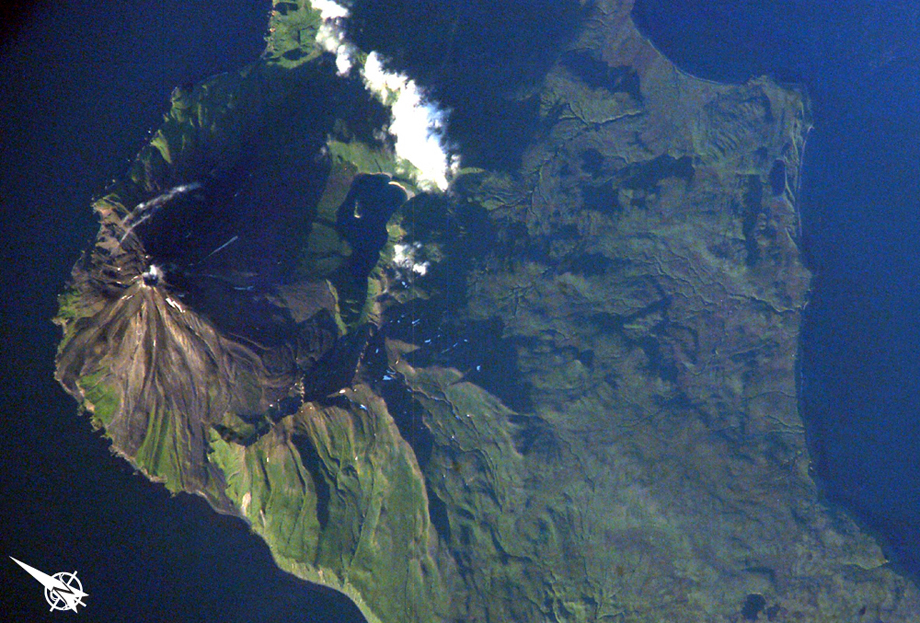 |
Figure 3. An astronaut's photograph acquired late in the day of 13 August 2002 of Kanaga volcano; N is approximately to the left. The volcano is known for its active fumaroles and hot springs (located, in this image, by fine steam plumes on the NE flank of the volcano). A small lake to the SE of the cone is situated on the floor of a larger, more ancient volcanic caldera. Astronaut photograph ISS005 E 10097, from NASA Earth Observatory; courtesy of the Earth Sciences and Image Analysis Laboratory at Johnson Space Center. |
Coombs and others (2007) described subaerial evidence for large-scale prehistoric collapse at Kanaga volcanic center and conducted submarine side-scan sonar profiling N of the volcano. These data reveal a hummocky seafloor topography suggestive of landslide debris.
2012 Activity. AVO detected volcanic tremor at Kanaga from 1523 to 1527 UTC on 18 February 2012. This was followed by numerous small earthquakes at Kanaga continuing for about an hour.
A possible weak ash cloud ~8 km in length, ~39 km NE of the volcano, was detected by the Advanced Very High Resolution Radiometer (AVHRR) aboard a polar-orbiting satellite, at 1535 UTC. The plume was observed as far as ~39 km NE of the volcano.
Because of the new unrest and possible explosive activity with the likely ash cloud, AVO raised the Alert Level to Advisory and the Aviation Color Code to Yellow. Somewhat elevated seismicity continued at Kanaga on 19 February 2012, but was not detectable on 20 February. Low amplitude tremor was detected on 25 February. On 2 March, citing continued background level seismicity, AVO returned Kanaga to Normal and the Aviation Color Code to Green.
Photographs taken by a local observer on 19 February showed a small steam plume rising from Kanaga's crater (figure 4), who thought that the two dark stripes extending down the flank possibly represent fresh ash and/or flowage deposits.
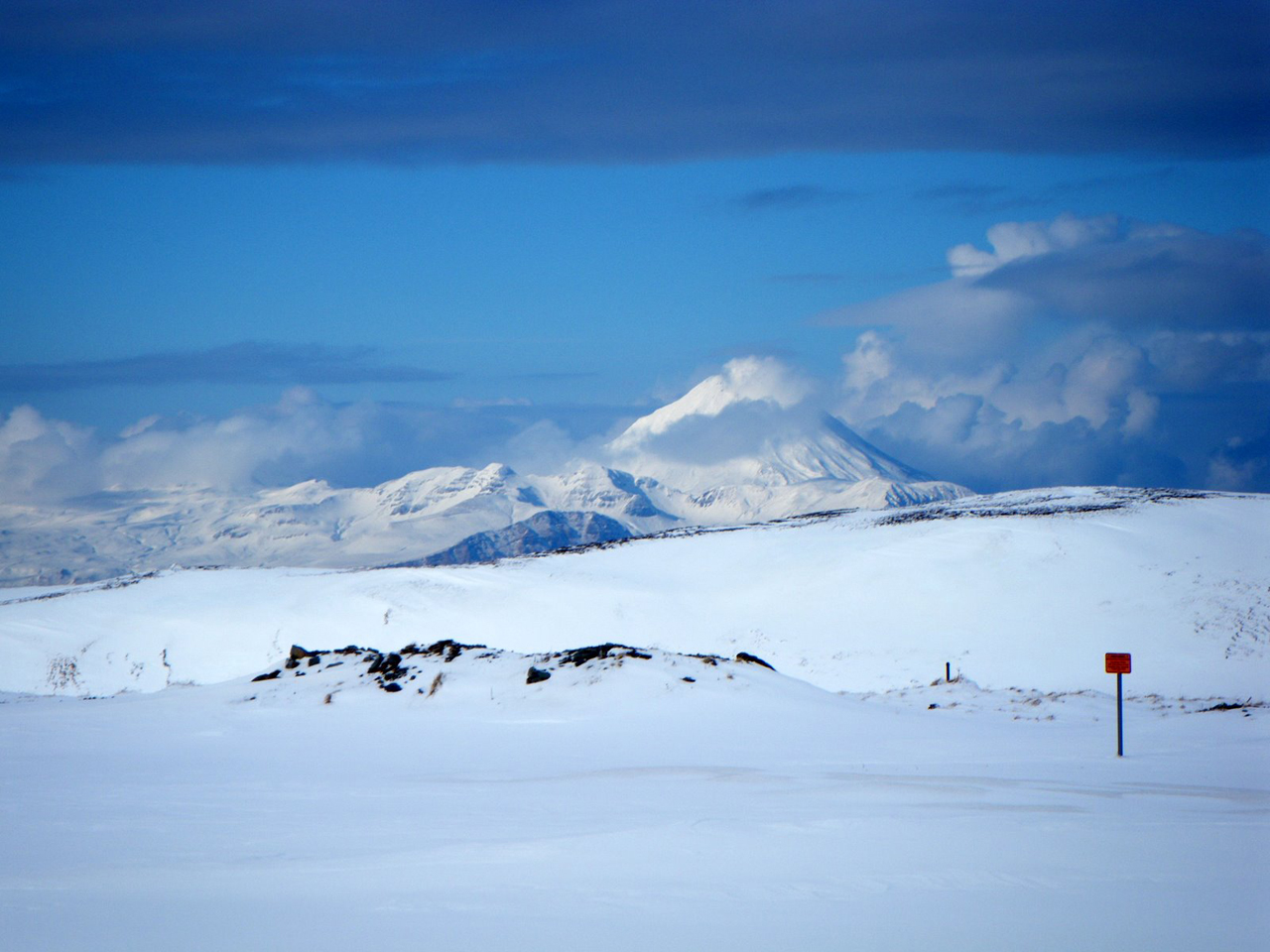 |
Figure 4. Kanaga volcano emitting a steam plume at 1226 on 19 February 2012. Photo taken from the White Alice site, ~3 km W of Adak, Alaska; courtesy of Marjorie Tillion, from AVO web site. |
Figures 5-7 show images and photographs of Kanaga taken in the weeks and months following the brief 18 February eruption. The fissure, which vented steam, developed sometime after October 2011.
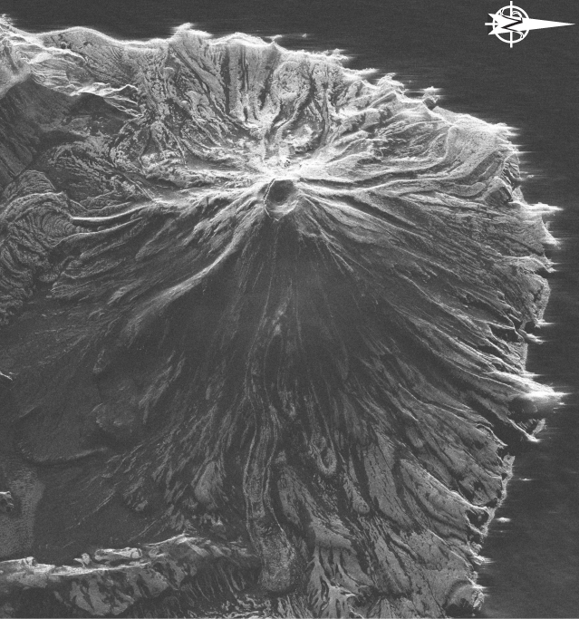 |
Figure 5. Radar image of Kanaga collected on 5 March 2012. N is to the right. AVO workers described an E-trending fissure crossing the S crater rim and continuing part way down the W flank. Total length of the fissure was estimated at ~600 m. It developed sometime after October 2011. As mentioned in text, a short duration explosive eruption occurred on 18 February 2012. It was unclear whether that 18 February activity and the development of the fissure were related. TerraSar-X image copyright ©2012 Infoterra GmbH courtesy of Zhong Lu and David Schneider AVO/USGS. |
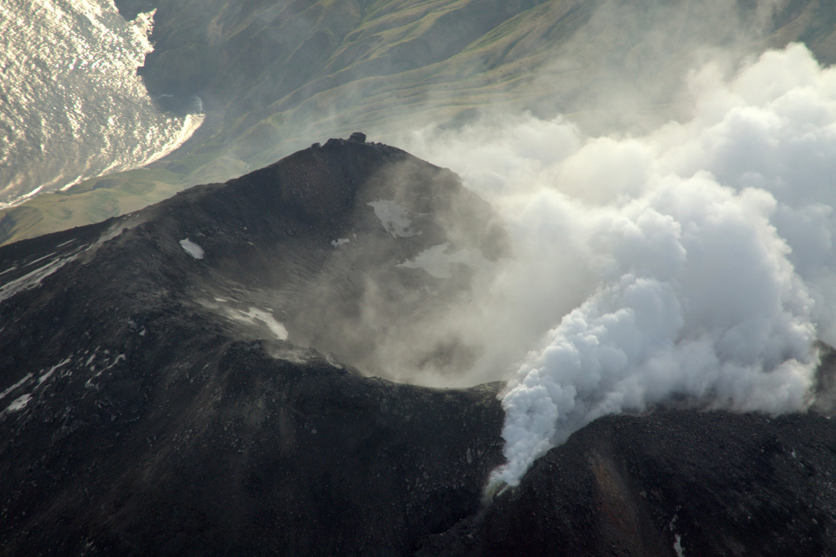 |
Figure 6. Aerial photograph taken at 1200 on 30 June 2012 of Kanaga's summit with a fissure emitting steam. Photograph by Cyrus Read; image courtesy of AVO/USGS. |
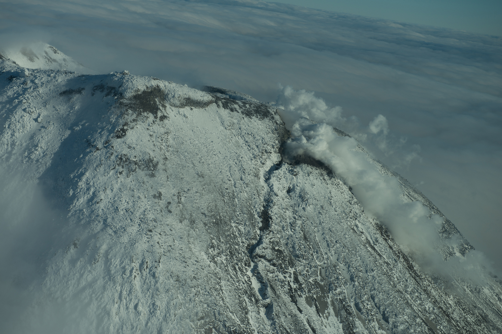 |
Figure 7. Aerial photograph of Kanaga looking E, taken November 2012. The steam discharged from the E-trending fissure on the S side of the dome. Photograph courtesy of Roger Clifford. |
Located earthquakes enable computation of MC. Table 1 shows the annual number of located earthquakes recorded by the U.S. Geological Survey (USGS) within 20 km of the Kanaga volcanic center for the years of 2004-2011. References for this table came from USGS catalogs of earthquake hypocenters at Alaskan volcanoes are cited in a separate list below. The catalog for 2012 is not yet available. The first seismic monitoring station at Kanaga was installed in September 1999.
Table 1. Number of earthquakes for various years located for the Kanaga volcano seismograph subnetwork within 20 km of the volcanic center. The column of "Other" earthquakes refers to those outside the defined categories of VT and LP (including hybrid, regional-tectonic, teleseismic, shore-ice, calibrations, other non-seismic, and cause unknown). Compiled from the U.S. Geological Survey's annual Catalog of Earthquake Hypocenters at Alaskan Volcanoes.
| Year | Earthquakes Located | Volcano-tectonic (VT) | Low-frequency (LF) | Other |
| 2004 | 32 | 30 | 2 | 0 |
| 2005 | 42 | 42 | 0 | 0 |
| 2006 | 56 | 56 | 0 | 0 |
| 2007 | 48 | 48 | 0 | 0 |
| 2008 | 478 | 403 | 0 | 75 |
| 2009 | 28 | 26 | 0 | 2 |
| 2010 | 43 | 43 | 0 | 0 |
| 2011 | 21 | 21 | 0 | 0 |
According to Dixon and others (2009), the large number of earthquakes located at Kanaga in 2008 was the result of an M ~6.6 tectonic earthquake of 2 May 2008 and its aftershocks. That publication also includes a map with stations and epicenters, cross sections with hypocenters, and a plot of depth in a time series during 2011.
The USGS annual Catalog of earthquake hypocenters at Alaskan Volcanoes include a category for each volcano entitled Magnitude of Completeness (MC), defined as the magnitude at which 90% of the data can be modeled by a power law fit (Wiemer and Wyss, 2000). Below MC, some fraction of small earthquakes are missed by the network, for reasons such as: those earthquakes were too small to be reliably recorded; geophysicists decided to exclude events below some threshold; and for aftershocks and in the midst of various kinds of overriding signal or noise, smaller earthquakes may have been too small to be detected (eg. swamped by the coda of larger events).
According to Dixon and others (2012), Mc for AVO seismograph subnetworks using data from Kanaga (6 stations) for the period March 2002-December 2011 was 1.2. In practice, this means that 1.2 was the lowest magnitude at which all earthquakes in a space time frame are reliably detected. Approximately 25 located earthquakes are needed to calculate MC.
References. Coombs, M.L., White, S.W., and Scholl, D.W., 2007, Massive edifice failure at Aleutian arc volcanoes, Earth and Planetary Science Letters, v. 256, p. 403-418.
McGimsey, R.G., and Neal, C.A., 1997, 1996 Volcanic activity in Alaska and Kamchatka: Summary of events and response or the Alaska Volcano Observatory, U.S. Geological Survey Open File Report 97 433, 34p.
Miller, T.P., Waythomas, C.F., and Nye, C.J., 2003, Preliminary geologic map of Kanaga Volcano, Alaska, U.S. Geological Survey Open File Report 03-113, 1p.
Neal, C.A., McGimsey, R.G., Dixon, J.P., Cameron, C.E., Nuzhdaev, A.A., and Chibisova, M., 2011, 2008 Volcanic activity in Alaska, Kamchatka, and the Kurile Islands: Summary of events and response of the Alaska Volcano Observatory, U.S. Geological Survey Scientific Investigations Report 2010 5243, 94 p.
Waythomas, C.F., Miller, T.P., and Nye, C. J., 2001, Geology and Late Quaternary Eruptive History of Kanaga Volcano, a Calc Alkaline Stratovolcano in the Western Aleutian Islands, in Galloway, J.P. (ed), Alaska Studies by the U.S. Geological Survey in Alaska 2001, U.S. Geological Survey Professional Paper 1678, Chapter 15, pp.181-197.
Waythomas, C.F., Miller, T.P., and Nye, C. J., 2002, Preliminary volcano hazard assessment for Kanaga Volcano, Alaska, U.S. Geological Survey Open File Report 02 397, 27 p.
Wiemer, S and Wyss, M, 2000, Minimum Magnitude of Completeness in Earthquake Catalogs: Examples from Alaska, the Western United States, and Japan, Bulletin of the Seismological Society of America, vol. 90 no. 4, pp. 859 869 (DOI: 10.1785/0119990114).
References - Catalogs of earthquake hypocenters at Alaskan Volcanoes.
Dixon, J.P., Stihler, S.D., Power, J.A., Tytgat, G., Estes, S., Prejean, S., Sánchez, J.J., Sanches, R., McNutt, S.R., and Paskievitch, J., 2005, Catalog of Earthquake Hypocenters at Alaskan Volcanoes: January 1 through December 31, 2004, U.S. Geological Survey Open File Report 2005 1312, 74p.
Dixon, J.P., Stihler, S.D., Power, J.A., Tytgat, G., Estes, S., and McNutt, S.R., 2006, Catalog of earthquake hypocenters at Alaskan volcanoes: January 1 through December 31, 2005, U.S. Geological Survey Open File Report 2006 1264, 78 p.
Dixon, J.P., Stihler, S.D., Power, J.A., and Searcy, Cheryl, 2008, Catalog of earthquake hypocenters at Alaskan volcanoes: January 1 through December 31, 2006, U.S. Geological Survey Data Series 326, 79 p.
Dixon, J.P., Stihler, S.D., and Power, J.A., 2008, Catalog of Earthquake Hypocenters at Alaskan Volcanoes: January 1 through December 31, 2007, U.S. Geological Survey Data Series 367, 82p.
Dixon, J.P., and Stihler, S.D., 2009, Catalog of earthquake hypocenters at Alaskan volcanoes: January 1 through December 31, 2008, U.S. Geological Survey Data Series 467, 86 p.
Dixon, J.P., Stihler, S.D., Power, J.A., and Searcy, Cheryl, 2010, Catalog of earthquake hypocenters at Alaskan volcanoes: January 1 through December 31, 2009, U.S. Geological Survey Data Series 531, 84 p.
Dixon, J.P., Stihler, S.D., Power, J.A., and Searcy, C.K., 2011, Catalog of earthquake hypocenters at Alaskan Volcanoes: January 1 through December 31, 2010, U.S. Geological Survey Data Series 645, 82 p.
Dixon, J.P., Stihler, S.D., Power, J.A., and Searcy, C.K., 2012, Catalog of earthquake hypocenters at Alaskan Volcanoes: January 1 through December 31, 2011, U.S. Geological Survey Data Series 730, 82 p.
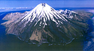
Geological Summary. Symmetrical Kanaga stratovolcano is situated within the Kanaton caldera at the northern tip of Kanaga Island. The caldera rim forms a 760-m-high arcuate ridge south and east of Kanaga; a lake occupies part of the SE caldera floor. The volume of subaerial dacitic tuff is smaller than would typically be associated with caldera collapse, and deposits of a massive submarine debris avalanche associated with edifice collapse extend nearly 30 km to the NNW. Several fresh lava flows from historical or late prehistorical time descend the flanks of Kanaga, in some cases to the sea. Historical eruptions, most of which are poorly documented, have been recorded since 1763. Kanaga is also noted petrologically for ultramafic inclusions within an outcrop of alkaline basalt SW of the volcano. Fumarolic activity occurs in a circular, 200-m-wide, 60-m-deep summit crater and produces vapor plumes sometimes seen on clear days from Adak, 50 km to the east.
Information Contacts: Alaska Volcano Observatory (AVO), a joint program of theUnited States Geological Survey (USGS), theGeophysical Institute of the University of Alaska Fairbanks (UAFGI), and theState of Alaska Division of Geological and Geophysical Surveys (ADGGS), Anchorage, AK (URL: http://www.avo.alaska.edu); Christina A. Neal, USGS/AVO Anchorage, AK (URL: http://www.avo.alaska.edu); NASA Earth Observatory (URL: http://earthobservatory.nasa.gov/).