Report on Azufral (Colombia) — March 2013
Bulletin of the Global Volcanism Network, vol. 38, no. 3 (March 2013)
Managing Editor: Richard Wunderman.
Edited by Julie A. Herrick.
Azufral (Colombia) Expanded monitoring efforts and explosive hydrothermal event in July 2009
Please cite this report as:
Global Volcanism Program, 2013. Report on Azufral (Colombia) (Herrick, J.A., and Wunderman, R., eds.). Bulletin of the Global Volcanism Network, 38:3. Smithsonian Institution. https://doi.org/10.5479/si.GVP.BGVN201303-351090
Azufral
Colombia
1.08°N, 77.68°W; summit elev. 4070 m
All times are local (unless otherwise noted)
Previously reported activity from Azufral included seismic swarms in 1971 (CSLP 43-71) and fluctuating conditions within the crater lake, Laguna Verde during July-August 1990 (BGVN 15:08) (figure 1). In this report, we highlight explosive hydrothermal activity that occurred during July-August 2009. We also provide observations of Azufral's hydrothermal and fumarolic activity and review monitoring efforts that expanded since 2005.
 |
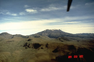
Figure 1. Looking E from Azufral's crater rim, the moat-like Lake Verde encloses nearly half of the central dome complex. The pale dome rock at the far left side of the lake was also the location of small fumarolic vents. While the lake level has fluctuated by ~1 m (gradual change over months), the bright green color persisted. This photo was taken on 4 September 2008 at 1210 by Servicio Geológico Colombiano (SGC) technicians. |
Fumarolic activity within Azufral's largest crater had long been observed by Colombia's earliest inhabitants and investigators including Alexander von Humboldt in the 1800s (Yudilevich Levy, 2004). In one of his many journals, Diario VII "Viaje de Pasto a Quito," this naturalist noted the rugged morphology of the edifice, describing it as a volcano that had broken apart; similar in appearance to Sotará, a volcano he had already visited. At the time of his visit in December 1801, there were significant deposits of sulfur and strong gas emissions within the crater, particularly around the largest crater lake (he noted that there were several craters in the complex, the largest now known as Laguna Verde).
"Una de estas bocas es una charca hirviente de azufre, parecida al de Puracé, de furioso estrépito. Los vapores de azufre se escapan, además, de la tierra húmeda arcillosa y arrojan el lodo a lo alto, como si fuesen cañones." (Yudilevich Levy, 2004, p. 74).
With the assistance of Rüdiger Escobar-Wolf (Michigan Technological University), we translated the above passage as follows. Note that the works of von Humboldt were originally written in German.
"One of the depressions [of Azufral] contains a pond boiling and churning with sulfur, similar in appearance and furiously loud noises to the one at Puracé volcano. Sulfur vapors were also escaping from the clayey, humid earth, throwing the mud high in the air as if fired from cannons."
Local inhabitants shared their observations with von Humboldt, mentioning ash plumes (termed "polvo" in the diary), mud explosions, boiling water, and flames (sometimes starting brush fires) (Yudilevich Levy, 2004).
Explosive volcanic activity at Azufral had not been observed recently (a hydrothermal event was observed in July 2009, see the subsection below), but the geologic record has preserved evidence of large-scale eruptions dating from 2,095-950 BC (Siebert and others, 2010). In the January 2009 Technical Bulletin, the Servicio Geológico Colombiano (SGC) described Azufral as one of the most explosive volcanoes in Colombia due to its extensive pyroclastic and surge deposits.
Research by Hall and Mothes (2008) assessed Holocene volcanism and its impact on pre-Columbian indigenous cultures within the Interandean Valley. They synthesized the region's pyroclastic deposits (including source locations and event magnitudes) and highlighted the wide distribution of Azufral's deposits (figure 2). They argued that despite the extensive lahar and debris avalanche deposits within the valley, "the greatest impact upon mankind was probably not these short-lived violent events, but rather the burying of settlements and agricultural fields by ash fallout, the effect of which may have lasted hundreds of years. Ash fall layers are observed in pre-Columbian cultural horizons in the soil profile, occurring in the Interandean Valley, the lower flanks of the Andes, and along Ecuador's Pacific coast..."
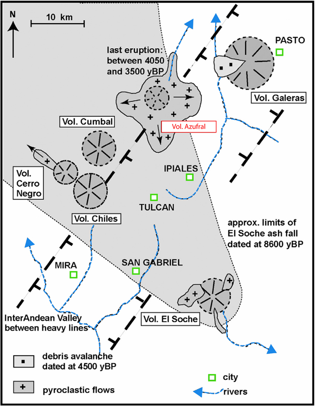 |
Figure 2. This regional map of Colombia's southern-most volcanoes includes the volcano El Soche, located in Ecuador and the distribution of Holocene volcanic products. Eruptions from Galeras, Azufral, Cumbal, Cerro Negro, Chiles, and El Soche have affected the NE-trending Interandean Valley (heavy dashed lines with hachure indicating downslope sides). Black arrows indicate directions of pyroclastic flows. Note that a ~930 BC (~2,900 ybp) date for Azufral's deposits is also cited by Siebert and others (2010); see the Geologic Summary. This map was modified from Hall and Mothes (2008). |
Monitoring efforts 2005-2013. The base of operations for monitoring Azufral has been located in Pasto (~48 km ENE of Azufral) since ~2005. Over time, the Servicio Geológico Colombiano (SGC), formerly known as Instituto Colombiano de Geología y Minería (INGEOMINAS), expanded monitoring capabilities at Azufral through instrumentation and field investigations (table 1, figure 3).
Table 1. Azufral's monitoring network in March 2013 included EDM, seismometers, tiltmeters, a video camera, and a wind station. Figure 3, below, shows a map of various sites. Courtesy of SGC.
| Station Description | Instrument Location(s) |
| Electronic Distance Meter (EDM) survey stations | 12 reflectors; 4 base stations (see figure 14) |
| Seismic stations (telemetered) | Chaitán, ~4 km ENE (broadband); Laguna, 0.5 km SW (broadband); La Roca, 1.2 km E (short period) |
| Electronic tilt station (telemetered) | Chaitán, ~4 km ENE; La Roca, 1.2 km E |
| Web camera (telemetered) | Laguna, 0.5 km SW |
| Weather station (wind and precipitation) | La Roca, 1.2 km E |
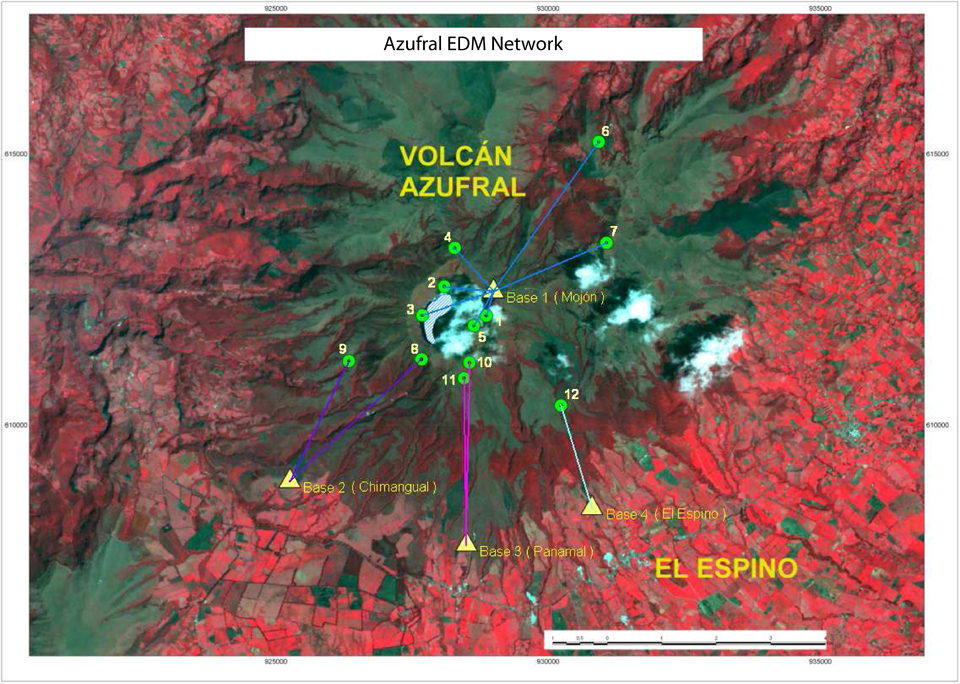 |
Figure 3. Map of Azufral's EDM network from the March 2013 Technical Bulletin. Courtesy of SGC. |
Aerial observations had been conducted since 2005 focusing primarily on the lake's characteristics such as color, water level, and shoreline morphology. Overflights with a thermal camera were conducted during 2007-2011; during that time period, the maximum surface temperatures ranged from 22.5-38°C.
Changes in the lake level were observed based on repeat aerial photos; in particular, between 5 December 2006 and 23 August 2009, Laguna Verde had a noticeably narrower shoreline, suggesting that the lake volume had increased.
Field investigations established baselines for lake chemistry, diffuse radon gas emissions, SO2 flux within the crater, thermal emissions from fumarolic sites, EDM measurements, and the geochemistry of four local hot springs (figure 4).
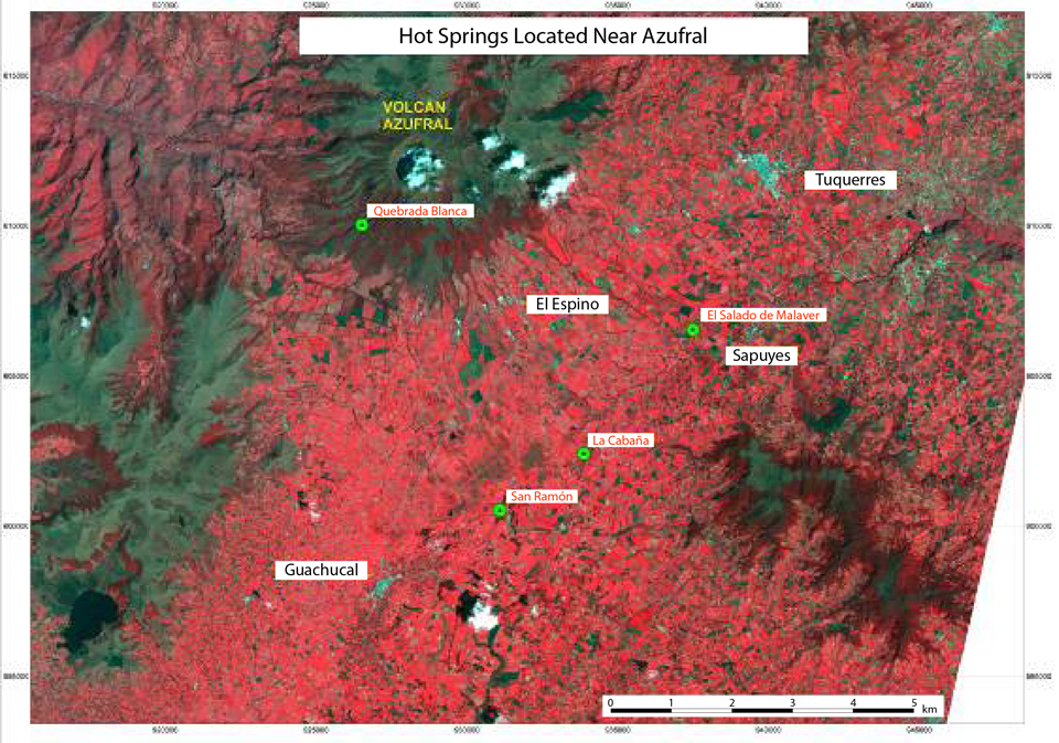 |
Figure 4. A map of hot spring locations within the region of Azufral (green circles with red text). Data from regular monitoring efforts was available between May 2010 and April 2013. Major local towns are labeled with black text. Courtesy of SGC. |
During 2007-2008, SGC expanded the monitoring network by installing telemetered seismic stations and tiltmeters (figure 5). In the second quarter of 2008, the first monitoring stations were installed at Azufral; this timing coincided with monitoring developments at the neighboring volcanoes Doña Juana and Cumbal (volcanoes also managed by the Pasto Volcanological and Seismological Observatory, OVSP).
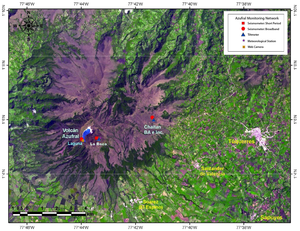 |
Figure 5. The monitoring network at Azufral as of April 2013 included three sites, Laguna, La Roca, and Chaitán where seismometers, tiltmeters, a meteorological station, and a web camera were installed. Courtesy of SGC. |
Seismicity 2009-2011. When Azufral's seismic stations came online in 2009, SGC began characterizing seismicity as volcano-tectonic (VT), long period (LPS), hybrid (HYB), tremor (TRE), tornillo (TOR), and unclassified (VOL). The VOL category, sometimes noted as "VC" in their reports, includes earthquakes from the region of Azufral that do not correspond with the other classes. SGC stated that these events will be analyzed in more detail after more baseline data is collected. This category was also applied to seismic analyses of Cumbal and Doña Juana, volcanos that were instrumented around the same time.
Unclassified seismicity (VOL) dominated the records through 2011, however, as SGC established baseline data, events falling in this category generally decreased over time. Total seismicity was also decreasing. During 2010-2011, tremor (TRE) and hybrid (HYB) events became sporadic to nonexistent.
During 5-6 February 2010, a seismic swarm was detected (figure 6). During January 2010-March 2013, this was the only swarm noted in the SGC Technical Bulletins. In early February 2010, two seismic stations were operating; Chaitán and La Roca. Unlike the Chaitán station, La Roca had broadband capabilities. "Broadband, high-dynamic-range seismometers are particularly important because existing instruments always saturate for large eruptions, and because energy at long periods (>>1 s) is simply not seen on standard short-period seismometers" (McNutt, 2000).
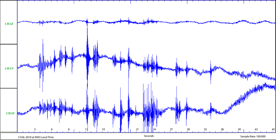 |
Figure 6. This seismogram from Azufral shows the onset of a seismic swarm at 0935 on 5 February 2010 from the Chaitán short period station. Three components (vertical, Z (top); N-S horizontal (middle); and E-W horizontal (bottom)) recorded the motion during this 45 second interval. Courtesy of SGC. |
During April 2010, the highest number of earthquakes was detected (493 events); most of those events were VOL and LPS (table 2). Seismicity also increased in September (228 events); however, they were primarily VOL earthquakes.
Table 2. Azufral's seismicity from December 2009 to December 2011. No tornillo events were detected during this time period. For most of 2009, seismic station Chaitán was not fully functional. Abbreviations explained in text; "--" indicates intervals when the category was not included in the Technical Bulletins. Courtesy of SGC.
| Month | VT | LPS | HYB | TRE | VOL | Total |
| Dec 2009 | 68 | 15 | 1 | 23 | -- | 107 |
| Jan 2010 | 2 | 3 | 0 | 3 | 0 | 8 |
| Feb 2010 | 47 | 125 | 2 | 48 | 95 | 317 |
| Mar 2010 | 20 | 25 | 0 | 18 | 80 | 143 |
| Apr 2010 | 28 | 125 | 1 | 34 | 305 | 493 |
| May 2010 | 23 | 45 | 0 | 14 | 97 | 179 |
| Jun 2010 | 18 | 21 | 0 | 2 | 140 | 181 |
| Jul 2010 | 36 | 29 | 0 | 15 | 119 | 199 |
| Aug 2010 | 11 | 9 | 0 | 0 | 83 | 103 |
| Sep 2010 | 12 | 6 | 0 | -- | 210 | 228 |
| Oct 2010 | 23 | 17 | 0 | -- | 179 | 219 |
| Nov 2010 | 21 | 11 | 0 | -- | 72 | 104 |
| Dec 2010 | 26 | 3 | 0 | -- | 93 | 122 |
| Jan 2011 | 32 | 21 | 0 | -- | 93 | 146 |
| Feb 2011 | 30 | 2 | 0 | -- | 109 | 141 |
| Mar 2011 | 14 | 23 | 0 | -- | 68 | 105 |
| Apr 2011 | 29 | 20 | 0 | -- | 86 | 135 |
| May 2011 | 11 | 1 | 0 | -- | 40 | 52 |
| Jun 2011 | 18 | 9 | 1 | -- | 30 | 58 |
| Jul 2011 | 20 | 3 | 0 | -- | 21 | 44 |
| Aug 2011 | 4 | 0 | 0 | -- | 10 | 14 |
| Sep 2011 | 4 | 1 | 0 | -- | 14 | 19 |
| Oct 2011 | 8 | 2 | 1 | -- | 12 | 23 |
| Nov 2011 | 12 | 7 | 3 | -- | 33 | 55 |
| Dec 2011 | 13 | -- | -- | -- | 22 | 35 |
Overall 2011 seismicity averaged ~69 events per day (table 2). Earthquakes occurred more frequently earlier in the year; during January-May they averaged 116 events per month compared with 35 per month during June-December.
On 20 July 2011 at 0353, an earthquake was felt by local populations, particularly in the town of El Panamal (~5 km SW). The event was an ML 3 at 12.8 km depth (measured relative to the summit) and epicenter at 9.5 km SW. This was the only located earthquake that month; at that time, two seismic stations were operating (Chaitán and La Roca).
Seismicity in 2012-2013. In 2012, 5-45 VT earthquakes were recorded per month and 1-19 were located (table 3). At 19:41 on 4 May 2012, an earthquake was felt by local populations in Túquerres, San Roque, and Sapuyes (for town locations, see figure 3). It was an ML 3.3 with an epicenter ~12.2 km of Azufral at a depth of 8.64 km. The maximum intensity of shaking was III on the Modified Mercalli scale.
Table 3. Seismicity at Azufral from January 2012 through April 2013. Note that depths of events are measured relative to the established summit elevation (4,070 m elevation). Courtesy of SGC.
| Month | VT | VT Located | VT ML | VT Depths | VT Epicenter | VOL | Total |
| Jan 2012 | 19 | -- | -- | -- | -- | 15 | 34 |
| Feb 2012 | 45 | -- | -- | -- | -- | 20 | 65 |
| Mar 2012 | 10 | -- | -- | -- | -- | 5 | 15 |
| Apr 2012 | 20 | -- | -- | -- | -- | 3 | 23 |
| May 2012 | 14 | 2 | 3.3; 1.7 | 8.6 km; 7.4 km | 12.2 km E; 6 km NW | 1 | 15 |
| Jun 2012 | 6 | -- | -- | -- | -- | 1 | 7 |
| Jul 2012 | 5 | 1 | 1.4 | 15 km | 3.4 km NE | 2 | 7 |
| Aug 2012 | 7 | -- | -- | -- | -- | 0 | 7 |
| Sep 2012 | 9 | 2 | 2.1; 2.9 | ~6 km; ~14 km | 10 km SE; 14 km E | 0 | 9 |
| Oct 2012 | 42 | 19 | 0.5-2.1 | < 16 km | 1.5-15 km E | 8 | 50 |
| Nov 2012 | 22 | 2 | 0.6-0.7 | < 2 km | 4 km NE; 11 km NE | 5 | 27 |
| Dec 2012 | 24 | 1 | 0.8 | 16 km | 10.4 km NE | 50 | 74 |
| Jan 2013 | 15 | 1 | 1.1 | 4.7 km | 2.5 km N | 9 | 24 |
| Feb 2013 | 15 | 6 | 0.3-1.9 | 2.5-15 km | < 1-< 11 km | 6 | 21 |
| Mar 2013 | 16 | 2 | < 1.3 | 5.4 km; 7.3 km | 7 km S; 3.5 km N | 0 | 16 |
| Apr 2013 | 39 | 26 | < 2.1 | < 11 km | 4-10 km dispersed | 15 | 54 |
During 2012, the largest number of located earthquakes occurred in October 2012. Located earthquakes peaked later in April 2013. Of the 39 VT detected, 26 of these earthquakes were located, primarily in a scattered cluster ~8 km NW of the summit (figure 7).
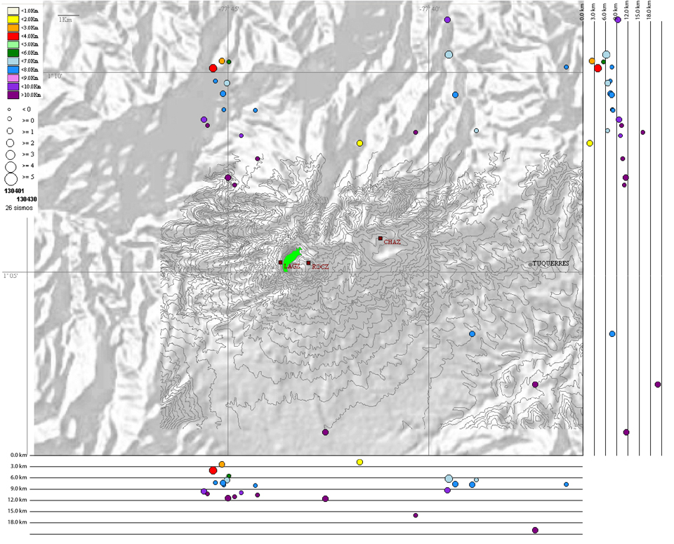 |
Figure 7. Map of the 26 located VT earthquakes at Azufral during April 2013 (see key at upper left). Three seismic stations (gray squares) were online near the volcano: LAGZ (Laguna), ROCZ (La Roca) and CHAZ (Chaitán). The vertical cross-sections (N-S and E-W) have depths measured in 3 km intervals. Note that the original topographic contours are aligned with a hillshade image of the region. Courtesy of SGC. |
Field observations in 2008 and mid-2009. During geophysical campaigns carried out in 2008 by SGC (then INGEOMINAS), fumarolic activity was observed from one of its domes, Domo Pequeño, in an area lacking vegetation. That location was also known for sulfur deposits, causing the surface to appear greenish-yellow; sulfur odors could were also detected. Bubbles in Laguna Verde were also apparent, rising from deep in Laguna Verde.
Aerial photos taken on 13 April 2009 showed clear views of the pale dome rock and bright green lake. A visit on 23 June 2009, revealed a zone of cloudy water in the green lake; low-level fumarolic activity was also observed (figure 8).
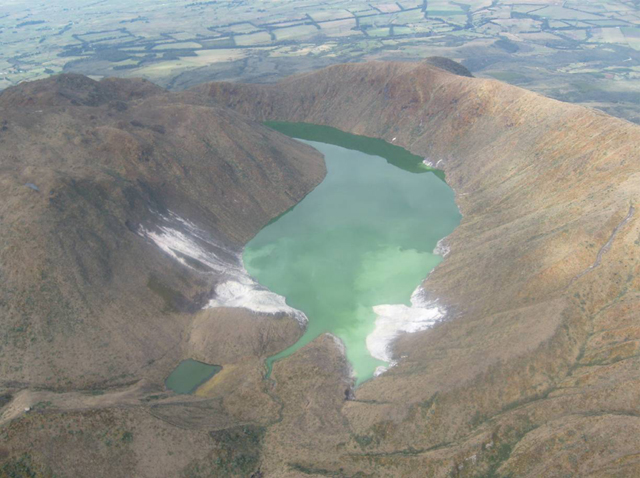 |
Figure 8. Azufral's Laguna Verde as seen on 23 June 2009 during a visit made possible by the Colombian Air Force (FAC). Look direction is approximately SW. The typically green lake contained anomalous cloudy features. Dome rock and sulfur deposits are located within the white areas along the shoreline, particularly within an area known as La Playa (the narrow white peninsula on the lake's NE side, the right-hand side of the photo). The smallest pond (lower left-hand side) is referred to as Laguna Barrosa/Laguna Cristalina; out of view to the left is a smaller pond known as Laguna Negra. Courtesy of SGC. |
Hydrothermal explosion in July 2009. SGC technicians had visited Azufral on 12 July 2009 to take water samples for analysis, but a group of scientists visiting on 18 July were surprised by a sudden change within the crater. They discovered a new deposit, 8-10 m long extending from the fumarolic region known as La Playa; the deposits were described as hot and they had extended into the lake. The SGC surmised that the activity must have occurred between the 13 and 18 July 2009. The group determined that this was an eruptive process likely of hydrothermal origin. The visiting scientists (from Fundación Ambiental Andes) reported observations including fresh-looking cracks and several slope failures which had allowed hot fluids to escape; those areas continued to steam during their visit (figure 9).
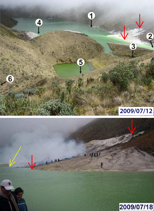 |
Figure 9. The NE end of Azufral's Laguna Verde was visited twice in July 2009 by field investigators and led to the discovery of newly erupted deposits. Red arrows indicate the extent of the area known as La Playa in both images. (Top) On 12 July SGC scientists visited the lake shore and sampled the water at six locations (numbered locations in white circles). The rounded dome in the center has been referred to as "Domo Pequeño" and was the location of persistent fumarolic activity. Courtesy of SGC. (Bottom) On 18 July, visitors from the Fundación Ambiental Andes encountered persistent steam rising from a fresh deposit of dark, dense material that extended into Laguna Verde (yellow arrow) from La Playa. They noted fresh cracks and deposits within this area already known for altered rock and sulfur deposits. Photo by Oliver Oviedo. |
In looking for monitoring signals during 13-18 July, SGC found that seismic and tilt data lacked clear elevated activity in July 2009; there were few earthquakes and mainly minor changes detected by the tilt instruments at Chaitán). Looking in more detail, the tilt station recorded some variations during 12-23 July, particularly from the X component (radial to the crater lake) (figure 10). A total decrease of 45 µrad was recorded while the Y component (tangential to the crater lake) was relatively stable with a slight increase of ~10 µrad and temperatures were between 6.5 and 9°C.
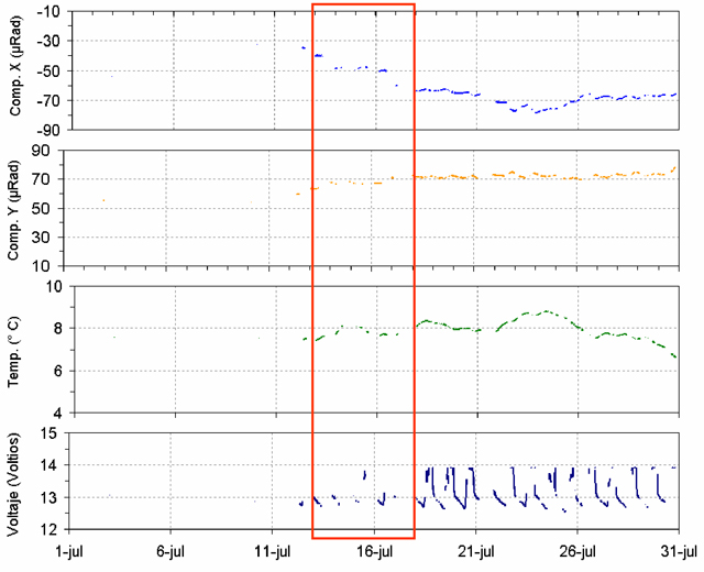 |
Figure 10. Variations at the Chaitán tilt station during July 2009 correlated with the time period when Azufral's hydrothermal event occurred during 13-18 July (within the red rectangle). The strongest signal was recorded by the x-component (radial to the crater lake) although the decreasing trend continued until ~24 July; the y-component (tangential to the crater lake) responded less robustly but the main offset was confined to the 13-18 July window. The lower two plots show the instrument area's temperature and battery voltage. Courtesy of SGC. |
August 2009 field investigations. On 3 August, a local observer noted unusual activity while walking along the higher peaks of Azufral; he stated that he saw "material being set on fire in the beach of Azufral and there were gases smelling like sulfur." A local landowner also explained that hot springs could be found ~6.5 km away at a site called Tutachag; these springs had persisted for several months. SGC alerted the local disaster prevention representative (Comité Regional de Prevención y Atención de Desastres de Nariño, CREPAD-N) after receiving the report of these observations; the CREPAD-N is responsible for communicating with local residents and visitors who frequent sites around Azufral.
During field investigations on 18 August, SGC staff learned from an additional local inhabitant (from the town of San Roque Alto) that, while walking the road to La Palma early in the morning of 3 August, he thought there was a fire on La Playa, possibly started by tourists. The fire was blue and red (although mostly blue) and gray smoke was rising, sometimes dense gray; he also noted sulfur odors.
After reviewing the seismicity during the first week of August 2009, SGC staff noted small events had been detected by the Chaitán station. At that time, seismic monitoring was not robust enough to provide earthquake locations, but the records determined that low pulses of spasmodic tremor had occurred in the range of 6-12 Hz and 12-18 Hz, lasting up to 4 minutes. LP events were also apparent in the record.
On 19 August, visiting scientists noted increased bubbling from more locations within Laguna Verde; primarily around the N shore of the lake. Few emissions were observed from the La Playa area; however, they noted intermittent sulfur odors while they conducted fieldwork.
SGC scientists traversed the NE shoreline with a FLIR (Forward Looking Infrared) thermal camera. The temperatures reached a maximum of 57.9°C along the N shore of La Playa (figure 11). Maximum temperatures corresponded with known locations of past hydrothermal activity.
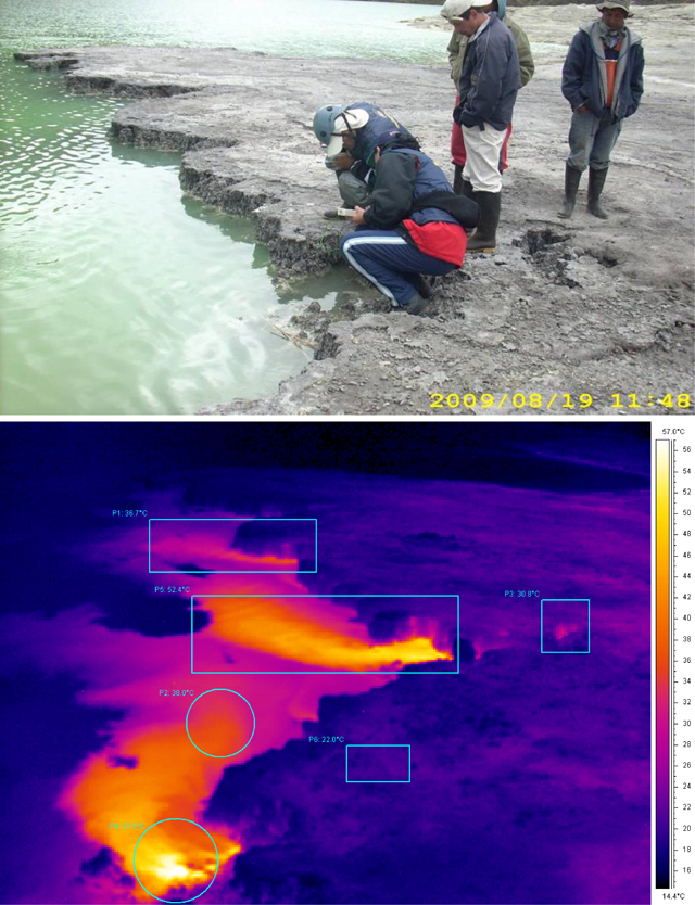 |
Figure 11. SGC scientists visited Azufral on 19 August 2009 to monitor changes in the hydrothermal system and to install additional equipment. (Top) Installation of a radon trap (Rn222) along the N shore of La Playa. The analysis conducted that day determined significant amounts of diffuse radon emissions from the central collapse zone on La Playa (641 pCi/L; see the middle photo of figure 12 for this location) and from the shoreline of the new peninsula (311 pCi/L). (Bottom) At the same location as the top photo, the FLIR camera detected the highest temperatures in the water closest to the shoreline (up to 57.9°C). Rectangles and circles highlight selected temperatures. Courtesy of SGC. |
On 19 August, SGC scientists measured SO2 emissions along a traverse with Mobile DOAS. The team followed ~50 m of the shore and calculated an average flux of 0.5 tons per day, a value considered relatively low. They noted that the wind was from the N at 2.5 m/s.
Samples of the deposits attributed to the 13-18 July event on La Playa were distinctively cemented and possibly rich in silica and alteration minerals (figure 12). The SGC scientists collected samples for lab analysis including x-ray diffraction (XRD). Two samples were analyzed at SGC laboratory in Cali where XRD determined abundant (>40%) sulfur was present; amorphous silica (opal) was sparse (3-10%) and trace quantities (
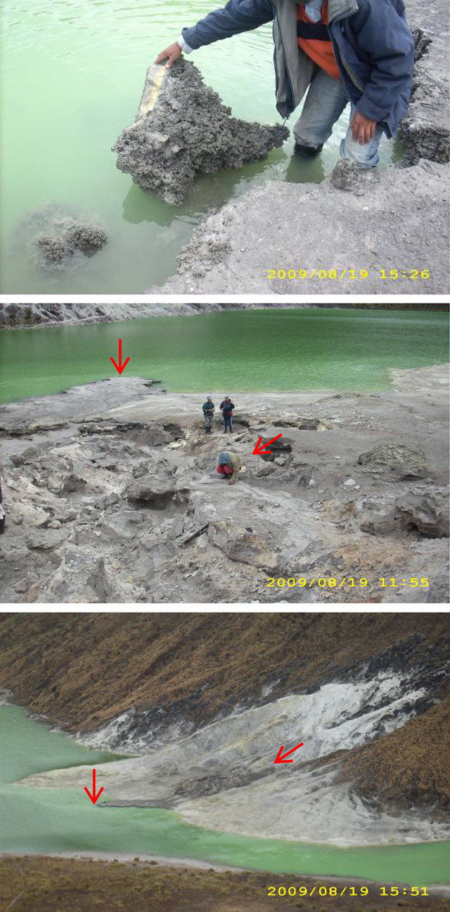 |
Figure 12. This series of photos from 19 August 2009 shows where the 13-18 July deposit had formed a dark gray peninsula jutting from the La Playa shore into Laguna Verde. (Top) A scientist inspects a slab broken from the peninsula. The thin gray deposit had a rugged surface but also a planar contact with the underlying (yellow) material. (Middle) A view of the flowpath that emerged at a series of depressions located upslope from the lake's edge. SGC described these new features as circular collapses 17-20 m wide and cut by many groundcracks. Temperatures measured with the FLIR were in range of 19-40°C for this region. The red arrows mark the extent of the new deposit, starting at the point where scientists were observing groundcracks. The look direction is approximately SSE. (Bottom) A view of the La Playa region centered on the disturbed area where dark gray material was deposited in the middle ground (during 13-18 July 2009) and extended into the lake forming a small peninsula. The red arrows are consistent with the previous photo where they mark the long extent of the new deposit. The look direction is approximately NW. Courtesy of SG. |
On 30 August an experiment was conducted with small fragments of this material. In a lab setting, SGC scientists demonstrated that the material was flammable and produced heat and sulfur odors that stung the eyes and nose; red and blue flames were also observed immediately when the fragments encountered an open flame (tested with a lighted match). After a few seconds of exposure to an open flame, the samples melted and immediately crumbled into an inert, brittle solid. This demonstration may explain the explosive phenomena that local inhabitants observed on 3 August 2009.
Aerial observations during August-December 2009. During 11 and 19 September, the FAC facilitated observations of Azufral. Photographs and thermal imagery revealed few changes. The highest temperatures detected were in range of 25 to 30°C. The largest region of thermal anomalies was located on the opposite shore from La Playa (figure 13), a region where dacitic domes have been known to emit steam and have sulfur deposits.
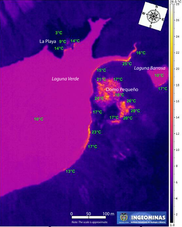 |
Figure 13. This FLIR image of Azufral's crater lake from 19 September 2009 shows elevated temperatures along the shoreline of Laguna Verde, Laguna Barrosa, and the dacitic domes on the E side of the lake. The distance scale is an approximation; the color scale on the right was adjusted for visual effects and records between 1 and 28°C. The highest temperatures in view were between 25 and 28°C. Courtesy of FAC and SGC in collaboration with Germany's Federal Institute for Geosciences and Natural Resources (BGR). |
A return trip to Azufral during 7-11 December 2009 determined that some emissions were visibly rising from the dome located on the E side of Laguna Verde (figure 14). A maximum temperature measured from the dome was 85°C. SGC scientists also measured concentrations of CO2 higher than 10,000 ppm from fumarolic sites.
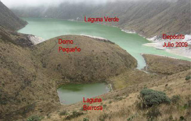 |
Figure 14. An annotated photo taken on 9 December 2009 by visiting scientists in the NE sector of Azufral. Notable emissions were rising from the dome labeled "Domo Pequeño." Courtesy of SGC. |
Emission sites were also revisited along La Playa on 9 December. Temperatures measured with a thermocouple were in the range of 65-84°C. Those temperatures were measured at locations that had elevated temperatures when last measured with a FLIR. CO2 emissions from these zones reached 3,200 ppm.
2010-2012 monitoring highlights. Routine monitoring from January 2010 to 2012 included sampling Laguna Verde at several locations as well as sampling the local hotsprings (figure 4). By October 2010, a baseline of geochemical data was developed by SGC and the four distal hot springs were evaluated and characterized as primarily mature-to-peripheral water (figure 15).
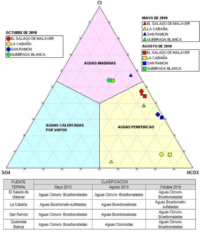 |
Figure 15. Regular sampling of four local hot springs located within 5 km of Azufral was conducted in May (triangles), August (squares), and October 2010 (circles). Based on geochemical results, SGC scientists classified four of Azufral's hot springs. Within this ternary diagram, the datapoints were generally well within the "Periferal Water" (Aguas Periféricas, significant HCO3) class. Some datapoints from Quebrada Blanca and San Ramon were within the "Mature Water" class (Aguas Maduras, significant Cl); no datapoints were within the "Volcanic Water" class (Aguas Calentadas por Vapor, significant SO4) class. Courtesy of SGC. |
Monitoring temperatures from Laguna Verde and selected sites also continued during 2010-2012. SGC scientists frequently conducted traverses along the shore with a thermocouple and established baseline temperature data (figure 16).
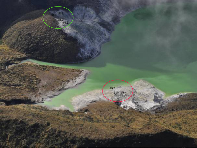 |
Figure 16. On 18 March 2011, SGC measured temperatures from Azufral's shoreline and fumarolic sites. Temperatures were highest (86.8°C, 86.4°C, 86°C, and 85.2°C) near the crest of Domo Pequeño (circled in green). Temperatures 76°C and 75.2°C (circled in red) were measured from a fumarolic site and water near the shore of La Playa (respectively). Look direction is approximately SW. Courtesy of SGC. |
During field campaigns, SCG staff noted variable emissions from fumarolic sites, clustering of bubbles within Laguna Verde, and also changes in the lake level. To aid visual monitoring, a web camera was installed within the crater of Azufral on 24 November 2012 (figure 17). The camera was positioned to include a wide view of Domo Pequeño (a regular source of steam emissions) and La Playa (the location of the hydrothermal event in July 2009).
 |
Figure 17. The new webcamera captured a small, diffuse steam plume rising from Azufral's Domo Pequeño on 29 November 2012. The look direction is approximately NE. Courtesy of SGC. |
References. Hall, M.L and Mothes, P.A., 2008. Volcanic impediments in the progressive development of pre-Columbian civilizations in the Ecuadorian Andes, Journal of Volcanology and Geothermal Research, 176, 344-355.
McNutt, S.R., 2000, Volcanic seismicity. In: Sigurdsson, H., ed., Encyclopedia of volcanoes. New York, Academic Press, p. 1,015-1,033.
Siebert, L., Simkin, T., Kimberly, P., 2010, Volcanoes of the World, 3rd edn. University of California Press, Berkeley.
Yudilevich Levy, D., 2004, Mi viaje por el camino del Inca (1801-1802): Antología, 1a. ed., Editorial Universitaria, S.A., Santiago, Chile [in Spanish].
Geological Summary. Azufral stratovolcano in southern Colombia, also known as Azufral de Túquerres, is truncated by a 2.5 x 3 km caldera containing a Holocene rhyodacitic lava-dome complex. A crescent-shaped lake, Laguna Verde, occupies the NW side of the caldera. Nearly a dozen lava domes are present, the latest of which were formed about 3600 years ago and have active fumaroles. Azufral rocks are more silicic than those of nearby Colombian volcanoes; an apron of rhyodacitic pyroclastic-flow deposits rings the volcano. The last known eruption took place about 1000 years ago.
Information Contacts: Servicio Geológico Colombiano (SGC), Observatorio Vulcanológico y Sismológico de Pasto, Pasto, Colombia (URL: http://www.SGC.gov.co/Pasto.aspx); Patricia Ponce Villarreal, Servicio Geológico Colombiano (SGC), Observatorio Vulcanológico y Sismológico de Pasto, Pasto, Colombia (URL: http://www.SGC.gov.co/Pasto.aspx); Rüdiger Escobar-Wolf, Michigan Technological University, Department of Geological and Mining Engineering and Science, Houghton, MI, USA (URL: http://www.mtu.edu/geo/).