Report on Zubair Group (Yemen) — April 2013

Bulletin of the Global Volcanism Network, vol. 38, no. 4 (April 2013)
Managing Editor: Richard Wunderman.
Zubair Group (Yemen) Eruption on new island continues into January 2012
Please cite this report as:
Global Volcanism Program, 2013. Report on Zubair Group (Yemen) (Wunderman, R., ed.). Bulletin of the Global Volcanism Network, 38:4. Smithsonian Institution. https://doi.org/10.5479/si.GVP.BGVN201304-221020
Zubair Group
Yemen
15.05°N, 42.18°E; summit elev. 191 m
All times are local (unless otherwise noted)
In BGVN 36:11 we reported on an ongoing submarine eruption in the N portion of Yemen's Zubair group of islands in the Red Sea that [produced visible activity on 18 December 2011]. A new island emerged in this vicinity and was large enough to resolve in satellite imagery by 23 December 2011. The latitude and longitude given in the header for this report is for the volcanic island of Jebel Zubair (15.05°N, 42.18°E), the largest island of the Zubair Group (figure 5). The new island emerged approximately 15.158°N, 42.101°E, or ˜10 km NW off the NW coast of Jebel Zabair. A bathymetric sketch map made in 1973 indicated a water depth of about 100 m in that area. The S end of the new island is about 500 m NNW of Rugged Island.
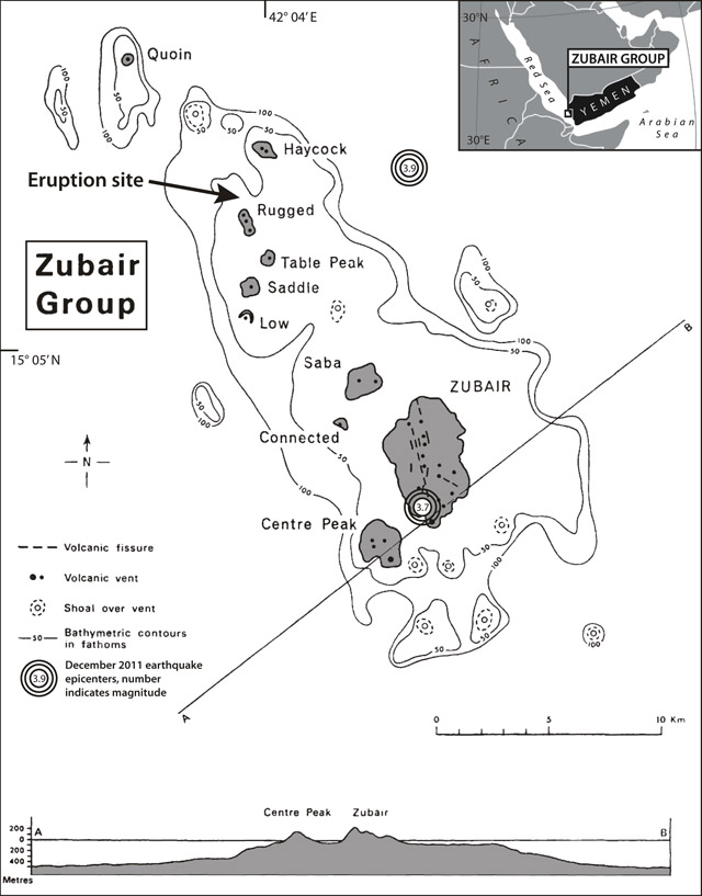 |
Figure 5. Map and index map of the 10 islands of the Zubair Group (Yemen) showing the site of the new eruption and its associated emergent island. Islands are represented by gray shading; other features are identified by the legend at left. The cross section at the bottom is along line A-B through the S portion of the group. Modified from Gass and others (1973); index map modified from MapsOf.net. |
By 7 January 2012, the island had grown to about 530 x 710 m, and a gas-and-steam plume containing ash rose from a distinct cone (figure 6). A video from a Yemeni miliary helicopter uploaded on YouTube on 2 January 2012 showed violent explosions typical of shallow submarine eruptions. The satellite image in figure 6 shows that a new island in the Zubair Group is the source of the volcanic plume.
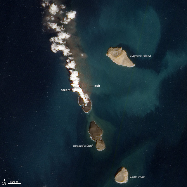 |
Figure 6. This satellite image, acquired 7 January 2012, shows that the island had risen above water. A plume of steam, other volcanic gases, and ash rises from a distinct cone. The land surrounding the vent had grown, and was about 530 by 710 m in dimension. Once above water, past eruptions in the Zubair Islands were primarily effusive, with low viscosity lava forming thin lava flows. This natural-color image was acquired by the Advanced Land Imager (ALI) aboard the Earth Observing-1 (EO-1) satellite. Courtesy of NASA Earth Observatory web site; image by Robert Simmon, using ALI data from the EO-1 Team; caption by Robert Simmon. |
Natural-color images from the Enhanced Thematic Mapper Plus (ETM+) on Landsat-7 on 15 January and 15 February 2012 show the new island, but no plume rising from it or any other indication of eruption continuing.
MODVOLC, using MODIS data from the Aqua satellite, measured a 2-pixel thermal anomaly at 2235 UTC, 11 January 2012, at latitude 15.16°N, longitude 42.10°E, just S of Haycock Island. This was the only thermal alert measured in the area during the December 2011-January 2012 time period.
References: Gass, I.G., Mallick, D.I.J., and Cox, K.G., 1973, Volcanic islands of the Red Sea. Journal of the Geological Society of London, v. 129, no. 3, pp. 275-309.
Vervaeck, A., 2012 (17 January), Surtseyan eruption along the coast of Yemen forms a new island - January 15 new ALI satellite image, Earthquake newsreport web site (URL: http://earthquake-report.com/2011/12/29/surtseyan-eruption-along-the-coast-of-yemen-forms-a-new-island-today-eruption-cloud-stain); accessed 21 May 2013.
YouTube video uploaded by Naif8989889 on 2 January 2012, (http://www.youtube.com/watch?v=YoMLNEJC-Nk&feature=gu&context=G2d0c74aFUAAAAAAAAAA).
Geological Summary. The 5-km-long Jebel Zubair Island is the largest of a group of small islands and submerged shoals that rise from a shallow platform in the Red Sea rift. The platform and eruptive vents forming the islands and shoals are oriented NNW-SSE, parallel to the rift. An early explosive phase was followed by a brief period of marine erosion, then by renewed explosive activity accompanied by the extrusion of basaltic pahoehoe lava flows. This latest phase of activity occurred on the morphologically youngest islands of Zubair, Centre Peak, Saba, and Haycock. Historical explosive activity was reported from Saddle Island in the 19th century. Spatter cones and pyroclastic cones were erupted along fissures that form the low spine of Zubair Island. Eruptions that began in late 2011 built two new islands, increasing the total number in the group to 12.
Information Contacts: NASA Earth Observatory (URL: http://www.earthobservatory.gov).