Report on Suwanosejima (Japan) — April 2013
Bulletin of the Global Volcanism Network, vol. 38, no. 4 (April 2013)
Managing Editor: Richard Wunderman.
Suwanosejima (Japan) Near continuous tremor between July 2012 and March 2013
Please cite this report as:
Global Volcanism Program, 2013. Report on Suwanosejima (Japan) (Wunderman, R., ed.). Bulletin of the Global Volcanism Network, 38:4. Smithsonian Institution. https://doi.org/10.5479/si.GVP.BGVN201304-282030
Suwanosejima
Japan
29.638°N, 129.714°E; summit elev. 796 m
All times are local (unless otherwise noted)
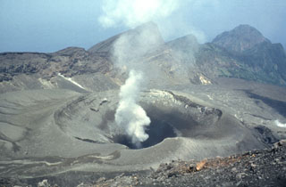
This report discusses Suwanose-jima (figure 16) during July 2012 through April 2013, an interval with generally abundant tremor, low numbers of earthquakes, weak plumes (less than 0.7 km above the crater rim), and occasional intermittent eruptions. Our previous report on Suwanose-jima discussed seismicity through June 2012 that included volcanic earthquakes and tremor, minor explosions, and plumes which occasionally deposited ash [in the residential area ~4 km SSW of the active crater, administratively part of the multi-island Toshima Village,] as late as June 2012 (BGVN 37:08).
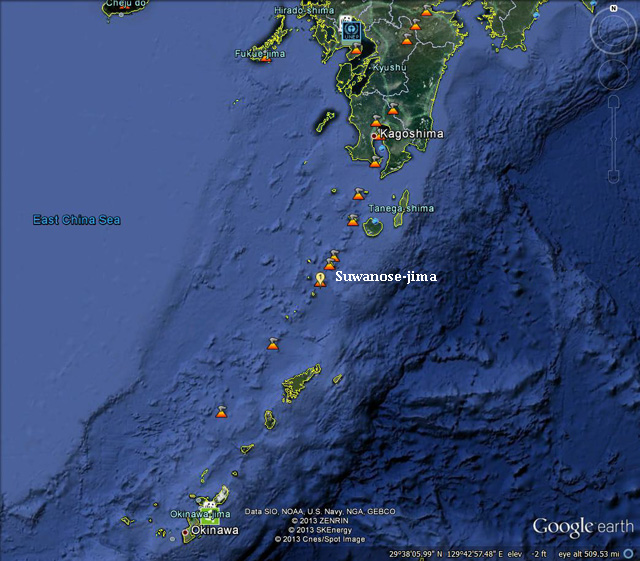 |
Figure 16. Satellite image showing the location of Suwanose-jima. Courtesy of Google Earth. |
Recent monthly reports of volcanic activity from the Japan Meteorological Agency (JMA) translated into English resumed in October 2010. Since June 2012, English-translated JMA reports on Suwanose-jima were available online every month through March 2013.
According to JMA, seismic activity at Suwanose-jima remained at low levels between July 2012 and March 2013. Although explosive eruptions have occurred repeatedly in the past, no such eruption occurred during the reporting period. However, JMA reported infrequent tiny eruptions. Volcanic tremor occurred almost continually between 28 September 2012 and March 2013. A high-sensitivity camera often detected a weak night glow during every month. No unusual ground deformation was seen in GPS observation data. Table 11 summarizes tremor activity and other information reported by JMA.
Table 11. A compilation of data on Suwanose-jima between July 2012 and March 2013. '--' indicates data not reported. A-type earthquakes are generally considered to have shallow focal depths; B-type earthquakes, deeper focal depths. An asterisk "*" in the earthquake column indicates that the number of events reported for a specific month conflicts with the number reported for that same month in the sequential monthly JMA report. Data courtesy of JMA.
| Month | Earthquakes | Tremor duration (hours:minutes) | Max plume height (m above crater rim) | Comments |
| Jul 2012 | 29 A-type events, 123 B-type events | 38:5 | 400 | Eruption. |
| Aug 2012 | 17 A-type events, 39 B-type events (or 60 events)* | 0:0 (or 0:1)* | 300 | No eruption. Plume on 19 Aug only. |
| Sep 2012 | 37 A-type events, 86 B-type events (or 74 events)* | 0:1 (or 67:52)* | 300-400 | No eruption. White plumes. 11 Sep aerial observation spotted white plume above Otake crater. |
| Oct 2012 | 22 A-type events, 78 B-type events. | 705:19 | 700 | Tiny intermittent eruptions at Otake crater. According to Tokyo VAAC, an ash plume on 3 Oct drifted SW at altitude of 3 km (i.e. 1.5 km higher than the JMA reported). Ashfall [in the village], 4 km SSW of Otake, on 2 and 5 Oct. |
| Nov 2012 | -- | 720:0 | 500-600 | Tiny intermittent eruptions. Tiny amount of ashfall [in the village] on 25 Nov. |
| Dec 2012 | -- | 622:23 | 500 | Tiny intermittent eruptions on 26th, red hot mass seen. |
| Jan 2013 | -- | 744:0 | 500 | White plumes. |
| Feb 2013 | -- | 672:0 | 500 | M 3.6 earthquake on 19 Feb with aftershocks. Tiny intermittent eruption on 3 Feb. Tiny amount of ashfall [in the village] on 3 Feb. |
| Mar 2013 | -- | -- | 500 | Tremor data unavailable. |
| Apr 2013 | -- | -- | 700 | Small eruption on 13 April. Tremor data unavailable. |
On 8 November 2012, a field survey at Bunka crater revealed no remarkable change in the crater's shape. Infrared images showed no significant change in the crater's temperature distribution. On 26 December 2012, an aerial observation revealed a red-hot lava mass inside Otake crater. This phenomenon has occasionally been observed in past observations.
On 19 February 2013, a M 3.6 earthquake occurred (apparently at Suwanose-jima). The earthquake's maximum seismic intensity on JMA's scale was 3 (felt indoors by most or all people, objects rattle and fall off tables, houses shake strongly and may receive slight damage). In addition, a swarm of ten earthquakes (aftershocks?) with seismic intensities of 1 or greater on JMA's scale were recorded. These earthquakes caused no significant changes in surface phenomena or tiltmeter data. Seismicity remained at low levels, with hypocenters located just beneath the Otake crater.
Geological Summary. The 8-km-long island of Suwanosejima in the northern Ryukyu Islands consists of an andesitic stratovolcano with two active summit craters. The summit is truncated by a large breached crater extending to the sea on the E flank that was formed by edifice collapse. One of Japan's most frequently active volcanoes, it was in a state of intermittent Strombolian activity from Otake, the NE summit crater, between 1949 and 1996, after which periods of inactivity lengthened. The largest recorded eruption took place in 1813-14, when thick scoria deposits covered residential areas, and the SW crater produced two lava flows that reached the western coast. At the end of the eruption the summit of Otake collapsed, forming a large debris avalanche and creating an open collapse scarp extending to the eastern coast. The island remained uninhabited for about 70 years after the 1813-1814 eruption. Lava flows reached the eastern coast of the island in 1884. Only about 50 people live on the island.
Information Contacts: Japan Meteorological Agency (JMA), Otemachi, 1-3-4, Chiyoda-ku Tokyo 100-8122, Japan (URL: http://www.jma.go.jp/); Tokyo Volcanic Ash Advisory Center (VAAC), Tokyo, Japan (URL: http://ds.data.jma.go.jp/svd/vaac/data/).