Report on Sangeang Api (Indonesia) — July 2013

Bulletin of the Global Volcanism Network, vol. 38, no. 7 (July 2013)
Managing Editor: Richard Wunderman.
Sangeang Api (Indonesia) Fumarolic emissions and variable seismicity during 2012-2013
Please cite this report as:
Global Volcanism Program, 2013. Report on Sangeang Api (Indonesia) (Wunderman, R., ed.). Bulletin of the Global Volcanism Network, 38:7. Smithsonian Institution. https://doi.org/10.5479/si.GVP.BGVN201307-264050
Sangeang Api
Indonesia
8.2°S, 119.07°E; summit elev. 1912 m
All times are local (unless otherwise noted)
This Bulletin reports Sangeang Api activity since our last report of December 2009, (BGVN 34:12) until 1 November 2013. Sangeang Api volcano resides in the Flores Sea of Indonesia (figures 4 and 5). Several seismic events and corresponding white plumes were observed in 2012 and 2013. The Alert Level corresponding to the events were temporarily raised then lowered. The Alert Level scale extends from a low of 1 to a high of 5.
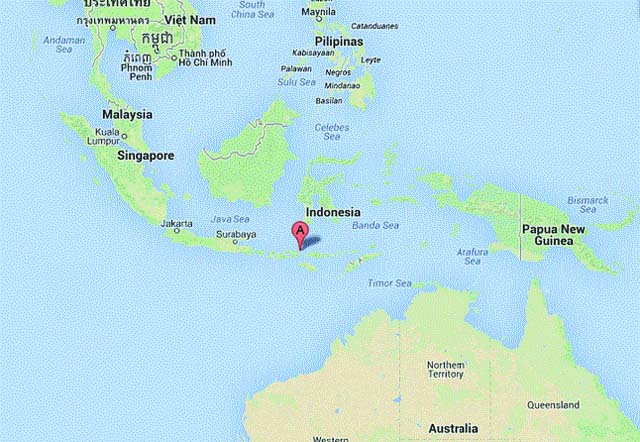 |
Figure 4. Sangeang Api volcano is on a 13-km-wide island of the same name located in the Lesser Sunda Islands of the Indonesian Archipelago. |
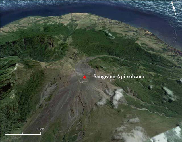 |
Figure 5. Sangeang Api seen in a N-looking view showing the summit area with active crater rim cut by the red triangle. A conspicuous older dormant crater lies NNE. Courtesy of Google Earth. |
The Indonesian government's Center for Volcanology and Geologic Hazard Mitigation (CVGHM) performs in situ visual, seismicity and satellite monitoring of Sangeang Api volcano and reports significant events. The same agency is also called Pusat Volkanologi dan Mitigasi Bencana Geolog - or PVMBG, a name that also appears on reports.
2009 - 2011 activity. Sangeang Api seismicity increased during May and June 2009 at the same time white plumes were observed with heights from 5 to 25 m. On 4 June 2009, CVGHM increased the alert level from 1 to 2 on the scale of 1 to 4. During 2010 and 2011 Sangeang Api reporting was unarchived on the web.
2012 activity. CVGHM reported that during 1-10 October 2012 Sangeang Api was often not visible due to fog; however when visible occasionally plumes were visible and rose as high as 20 m above the crater. The lava dome and surrounding areas had not changed compared to the beginning of the year. Both the number and magnitude of earthquakes increased on 5 October, declined during 6-8 October, then again increased on 9 October 2012. The Alert Level was raised to 3 on 10 October.
CVGHM issued an eruption warning on 12 October 2012 based on increased seismic activity. They commented that surface activity had not been detected so far, but a new eruption from the summit lava dome would not be a surprise. However, the hazard warning status definitions are not a robust basis for describing predictions.
CVGHM reported that during November through mid-December 2012 observers at the Sangeang, Bima District observation post (50 km SW) noted occasional diffuse white plumes rising 5-15 m above Sangeang Api's crater. The lava dome and surrounding areas had not changed compared to October observations. Avalanches had occurred on the W and SW flanks however their size was omitted. Earthquakes had declined. The Alert Level was lowered to 2 on 21 December.
2013 activity. CVGHM reported that 1-19 May 2013 diffuse white plumes rose 10 m above Sangeang Api's crater. Both the lava dome and surrounding areas showed no changes since November 2012. Seismicity had increased on 26 April 2013 which included 14 tremor events and remained high through June. From May through 13 June 2013 diffuse white plumes rose 10 m above Sangeang Api's crater. As many as 77 shallow earthquakes and 66 deep earthquakes had been detected daily (figure 6). The risk analysis by Surono (2013) noted that lava dome growth and avalanches had occurred on the W and SW flanks (figure 7). Note figure 3 seismicity records cease after 30 May 2013.
In June 2013, 15 shallow earthquakes and three deep earthquakes were detected. The Alert Level was lowered to 2 on 14 June. The public were advised not to approach the craters within a radius of 1.5 km.
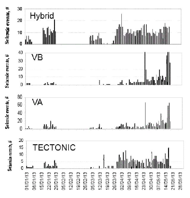 |
Figure 6. Sangeang Api seismicity registered during the period 1 January - 28 May 2013. Later reporting by CVGHM states shortly after this period the seismicity decreased and the alert level decreased. Courtesy of CVGHM. |
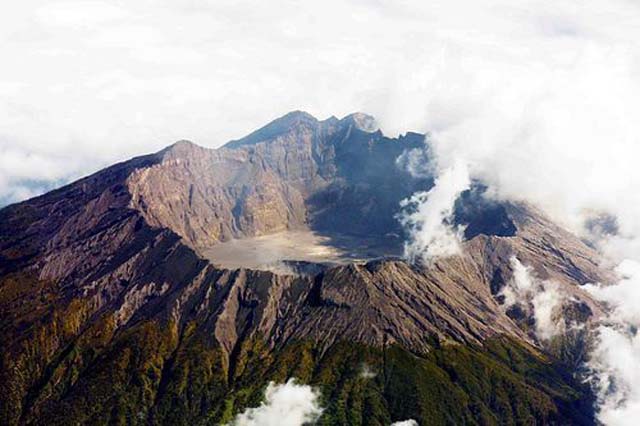 |
Figure 7. Sangeang Api volcano, which is truncated by a sharp rim and central crater. This image accompanied the CVGHM risk and situation summary power point update on 30 May 2013 for alert level 3 volcanoes. Date, location, look direction, and photographer unknown. Taken from Surono (2013). Courtesy of CVGHM. |
Reference. Surono (no first name), 5/30/2013 Risk and Situation Update Of Each Volcano Under Alert Level III, Ministry Of Energy and Mineral Resources, Indonesia https://docs.unocha.org/sites/dms/ROAP/Indonesia/Documents/PVMBG - VOLCANO_IN_LEVEL_III-30May2013.pdf
Geological Summary. Sangeang Api volcano, one of the most active in the Lesser Sunda Islands, forms a small 13-km-wide island off the NE coast of Sumbawa Island. Two large trachybasaltic-to-tranchyandesitic volcanic cones, Doro Api and Doro Mantoi, were constructed in the center and on the eastern rim, respectively, of an older, largely obscured caldera. Flank vents occur on the south side of Doro Mantoi and near the northern coast. Intermittent eruptions have been recorded since 1512, most of them during in the 20th century.
Information Contacts: Dali Ahmad, Center of Volcanology and Geological Hazard Mitigation (CVGHM), Jalan Diponegoro 57, Bandung 40122, Indonesia (URL: http://www.vsi.esdm.go.id/); and NASA Earth Observatory (URL: http://earthobservatory.nasa.gov/).