Report on El Misti (Peru) — July 2013
Bulletin of the Global Volcanism Network, vol. 38, no. 7 (July 2013)
Managing Editor: Richard Wunderman.
El Misti (Peru) Generally quiet; 1st small seismic swarm in 5 years during August 2012
Please cite this report as:
Global Volcanism Program, 2013. Report on El Misti (Peru) (Wunderman, R., ed.). Bulletin of the Global Volcanism Network, 38:7. Smithsonian Institution. https://doi.org/10.5479/si.GVP.BGVN201307-354010
El Misti
Peru
16.2991°S, 71.4056°W; summit elev. 5793 m
All times are local (unless otherwise noted)
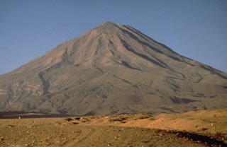
Since the last strong eruption in the 15th century, El Misti has experienced infrequent small explosions, some of which were probably merely heightened fumarolic activity. Our most recent reports discussed a steam emission in April 1984 (SEAN 09:05) and vigorous fumarolic activity during 7-8 August 1985 (SEAN 10:12). Weak fumaroles are occasionally detected at the summit area. This report presents basic background and some available recent seismic data through June 2013. Misti's location and its relationship with the nearby city of Arequipa is presented in figures 1-3.
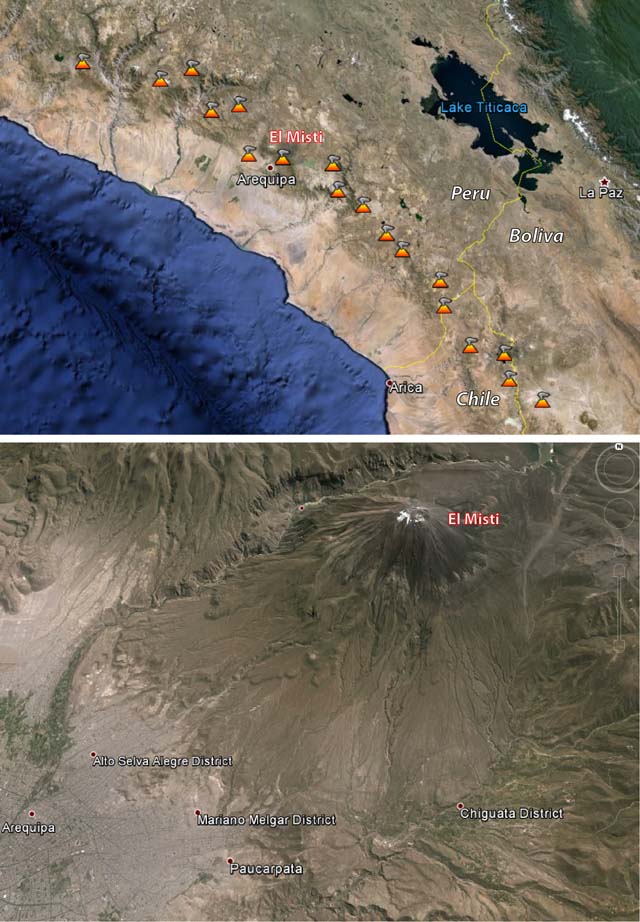 |
Figure 1. These Google Earth images highlight the locations of El Misti and major surrounding landmarks. Courtesy of Google Earth. |
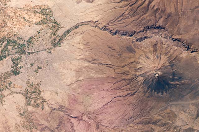 |
Figure 2. A mosaic of two astronaut photographs of Misti and the nearby town of Arequipa, Peru, taken on 16 October 2009. The city center of Arequipa is only 17 km SW of Misti's summit. According to NASA, the urban area is bordered by green agricultural fields in the image. The channel in the image NW of the volcano is the Chili River. Arequipa is the second most populous city in Peru, with about one million residents. Courtesy of NASA. |
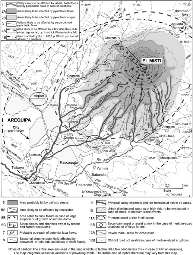 |
Figure 3. Hazard-zone map for El Misti based on the VEI 4 Plinian eruption that took place about 2030 years ago. Note that the entire city of Arequipa is vulnerable to pyroclastic surges, and areas closest to the volcano would be at high risk even for small- and medium-sized events. Courtesy of Cobeñasa and others (2012). |
According to Thouret and others (2001), the maximum fumarole temperature at the lava plug, measured in December 1997, was 220°C.
The Geophysical Institute of Peru (IGP) reports on its website that Misti has been monitored daily in real time since 2005 through a network of five seismic stations. Earthquake data for the most recent one-week period is displayed on its website. For example, between 29 April and 5 May 2013, Misti experienced 21 long-period (LP) earthquakes and 163 volcanic-tectonic (VT) earthquakes; between 8-14 July 2013, the volcano experienced 28 LP earthquakes and 104 VT earthquakes.
A news account (El Comercio) on 28 August 2012 said the IGP had detected a small seismic swarm during the previous week, the first such swarm in more than five years. During that week, 224 total earthquakes were recorded, 143 of which were VT.
References. Cobeñasa, G., Thouret, J., Bonadonnab, C., and , Boivina, P., 2012, The c.2030 yr BP Plinian eruption of El Misti volcano, Peru: Eruption dynamics and hazard implications: Journal of Volcanology and Geothermal Research, v. 241-242, p. 105-120.
Thouret, J., Finizola, A., Fornari, M., Legeley-Padovani, A., Suni, J., Frechen, M., 2001, Geology of El Misti volcano near the city of Arequipa, Peru: Geological Society of America Bulletin, v. 113, iss. 12, p. 1593-1610.
Geological Summary. El Misti is a symmetrical andesitic stratovolcano with nested summit craters immediately NE of the city of Arequipa, Peru. Eruptions from the active cone began about 13,700 and 11,300 years ago, within a 1.5 x 2 km caldera that underwent collapse about 50,000 years ago. A large scoria cone has grown with the 830-m-wide outer summit crater. At least 20 tephra-fall deposits and numerous pyroclastic-flow deposits have been documented during the past 50,000 years, including a pyroclastic flow that traveled 12 km S about 2,000 years ago. The most recent activity has been dominantly pyroclastic, and strong winds have formed a parabolic dune field of volcanic ash extending up to 20 km downwind. An eruption in the 15th century affected nearby Inca inhabitants. Some reported eruptions may represent increased fumarolic activity.
Information Contacts: Geophysical Institute of Peru (IGP) (URL: http://www.igp.gob.pe/); El Comercio (URL: http://elcomercio.pe/); and Inca Trail Reservations (URL: http://incatrailreservations.com/).