Report on Heard (Australia) — August 2013
Bulletin of the Global Volcanism Network, vol. 38, no. 8 (August 2013)
Managing Editor: Richard Wunderman.
Heard (Australia) Satellite thermal alerts continue to early October 2013
Please cite this report as:
Global Volcanism Program, 2013. Report on Heard (Australia) (Wunderman, R., ed.). Bulletin of the Global Volcanism Network, 38:8. Smithsonian Institution. https://doi.org/10.5479/si.GVP.BGVN201308-234010
Heard
Australia
53.106°S, 73.513°E; summit elev. 2745 m
All times are local (unless otherwise noted)
[A previous report (BGVN 38:01) provided] information from Matt Patrick of the Hawaiian Volcano Observatory (HVO) on the onset of thermal alerts measured by satellites for Heard Island (see map in BGVN 38:01) in September 2012 after a 4-year hiatus. MODIS/MODVOLC measured thermal alerts fairly regularly from 21 September 2012 through 6 October 2013, with the greatest number of days with measured thermal alerts in December 2012 and March 2013.
In a satellite image acquired by NASA Earth Observatory on 13 October 2012 (figure 19), Heard Island is covered in [clean snow and glacial ice, and Mawson Peak appears quiet....] By 7 April 2013 Mawson's steep-walled summit crater had filled, and a trickle of lava had spilled down the volcano's SW flank (figure 20). On 20 April (figure 21), the lava flow remained visible, and had even widened slightly just below the summit.
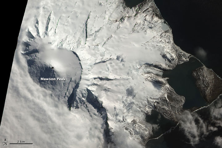 |
Figure 19. Although not definitive, this natural-color satellite image taken 13 October 2012 suggests an ongoing eruption. The dark summit crater (much darker than Mawson's shaded SW face) is at least partially snow-free. There is also a faint hint of an even darker area within, perhaps a lava flow. Shortwave infrared data shows hot surfaces within the crater, indicating the presence of lava in or just beneath the crater. Heavy cloud cover camouflaged what may have been a plume that erupted less than an hour after the image above was captured. Image and information courtesy of Robert Simmon, NASA Earth Observatory, using data from Advanced Land Imager (ALI) aboard the Earth Observing-1 (EO-1) satellite. |
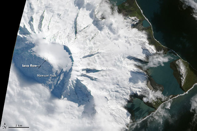 |
Figure 20. Natural-color satellite image of Heard Island acquired 7 April 2013 by the EO-1 ALI. Image courtesy of Jesse Allen and Robert Simmon, NASA Earth Observatory, using data from Advanced Land Imager (ALI) aboard the Earth Observing-1 (EO-1) satellite; information courtesy of Robert Simmon. |
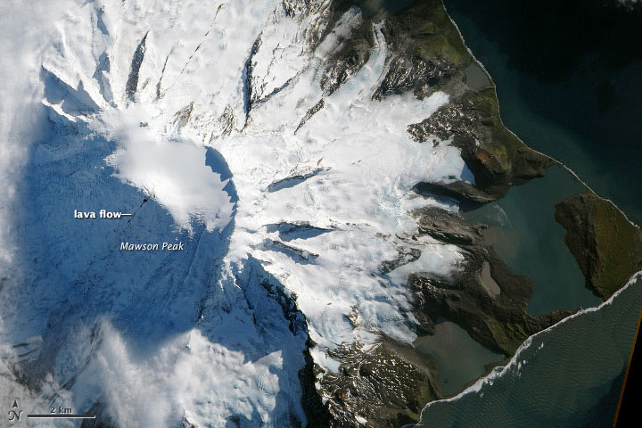 |
Figure 21. Satellite image of Heard Island acquired on 20 April 2013 by the Advanced Land Imager (ALI) aboard the Earth Observing-1 (EO-1) satellite. When compared with an image taken 7 April 2013 (figure 20), it appears that the lava flow is widening at the volcano's caldera; the caldera appears to have filled with so much lava that some has cascaded down Mawson Peak. Image courtesy of Jesse Allen and Robert Simmon, NASA Earth Observatory, using data from Advanced Land Imager (ALI) aboard the Earth Observing-1 (EO-1) satellite; information courtesy of Robert Simmon. |
Satellite inventory, 2000-2010. Patrick and Smellie (2013) recently published an article on a 10-year (2000-2010) spaceborne inventory of volcanic activity in Antarctica and southern oceans, including Heard Island. They noted that MODVOLC alerts indicated that eruptive activity at Heard Island comprised three sustained episodes during the decade; 24 May 2000-2 February 2001, 9 June 2003-June 2004, and 11 March 2006-2 March 2008. "Throughout the first two eruptions and their subsequent repose intervals, the summit vent was small, and less than 100 m wide... At some time in 2008 or early 2009 ... the summit crater widened to 200 m." Also, the authors noted that "the activity at Heard Island was entirely effusive and there is no evidence for any low-level explosive activity" during the study decade. The article notes that a limiting factor for satellite monitoring in this region is persistent cloud cover, although tall volcanoes such as Big Ben on Heard Island often have their summits above the cloud cover, resulting in "a higher rate of cloud-free views."
Reference. Patrick, M.R., and Smellie, J.L., 2013, Synthesis: A spaceborne inventory of volcanic activity in Antarctica and southern oceans, 2000-10, Antactic Science, v. 25, no. 4, p. 475-500, doi:10.1017/S0954102013000436.
Geological Summary. Heard Island on the Kerguelen Plateau in the southern Indian Ocean consists primarily of the emergent portion of two volcanic structures. The large glacier-covered composite basaltic-to-trachytic cone of Big Ben comprises most of the island, and the smaller Mt. Dixon lies at the NW tip of the island across a narrow isthmus. Little is known about the structure of Big Ben because of its extensive ice cover. The active Mawson Peak forms the island's high point and lies within a 5-6 km wide caldera breached to the SW side of Big Ben. Small satellitic scoria cones are mostly located on the northern coast. Several subglacial eruptions have been reported at this isolated volcano, but observations are infrequent and additional activity may have occurred.
Information Contacts: Matt Patrick, Hawaiian Volcano Observatory (HVO), U.S. Geological Survey, PO Box 51, Hawai'i National Park, HI 96718, USA (URL: https://volcanoes.usgs.gov/observatories/hvo/); NASA Earth Observatory (URL: http://earthobservatory.nasa.gov/); MODIS/MODVOLC, Hawai'i Institute of Geophysics and Planetology (HIGP), MODVOLC Thermal Alerts System, School of Ocean and Earth Science and Technology (SOEST), Univ. of Hawai'i, 2525 Correa Road, Honolulu, HI 96822, USA (URL: http://modis.higp.hawaii.edu/).