Report on Tolbachik (Russia) — August 2013
Bulletin of the Global Volcanism Network, vol. 38, no. 8 (August 2013)
Managing Editor: Richard Wunderman.
Tolbachik (Russia) Strombolian eruption during 2012-2013 produced lava flows 17-20 km long
Please cite this report as:
Global Volcanism Program, 2013. Report on Tolbachik (Russia) (Wunderman, R., ed.). Bulletin of the Global Volcanism Network, 38:8. Smithsonian Institution. https://doi.org/10.5479/si.GVP.BGVN201308-300240
Tolbachik
Russia
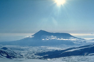
55.832°N, 160.326°E; summit elev. 3611 m
All times are local (unless otherwise noted)
In our last Bulletin report (BGVN 37:12), we noted that nearly 36 years after its last eruption, the largest basaltic eruption in Kamchatka during historic times, Tolbachik began erupting again on 27 November 2012. The eruption emerged at two fissures situated along the W side of Tolbachinsky Dol (a lava plateau along the SW flank of Plosky Tolbachik), in the same area as the northern vents of the 1975/76 eruptions. The 2012 eruption produced both low viscosity and effusive lava flows, and its explosions generated low-level ash-bearing plumes. The Aviation Color Code remained at Orange until 27 August 2013 when it was lowered to Yellow.
Edwards and others (2013) noted that at the vent on 25 January 2013, molten lava bombs shot more than 100 m above the crater floor. That reference also featured a mid-February 2013 photo showing a pahoehoe lava flow ~1 m thick. The authors stated evidence that the flow had advanced over the top of the snow.
Lavas emitted were voluminous, highly fluid, and extended as far as 17-20 km from the S fissure (figure 12). Satellite radar data mapped the lavas, which first traveled radially away from the highlands, going S. At lower elevations, flows branched and traveled W as a series of anastomosing flows (Edwards and others, 2013).
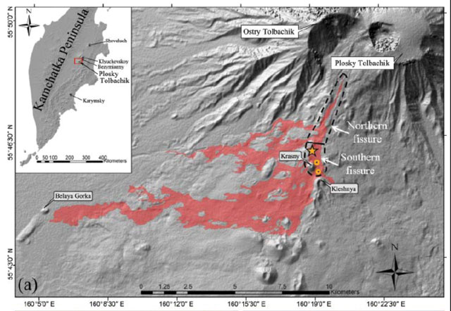 |
Figure 12. Map showing lava fields and the main vent (star) as of 15 February 2013. The lighting and shading effects show topography derived from a Shuttle Radar Topography Mission X-band digital elevation model (DEM; the technique applied here is called hillshade). Three older, preexisting cinder cones are shown as geographic reference points (Belaya Gorka, Kleshnya, and Krasny). Two areas where lava tubes are feeding surface flows are also indicated (orange circles with black centers). From Edwards and others (2013). |
According to Edwards and others (2013), observers on 29 November 2012 noted ash ejecting from two fractures as well as long, rapidly moving lava flows. Although the initial ash clouds reached 6 km in height, subsequent ashfall was limited to the area around the main vents. No permanent settlements were in danger from advancing lava flows since the closest settlements were about 40 km from the volcano.
According to Mayotte and others (2013), the new Tolbachik fissure eruption began with the effusion and explosion of aluminous, K- and Ti-rich trachy-basaltic andesites. Those andesites were black and sub-aphyric, with rare phenocrysts of plagioclase, olivine, and clinopyroxene. Microlites of the groundmass contained pilotaxitic and hyalopilitic structures with dovetail shapes. The petrography of the volcanic rocks of the first days of eruption attests to very rapid cooling, high rates of eruption, and high lava mobility.
On 19 December 2012, KVERT recognized that there were, by then, five cones with tops protruding above the fissure. In February 2013, four cones were reported. During mid-December 2012 to late August 2013, a very large thermal anomaly was reported on the N part of Tolbachinsky Dol. The thermal anomalies are congruent with the lava flows as well as the kind of venting behavior documented in figure 13.
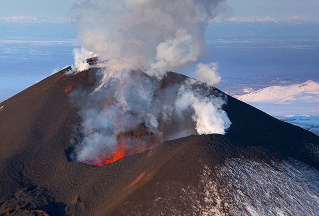 |
Figure 13. This helicopter view of the S slope of Tolbachik was taken 2 February 2013 by Denis Budkov. |
Tolbachik continued to produce lava flows during 4-15 January 2013 that traveled to the W and SE sides of Tolbachinsky Dol. Ash plumes rose to an altitude of 4.5 km and drifted in multiple directions. During 11-18 January, ash plumes rose to an altitude of 4 km and drifted in multiple directions. Between 25 January and 1 February 2013, four cinder cones continued to grow on the S fissure above Krasny cone. Ash plumes rose to an altitude of 3.5 km and drifted in multiple directions. Later, between 12 and 26 April, lava flows extended to the W, S, and E sides of the plateau. Cinder cones continued to grow along the S fissure through 16-22 August 2013. Gas-and-ash plumes rose to an altitude of 3 km and drifted in multiple directions.
The following week, the plumes weakened and remained so through August 2013. Seismic activity decreased during 22-24 August. Local video images around that time lacked incandescence from the N part of Tolbachinsky Dol, although a thermal anomaly continued to be detected in satellite images. On 27 August the Aviation Color Code was lowered to Yellow.
Overview of Eruption Activity from Edwards and others (2013). "Unlike the 1975 eruption, which was predicted 1 week in advance based on strong precursory seismicity at five seismic stations, the eruption that began in November 2012 was preceded by much weaker seismicity, so scientists were not able to predict this eruption. Earthquake hypocenters registered from more than 10 local seismometers were generally at depths of less than 10 kilometers and were mostly located below Plosky Tolbachik before earthquake activity migrated south to the eruption site . . .. Initial activity produced two primary fissures: a northern one, with four different active vents, and a southern fissure . . .. By the second day of the eruption, lava flows extended 9 kilometers from vent areas down into surrounding forests (Samoylenko et al., 2012). As of February 2013, weak explosive and effusive activity was ongoing at the main cone, and lava flows were active throughout the lava flow field from the southern fissure to Belaya Gorka, an older cinder cone 12 kilometers from the main vent (figure 12a).
"Effusive and explosive activities have continued since the start of the eruption (figures 12c and 12d). Ash from the initial explosive activity was deposited up to 60 km west of the main vent area, and initial sulfur dioxide (SO2) gas emissions are estimated to have been approximately 60 metric tons. By late January, ash production was minor and the continuous explosions from the main cone had weakened. The highest lava flow rates at the surface (approximately 1 m per second) were near lava tube openings in the upper part of the lava field (figure 1a). The eruption is now [in early 2013] dominantly producing pahoehoe (smooth), slabby pahoehoe, and `a`a (rough) lava flows. Minor phreatomagmatic explosions were seen at the leading edges of lava flows advancing over snow during the first week of the eruption [Samoylenko et al., 2012]. During January and February, active `a`a flows were observed moving over snow in the lower part of the flow field, and reports documented heated meltwater discharge and active downslope flows. Lava- snow interaction continued as snow accumulated through the winter . . .."
Preliminary Petrology from Edwards and others (2013). "Lava and tephra from the start of the eruption have isolated large crystals of plagioclase with smaller crystals of olivine and clinopyroxene. Preliminary geochemistry shows that samples are basaltic trachyandesite, with higher concentrations of silicon dioxide (52-54 weight percent) than in the basalts that erupted in 1975-1976 (48-50 weight percent). Field measurements using thermocouples and infrared radiometers show that the surface temperatures of active lava streams seen in figure 1d are more than 1000°C."
Comparison to the "Great Tolbachik" Eruption of 1975-1976 from Edwards and others (2013). "The new eruption shows striking differences compared to the 1975-1976 event. The seismicity at eruption onset was of lower magnitude and was confined to the crust (25 kilometers). In its first 2 months, the present eruption has already produced more than 20% of the bulk volume of the 1975-1976 eruption, which lasted 18 months. Estimated lava discharge rates during early parts of the ongoing eruption were up to 400 cubic meters per second...."
References. Edwards, B., Belousov, A..,Belousava, M., Volynets, A., Melniknov, D., Chirkov, S., Senyukov, S., Gordeev, E., Muraviev, Y.,Izbekov, P., and Demianchuk, Y., 2013, Another "Great Tolbachik" Eruption? Eos, Vol. 94, No. 21, 21 May 2013, pp. 189-191.
Volynets, A.O., Melnikov. D, Yakushev, A., and Tolstykh, M., 2013, Petrology and geochemistry of the New Tolbachik Fissure Eruption volcanic rocks and their evolution during the first two weeks of eruption, IAVCEI 2013 Scientific Assembly - July 20-24, Kagoshima, Japan (2013).
Geological Summary. The massive Tolbachik volcano is located at the southern end of the Kliuchevskaya volcano group. The massif is composed of two overlapping, but morphologically distinct, volcanoes. The flat-topped Plosky Tolbachik shield volcano with its nested Holocene calderas up to 3 km in diameter is located east of the older and higher sharp-topped Ostry Tolbachik stratovolcano. The summit caldera at Plosky Tolbachik was formed in association with major lava effusion about 6,500 years ago and simultaneously with a major southward-directed sector collapse of Ostry Tolbachik. Long rift zones extending NE and SSW of the volcano have erupted voluminous basaltic lava flows during the Holocene, with activity during the past two thousand years being confined to the narrow axial zone of the rifts. The 1975-76 eruption originating from the SSW-flank fissure system and the summit was the largest historical basaltic eruption in Kamchatka.
Information Contacts: Kamchatkan Volcanic Eruption Response Team (KVERT), Institute of Volcanic Geology and Geochemistry, Piip Ave. 9, Petropavlovsk-Kamchatsky, 683006, Russia; and Denis Budkov, Photographer, Kamchatka, Russia (URL: http://ratbud.livejournal.com/).