Report on Alaid (Russia) — October 2013
Bulletin of the Global Volcanism Network, vol. 38, no. 10 (October 2013)
Managing Editor: Richard Wunderman.
Alaid (Russia) Minor ash plumes on 17 and 23 October and 8 November 2012
Please cite this report as:
Global Volcanism Program, 2013. Report on Alaid (Russia) (Wunderman, R., ed.). Bulletin of the Global Volcanism Network, 38:10. Smithsonian Institution. https://doi.org/10.5479/si.GVP.BGVN201310-290390
Alaid
Russia
50.861°N, 155.565°E; summit elev. 2285 m
All times are local (unless otherwise noted)
Our previous report noted weak seismicity from Alaid during November 2003, although seismologists determined it was not related to volcanic activity (BGVN 28:11). This report discusses activity from December 2003 to January 2014. Emissions were observed in May 2010 and October 2012, but ash was not detected in the plumes until 23 October 2012. The last thermal anomaly was detected in December 2012.
Alaid volcano is located on Atlasova island off the southern tip of Russia's Kamchatka peninsula and represents the northernmost Holocene volcano in the Kuril Islands (figures 2 and 3). Other names for the volcano and island include Araido, Atlasova, Oyakoba, and Uyakhuzhach (Ukviggen, 2013). Despite the islands small size, its summit (2,339 m elevation) is the highest in the Kuriles. The volcano also plays a large and colorful role in the region's folklore (Ukviggen, 2013; Svalova, 1999).
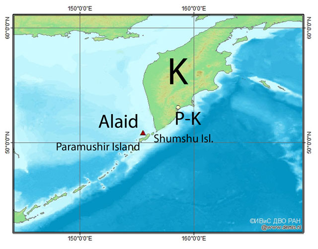 |
Figure 2. A regional map showing Alaid volcano, located S of the Kamchatka Peninsula (K), S of the city Petropavlovsk-Kamchatsky (P-K), and W of Paramushir and Shumshu Islands. Alaid (red triangle) is located at Atlasora Island. The original map was in Russian with authorship information at lower right. Courtesy of Kamchatka Volcanic Eruption Response Team (KVERT). |
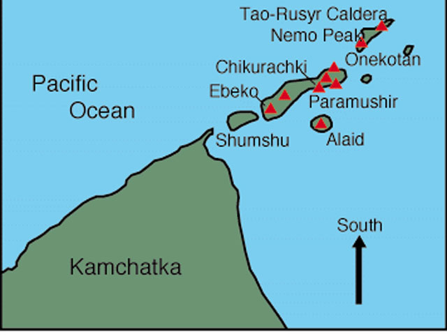 |
Figure 3. A simple map with S towards the top, illustrating Alaid on Atlasov island and some of the adjacent Holocene volcanoes in the Kuriles. Volcanoes on Kamchatka are omitted. Taken from Volcano World. |
On 5 October 2012, (KVERT) changed the Aviation Color Code from Green to Yellow due to "signs of elevated unrest above known background levels." A Volcano Observatory Notification to Aviation (VONA) noted that a possible explosive eruption could produce an ash column height of 10-15 km. Because Alaid is located near many flight routes, an eruption poses hazards to aviation (Girina and others, 2013).
On 23 May a gas-and-steam plume from Alaid was seen in satellite imagery drifting 11 km ESE. No other signs of possible increasing activity were seen in imagery or noted by observers on Paramushir Island during 21-28 May. During 2012, thermal anomalies were detected on 6, 12, 14-17, 19, 23, 27-28 and 30-31 October, 1, 4, 6-9, 12, 14, 20 and 24 November, and 4 and 12 December. At times, satellites could not detect thermal anomalies over Alaid volcano because of cloud cover, for example during the end of December 2012 and the beginning of January 2013. Visual observations from the adjacent Paramushir and Shumshu islands reported steam activity on 5, 11, 16, 17, 23, 26 and 27 October 2012; steam plumes rose 200 m on 5 October and 3 km on 23 October. (KVERT) and Institute of Volcanology and Seismology (IVS) FED RAS photographs showed fumarole activity on 6, 11, 12, 16, 25 and 27 October and 29 November 2012.
Several ash plumes erupting from Alaid volcano were reported in October and November 2012. (KVERT) and (IVS) FED RAS photographs from 17 and 23 October showed steam plumes containing ash rising 700 m. During this time, a small cinder cone grew in the larger summit crater. The volcano and its summit crater can be observed during an interval of inactivity on figure 4. Observers on 8 November 2012 noted that the volcanic cone was covered by ash.
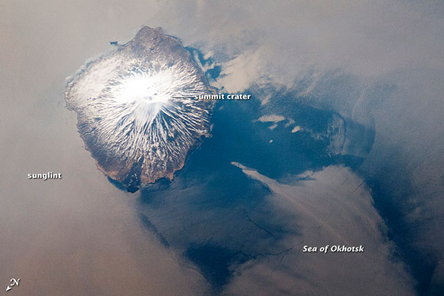 |
Figure 4. Photograph of Alaid during clear viewing conditions taken by the International Space Station's Expedition 31 crew on 18 May 2012. The silver-gray appearance on the sea surface surrounding much of the volcano results from strongly reflected sunlight bounced off the sea surface (sunglint). The image was provided by the ISS Crew Earth Observations experiment and Image Science & Analysis Laboratory, Johnson Space Center (Photo ID, ISS031-E-41959). Courtesy of the International Space Station, the Image Science & Analysis Laboratory at Johnson Space Center, and William L. Stefanov (Jacobs/ESCG at NASA-JSC). |
Because of mechanical problems, seismicity could not be monitored for the majority of the time Alaid was at Aviation Color Code Yellow; seismic data was unavailable from January 2009 until November 2012. The seismic station was repaired on 16 November 2012, and KVERT noted moderate seismic activity. During early December, the amplitude of volcanic tremor was in the range 12.1-18.7 μm/s. After 11 December 2012, technical reasons again prevented further seismic data acquisition.
On 8 January 2013 the Aviation Color Code was reduced to Green, meaning that "volcanic activity was considered to have ceased, and the volcano reverted to its normal, non-eruptive state" (KVERT).
References: Svalova, VB, 1999, Geothermal Legends through History in Russia and the Former USSR: A Bridge to the Past, Geothermal Resources Council Transactions, v. 22 p.235-239. PDF file. (URL: http://pubs.geothermal-library.org/lib/grc/1015911.pdf)
Ukviggen, 2013, Alaid: Part 1–the Banished Beauty, Volcano Cafe, 24 April 2013. Accessed online 13 January 2014. (URL: http://volcanocafe.wordpress.com/2013/04/24/alaid-part-1-the-banished-beauty/)
Girina,O., Manevich, A., Melnikov, D., Nuzhdaev,A., Demyanchuk, Y., and Petrova, E., 2013, Explosive Eruptions of Kamchatkan Volcanoes in 2012 and Danger to Aviation, EGU General Assembly, (abstract), 2013 meeting in Vienna, Austria. (URL: http://adsabs.harvard.edu/abs/2013EGUGA..15.6760G).
Geological Summary. The highest and northernmost volcano of the Kuril Islands, Alaid is a symmetrical stratovolcano when viewed from the north, but has a 1.5-km-wide summit crater that is breached open to the south. This basaltic to basaltic andesite volcano is the northernmost of a chain constructed west of the main Kuril archipelago. Numerous pyroclastic cones are present the lower flanks, particularly on the NW and SE sides, including an offshore cone formed during the 1933-34 eruption. Strong explosive eruptions have occurred from the summit crater beginning in the 18th century. Reports of eruptions in 1770, 1789, 1821, 1829, 1843, 1848, and 1858 were considered incorrect by Gorshkov (1970). Explosive eruptions in 1790 and 1981 were among the largest reported in the Kuril Islands.
Information Contacts: Olga Girina, Kamchatka Volcanic Eruptions Response Team (KVERT), a cooperative program of the Institute of Volcanic Geology and Geochemistry, Far East Division, Russian Academy of Sciences, Piip Ave. 9, Petropavlovsk-Kamchatsky, 683006, Russia; Volcano World (URL: http://volcano.oregonstate.edu/alaid); and International Space Station, the Image Science & Analysis Laboratory at Nasa's Johnson Space Center, and William L. Stefanov (Jacobs Technology).