Report on Planchon-Peteroa (Chile) — November 2013
Bulletin of the Global Volcanism Network, vol. 38, no. 11 (November 2013)
Managing Editor: Richard Wunderman.
Edited by Julie A. Herrick.
Planchon-Peteroa (Chile) February-June 2011 eruption; ashfall in local towns in May 2011
Please cite this report as:
Global Volcanism Program, 2013. Report on Planchon-Peteroa (Chile) (Herrick, J.A., and Wunderman, R., eds.). Bulletin of the Global Volcanism Network, 38:11. Smithsonian Institution. https://doi.org/10.5479/si.GVP.BGVN201311-357040
Planchon-Peteroa
Chile
35.223°S, 70.568°W; summit elev. 3977 m
All times are local (unless otherwise noted)
The last Bulletin report (BGVN 35:11) detailed an explosive eruption that began with gas-and-ash explosions in September 2010 and ended in mid-October 2010. Renewed activity began in February 2011 and continued through June 2011. In this report, we highlight the significant ash events from early-to-mid 2011 as well as the continuous monitoring efforts of Servicio Nacional de Geología y Minería (SERNAGEOMIN) during 2011-2013.
During 17 February-27 June 2011, unrest was detected from Planchón-Peteroa and significant meteorological information (SIGMET) notices were distributed by the Buenos Aires Volcanic Ash Advisory Center (VAAC) (table 3). Ash plumes were reported once or twice a month during this time period, although satellite images were not able to detect many of the events. Ash and gas plumes became continuous during late April, and ash plumes rose as high as 5.8 km altitude on 26 April. On 29 April, SERNAGEOMIN raised the Alert Level to 3 (Yellow).
Table 3. Emissions from Planchón-Peteroa during 18 February-27 June 2011. The Observatorio Volcanológico de los Andes del Sur (OVDAS) maintained a web-camera that contributed to numerous direct observations of emissions and is frequently listed as a source. Courtesy of Buenos Aires VAAC.
| Date | Altitude (km) | Drift Direction | Info Sources | Comments |
| 18 Feb 2011 | 4.3 | SE | SIGMET | No ash visible in satellite images. |
| 18 Mar 2011 | 4.3 | SE | SIGMET; ODVAS | Steam-and-gas plume visible from ODVAS web-camera. No ash visible in satellite images. |
| 26 Mar 2011 | -- | -- | SIGMET | No ash visible in satellite images. |
| 01-16 Apr 2011 | -- | -- | SERNAGEOMIN | White vapor plumes visible from the web-camera based in Romeral. |
| 17 Apr 2011 | 4.6 | NE | SIGMET | No ash visible in satellite images. |
| 18 Apr 2011 | 4.6 | NE | SIGMET | No ash visible in satellite images. |
| 26 Apr 2011 | 5.8 | E | SIGMET | No ash visible in satellite images. |
| 16-19, 21, 25-29 Apr 2011 | 4.2-6.4 | SW and NW | SIGMET; SERNAGEOMIN | Frequent ash plumes. Web-camera images captured plumes containing ash- to lapilli-sized particles during 17-19 and 29 Apr. |
| Alert Level 3 (Yellow) on 29 April 2011 | ||||
| 30 Apr 2011 | 4.2-6.4 | NW and N | SIGMET; SERNAGEOMIN | No ash visible in satellite images. |
| 01 May 2011 | 4-6.1 | NW | SIGMET | No ash visible in satellite images. |
| 02-03 May 2011 | 4.6-5.5 | NE and E | SIGMET; ODVAS | Ash-and-gas plumes. |
| 04-05 May 2011 | 4.3-7.3 | NW and ENE | SERNAGEOMIN; ODVAS | Overflight by SERNAGEOMIN on 4 May. No ash visible in satellite images. Ashfall was reported by proximal towns (see text). |
| 06 May 2011 | 4.6-5.5 | SE | GOES | A thin plume of ash, steam, and gas. |
| 07-10 May 2011 | 4.3-5.5 | SE | SERNAGEOMIN; ODVAS | Gas-and-ash plumes visible from ODVAS web-camera. No ash visible in satellite images. |
| Alert Level 2 (Green) on 13 June 2011 | ||||
| 24-25 Jun 2011 | 4.6 | W, NE, and E | SIGMET | No ash visible in satellite images. |
| 27 Jun 2011 | -- | NW | Buenos Aires VAAC | Gas-and-steam plumes possibly containing ash. |
Seismicity in April 2011 was dominated by volcano-tectonic (VT) events; 405 were detected, and locations were primarily concentrated in an area 25 km NE of the volcanic complex as well as along the N flank, ~6 km from the crater. Earthquakes were MC less than 2. Some tremor (RD of 3 cm2) and 30 long-period (LP) (RD 4 cm2) events were also detected that month. SERNAGEOMIN frequently reported seismic data in terms of RD, which is the value calculated from reduced displacements.
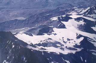
SERNAGEOMIN reported that ash emissions on 17, 18, and 29 April correlated with episodes of tremor with RD oscillating between 1 and 3 cm2. Overflights conducted on 26, 27, and 29 April determined that the active crater had not changed geometry and also appeared structurally stable (figure 7). The observers noted that tephra deposits from the previous explosions were notable SE and SW of the volcano. Deposits from the 29 April explosion were particularly easy to define during the overflight.
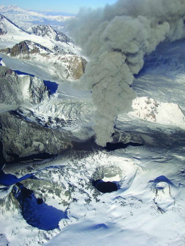 |
Figure 7. This photo of Planchón-Peteroa was taken during one of a series of overflights during 26, 27, and 29 April 2011. A column of ash rose from the active crater and tephra had visibly covered much of the snow immediately SE and SW of the crater. Courtesy of Orlando Rivera, Exploraciones Mineras Andinas S.A. |
Buenos Aires VAAC reported a significant ash plume detected by satellite images on 2 May 2011. The plume drifted between 4.9 and 5.5 km altitude toward the NE at ~7.7 m/s. The OVDAS web-camera also captured images of the plume appearing diffuse and ~3.7 km wide. The VAAC noted that the plume rapidly dissipated during 1315-1845 local time. The following day, continuous emissions of ash, steam, and gas were reported by SIGMET and the VAAC, although satellite images were not able to detect any emissions. By 1000, the VAAC reported SIGMET data for a plume that rose to 4.6-5.5 km altitude, moving E. At 1500, satellite images captured a diffuse and ~15 km wide ash plume. The plume drifted E at 5 m/s and had risen to 5.5 km altitude.
Elevated activity during 4-5 May produced ashfall that reached the towns of Minera Río Teno (about 70 km NW) and Las Leñas (in Argentina, 45 km ENE). An overflight conducted by SERNAGEOMIN confirmed continued ash emissions and explosions that occurred approximately every 30 seconds. The explosive activity rarely produced plumes higher than 1,000 m above the crater. Gray ash deposits were visible downwind of the crater; the wind tended to disperse tephra widely and the observers noted that wind directions were frequently directed to the E, NE, NNE, NNE, and NW. During 30 April-8 May, SERNAGEOMIN noted that seismicity included tremor (RD of 2-3 cm2) and VT earthquakes (ML less than 1.8).
Geologists from SERNAGEOMIN conducted an overflight of Planchón-Peteroa on 13 June 2011. RedMaule interviewed the observers who were on the helicopter which included representatives of SERNAGEOMIN and Oficina Nacional de Emergencia del Ministerio del Interior y Seguridad Pública (OMENI) as well as the mayor of Maule, Chile. The observers noted that persistent degassing continued; a low-level white plume (less than 400 m high), associated with fumarolic activity, was visible rising from the active crater (figure 8). SERNAGEOMIN concluded from the overflight that Alert Level 3 (Yellow) could be reduced to Alert Level 2 (Green/Normal); Alert Level 3 had been in effect since 29 April 2011.
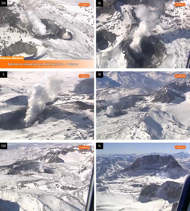 |
Figure 8. During an overflight of Planchón-Peteroa on 13 June 2011, few bare rocks were visible around the active crater due to snow-cover and ice; a low-level plume of white vapor rose from the crater. These six photos are stillshots taken from a video interview camera; note that the look direction varies in each photo with the approximate direction noted in the upper left corner of each photo. The tall peak of Planchón is visible in the background of the photo looking N. Courtesy of SERNAGEOMIN and RedMaule. |
The Buenos Aires VAAC released an ash advisory on 29 October 2011. Satellite images could not detect ash, but a SIGMET was available.
Activity during 2012. An approximate average of 400 earthquakes per month was detected in 2012, and roughly 75% of the events were VT while 25% were cataloged as LP events. The VT events were rarely larger than ML 3.0 and depths were in range of 4-10 km; these earthquakes were frequently clustered in groups that correlated with local faults. LP earthquakes were typically MD ≤ 2.0 and RD ≤ 2.9 cm2. SERNAGEOMIN reported tremor in April, May, November, and December (table 4). One notable seismic swarm occurred on 5 April. Approximately 123 VT earthquakes were detected during 0230-0730; these events were located ~20 km NE of the crater with depths less than 10 km. The largest earthquake was ML 1.7.
Table 4. Tremor was detected during four months in 2012. RD is the value calculated from the reduced displacements of seismicity. Courtesy of SERNAGEOMIN.
| Month | RD in cm2 |
| Apr 2012 | 1.1 |
| May 2012 | 1.1 |
| Nov 2012 | 0.6 |
| Dec 2012 | 0.3 |
On 30 October 2012, the Oficina Nacional de Emergencia del Ministerio del Interior y Seguridad Pública (OMENI) released a report highlighting several communities that would be included in the early warning system designed to report flood risks. The towns included Curicó, Romeral, and Teno, in the region Maule, which are especially vulnerable due to proximity to Planchón-Peteroa's major drainages (figure 9).
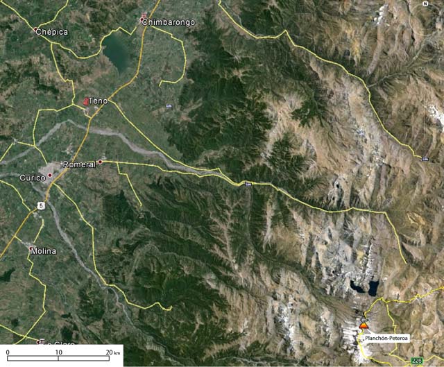 |
Figure 9. This Google Earth image includes the location of Planchón-Peteroa (lower right-hand corner), major towns, and primary roads. The background image is a composite of Landsat images from 2014. Note that the yellow line crossing through the volcanic center is the international border for Chile and Argentina. The scale is approximate. Courtesy of Google Earth. |
On 6 November 2012, the network of web-cameras captured images of a white plume rising from the crater. At 1620, the persistent plume rose to ~1.3 km and drifted NE. SERNAGEOMIN noted that this activity was related to fumarolic emissions.
Activity during 2013. During 2013, an approximate average of 200 earthquakes was detected per month. Of these events, ~80% were VT and ~20% were LP. Magnitudes and depths of the VT earthquakes were comparable to the previous year, although ML values were sparsely reported. LP seismicity was reported in ML, instead of MD and values were in range of 0.3 to 2.0. The reduced displacements (RD) of LP events were frequently reported on a monthly basis with values in range 0.3-8.4.
Tremor was rarely detected in 2013. SERNAGEOMIN reported six episodes of tremor, but these only occurred in January and the calculated RD was 0.5 cm2.
Geological Summary. Planchón-Peteroa is an elongated complex volcano along the Chile-Argentina border with several overlapping calderas. Activity began in the Pleistocene with construction of the basaltic andesite to dacitic Volcán Azufre, followed by formation of the basaltic and basaltic andesite Volcán Planchón, 6 km N. About 11,500 years ago much of Azufre and part of Planchón collapsed, forming the massive Río Teno debris avalanche, which traveled 95 km to reach Chile's Central Valley. Subsequently, Volcán Planchón II was formed. The youngest volcano, andesitic and basaltic andesite Volcán Peteroa, consists of scattered vents between Azufre and Planchón, and and contains a small steaming crater lake. Reported eruptions from the complex have been dominantly explosive, although lava flows were emplaced in 1837 and 1937.
Information Contacts: Observatorio Volcanológico de los Andes del Sur-Servicio Nacional de Geologia y Mineria (OVDAS-SERNAGEOMIN), Avda Sta María No. 0104, Santiago, Chile (URL: http://www.sernageomin.cl/); Buenos Aires Volcanic Ash Advisory Center (VAAC) (URL: http://www.smn.gov.ar/vaac/buenosaires/productos.php); and Oficina Nacional de Emergencia del Ministerio del Interior y Seguridad Pública (OMENI) (URL: http://www.onemi.cl/index.html).