Report on Kelud (Indonesia) — February 2014
Bulletin of the Global Volcanism Network, vol. 39, no. 2 (February 2014)
Managing Editor: Richard Wunderman.
Kelud (Indonesia) Eruption with plume top over 26 km altitude; ~7 deaths and over 100,000 refugees
Please cite this report as:
Global Volcanism Program, 2014. Report on Kelud (Indonesia) (Wunderman, R., ed.). Bulletin of the Global Volcanism Network, 39:2. Smithsonian Institution. https://doi.org/10.5479/si.GVP.BGVN201402-263280
Kelud
Indonesia
7.935°S, 112.314°E; summit elev. 1730 m
All times are local (unless otherwise noted)
On 13 February 2014, the Indonesian National Board for Disaster Management (Badan Nasional Penanggulangan Bencana-BNPB) reported that a major eruption occurred at Kelut (also known as Kelud) volcano in East Java, Indonesia. Ground-based observers had little insight about the ash plume height, but a number of satellite observations helped to constrain the height and other eruption parameters such the direction of plume movement. CALIPSO satellite data revealed that a rapidly rising portion of the plume ejected material up to an altitude exceeding ~26 km, well into the tropical stratosphere. Most of the less rapidly rising portions of the plume remained lower, at 19-20 km altitude. The 2014 eruption destroyed a dome emplaced in the volcano's caldera during the previous eruption in 2007 (BGVN 33:03 and 33:07). According to BNPB in a report issued on 18 February 2014, ~7 people were killed and ~100,000 evacuated. At least one commercial aircraft flew into the plume, later landing successfully but incurring costly engine damage.
This report discusses the pre- and syn-eruption observations from the early January through 25 February 2014. Much of the detailed reporting used here came from the Indonesian Centre for Volcanology and Geological Hazard Mitigation (CVGHM; also known as Pusat Vulkanologi dan Mitigasi Bencana Geologi, PVMBG). Kelut is located just S of Surabaya (Surabaja), Indonesia's second largest city (see figure 8 in BGVN 33:03).
Pre-eruption. According to CVGHM, the lake-water temperature in the crater increased 5.5°C during 10 September 2013 to 2 February 2014. During 1 January-2 February 2014 the number of shallow volcanic earthquakes at Kelut volcano increased. During 3-10 February 2014, seismic activity at Kelut was dominated by both shallow and deep volcanic earthquakes; some hypocenters were 3 km below the summit. Real-time Seismic-Amplitude Measurement (RSAM, a gauge of volcanic seismicity) values increased on 6 and 9 February 2014. Inflation was detected at one station.
Peaks of pre-eruptive seismicity occurred during 15-16 and 28 January, and 2-13 February. Table 3 also portrays the available early 2014 seismic data from CVGHM, but it can be hard to see the aforementioned detail because the various entries on table's rows generally summarize multiple days and some of the time intervals differ. The number of deep volcanic earthquakes fluctuated but generally increased overall. Earthquakes often occurred at 2-8 km depth. Based on these observations, on 2 February the Alert Level was raised to from 1 to 2 (on a scale with increasing severity in the range 1-4). Tiltmeter data on 10 February indicated inflation.
Table 3. Seismicity at Kelut volcano during January and into 13 February 2014. Note that the data stream changed abruptly on 13 February when four of Kelut's 5 seismic stations were destroyed by eruptive material. Courtesy of CVGHM.
| Time period 2014 (no. of days) | Shallow/deep volcanic earthquakes (VB / VA) | Deep/local tectonic earthquakes (TJ) (nr-none reported) | Low frequency earthquakes (LF) |
| 1-7 Jan (7) | 14 / 1 | 44 / -- | 4 |
| 8-14 Jan (7) | 18 / 4 | 32 / -- | 2 |
| 15-21 Jan (7) | 38 / 34 | 27 / -- | 0 |
| 22-31 Jan (10) | 234 / 74 | 79 / 2 | 1 |
| 1-3 Feb (3) | 111 / 30 | 3 / -- | 0 |
| 3-10 Feb (8) | 693 / 297 | 50 / -- | 0 |
| 13 Feb (1) | 440 / 1,135 | 1 / 3 | 198 |
Crater lake water temperatures continued to increase after September 2013, particularly during 23 January-9 February. Temperatures decreased slightly when measured on 10 February. On 10 February, based on the factors noted above, CVGHM increased the Alert Level to 3. This excluded visitors and residents from within a 5-km radius of the crater.
Eruption on 13 February. At 2115 on 13 February the Alert Level for Kelut was raised to 4, extending the exclusionary zone to a 10-km radius. As noted above, BNPB reported that a major eruption occurred less than two hours later at 2250, followed by another large explosion at 2330. NASA reported that satellite images showed the Kelut eruption about 2 hours later on 13 February 2014 at ~2315 local time (1615 UTC).
According to a Darwin VAAC (2014) weekly activity report, the eruption was seen on the hourly MTSAT-2 IR satellite for 1632 UTC (2332 local time) on 13 February, where it appeared as a rapidly expanding cloud. More details came from 10-minute IR data being used on a special basis in the High Ice Project in Darwin, which captured the eruption clearly as a small cluster of cold pixels on a 1610 UTC (2310 local time) IR image. Later analysis found a small low altitude plume as early as 1540 UTC (2240 local time) at Kelut on the MTSAT-1R satellite; this is the earliest reported start time for the eruption.
According to CVGHM, ash plumes rose to an altitude of 17 km and caused ashfall in areas NE, NW, W, and elsewhere as far as Pacitan (133 km WSW), Kulon Progo (236 km W), Temanggung (240 km WNW), and Banyuwangi (228 km E). As ash began to blanket parts of the region, 40 airline flights were cancelled; impacted airports included Juanda (81 km NE), Adi Sucipto Yogya (208 km W), and Adi Sumarmo Solo (175 km WNW). News articles reported that flights in and out of seven airports were cancelled or rerouted.
Figures 15 and 16 show satellite images of the plume taken on 13 February 2014. The image at the top of figure 15 portrays the scene at 0030 local time and the trace of the path across it taken by the satellite. At ~1813 UTC on 13 February. CALIPSO (Cloud-Aerosol Lidar and Infrared Pathfinder Satellite Observation). CALIPSO flew over the plume deploying CALIOP (a lidar instrument, essentially a laser range finder that creates a profile of clouds and particles in the atmosphere). This is one of the favored instruments for cloud height measurement. It is part of the A-Train, a constellation of multiple satellites and instruments that follow the same track on polar orbits and cross the equator within seconds to minutes of each other. This allows near-simultaneous observations. CALIOP data revealed that the Kelut ash cloud was generally at an altitude of 18-19 km, with some cloud/ash material reaching a maximum height of ~26 km. This is sufficiently high, and the A-Train data capabilities are sufficiently large to cause great interest, and more refined estimates of height and other parameters are likely to follow.
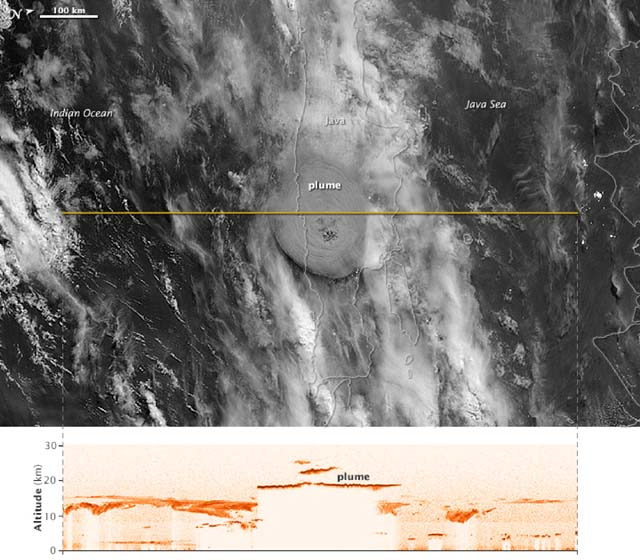 |
Figure 15. Figure 15 (top and bottom). At 0030 local time (1730 UTC 13 February) on 14 February, the Visible Infrared Imaging Radiometer Suite (VIIRS) on the Suomi NPP satellite acquired the top image as the gray circular ash plume over Kelut reached above a lighter-colored weather-cloud deck. Forty minutes later, at 0110 local time (1810 UTC 13 February), the Cloud-Aerosol Lidar and Infrared Pathfinder Satellite Observation (CALIPSO) satellite flew over the plume with its lidar instrument. The instrument recorded the ash cloud at nearly 20 km altitude, with sections of the plume reaching to nearly 26 km. Courtesy of NASA Earth Observatory; image by Jesse Allen, using data provided by the CALIPSO team; caption by Holli Riebeek. |
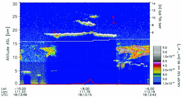 |
Figure 16. A cross-section through the Kelut volcanic plume from data acquired on 14 February 2014. The image zooms in on CALIPSO data for the tallest parts of the volcanic cloud (using the CALIOP data). The white line shows the approximate troposphere-stratosphere boundary. Some wave structure (small white oscillations) is apparent in the umbrella region. The vertical scale on the left shows computed altitude, and on the lower right shows the color scale for intensity of the 532 nm wavelength backscatter. The horizontal scale and labels at the bottom of the figure shows the latitude, longitude, and time in UTC for the vertical sounding across the transect. The red trace across the bottom of the figure shows land topography, with the volcano at the center. The AIRS (atmospheric infrared sounder) determined SO2 brightness temperature differences (BTD-scale at upper right) referring to features such as the red stars, where AIRS detected SO2 towards the edge of the cloud. Courtesy of Carn and Telling (2014). |
Figure 17 shows a view of an eruption at 0030 local time on 14 February. In Figure 18, a plane, service vehicle, and boarding area are shown covered by ash at Yogyakarta airport, 215 km E of Kelut. Closer to the volcano, ashfall and tephra blocks 5-8 cm in diameter caused structures to collapse, including schools, homes, and businesses.
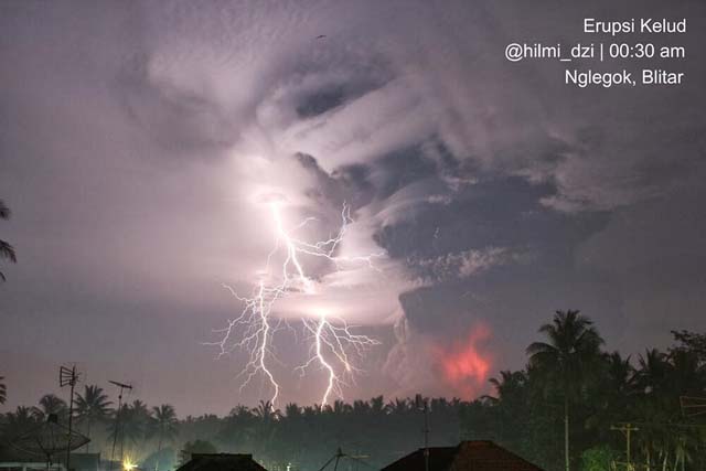 |
Figure 17. A photo of the eruption of Kelut at 0030 on 14 February 2014, with lightning being generated in the ash plume. Courtesy of Volcano Discovery web site (URL: http:pic.twitter.com/ypy7kx9615 / @hilmi_dzi). |
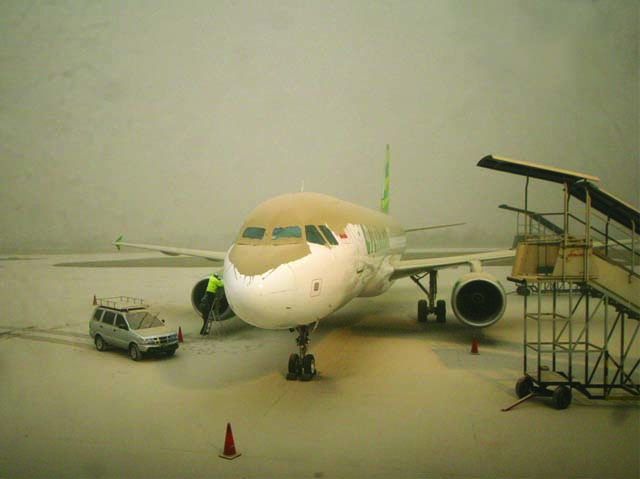 |
Figure 18. Image of a tan-colored ash blanket covering the landscape, including a parked jet liner and service vehicle, at Yogyakarta airport, 215 km W of Kelut, taken 14 February 2014. Image from NBC News web site (BIMO SATRIO / EPA). |
As a result of this eruption, four of the five Kelut seismic stations were destroyed, after which, volcanic and low-frequency earthquakes were not recorded. Subsequently, available seismicity recorded at the one remaining station, 5 km away, was dominated by continuous tremor with amplitudes ranging from 0.5 to 15 mm. That station later recorded declining seismicity during 14-20 February. Two more seismic stations were installed on 16 February, 2-3 km from the crater.
On 14 February, gray-to-black plumes rose 400-600 m above the crater, and on 15 February grayish white plumes rose as high as 3 km (figure 19).
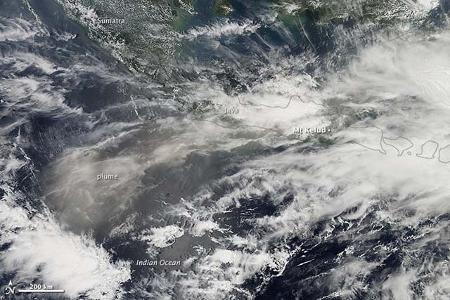 |
Figure 19. The eruption of Kelut (labeled just to the right of the image's center) on 13 February 2014 sent a large plume of ash drifting W across Java and over the Indian Ocean. This satellite image, acquired 14 February, shows widespread tan atmospheric discoloration from the ash plume. According to an advisory issued by the Australian Bureau of Meteorology, ash had reached 13 km in altitude, prompting the closure of several airports. Three people were killed, and Indonesian authorities have evacuated more than 75,000 people from their homes. NASA Earth Observatory, image by Jesse Allen and caption by Adam Voiland, using data from the Land Atmosphere Near real-time Capability for EOS (LANCE). |
On 14 February BNPB reported that the eruption had killed four people (but later estimates were higher): one died due to a collapsing wall, one from ash inhalation, and two from "shortness of breath." All four victims lived within 7 km of Kelut in the regency of Malang, an area that received ashfall up to 20 cm thick.
By 0600 on 14 February, BNPB reported that the number of displaced people reached 100,248, but the report also noted that volcanic activity had declined. Later that day BNPB noted that 76,388 people remained evacuated. Seismicity continued to decline and was at moderate levels during 15-17 February. During 16-20 February white plumes rose as high as 1 km and drifted N, NE, and E. Data from satellite instruments provided a 14 February 2014 image on sulfur dioxide (SO2) from Kelut (figure 20). The plume had spread primarily W of the volcano.
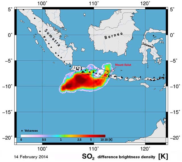 |
Figure 20. Sulfur dioxide burdens measured from Kelut (red triangle) over the Indonesian island of Java and Indian Ocean in the early morning of 14 February 2014 following the Kelut eruption. This image is based on data from the IASI instrument on the MetOp mission. Courtesy of European Space Agency (2014). |
Heavy rain on 18 February caused lahars in Ngobo, Mangli (Kediri, 35 km WNW), Bladak (Blitar, 20 km SW), and Konto (Malang, 35 km E). BNPB noted that the lahars flooded five houses and one mosque, and destroyed two homes and one bridge. An 18 February BNPB report noted that a total of 7 people in Malang regency had died, and that the ashfall had affected farms, including cattle health and dairy production, and the water supply. Damage to infrastructure in Malang included 3,782 houses, 20 government buildings, 251 schools, 9 hospitals, and 36 churches.
The Alert Level was lowered from 4 to 3 on 20 February and to 2 on 28 February based on decreased amplitude of tremors and thick clouds of white smoke continuously emitted from the crater instead of dark grey. At this point, visitors and residents were prohibited from approaching the crater within a radius of 5 km, but residents outside of this zone were permitted to return home.
Only a single pixel MODVOLC satellite thermal alert was measured during the interval from 13 February through March 2014. The alert occurred at 1515 hours UTC on 20 February 2014, the first alert measured since nearly daily alerts from Kelut's last eruption, 18 November 2007-23 January 2008. During the February 2014 eruption, cloudy weather over Kelut was a major factor that precluded some alerts from being measured, but those visualized suggest that the recent Kelut eruption continued until at least 20 February 2014.
A satellite image made available thanks to the International Charter Space and Major Disasters (2014) was acquired on 18 February and interpreted by the U.S. Geological Survey. The image reveals the impact of the eruption on the summit area and regions peripheral to it (figure 21).
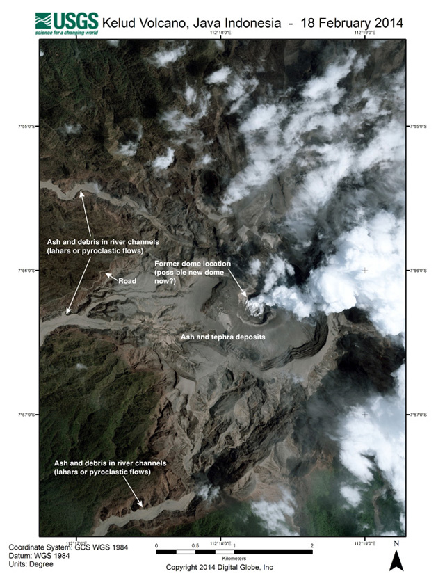 |
Figure 21. Satellite image of the crater area of Kelud, acquired on 18 February 2014. The former dome was destroyed during the 14 February eruption and significant ash and debris were deposited on the volcano slopes and in the river channels from lahars and pyroclastic flows around the volcano. Steam can be seen rising from the central crater. Courtesy of International Charter Space and Major Disasters (2014); source was WorldView, acquired 18/02/2014 by DigitalGlobe Inc.; map produced by USGS, and found online at Klemetti (2014c). |
Later visits disclosed that the 2014 eruption had left a large crater 400 m in diameter and destroyed the 2007 dome, parking area, and access stairs in the crater (see figures 22 and 23).
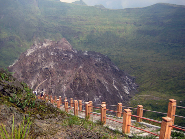 |
Figure 22. Photograph of the inner dome in Kelut volcano taken in 2010, showing the then- existing lava dome from the 2007 eruption and the access stairs to the crater, both of which were destroyed by the February 2014 eruption. Image courtesy of Zahidayat / Flickr, from Klemetti (2014b). |
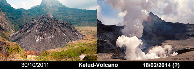 |
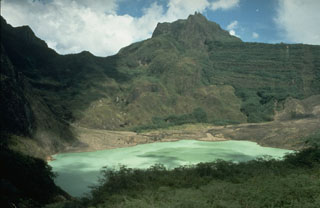
Figure 23. (Left) The Kelut lava dome that grew in the crater in 2007, photographed 30 October 2011 by Andersen (2011). In front of the dome was the small portion of what was left of the volcanic lake that used to fill the crater. (Right) The crater of Kelut seen on the morning of 18 February 2014 (photo by Suwarno, a local photographer, via Andersen), showing that the 2014 eruption forcefully removed the dome. Comparison figure came from Andersen (2014). |
A group of photographs taken by Oystein Lund Andersen (2014) during a visit from 22 to 23 February show after-eruption images, including steam rising from the crater area, ash and volcanic bombs deposited 2-5 km from Kelut's crater, and damage to trees and other vegetation by pyroclastic flows (for example, Figures 24 and 25). In addition, photographs showed that steam continued to rise from the crater through 25 February 2014. Andersen observed that activity at the volcano has decreased, but it was still unknown what exactly the situation at the vent is, whether or not a new lava dome is forming there.
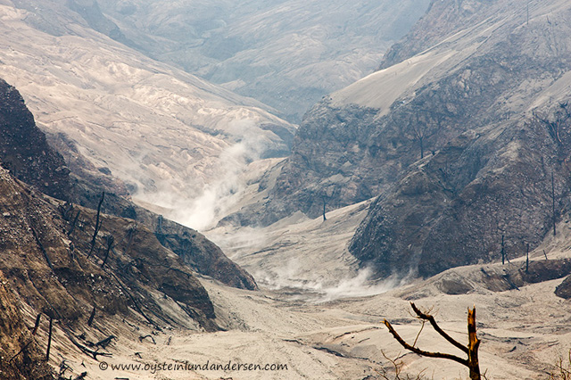 |
Figure 24. Steaming pyroclastic flow deposits in one of the valleys below the crater, a once forested area ~1 km SW of the crater. Photo taken at 1157 on 22 February 2014. Courtesy of Andersen (2014). |
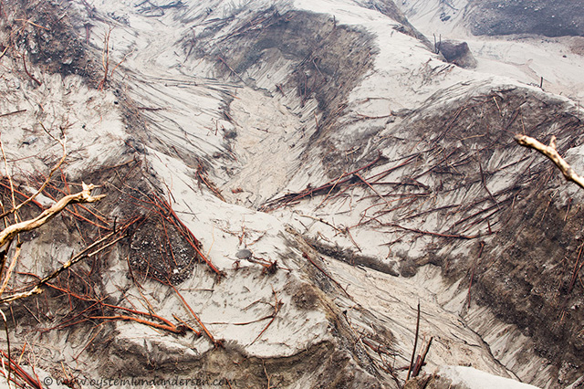 |
Figure 25. A lush green forest once stood here, now covered by deposits from a pyroclastic flow and scattered remains of large felled trees. Photo taken at 1205 on 22 February 2014. Courtesy of Andersen (2014). |
Airliner encounters plume. A commercial A320 airliner carrying passengers from Perth, Australia, to Jakarta, Indonesia, encountered an ash plume from Kelut near Indonesia on 14 February 2014. The incident was reported by the West Australian (Perth) newspaper and the Sydney Morning Herald (14 February). The reports noted that the airliner left Perth on 14 February 2014 at 0225 local time and flew through the ash cloud before arriving safely in Jakarta at 0550 local time. The estimated cost to replace the two engines of the Airbus aircraft was reported to be $20 million (US dollars). The A320 was grounded after the flight.
Morning Herald reporter Amanda Hoh (2014) reported that a "flight from Perth to Jakarta on Friday morning was filled with smoke after the plane flew into Indonesia's volcanic ash cloud…Richard Craig, from Perth, was on a flight to Jakarta at about 5am on Friday [14 February] when he said the plane suddenly flew into the ash cloud about 30 minutes before landing" Passenger Craig was quoted to have said "It was just starting to get light then it suddenly went quite dark and what I thought was smoke appeared in the cabin out the front, started coming out of the air vent and alarm went off and beeped a few times," he said. "There was an unusual smell. It wasn't like smoke, a slightly sweet smell. More like a very fine smoke…" The smoke cleared within a few minutes and Craig noted that the pilot announced that "it was a volcanic ash cloud and that 'no one was aware of it in the area.'" The plane landed safely.
Summary of damage. According to the International Federation of Red Cross and Red Crescent Societies (IFRC) (2014), "over the first few days the eruption affected 201,228 people (58,341 families) from 35 villages in three districts: Blitar, Kediri, and Malang... As of 14 February 2014, there had been seven fatalities and 70 people in hospitals in serious condition suffering from ash inhalation. Around this time the number of internally displaced persons (IDPs) had reduced to 100,248 people who had evacuated and camped across the province in 172 IDP camps set up to cater for their basic needs... In addition to the volcanic ash, heavy rain fell and produced cold lahar flooding in Malang, Kediri and Blitar districts. This caused further damage to buildings, farm lands, and roads."
Table 4 gives data on damage to structures in the 3 affected districts surrounding Kelut through February 2014. The figures are expected to increase once a more thorough assessment is made.
Table 4. An initial assessment of the damage to housing and other buildings as a result of Kelut eruption volcanic ash. Courtesy of IFRC (2014).
| District | Totally damaged | Moderately damaged | Minor damaged |
| Kediri | 8,622 | 5,426 | 5,088 |
| Malang | 1,514 | 1,066 | 1,378 |
| Bitar | 957 | 878 | 1,578 |
| Totals | 11,093 | 7,370 | 8,044 |
As reported on 24 February 2014 in the Jakarta Globe (Pitaloka, 2014), "torrential rain in East Java on 23 February 2014 prompted local officials to impose a safety curfew over some areas affected by the eruption of Mount Kelud for fear that rainwater could mix with volcanic dust, triggering mud flows." The Head of the Malang Disaster Mitigation Agency, Hafi Lutfi, said rain had triggered landslides that damaged several sections of mountain road. "A mud flow in Padansari village on Thursday [13 February] washed away two houses and two bridges, although no casualties were reported... Volcanic mud was carried down the mountain's slopes by the river, which flows through Kasembon, Ngantang and Pujon subdistricts" (figure 26).
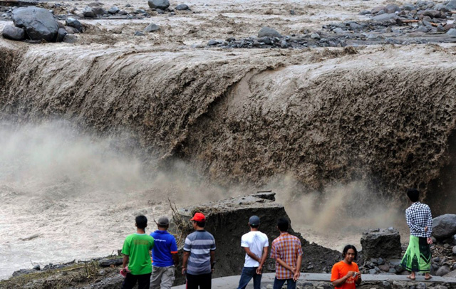 |
Figure 26. Villagers stand on the remains of a bridge washed out in Malang district near Pandansari village. The bridge succumbed to water mixed with volcanic material from Mount Kelut's eruption on 19 February 2014. From Pitaloka (2014); EPA photo by Fully Handoko. |
Lutfi was reported to have stated further that the "impact of Mount Kelud's eruption will extend far beyond the initial cleanup efforts. Fruit farmers reportedly lost more than Rp 24 billion ($2 million) in revenue as ash and debris destroyed whole fields of apples, durian and rambutan that were ready for harvest. The trees, covered in a thick coating of ash, had withered from lack of sunlight."
Background. The CVGHM reported that activity at Kelut last occurred in 2007, beginning with an increase in seismic activity and an eruption in October 2007. The activity ended with an effusive eruption on 3-4 November 2007 resulting with a crater lake surrounding a central lava dome (BGVN 33:03, 33:07, and 37:03).
References. Andersen, O.L., 2014 (22 February), Kelud Volcano, East-Java, Indonesia (URL: http://www.oysteinlundandersen.com/Volcanoes/Kelud/Kelud-Volcano-Indonesia-February-2014.html)
Andersen, O.L., 2011 (30 October), Mt. Kelud Volcano, Indonesia, 30 October 2011(URL: http://www.oysteinlundandersen.com/Volcanoes/Kelud/Kelud-Volcano-Indonesia-October-2011.html).
Carn, S., and Telling, J., 2014, Kelut 2014, IAVCEI (International Association of Volcanology and Chemistry of the Earth's Interior) Remote Sensing Commission (RSC) (URL: https://sites.google.com/site/iavceirscweb/eruptions/kelut-2014)
CIMSS Satellite Blog, 2014 (13 February), Eruption of the Kelut volcano in Java, Indonesia (URL: http://cimss.ssec.wisc.edu/goes/blog/archives/14910 ).
European Space Agency (ESA), 2014 (14 February), Kelut volcano grounds air travel, ESA Observing the Earth web site (URL: http://www.esa.int/Our_Activities/Observing_the_Earth/Kelut_volcano_grounds_air_travel).
Hoh, A., 2014 (14 February), Volcano eruption cancels Bali, Phuket flights and closes Indonesian airports, The Sydney Morning Herald (URL: 14http://www.smh.com.au/travel/travel-incidents/volcano-eruption-cancels-bali-phuket-flights-and-closes-indonesian-airports-20140214-32qd8.html)
International Charter Space and Major Disasters, (2014), Mount Kelud volcanic eruption in Indonesia (URL: http://www.disasterscharter.org/web/charter/activation_details?p_r_p_1415474252_assetId=ACT-481)
International Federation of Red Cross and Red Crescent Societies, 2014 (3 March), Emergency plans of action (EPofA), Indonesia: Volcanic eruption - Mt. Kelud (URL: http://reliefweb.int/sites/reliefweb.int/files/resources/MDRID009dref.pdf).
Klemetti, E., 2014a (11 February), Indonesian Eruption Update for February 11, 2014: Kelut and Sinabung (URL: http://www.wired.com/wiredscience/2014/02/indonesias-kelut-placed-highest-alert/)
Klemetti, E., 2014b (13 February), Significant Eruption Started at Indonesia's Kelut (URL: http://www.wired.com/wiredscience/2014/02/significant-eruption-started-indonesias-kelut/).
Klemetti, E., 2014c (24 February), Kelud, Before and After the Eruption (URL: http://www.wired.com/wiredscience/2014/02/kelud-eruption/).
National Aeronautics and Space Administration (NASA) Goddard Space Flight Center, 2014 (13 February), Kelut (Kelud) Eruption- February 13, 2014 (URL: http://so2.gsfc.nasa.gov/pix/special/2014/kelut/Kelut_summary_Feb14_2014.html)
Pitaloka, D.A., 2014 (24 February), Torrential Rain Worsens Kelud Misery, Jakarta Globe (URL: http://www.thejakartaglobe.com/news/torrential-rain-worsens-kelud-misery).
Volcano Discovery, 2014 (2 March), Kelut volcano news (URL: http://www.volcanodiscovery.Kelut volcano news & eruption updates _ 27 Sep 2007 - 2 Mar 2014.htm).
Geological Summary. The relatively inconspicuous Kelud stratovolcano contains a summit crater lake that has been the source of some of Indonesia's most deadly eruptions. A cluster of summit lava domes cut by numerous craters has given the summit a very irregular profile. Satellitic cones and lava domes are also located low on the E, W, and SSW flanks. Eruptive activity has in general migrated in a clockwise direction around the summit vent complex. More than 30 eruptions have been recorded since 1000 CE. The ejection of water from the crater lake during the typically short but violent eruptions has created pyroclastic flows and lahars that have caused widespread fatalities and destruction. After more than 5,000 people were killed during an eruption in 1919, an engineering project to drain the crater lake lowered the surface by more than 50 m. The 1951 eruption deepened the crater by 70 m, leaving 50 million cubic meters of water after the damaged drainage tunnels were repaired. Following more than 200 deaths in the 1966 eruption, a new deeper tunnel was constructed, and the lake's volume before the 1990 eruption was only about 1 million cubic meters.
Information Contacts: Indonesian Centre for Volcanology and Geological Hazard Mitigation – CVGHM (also known as Pusat Vulkanologi dan Mitigasi Bencana Geologi (PVMBG)), Jalan Diponegoro 57, Bandung 40122, Indonesia (URL: http://www.vsi.esdm.go.id/); Darwin Volcanic Ash Advisory Centre (VAAC), Australian Bureau of Meteorology, Northern Territory Regional Office, PO Box 40050, Casuarina NT 0811, Australia (URL: http://www.bom.gov.au/info/vaac); MODVOLC, Hawai'i Institute of Geophysics and Planetology (HIGP) Thermal Alerts System, School of Ocean and Earth Science and Technology (SOEST), Univ. of Hawai'i, 2525 Correa Road, Honolulu, HI 96822, USA (URL: http://modis.higp.hawaii.edu/); Badan Nasional Penanggulangan Bencana (BNPB – Indonesian National Board for Disaster Management), Jl. Ir.H.Juanda No. 36 Jakarta Pusat, Indonesia (URL: http://www.bnpb.go.id); CIMSS (NOAA's Cooperative Institute for Meteorological Satellite Studies), University of Wisconsin – Madison's Space Science and Engineering Center (SSEC) (URL: http://cimss.ssec.wisc.edu/goes/blog/about); NOAA Satellite and Information Service, Automated OMI SO2 Alert System, High SO2 Concentration Areas (URL: http://satepsanone.nesdis.noaa.gov/pub/OMI/OMISO2/Alert/alert.html); National Aeronautics and Space Administration (NASA) Goddard Space Flight Center (URL: http://so2.gsfc.nasa.gov); European Space Agency (URL: http://www.esa.int); West Australian (Perth) news (URL: http://au.news.yahoo.com/a/21467336/); Sydney Morning Herald (URL: http://www.smh.com.au); Andersen, Oystein Lund (URL: http://www.oysteinlundandersen.com/); IAVCEI Remote Sensing Commission website (URL: https://sites.google.com/site/iavceirscweb/eruptions/kelut-2014); and Simon Carn, Department of Geological and Mining Engineering and Sciences, Michigan Technical University, Houghton, MI.