Report on Kusatsu-Shiranesan (Japan) — June 2014
Bulletin of the Global Volcanism Network, vol. 39, no. 6 (June 2014)
Managing Editor: Richard Wunderman.
Edited by Julie A. Herrick.
Kusatsu-Shiranesan (Japan) Seismicity, deformation, and hydrothermal emissions during 2013-2014
Please cite this report as:
Global Volcanism Program, 2014. Report on Kusatsu-Shiranesan (Japan) (Herrick, J.A., and Wunderman, R., eds.). Bulletin of the Global Volcanism Network, 39:6. Smithsonian Institution. https://doi.org/10.5479/si.GVP.BGVN201406-283120
Kusatsu-Shiranesan
Japan
36.618°N, 138.528°E; summit elev. 2165 m
All times are local (unless otherwise noted)
Although no eruption ensued, the Japan Meteorological Agency (JMA) reported that the Alert Level for Kusatsu-Shirane was increased on 3 June 2014 from Level 1 (Normal) to Level 2 (Near-crater warning). Concern rose owing to elevated seismicity including shallow earthquakes within a few kilometers of the surface, deformation, elevated temperatures, and more. Many of the anomalies centered at or near Yugama, the largest of the three crater lakes within the volcanic complex (figures 8 and 9). Snow melted associated with fumaroles adjacent Yugama. Yugama lake was the scene of discolored water and floating sulfur on at least two occasions during 2013-2014. Seismicity rose in March 2014; ground deformation, in April 2014; and ground temperatures, in May 2014. Volcanic tremor was absent during this reporting period of February 2013-July 2014.
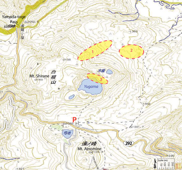 |
Figure 8. Annotated topographic map covering Kusatsu-Shirane and the surrounding area. Circled areas correspond to three fumarolic fields: 1, N-flank fumaroles (see figure 9); 2, NE-flank fumaroles (where typically the highest temperatures were measured from the three sites); and 3, the NNE shoreline of Yugama crater lake. Area 3 was also monitored by a web camera (maintained by Tokyo Institute of Technology). The Kusatsu-Shirane visitor center is located near the red letter P. Courtesy of JMA. |
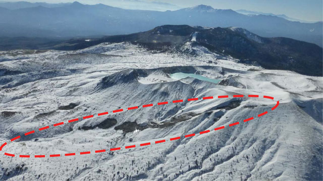 |
Figure 9. The N-flank fumarolic region (labeled 1 in figure 8) of Kusatsu-Shirane seen at 1058 on 5 December 2013 looking S. This is an aerial photo taken from ~2,440 m altitude. Snow had melted in some areas within the dashed red ellipse. The crater lake in the middle ground is Yugama. Courtesy of JMA. |
Activity during February-December 2013. JMA maintained Alert Level 1 through 2013 and fumarolic activity continued at a low level from the three zones (see figure 8). Temperatures measured with an infrared camera were typically less than 40°C. On 17 March 2013, JMA reported an increase in the number of small volcanic earthquakes with epicenters near the Yugama crater lake. Seismicity dropped back down to normal levels during April-September, and thermal activity continued at low levels.
JMA reported that seismicity was temporarily elevated in October 2013 in the area between Yugama crater lake and the Yamada-toge Pass (figure 10). Hypocentral depths were within 4 km of the surface, relatively shallow compared with previous months.
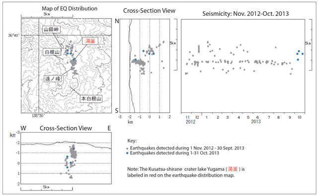 |
Figure 10. Map of earthquakes located during November 2012-October 2013. Earthquakes from October 2013 are highlighted in blue, indicating that seismicity was located between the crater lake named Yugama (labled with red symbols) and a pass named Yamada-toge (~2 km NW of Yugama crater lake). Earthquake depths were within 4 km of the surface. Courtesy of JMA. |
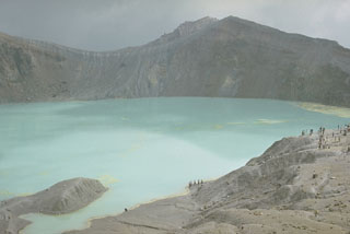
Aerial observations on 5 December 2013 determined that Yugama crater lake had two areas of cloudy water and, in one location, floating sulfur was visible on the lake surface. Figure 11 shows a photo of the lake with areas sketched in to show the approximate extent and location of where cloudy water and floating sulfur were found. Similar observations were made later, on 22 April 2014, when a cloudy area was noted during an overflight.
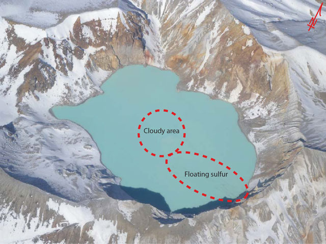 |
Figure 11. Locations of where discoloration was observed within Kusatsu-Shirane's crater lake, Yugama, are marked on this aerial photo taken on 5 December 2013. A cloudy area as well as sulfur debris was noted. Courtesy of JMA. |
Elevated seismicity during March-July 2014. During January-February 2014, up to 7 earthquakes occurred per day. An abrupt increase in seismicity was observed on 6 and 7 March 2014 when 10 and ~40 earthquakes per day respectively were recorded (figure 12). These earthquakes were centered within the area of Yugama. The note at the bottom explains the symbols refering to lake Yugama and Mount Ainomine to the lake's S. Earthquake depths were within 5 km of the surface and very clustered with few outliers (~2 earthquakes) located slightly deeper and further S. Seismicity subsided on 8 and 9 March, but during the following days, seismicity increased again and thereafter persisted for a few months. No other changes were detected from the area; diffuse white plumes continued to rise from the fumarolic zones.
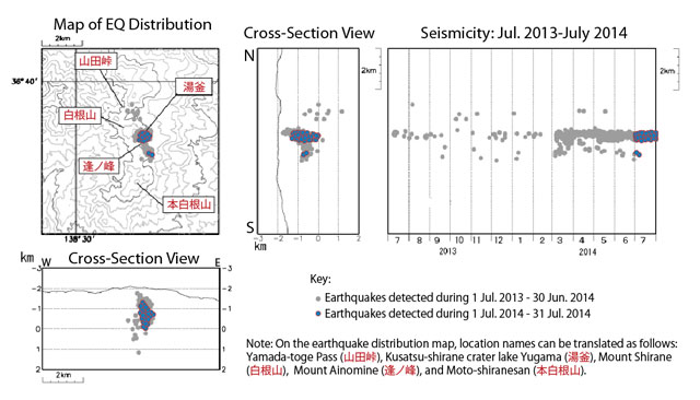 |
Figure 12. Map and cross sections showing seismicity at Kusatsu-Shirane during 1 July 2013 through 31 July 2014. Courtesy of JMA. |
Beginning in April, the GPS network registered an inflation trend across the Yugama crater region. Small-amplitude seismicity increased periodically during April-May. Ongoing magnetic surveys determined an increase in regional temperatures in May, but JMA cautioned that this characteristic was likely independent of the thermal emissions monitored at the fumarolic sites. Temperatures from the fumarolic sites had not changed significantly.
On 3 June, JMA raised the Alert Level from 1 to 2 (on a scale of 1-5) due to the ongoing seismicity, anomalous temperatures from magnetic surveys, and deformation. Gas emissions from the fumarolic sites, monitored by Tokyo Institute of Technology, changed in unspecified ways on 3 June. Warnings were announced for the immediate area of Yugama crater lake; the area within 1 km of the lake was potentially at risk if a small eruption occurred, particularly a gas explosion accompanied by ballistics. JMA recommended that no one enter the area and for any visitors to be mindful of gas hazards that could persist in low-lying areas (dense gases could collect within small valleys).
On 22 June, JMA reported the appearance of damaged vegetation; trees were dying in a forested area 3 km SW of Motoshiranesan cinder cone (location is the S-most labeled feature on the maps of figures 10 and 12). Note that Motoshiranesan is the highest peak belonging to the Kusatsu-Shirane complex (Hayakawa and others, 1981). An aerial survey was conducted on 23 June and observers noted that the affected area was ~10 m2. White vapor emissions with volcanic gas odors were noted and measurements from an infrared camera determined a maximum temperature of ~40°C. JMA reported that there was no apparent link between these changes and the ongoing seismicity.
In July, JMA maintained Alert Level 2 and reported that elevated seismicity continued, although tremor was not detected. More than 80 earthquakes were detected from the Yugama crater lake area on 24 and 31 July (figure 13). Fluctuations in deformation occurred and magnetic surveys indicated that regional temperatures were leveling off. Infrared camera data determined that no significant changes were occurring at the fumarolic sites. Gas emissions measured continued to suggest changes in the volcanic system.
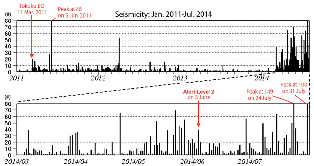 |
Figure 13. For Kusatsu-Shirane, the daily number of earthquakes recorded during July 2013-July 2014. Earthquakes increased abruptly in March 2014. Two months later, JMA raised the Alert Level from 1 to 2 due to persistent unrest (see text). Note that earthquake counts exceeded the y-axis on three occasions: 5 June 2011 (86 earthquakes), 24 July 2014 (149 earthquakes), and 31 July 2014 (100 earthquakes). Courtesy of JMA. |
Reference: Hayakawa, Y., Aramaki, S., Shimozuru, D., and Ossaka, J., 1981, Kusatsu-Shirane Volcano, in Aramaki, S., ed., Field Excursion Guide to Fuji, Asama, Kusatsu-Shirane, and Nantai Volcanoes: Volcanological Society of Japan, International Association of Volcanology and Chemistry of the Earth's Interior, p. 49-63.
Geological Summary. The Kusatsu-Shiranesan complex, located immediately north of Asama volcano, consists of a series of overlapping pyroclastic cones and three crater lakes. The andesitic-to-dacitic volcano was formed in three eruptive stages beginning in the early to mid-Pleistocene. The Pleistocene Oshi pyroclastic flow produced extensive welded tuffs and non-welded pumice that covers much of the E, S, and SW flanks. The latest eruptive stage began about 14,000 years ago. Historical eruptions have consisted of phreatic explosions from the acidic crater lakes or their margins. Fumaroles and hot springs that dot the flanks have strongly acidified many rivers draining from the volcano. The crater was the site of active sulfur mining for many years during the 19th and 20th centuries.
Information Contacts: Japan Meteorological Agency (JMA), Otemachi, 1 3 4, Chiyoda-ku Tokyo 100-8122, Japan (URL: http://www.jma.go.jp/).