Report on Suwanosejima (Japan) — November 2014
Bulletin of the Global Volcanism Network, vol. 39, no. 11 (November 2014)
Managing Editor: Richard Wunderman.
Suwanosejima (Japan) Periods with several eruptions per day during April 2013-December 2014
Please cite this report as:
Global Volcanism Program, 2014. Report on Suwanosejima (Japan) (Wunderman, R., ed.). Bulletin of the Global Volcanism Network, 39:11. Smithsonian Institution. https://doi.org/10.5479/si.GVP.BGVN201411-282030
Suwanosejima
Japan
29.638°N, 129.714°E; summit elev. 796 m
All times are local (unless otherwise noted)
This report covers activity at Suwanose-jima from 1 April 2013 to 31 December 2014. The previous Bulletin report (BGVN 38:04) detailed near-continuous tremor, a few earthquakes, and occasional ash plumes and eruptions during July 2012 through April 2013. This reporting period includes continuous tremor, intervals with several explosions per day, and plumes rising up to 5.5 km altitude. The data was gathered primarily from two key sources: the Tokyo Volcanic Ash Advisory Center (VAAC) and the Japan Meteorological Agency (JMA), who publishes monthly reports on Japanese volcanic activity (URL in Information contacts section).
The map in figure 17 highlights the location of the Otake crater, which was the source of the plumes, explosions, and other activity at Suwanose-jima during this reporting interval. The map was published by the JMA and also depicts the locations of monitoring sites for the volcano.
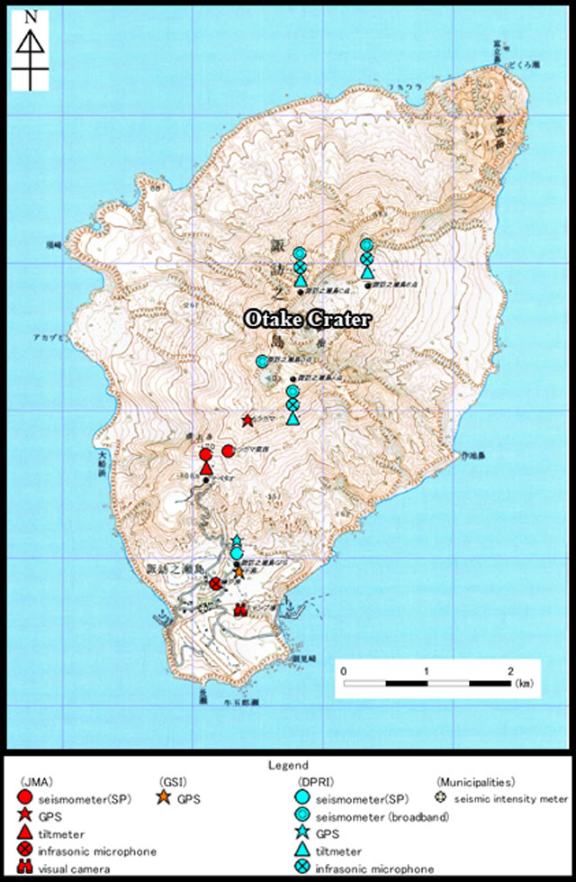 |
Figure 17. A map indicating monitoring sites and topography, with a contour interval of 20 m. The Otake crater is located in the center of the island. Seismometers (circles), infrasonic microphones (circles with crosses), tiltmeters (triangles), GPS (stars), and visual cameras (binoculars) were situated on the nearby slopes by several agencies. The Disaster Prevention Research Institute (DPRI) utilizes the light blue units, the JMA the red units, and the Geospatial Information Authority of Japan (GSI) the orange unit. Source: Iguchi and Ito (date unknown) with slight changes by Bulletin editors. |
Activity during 2013. According to the JMA (monthly reports), the Alert Level at Suwanose-jima constantly remained at 2 (on an increasing scale of 1-5). At night, high-sensitivity cameras regularly observed weak crater glow. A series of almost-continuous tremors began on 28 September 2012 and persisted through 2013.
During the month of April, the JMA noted that the tremor lasted for a total of 677 hours and 50 minutes. On 13 April 2013, the Otake crater had a minor eruption with plumes rising to 0.7 km above the crater.
The Otake crater did not erupt during May and June 2013. In May, white plumes generally rose to 0.2-0.3 km above the crater; the tallest plume reached 0.5 km. There was "no remarkable change in plume activity" in June, according to the JMA. During the month of May, a nearly continuous tremor lasted for a total duration of 704 hours and 54 minutes. It stopped on 1 June 2013 and then resumed on 12 June.
On 9 July 2013, a pilot reported an ash plume to 1.5 km altitude. However, the Tokyo VAAC was unable to detect ash in satellite images. Continuous tremor occurred from mid-June to 15 July and from 24 to 30 July. On 29 July, an earthquake occurred near Suwanose-jima, with a magnitude of 3.2 and a seismic intensity of 2 (an increasing scale of 0-7).
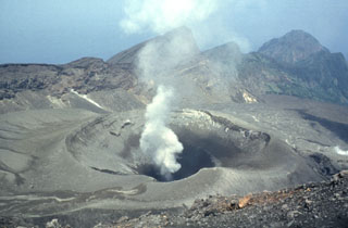
The International Association of Volcanology and Chemistry of the Earth's Interior (IAVCEI) conducted a field trip to the volcano during 15 and 18 July 2013 (figure 18). They found the volcano quiet, releasing only short, white plumes.
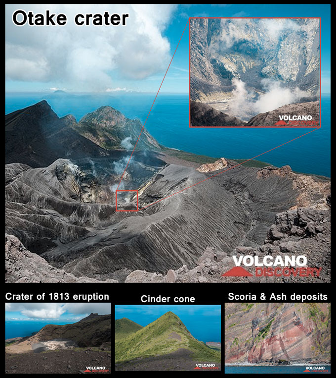 |
Figure 18. Photos taken from 16-18 July during a field trip associated with the IAVCEI 2013 Scientific Assembly. Additional photos can be found on Volcano Discovery. (Top) Otake crater, facing NE. A thin, white plume rises from the crater and is shown in greater detail in the zoomed photo on the upper right. (Bottom, left) Crater from which the 1813 subplinian Bunka eruption originated. (Bottom, middle) Flank of old cinder cone within the rift zone. The ground in this area was covered by spatter agglutinate from the 1813 eruption. (Bottom, right) Scoria and ash deposits in the NE cliff of the island. Source: Pfeiffer (2013), labeled by Bulletin editors. |
On 25 August 2013 at 1904 LT, the Otake crater erupted, and intermittent explosive eruptions continued from 26 August onwards. On 27 August, plumes rose to ~1.2 km altitude and drifted NE/SE. On 28 August, ash plumes beginning at 0910 LT rose to altitudes of 1.8-2.1 km, drifting NE and 3-3.7 km altitude, drifting E/NW. There was a total of 16 explosive eruptions during August. The above crater height of the resultant grayish white plumes generally ranged from 0.5-0.8 km, with the tallest plumes reaching ~1.5 km above the crater. Tremor occurred near continuously during 2-4, 11-14, and 25-31 August. Satellites utilized by the VAAC detected ash on 29 August, and from 30 August to 1 September, they detected explosions as well.
During September 2013, the Otake crater erupted explosively six times. Explosions occurred from 5-6 September with ash plumes rising to 1.8-2.1 km altitude, beginning at 0655 LT on the 5th and drifting NNW. On 12 September, ash plumes rose to 1.8 km altitude, drifting NW. During 29-30 September, ash plumes rose to 1.5 km altitude, drifting W and volcanic blocks were scattered around the crater on the 29th. Plumes in September generally rose above the crater to less than 1 km and the maximum height was 1.4 km. Earthquakes were felt near to Suwanose-jima on 10, 21, and 26 September 2013. The seismic intensity was 1 and tremor occurred intermittently.
During October, minor explosions occurred at the Otake crater during 13-15 and 21-22 October. Gray plumes from those eruptions generally rose above the crater to less than 0.6 km, with a maximum height of 1 km above the crater. Earthquakes were felt near the volcano on 9 October 2013. The seismic intensity was 2 and tremor occurred intermittently. On 21 October, an ash plume rose to 1.5 km altitude, heading S.
On 27 November 2013, the Otake crater erupted explosively 7 times, causing a scattering of volcanic projectiles around the crater. The eruption formed a plume that rose 1.8 km altitude, drifting E. In addition, Otake erupted occasionally throughout the month, with gray plumes above the crater generally rising to less than 0.6 km and a maximum plume height of 1 km. Tremor occurred intermittently.
Between 26 and 31 December 2013, Otake erupted 247 times, according to the JMA December 2013 report. From 27-28 December, plumes from Suwanose-jima rose to ~1.5 km altitude, drifting SE. On 28 December, small amounts of ashfall were observed [in the village ~4 km SSW] of Otake. According to the village administration, air shocks rattled windows and sliding doors from 28-29 December and crater glow was observable at night. On 29 December 2013, 125 explosions occurred, along with tremor and airshocks from about 0000 to 0300 LT. This indicated "consecutive eruptions," according to the JMA, with gray plumes rising to 0.6 km above the crater. The eruption ejected volcanic projectiles around the crater.
Activity during 2014. Information for activity during May, July, and October 2014 was unavailable, with an absence of VAAC reports for these intervals. During January, the Otake crater exploded 23 times, with volcanic projectiles scattering around the crater. The Tokyo VAAC noted explosions during 1-3 and 6 January. Between 1 and 2 January, explosions formed plumes to 0.9-1.8 km altitude, drifting SE. The explosions were heard in [the] village until the 3rd. During 8 to 9 January, explosions generated plumes, which rose to 1.2 km altitude and drifted NE/SE. The VAAC noted an explosion on 24 January, generating a plume that rose to 1.8 km altitude. Minor ashfall was observed on 1, 6, and 23 January.
During February 2014, the Otake crater exploded 7 times (on 2, 12, 19, and 23-24 February), with plumes reaching a maximum height of 1.2 km above the crater. On 2 February, the explosion at 1638 LT formed an ash plume to 1.8-3 km altitude that blew SE/SSE. On 12 February, the generated plume rose to 1.2 km altitude and drifted SE, and on 14 February, a plume rose to an altitude of 1.8 km altitude. During 23 to 24 February, plumes rose to 1.8 km altitude and drifted E. Volcanic seismicity for February was high and tremor occurred occasionally.
On 1 March 2014, the Otake crater erupted explosively. All other eruptions during March were minor and sporadic in occurrence. Plumes rose to a maximum height of 0.8 km above the crater. The volcanic seismicity was high and tremor occurred occasionally.
On 29 April, the Otake crater erupted explosively twice and the resulting plumes rose to 1.2 km altitude, heading E. All other eruptions during April were once again minor and sporadic in occurrence. Plumes reached a maximum height of 0.8 km above the crater.
During June 2014, the Otake crater erupted several times, with explosions on 18 June at 2246 LT, on 19 June at 1734 LT with a plume heading E, and on 20 June at 0933 LT. VAAC satellite imagery did not indicate any ash within the plumes.
Between 28 August and 1 September, eruptions resulted in ash plumes rising to 1.8-2.7 km altitude and drifting S, SE, E, and NE. Several eruptions occurred during the first week of September, with ash plumes rising to 1.8-5.5 km altitude on 3 September beginning at 1109 LT, 5.5 km altitude on 4 September at 1833 LT, and 2.1 km altitude on 9 September at 2233 LT.
On 14 November 2014, the Tokyo VAAC reported an explosion, with a plume rising to 1.8 km altitude and drifting SE.
Explosions at Suwanose-jima on 7 December 2014 formed plumes rising to 1.5-1.8 km altitude, drifting E/SE. On 14 December, plumes rose to 1.8 km altitude. and drifted SE.
SO2 emissions. Morita and others (2013) conducted an analysis of SO2 emissions at Suwanose-jima between 20 January and 7 May 2013. Using a UV spectrometer, Ocean Optics USB2000+, they obtained 3 to 15 minute long scans from between 0800 and 1700 LT. The average daily SO2 emission rate was ~700 tons/day (t/d), and ranged between 300 and 1300 t/d. These emission numbers are comparable to those at Suwanose-jima between 1975 and 2006, when the SO2 fluctuated between 300 and 1,130 t/d (Mori and others, 2013). The researchers also found positive correlations between seismic amplitude and released puffs with associated increases in SO2 emissions.
References. Iguchi, M., Ito, K., date unknown, 97. Suwanosejima, Japan Meteorological Agency (URL: http://www.data.jma.go.jp/svd/vois/data/tokyo/STOCK/souran_eng/volcanoes/097_suwanosejima.pdf) [accessed in April 2015]
Mori, T., Shinohara, H., Kazahaya, K., Hirabayashi, J., Matsushima, T., Mori, T., Ohwada, M., Masanobu, O., Iino, H., Miyashita, M., 2013, Time-averaged SO2 fluxes of subduction-zone volcanoes: Example of a 32-year exhaustive survey for Japanese volcanoes, 16 August 2013, Journal of Geophysical Research: Atmospheres (URL: http://onlinelibrary.wiley.com/doi/10.1002/jgrd.50591/full)
Morita, M., Mori, T., Iguchi, M., Nishimura, T., 2013, Continuous monitoring of sulfur dioxide emission rate at Suwanosejima volcano, Japan, Fall 2013, American Geophysical Union (URL: http://adsabs.harvard.edu/abs/2013AGUFM.V43B2875M)
Pfeiffer, T., 2013, Excursion to Suwanose-jima volcano (Tokara Islands, Japan) - photos from the IAVCEI 2013 field trip A3, July 2013, Volcano Discovery (URL: http://www.volcanodiscovery.com/suwanosejima/photos/july2013/fieldtrip.html) [accessed in April 2015]
Geological Summary. The 8-km-long island of Suwanosejima in the northern Ryukyu Islands consists of an andesitic stratovolcano with two active summit craters. The summit is truncated by a large breached crater extending to the sea on the E flank that was formed by edifice collapse. One of Japan's most frequently active volcanoes, it was in a state of intermittent Strombolian activity from Otake, the NE summit crater, between 1949 and 1996, after which periods of inactivity lengthened. The largest recorded eruption took place in 1813-14, when thick scoria deposits covered residential areas, and the SW crater produced two lava flows that reached the western coast. At the end of the eruption the summit of Otake collapsed, forming a large debris avalanche and creating an open collapse scarp extending to the eastern coast. The island remained uninhabited for about 70 years after the 1813-1814 eruption. Lava flows reached the eastern coast of the island in 1884. Only about 50 people live on the island.
Information Contacts: Japan Meteorological Agency (JMA), Otemachi, 1-3-4, Chiyoda-ku Tokyo 100-8122, Japan (URL: http://www.jma.go.jp/jma/indexe.html; Monthly report URL: http://www.data.jma.go.jp/svd/vois/data/tokyo/eng/volcano_activity/monthly.htm); Tokyo Volcanic Ash Advisory Center (VAAC), Tokyo, Japan (URL: http://ds.data.jma.go.jp/svd/vaac/data/)