Report on Bagana (Papua New Guinea) — December 2014

Bulletin of the Global Volcanism Network, vol. 39, no. 12 (December 2014)
Managing Editor: Richard Wunderman.
Bagana (Papua New Guinea) August 2014 to mid-April 2015, numerous ash plumes emitted
Please cite this report as:
Global Volcanism Program, 2014. Report on Bagana (Papua New Guinea) (Wunderman, R., ed.). Bulletin of the Global Volcanism Network, 39:12. Smithsonian Institution. https://doi.org/10.5479/si.GVP.BGVN201412-255020
Bagana
Papua New Guinea
6.137°S, 155.196°E; summit elev. 1855 m
All times are local (unless otherwise noted)
Bagana is one of Melanesia's youngest and most active volcanoes; it is located on Bougainville Island, Papua New Guinea (figure 14). [This report includes] a short summary of activity... from January 2013 through July 2014 (partly described in BGVN 39:06) [with more details for] August 2014-April 2015. The information included in this report primarily was found in material published by the Darwin Volcanic Ash Advisory Center (VAAC). Rabaul Volcano Observatory (RVO) [reports described] activity from August 2014.... [Local time (UTC + 11 hours) is used] for cases and observations reported by observers on the ground (two cases, on 10 and 12 August 2014); [UTC is used in other cases]....
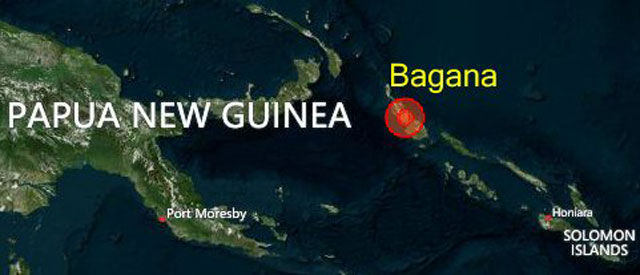 |
Figure 14. Image highlights the location of Bagana on Bougainville Island, Papua New Guinea. Bagana is located in a remote central portion of Bougainville Island. Papua New Guinea is located in SW Pacific, to the N and NE of Australia. Courtesy of the Darwin Volcanic Ash Advisory Center (VAAC). |
Activity during January 2013-July 2014. During this interval, Bagana's activity was mainly characterized by the emission of ash plumes. Based on information in Volcanic Ash Advisories (VAAs) published by the Darwin VAAC, in 2013 ash plumes from Bagana ranged from 1.8-4 km in altitude above sea level (a.s.l.) and drifted between 35 and 130 km. These plumes drifted towards the SW-N-E.
Through July 2014, ash plumes from Bagana ranged from 2.1-3 km in altitude a.s.l. and drifted 25-110 km according to the Darwin VAAC's VAAs. Ash plumes again drifted to the SW-N-E, and also to the SSE.
August-December 2014. This section documents activity at Bagana from August to December 2014. Information on Bagana's activity was scarce during October and December. From August through December, Bagana's Aviation Color Code (ACC) was mainly Orange; however, as noted below, on 12 August 2014, Bagana's ACC was upgraded to Red, the highest of the four colors in the Code. During this interval, ash plumes ranged from 2.1-7.6 km in altitude a.s.l. and drifted as much as 167 km. The plumes drifted to the SW-NE.
At the beginning of August 2014, variable amounts of thin to thick white vapor were seen being emitted from Bagana. During the second week of August, activity at Bagana increased. On 6 and 8 August, noises associated with rock falls were reported. According to the RVO, these rockfalls "may have been triggered by breakaway of large blocky lava from the front lobe of ongoing effusive lava flows which are [well known] for Bagana activity."
According to a 10 August 2014 RVO report, around 0500 local time on 10 August 2014, an eruption began at Bagana that emitted an ash plume with a height estimated at several hundred meters above the crater. Personnel at the government station at Piva in Torokina (figure 13, BGVN 39:06), reported that Bagana continued to emit variable thick dark ash clouds throughout the day. Ash clouds were blown to the SW and W, and possibly to the NW. In Wakovi, 6 km W of Bagana, ashfall was reported to have destroyed small tree branches, banana trees, and potato gardens. Ashfall was also reported in Laruma and at the Piva government station. RVO further stated, "Conditions at Gotana, located about 9 km southwest from the volcano, are slightly better and people from Wakovi have been urged to move there if ashfall continues and conditions deteriorates."
Whether any Wakovi residents did evacuate is uncertain.
From 2332 UTC on 10 August to 2132 UTC on 11 August, a volcanic ash plume was seen in satellite imagery (figure 15). The plume rose to an altitude of 3.1 km a.s.l. and eventually extended 167 km SW. On 12 August 2014, the Darwin VAAC observed ash clouds rising to an altitude of 7.6 km a.s.l., resulting in Bagana's ACC to be increased to Red. The plumes eventually extended 167 km SW. In their VAAs from 12 August UTC, the Darwin VAAC remarked that an ongoing eruption (described as low-level in VAAs from 0700-~1000 UTC) was observed on satellite. In some of those VAAs, they also stated, "Ash from [the] initial explosive eruption [was] partially obscured by thunderstorm activity and [was] becoming detached from [the] volcano."
According to a 13 August 2014 RVO report, at 1810 local time on 12 August, an earthquake was felt with an intensity of II on the Modified Mercalli Scale. The report stated that the earthquake was tectonic in origin. That RVO report also stated that areas in the W and SW were affected by ashfall. They described the level of exposure from ash as moderate in Wakovi and low around Kawai, Gotana and Piva government station (figure 13, BGVN 39:06).
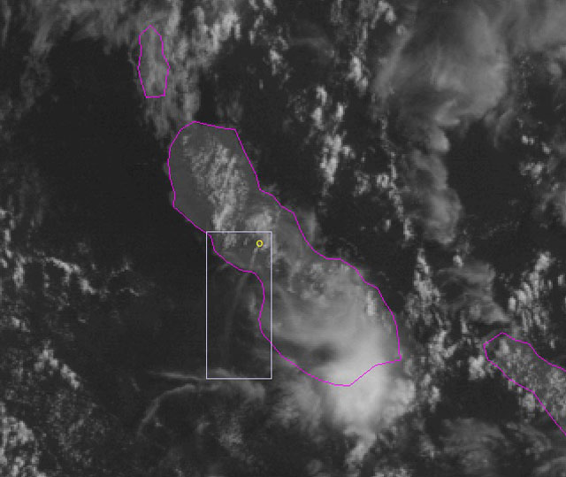 |
Figure 15. A MTSAT-2 Visible satellite image captured on 10 August at 23:32 UTC. Volcanic ash plume emitted from Bagana is enclosed in the white rectangle. This plume was observed to an altitude of 3.1 km a.s.l and eventually drifted 167 km SW. On the image, Bagana is represented by the yellow circle. Taken from 6-14 August 2014 Weekly Activity report compiled by the Darwin VAAC. |
According to the 13-19 August 2014 Darwin VAAC Weekly Activity report, Bagana's ACC was downgraded to Orange; the specific date when the downgrade occurred was not stated. Bagana's ACC remained Orange through the end of the year. RVO reported that since 10 August, there were ash emissions, but Bagana's level of activity had decreased.
From 25-28 August 2014, ash plumes, identified on satellite images, ranged from altitudes of 2.1-2.4 km a.s.l. and extended from 35-120 km, mainly to the W and WNW and some to the SW. From 19-31 August, RVO reported that Bagana's activity was characterized by weak to moderate white vapor. They reported light gray ash plumes blowing SW on 19 and 27 August and a dull glow emanating from the summit on 19, 27, 29, and 31 August. Low roaring noises were also briefly heard on 27 August according to the RVO.
During September 2014, the Darwin VAAC reported a narrow ash plume on satellite imagery at 2132 UTC on 13 September. The plume was observed at an altitude of 2.4 km a.s.l and extended 139 km to the W. Then at 2332 UTC on 20 September, another ash plume was observed at 2.4 km a.s.l. This plume extended 56 km W. In the available Darwin VAAC Weekly Activity reports, only Bagana's ACC was reported during the month of October.
In November 2014, an ash plume that extended 65 km S was observed at 2132 UTC on 8 November. In a VAA released at 0232 UTC on 9 November, the Darwin VAAC reported that ash from Bagana had dissipated in the satellite imagery. At the end of December 2014, Darwin VAAC reported an ash plume from Bagana on 29 December. The plume rose to an altitude of 2.4 km a.s.l. and extended ~95 km NE.
January through 14 April 2015. This section discusses Bagana activity from January to mid-April 2015. During this interval, Bagana's ACC was reported as Orange by the Darwin VAAC. During much of February and March 2015, Bagana's ACC was the only information reported in the available Darwin VAAC Weekly Activity reports. In this interval, ash plumes rose up to3.7 km in altitude a.s.l. and drifted to the N-NE-SE and to the SW.
At 2232 UTC on 20 January 2015, an ash plume was identified on satellite images. Darwin VAAC considered the plume to be low-level and it extended 37 km NE at an altitude of 3.7 km a.s.l. At 0032 UTC on 21 January, Darwin VAAC identified the ash plume again on satellite imagery. In that satellite image, the plume extended 22 km NE at an altitude of 3.7 km a.s.l. After that, the Darwin VAAC reported a meteorological cloud that covered the area. Later at 2232 UTC on 21 January, the plume was seen drifting 18 km SW at an altitude of 2.7 km a.s.l (figure 16).
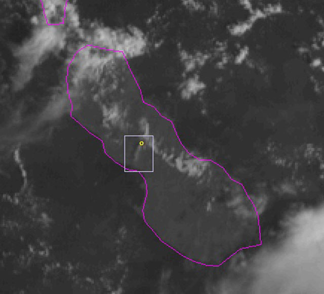 |
Figure 16. An MTSAT-2 satellite image captured at 2232 UTC 21 January 2015. The volcanic ash plume in within the rectangle drifted 18 km SW at an altitude of 2.7 km. Bagana is represented by the yellow circle. Taken from the 21-27 January 2015 issue of the Weekly Activity report compiled by the Darwin VAAC. |
On 25 March 2015, an ash plume was identified on satellite imagery at 2132 UTC. The plume was observed at 2.1 km and drifted 37 km N-NE. At 2132 UTC on 26 March, another volcanic plume was observed at 3.1 km and extended 56 km NE. The Darwin VAAC reported observing a consistent plume until 0108 UTC on 30 March, when ash had dissipated. When the consistent plume was first observed was not stated in the 25-31 March 2015 Darwin VAAC Weekly Activity report. Darwin VAAC also reported a plume on satellite images at 2132 UTC on 31 March. The plume drifted 74 km SE at an altitude of 2.1 km. The plume then shifted to the NE before a VAA at 0438 UTC on 2 April reported that the ash had dissipated. In the 8-14 April 2015 Weekly Activity report, the ACC remained at Orange.
Geological Summary. Bagana volcano, in a remote portion of central Bougainville Island, is frequently active. This massive symmetrical cone was largely constructed by an accumulation of viscous andesitic lava flows. The entire edifice could have been constructed in about 300 years at its present rate of lava production. Eruptive activity is characterized by non-explosive effusion of viscous lava that maintains a small lava dome in the summit crater, although occasional explosive activity produces pyroclastic flows. Lava flows with tongue-shaped lobes up to 50 m thick and prominent levees descend the flanks on all sides.
Information Contacts: Darwin Volcanic Ash Advisory Centre (VAAC), Bureau of Meteorology, Northern Territory Regional Office, PO Box 40050, Casuarina, NT 0811, Australia (URL: http://www.bom.gov.au/info/vaac/); and Rabaul Volcano Observatory, Department of Mineral Policy and Geohazards Management, Volcanological Observatory Geohazards Management Division, P.O. Box 386, Kokopo, East New Britain Province, Papua New Guinea.