Report on Hunga Tonga-Hunga Ha'apai (Tonga) — January 2015
Bulletin of the Global Volcanism Network, vol. 40, no. 1 (January 2015)
Managing Editor: Richard Wunderman.
Hunga Tonga-Hunga Ha'apai (Tonga) December 2014 to January 2015 eruption at submarine caldera builds new land above water
Please cite this report as:
Global Volcanism Program, 2015. Report on Hunga Tonga-Hunga Ha'apai (Tonga) (Wunderman, R., ed.). Bulletin of the Global Volcanism Network, 40:1. Smithsonian Institution. https://doi.org/10.5479/si.GVP.BGVN201501-243040
Hunga Tonga-Hunga Ha'apai
Tonga
20.5532°S, 175.3841°W; summit elev. 114 m
All times are local (unless otherwise noted)
A submarine eruption began here by 19 December 2014 and ended by 28 January 2015. Hunga Tonga and Hunga Ha'apai are small islands situated on the rim of a submarine caldera known by the names of the two islands (Hunga Tonga and Hunga Ha'apai) (figure 12). The 2014-2015 surtseyan eruption added a circular area of land over 100 m in elevation at a spot S of and about midway along Hunga Ha'apai island's length. The new island initially grew as an isolated third new island, but subsequently connected and joined with Hunga Ha'apai. The area of new land surface eventually reached about 1.5 to 2 km in diameter. The new island also grew to come as close a few hundred meters from Hunga Tonga island. The eruption issued dense ash plumes that generally rose less than about a kilometer in altitude but preliminary estimates on the associated higher, ash poor steam plumes rose to 7-10 km altitude.
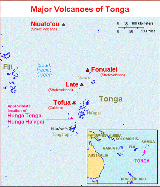 |
Figure 12.(Inset) A map showing a large scale view of the South Pacific with the Kingdom of Tonga highlighted in purple. (Main map) Hunga Tonga and Hunga Ha'apai lie on the rim of a submarine caldera located 65 km N of a wharf in the harbor at Nuku'alofa, Tongatapu island (the main island of the archipelago). Nuku'alofa is a deep-water port, the nation's capital, and Tonga's economic hub. Tongatapu island also hosts an international airport, which sits to the S of the capital. (The word "Ha'apai" is also used as the name of a region of islands and reefs well N of Hunga Tonga-Hunga Ha'apai.) The volcano also lies ~70 km SW of Normuka island. Courtesy of USGS. |
This 2014-2015 eruption followed 5 years of quiescence, the previous eruption having occurred in 2009 (BGVN 34:03). That 2009 eruption formed new land above water and deposits destroyed vegetation on neighboring Hunga Tonga and Hunga Ha'apai islands (BGVN 34:03). The 2009 eruption added land at the S end of Hunga Ha'apai island. New research has been published discussing the 2009 eruption since our earlier report (BGVN 34:03). For example, Allen and Riebeek (2009) issued a 28 March 2009 Earth Observatory picture of the day that featured Hunga Tonga-Hunga Ha'apai images depicting the island morphology before and after the eruption. For another example, Vaughan and Webley (2010) discussed satellite observations associated with the 2009 eruption. Bohnenstiehl and others (2013) also discussed marine acoustic signatures from the 2009 eruption.
A key source used to create this report on the 2014-2015 eruption consists of four reports created by the Tongan Ministry of Information and Communications (MIC) and released during 14-28 January 2015. Those four MIC Advisories (numbers 3, 4, 5, and 6) are hereafter referred to as MIC (2015 a, b, c, and d). MIC 3 (2015a) was issued 14 January looking back in time at key aspects of the eruption. Discussions included the location and behavior of the first seen early observations on 20 December 2014, a site visit by the Tongan Navy on 6 January, and a pilot report on 13 January 2015. MIC 4 (2015b) was issued on 19 January describing a visit made on 14 January. This was the first report of the existence of a new island. By this time the new island had attached to Hunga Ha'apai island, roughly doubling the size of that island. MIC 5 (2015c) was also issued on 19 January. It described observations made from a visit aboard a ship (the VOEA Neiafu) on 17 January. MIC 6 (2015b) issued on 28 January describing for a visit on 24 January 2015. The report noted a lack of ash, gas, or steam coming from the vent that formed the new island. The authors concluded that the eruption "appears to be over." They provided a sketch map of the new island.
There were no new MIC reports during February-March 2015. The visits and reporting drew on support that included the Tonga Meteorological Services, NZ-Meteorological Services, the Tongan Navy, National Emergency Management Office, Tonga Broadcasting Commission, the New Zealand High Commission, and Ministry of Lands and Natural Resources, Tonga Airport Limited, Tonga Meteorological Services, GNS-NZ, NZ-Meteorological Services, and possibly others.
Eruption, December 2014. The online newspaper Matangi Tonga on 30 December noted that fishermen observed an eruption near Hunga Tonga-Hunga Ha'apai on 19 December 2014 (Matangi Tonga, 2014). An editor from that publication, Mary Lyn Fonua, notified GVP of the eruption. The same publication issued over 10 reports during 30 December 2014 through at least 9 March 2015 (Matangi Tonga, 2014, 2015a, b, c).
MIC (2015a) was released at 0943 on 14 January; it reported the position of the vent that was active on 20 December. Figure 13 is a later version of their figure, made at higher resolution. MIC (2015a) described this particular area as venting steam and sulfurous-gas at the sea surface. Emissions here did not persist during the later stages of the eruption.
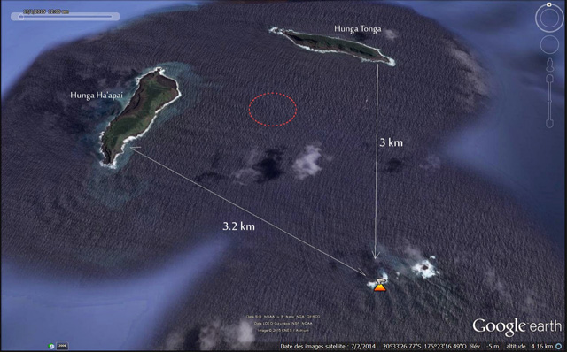 |
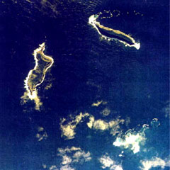
Figure 13. A map (N to top) showing the location of steaming at Hunga Tonga-Hunga Ha'apai volcano (orange icon) on 20 December 2014. Each of the two islands are about 2 km long and lie on margins or rim of the mostly submarine caldera, with Hunga Tonga island to the N, and Hunga Ha'apai island to the W of the caldera's center. The area circled in red is the approximate location of the vent that later formed a new rapidly growing island. Taken from Culture Volcan (2015). |
Klemetti (2014) showed an image from a MODIS instrument aboard the Aqua satellite that captured of the area of the eruption on 29 December 2014 (figure 14). A small white plume was in evidence at the volcano in the image. He commented that the area of discolored water stretching to the S could be due to the eruption.
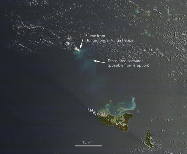 |
Figure 14. The eruption plume from Hunga Tonga-Hung Ha'apai seen on 29 December 2014 by Aqua's MODIS Imager. Image by NASA with annotations by Erik Klemetti (Klemetti, 2014). |
According to Metangi Tonga (2014) on 30 December 2014, "A continuing eruption from Tonga's active undersea volcano, Hunga Ha'apai, was clearly visible on the horizon northwest of Tongatapu today."
Activity during January 2015. During the 6 January visit (MIC, 2015a), observers nearing the volcano saw vigorous venting at a new location. MIC (2015a) did not disclose whether a new island had yet emerged but later reporting mentioned below did clearly document an island. The sea (or perhaps a very low island) discharged vigorous emissions of black ash and white billowing clouds. The new location was situated farther N, much closer to the preexisting islands, than the vent indicated in figure 13. That submarine vent to the S lacked further indications of steam emission during the course of the eruption. Neither of the preexisting islands appeared to contain active vents.
MIC (2015a) contained 11 captioned photos, but most are somewhat hazy and with limited contrast, conditions explained later (MIC, 2015b) as due to rain. Plumes on the 6th rose up to 2 km, but almost all the plumes in the photos were under 1.3 km altitude. At least one photo appeared to capture two low, vertical and parallel plumes. The photos documented some highly non-vertical black plumes, some peculiar low white plumes that seem to rise suddenly at distance, black plumes that appear to contain abundant clasts in their leading edge, low billowing clouds that encircle the darker ones and hug the water surface. In one case (figure 9 of MIC, 2015a) they reported that a white plume with its basal portion hugging the sea surface extended E over 3 km. The captions to their figures 10 and 11 indicated pulsing phenomena..
On 12 January 2015, Wellington VAAC reported ash from Hunga Tonga-Hunga Ha'apai reached an altitude of 6 km. They reported that fallout from the plume turned the sea surface red. Brief discussion of red colored sea surface is again mentioned below, both associated with observations on 14 January 2015 and briefly in a quote in an article by Field (2015).
The Wellington VAAC issued graphics to illustrate observed plume location and possible plume dispersal (figures 15 and 16). On figure 15 they labeled the altitude of the plume as SFC/FL200 (20,000 feet, ~6 km). The label "10/0500Z OBS" refers to the coordinated universal time (UTC) when the plume was observed. The next three cartoons represent movement of the ash plume at 6-hour intervals. The VAA graphic in figure 16 is based on the ash advisory mapping shows the recommended area of avoidance and several flight routes in the area.
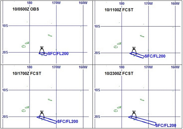 |
Figure 15. Wellington VAAC Ash Advisory maps produced to describe the Hunga Tonga-Hunga Ha'apai plume and its trajectory. Times and dates are UTC (e.g., "10/0500Z" corresponds to 10 January 2015 at 0500 UTC). (Upper left) This is the observed ("OBS") ash plume's margin, which was traced onto this map from satellite image. This is the starting point for the subsequent forecasts. (Upper right) The forecast ("FCST") plume after 6 hours. (Lower left) The forecast plume after 12 hours. (Lower right) The forecast plume after 18 hours. Courtesy of the Wellington VAAC. [Maps extracted from NZ Met Service website (OBS-Observed; FCST, Forecasted) (http://vaac.metservice.com/vag/243040-2015_19)]. |
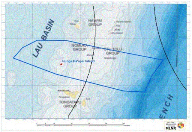 |
Figure 16.Wellington VAAC graphic showing the Hunga Tonga-Hunga Ha'apai ash plume boundararies for 12-13 January 2015 as an area enclosed in a blue polygon. The curved black lines in the center and at right are flight paths. Taken from the Wellington VAAC graphic for 12-13 January 2015. |
MIC (2015a) noted that all international flights on 13 January 2015 were cancelled, though the domestic airline was operational. A Tongan government daily media release on 13 January described the ongoing eruption and cancellation of flights: "Activity continues at the Hunga Ha'apai-Hunga Tonga region and the emission of ash is reported to have escalated. Volcanic ash is forecasted to reach 870 km in 80 km wide toward the ESE from the Hunga Ha'apai-Hunga Tonga Region. By 11 January 2015, Real Tonga Airlines cancelled their flights for the day." Similar discussions of flight cancellation occurred around this time in Matangi Tonga, in their reports for 9, 13, 14 January.
On 13 January 2015 the Australian Aviation blog reported numerous flight cancellations, including Air New Zealand, Fiji Airways, and Virgin Australia. They also reported resumed service on 14 January 2015. According to Matangi Tonga (2015a) flights resumed on 15 January.
MIC (2015b, one of two reports issued on 19 January) discussed a site inspection on 14 January using a Tongan Navy vessel. The 14 January observations conveyed in MIC (2015b) noted that continuous volcanic eruptions had created a new island (figure 17). On 14 January the volcano was erupting about every five minutes. Ash and rock were ejected to a height of about 400 m above the sea surface. Wet ash was deposited close to the vent, building up the new island. Hazardous surges of ash and steam spread out horizontally during eruptions, and extended more than 1 km from the erupting vent (figure 18). Ash and acid rain fell in an area of ~10 km surrounding the eruption.
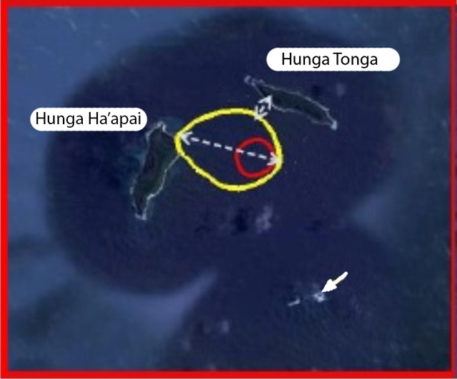 |
Figure 17. Sketch map of Hunga Tonga-Tonga Ha'apai as seen during a 14 January 2015 site inspection. The arrow points to the initial vent seen on 20 December 2014. The red circle indicates the location of the later vent that erupted for about a month, constructing an island with above water extent on 14 January 2015 in the area within the yellow circle. The circle is roughly 2 km in longest dimension. On the basis of this map, the minimum distance between Hunga Tonga island and the new land scales to ~300 m. Modified from MIC (2015b). |
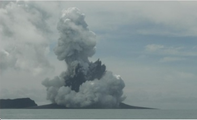 |
Figure 18. The new island amid eruption on 14 January 2015. The view is looking NE and the steep high area is Hunga Ha'apai island, which resides in behind the new island. The plume was made up of discrete white and dark components. From this perspective the vent appears to sit in the midst of the new low island. Photo taken on 14 January 2015 from the Tongan naval vessel ~300 m offshore (MIC, 2015b). |
MIC (2015b) noted that on 14 January steam rose over 1 km and was noted by pilots. The eruption continued to emit ash but in recent days the presence of ash has been limited to low elevations. An early summary section in the report also include the following.
"The new island is more than 1 km wide, ~2 km long and about 100 m high. During our observations the volcano was erupting about every 5 minutes. Dense ash was being erupted to a height of about 400 m, accompanied by some large rocks. Higher we observed mostly steam, but with some ash. Above about 1000 m, the eruption plume was almost exclusively steam. As the ash is very wet, most is being deposited close to the vent, building up the new island.
"Hazardous surges of ash and steam were seen to spread out horizontally during eruptions, and these extended more than 1 km from the erupting vent.
"Ash fall and acidic rain was observed within 10 km of the eruption. Leaves on trees on Hunga Tonga and Hunga Ha'apai have died, probably caused by volcanic ash and gases.
"No large rafts of pumice or other floating volcanic debris were observed. Strong smells of volcanic gases were noticed on a few occasions.
"This eruption is similar to that at Hunga Ha'apai in 2009, but only producing larger volume of materials resulting in the size of the island.
"It is unclear at this stage if there is any relationship between the eruption and a red algal bloom observed in seawaters around Tonga recently."
Field (2015) contained an image from the 14 January site inspection (figure 19).
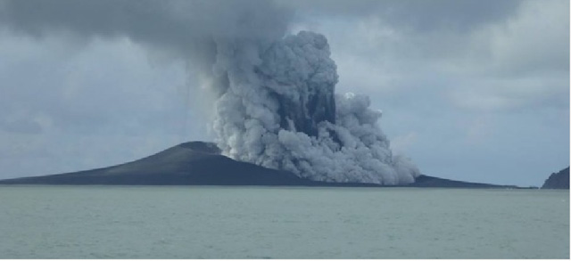 |
Figure 19. Hunga Tonga-Hunga Ha'apai eruption viewed from a Tongan naval vessel N of the island on 14 January 2015. Taken from Field (2015) with photo credit there given to the New Zealand High Commission in Tonga. |
On 14 January Matangi Tonga (2015b) reported more details on the algal bloom mentioned above (the cause of which remains uncertain). Matangi Tonga (2015b) also reported unusual optical effects seen on the E facing side at the NE end of Tongatapu island (Kanokupolu beach) around that time. The article said the bloom "...turned the seas frothy white, chocolate and red..." and "...the sun shone through a champagne sky." The article contained photos by Shane Egan documenting these effects. Algal blooms can in some cases be detected and tracked by remote sensing as exemplified by Mantas and others (2011), who discuss remote sensing of algal communities as a possible cause of discolored water associated with the Home Reef eruption of 2006.
MIC (2015c) discussed a site visit conducted aboard a naval vessel on 17 January 2015. The authors noted that the eruption still continued at the new island during the visit. MIC (2015c) further stated the following. "During most of our time near the island, strong emission of steam to heights of 7–10 km was observed, but with only limited amounts of ash. Later, some eruptions that threw dense, wet ash, and small rocks 200-300 m into the air, accompanied by further strong emissions of steam. Hunga Tonga and Hunga Ha'apai islands were covered by ash from the eruption over the last month. The eruptions observed today were too small to deposit ash on those islands, suggesting that the eruptions a week or two ago were probably substantially stronger than those observed [on the 17 January site visit]. No trace of rafts of pumice or other floating volcanic debris was observed. No strong smells of volcanic gases were noticed within 3.7 km of the site, it was noticed however 27-47 km on the way to the site. The style of this eruption is similar to that at Hunga Ha'apai in 2009, but the volume of material erupted this time is much greater. International and domestic flights have operated without interruption in the last few days."
On 19 January 2015, the Pléiades satellite captured the Hunga Tonga-Hunga Ha'apai eruption. France's Centre National d'Etudes Spatiales (CNES) issued the resulting 50 m resolution images of the new land created by Hunga Tonga-Hunga Ha'apai's latest eruptions (figure 20). Hunga Tonga island in on the upper right; and Hunga Ha'apai, center left. In the center of the image is a nearly circular, gray colored area, which is the newly created land attached to Hunga Ha'apai island. The vent area on the new island was filled with water (green). Ash from the eruption covered extensive areas of the vegetation on both islands. This and other Images were featured in the article Airbus Defense and Space (2015).
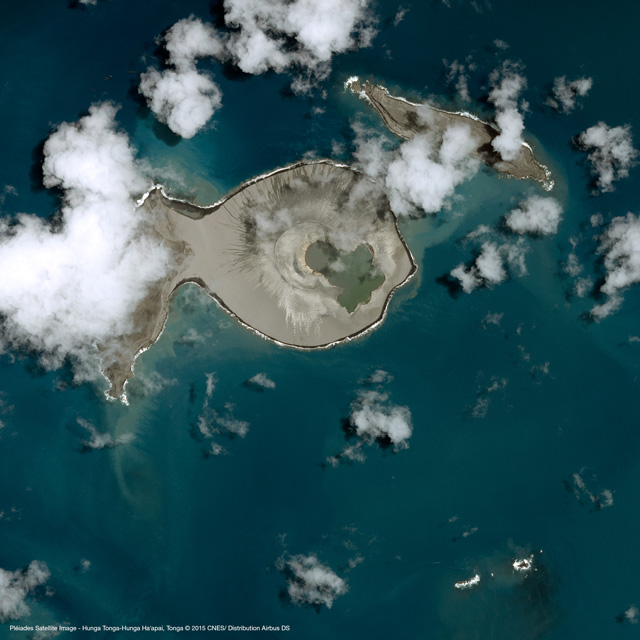 |
Figure 20. CNES Pléiades satellite image (50-m resolution, optical band) taken on 19 January 2015. Ejecta from the new crater connects it to the E side of Hunga Ha'apai (island at left). Taken Airbus Defense and Space (2015) with data acquisition credit to CNES. |
MIC (2015d) was issued on 28 January 2015 summarizing a 24 January site visit, which found the eruption over by this time. Figure 21 shows where the new land surface joins the preexisting Hunga Ha'apai island. Rough seas prevented landing and limited the trip to observations from the naval vessel. The scientists stated, "The eruption from the new island that started growing over a month ago appears to be over. There were no sign of any emissions of ash, gas or steam observed coming out from the vent of the newly formed island."
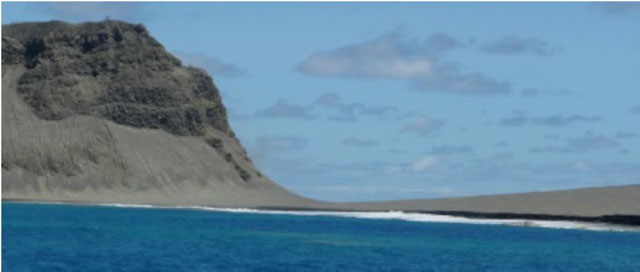 |
Figure 21. The point where new land adjoins the older island as seen in January 2015 after the Hunga Tonga Hunga Ha'apai eruption was over. The steep sea cliff forming the old margin of Hunga Ha'apai island is on the left. In the center and right parts of the image lie a low area of gently sloping gray material, which is an outer portion of the newly created land. Besides creating the new land, ash from the eruption covered vegetation over extensive areas on both the older islands. Taken from MIC (2015d). |
On 13 March 2015, Luntz (2015) reported that on 6 March 2015 GP Orbassano and two other residents of Tonga landed on one of the new land's three beaches. With his son, he climbed to the highest point of the island's crater, which was ~250 m high. According to Luntz (2015), Tonga's lands and Natural Resources Ministry said the newly formed island was 1.3 km long and 800 m wide.
Orbasano smelled sulfurous and other chemical odors. The vent had filled with opaque green water (figure 22). Matangi Tonga (2015c) also reported on this same topic and featured numerous photos.
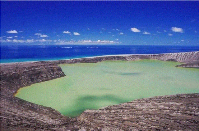 |
Figure 22. The crater lake in the vent area located in the central area of new land as seen on 6 March 2015. Courtesy of Luntz (2015) with photo credit to GP Orbassano. |
Luntz (2015) quoted Orbassano as saying "the ash and rock surface was difficult to walk on due to the channels cut in it" (figure 23).
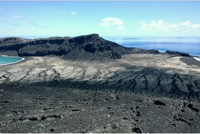 |
Figure 23. The highest peak on the new land as seen as seen on 6 March 2015. Note extensive rills and gullies. Taken from Luntz (2015) with photo credit to GP Orbassano. |
"There are thousands of seabirds--all kinds, laying eggs on the island," Orbassano said (figure 24).
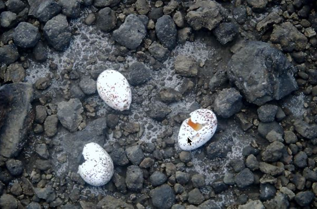 |
Figure 24. On the new land surface at Hunga Tonga-Hunga Ha'apai, these sea bird eggs were found laid directly upon the fragmental deposits. Taken on 6 March 2015. Courtesy of Iflscience and GP Orbassano. |
References. Allen, J, and Riebeek, H, 2009, Submarine Eruption in the Tonga Islands NASA image, (28 March 2009, NASA Earth Observatory, Image of the Day) NASA (URL: http://earthobservatory.nasa.gov/IOTD/view.php?id=37657) (accessed May 2015)
Australian Aviation, 2015, Volcano ash cloud disrupts Tonga flights, Australianaviation.com.au (posted 13 January 2015) (accessed May 2015) (URL: http://australianaviation.com.au/2015/01/volcano-ash-cloud-disrupts-tonga-flights/ )
Airbus Defense and Space, 2015, Eruption of a volcano in the Tonga archipelago, Pléiades captures the birth of a new island (accessed March 2015) (URL: http://www.geo-airbusds.com/en/6322-eruption-of-a-volcano-in-the-tonga-archipelago-pleiades-captures-the-birth-of-a-new-island)
Bohnenstiehl D.R., Dziak R.P., Matsumoto H., Lau T.K. Underwater acoustic records from the March 2009 eruption of Hunga Ha'apai–Hunga Tonga volcano in the Kingdom of Tonga. J. Volc. Geotherm. Res. 2013;249:12-24.
Culture Volcan (Journal d'un volcanophile), 2015, L'activité du volcan Hunga Tonga Hunga Ha'apai a-t-elle changé de style? (posted 14 January 2014) (URL: http://laculturevolcan.blogspot.com/2015/01/lactivite-du-volcan-hunga-tonga-hunga.html)
Field, M, 2015, Tonga volcanic eruption creates new island, Stuff.co, posted 16 January 2015 (URL: http://www.stuff.co.nz/world/south-pacific/65103454/tonga-volcanic-eruption-creates-new-island ).
Klemetti, E, 2014, New Eruption at Hunga Tonga-Hunga Ha'apai, Wired (online), posted 30 December 2014 (accessed 6 June 2015).
Luntz, S, 2015, Newly emerged Pacific "Island" photographed for the first time, IFLSCIENCE (posted 13 March 2015. Accessed March 2015 (URL: http://www.iflscience.com/physics/newly-emerged-pacific-peak-photographed-first-time).
Mantas, V M, Pereira, AJSC., and Morais, PV, 2011, Plumes of discolored water of volcanic origin and possible implications for algal communities. The case of the Home Reef eruption of 2006 (Tonga, Southwest Pacific Ocean). Remote Sensing of Environment, v. 115, no. 6, p. 1341-1352.
Matangi Tonga, 2014, Hunga Ha'apai eruption continues, Matangi Tonga (Posted 30 December 2014; free content accessed in May 2015) (URL: http://matangitonga.to/2014/12/30/hunga-haapai-eruption-continues).
Matangi Tonga, 2015a, Fua'amotu airport's busiest day, as flights resume, Matangi Tonga (Posted 15 January 2015; free content accessed in May 2015) (URL: https://matangitonga.to/2015/01/15/fuaamotu-airports-busiest-day-flights-resume).
Matangi Tonga, 2015b, Nature plays with the sea and sky in Tonga, Matangi Tonga (Posted 15 January; free content accessed in May 2015) (URL: http://matangitonga.to/2015/01/15/nature-plays-sea-and-sky-tonga).
Matangi Tonga, 2015c, New volcanic island attracts sightseers, Matangi Tonga (Posted 9 March 2015; free content accessed in May 2015) (URL: http://matangitonga.to/2015/03/09/new-volcanic-island-attracts-sightseers).
MIC, 2015a, Government of Tonga Ministry of Information and Communication 3 (issued 14 January 2015) (URL: http://www.mic.gov.to/news-today/press-releases/5180-advisory-of-volcanic-activity-no3) (Accessed April 2015).
MIC, 2015b, Government of Tonga Ministry of Information and Communication 4 (issued 19 January 2015) (URL: http://www.mic.gov.to/news-today/press-releases/5185-volcanic-advisory-4) (Accessed April 2015).
MIC, 2015c, Government of Tonga Ministry of Information and Communication 5 (issued 19 January 2015) URL: http://www.mic.gov.to/news-today/press-releases/5183-volcanic-advisory-5) (Accessed April 2015).
MIC, 2015d, Government of Tonga Ministry of Information and Communication 6 (issued 28 January 2015) (URL: http://www.mic.gov.to/news-today/press-releases/5197-volcanic-advisory-6) (Accessed April 2015).
Vaughan, RG, Webley, P, 2010, Satellite observations of a surtseyan eruption: Hunga Ha'apai, Tonga, Journal of Volcanology and Geothermal Research. 12/2010; 198(1-2):177-186. DOI: 10.1016/j.jvolgeores.2010.08.017.
Geological Summary. The small andesitic islands of Hunga Tonga and Hunga Ha'apai are part of the western and northern remnants of the rim (~6 km diameter) of a largely submarine caldera located about 30 km SSE of Falcon Island. The topmost sequence of welded and unwelded ignimbrite units from a caldera-forming eruption was 14C dated to 1040-1180 CE (Cronin et al., 2017; Brenna et al. 2022). At least two additional welded pumice-rich ignimbrite units and nonwelded pyroclastic flow deposits, below paleosols and other volcaniclastic deposits, indicated more very large previous eruptions (Cronin et al., 2017; Brenna et al. 2022). Several submarine eruptions have occurred at this caldera system since the first recorded eruption in 1912, including 1937 and S of the islands in 1988. A short eruption in 2009 added land to to Hunga Ha'apai. At that time the two islands were each about 2 km long, displaying inward-facing sea cliffs with lava and tephra layers dipping gently away from the caldera. An eruption during December 2014-January 2015 was centered between the islands, and combined them into one larger structure. Major explosive eruptions in late 2021 initially reshaped the central part of the combined island before stronger activity in mid-January 2022 removed most of the 2014-15 material; an even larger eruption the next day sent an eruption plume high into the stratosphere, triggered shock waves through the atmosphere and tsunami across the Pacific Ocean, and left only small remnants of the islands above the ocean surface.
Information Contacts: Tonga’s Ministry of Information and Communications (URL: http://www.mic.gov.to); Tonga’s Natural Resources Division of the Ministry of Lands and Natural Resources (URL: http://www.mic.gov.to/ministrydepartment/14-govt-ministries/lands-survey-nat-res/); Mary Lyn Fonua, Matangi Tonga online (URL: http://matangitonga.to/); NASA Earth Observatory (URL: http://earthobservatory.nasa.gov/); Wellington Volcanic Ash Advisory Centre, NZ Meteorology Service (URL: http://vaac.metservice.com/); Tonga Meteorological and Coastal Radio service (URL: http://www.met.gov.to); GNS Science (formerly New Zealand’s Institute of Geological and Nuclear Sciences Limited), Taupo, New Zealand (URL: http://www.gns.cri.nz/); and GP (Gianpiero(?)) Orbassano, Waterfront Lodge, Vuna Road, Ma'ufanga, PO Box 1001, Nuku'alofa, Tonga (URL: http://www.waterfront-lodge.com/).