Report on Ontakesan (Japan) — March 2015
Bulletin of the Global Volcanism Network, vol. 40, no. 3 (March 2015)
Managing Editor: Richard Wunderman.
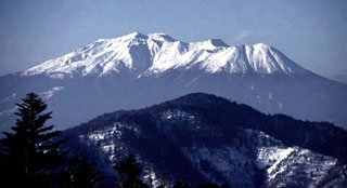
Ontakesan (Japan) Eruptions: (a) March 2007 and (b) 27 September 2014 (~60 deaths and ~70 injured)
Please cite this report as:
Global Volcanism Program, 2015. Report on Ontakesan (Japan) (Wunderman, R., ed.). Bulletin of the Global Volcanism Network, 40:3. Smithsonian Institution. https://doi.org/10.5479/si.GVP.BGVN201503-283040
Ontakesan
Japan
35.893°N, 137.48°E; summit elev. 3067 m
All times are local (unless otherwise noted)
This Bulletin report on Ontakesan (Kiso-Ontakesan, Ontake) covers activity from November 2003 to November 2014. During this reporting interval, two eruptions occurred, both broadly described as phreatic, yet containing a minor component of identified juvenile magmatic material. The first eruption was on an unknown date in late March 2007, and the second eruption was on 27 September 2014. The 2014 eruption took place with a sudden onset and with few if any precursory warnings. The volcano is a famous tourist area to see color changes in autumn foliage, it also contains considerable alpine touristic infrastructure, including lodges. The 2014 eruption took place during the autumn color season on a Saturday. Hundreds of people were on the mountain at the time. The 2014 eruption included ashfall, pyroclastic flows, and related density currents. The eruption killed ~57 people and an additional 6 were still missing as of 27 October 2014 (Kyodo, 2014). The 2014 impulsive eruption was documented by an outstanding number of close-up photographs and videos taken by eyewitnesses.
Between the 2007 and 2014 eruptions, activity receded to background levels. Our last Bulletin report (BGVN 28:11) noted occasional white plumes during 2000 to 2003.
The data for this report was collected chiefly from online reports by the Japanese Meteorological Agency (JMA), the Geological Survey of Japan (GSJ), and the National Institute of Advanced Industrial Science and Technology (AIST).
Historically, activity at Ontakesan has consisted mainly of phreatic explosions every several hundred years. However, recent research cited in JMA (date unknown) indicates that over the past 10,000 years, four magmatic eruptions have also occurred. Although there are no reported records of historical eruptions before 1979, fumarolic activity was noted as ongoing for several hundred years near to Ontakesan's summit (Jigokudani and Hachotarumi). The period of activity after 1979 represents what appears to be Ontakesan's most active during the past 250 years (Oikawa, 2008).
2006–2007. The March 2007 eruption was preceded by minor inflation and an increase in seismic activity (JMA, date unknown). During mid- to late December 2006, instruments detected inflation of the volcanic edifice and an increase in shallow seismicity directly below the summit. During January 2007, instruments recorded 90 earthquakes on the 16th and 164 earthquakes on the 17th. On 25 January 2007, tremor occurred with the largest recorded amplitude in at least a year. Tremor had, according to a JMA plot, remained near zero during all of 2006. The January 2007 tremor was described as very low frequency, containing a 15- to 20-second-long component. Furthermore, GPS observations detected a small amount of crustal deformation preceding the seismic activity, indicating a slight inflation at Ontakesan.
On 16 March 2007, fumarolic activity increased; fumes at the summit were occasionally detected by a surveillance camera (at "Mitake Kurozawa," but the exact location was not found in English on maps in Ontakesan reports). Seismic and other data considered by JMA showed that an earthquake had occurred during late March, originating directly below Ontakesan. The specific dates of the seismicity and earthquake were not specified in the available reporting. Based on the data collected, JMA inferred that the earthquake had resulted from a magmatic intrusion that had advanced toward the surface reaching ~4 km below the volcano's summit.
A field study two months later, on 29 May 2007, noted fresh volcanic ash from Ontakesan's 79-7 crater. The ash reached ~200 m NE of the crater. This finding of fresh ash was believed to indicate that the 2007 eruption was not merely phreatic but involved some escape of juvenile components to the surface. The exact date of the eruption was undeterminable.
JMA cited a model by Nakamichi and others (2009) regarding the intrusion of a magmatic body and the subsequent 2007 eruption, to describe phreatic eruptions at Ontakesan (figure 12). The depths shown reflect but one set of depth values for the top of the intrusion ((a) in this case 3 km depth below the summit) and the zone of groundwater ((b) centered at ~2.4 km depth below the summit). Thus, figure 12 illustrates a basic model of the various processes involved in a phreatic eruption, which is defined by Harris (2000) as a ". . . steam eruption that produces no fresh magma. A common precursor of eruptive activity, it is caused when groundwater, heated by a magmatic source, flashes into steam."
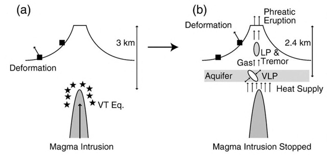 |
Figure 12. Diagrams (a and b) that JMA cited to help explain magma intrusion, steam generation, and related signals associated with a phreatic eruption. Courtesy of JMA, citing Nakamichi and others (2009). |
Figure 12a considers an earlier pre-eruptive stage, where magma advanced upward to 3 km below the volcano's summit. Volcano-tectonic (VT) earthquakes resulted from breaking rock. Note that in the March 2007 eruption, the magma was thought to have advanced to 4 km depth below the summit and the tremor noted then was very-long period (VLP, because of the above-mentioned long-period (15-20 second) component).
Figure 12b considers a later stage of the intrusion event, where the magma ceased to advance towards the surface. The magma heated the groundwater, which expanded into steam. The pressure from the heated water and steam broke rock as it advanced towards the surface. Acoustical signals include VLP and long period (LP) earthquakes. In this model, the steam escaped through the ancestral vents, thus producing a phreatic eruption.
Eruption in September 2014. Available JMA and GSJ reports say very little about the period leading up to the September 2014 eruption. According to a news source (Asahi Shimbun, 2014b), during the early part of September, daily tremor peaked at 85 on 11 September and were followed by 3 to 27 tremor events per day starting on 12 September.
The JMA Executive Committee (2014) reported that on the morning of 27 September, a few hours before the eruption at 1152 Local Time (LT=UTC+9), there was no major unrest. They did record mild seismic events, tilt, and increased steaming; the noted data appearing from 1130 to 1210. The report noted that seismic signal recorded 11 minutes prior to the eruption was nearly flat, with only one small event, in contrast to the robust signal associated with the subsequent eruption. Tilt began 7 minutes prior to and peaked during the explosion.
GSJ (2014) stated: "A volcanic eruption occurred on September 27, 2014 at Mount Ontake on the border between Nagano and Gifu Prefectures. According to the Japan Meteorological Agency, the eruption began at about 11:52 JST [Japan Standard Time] (=UTC+9h) on September 27. It is estimated that the plume from this eruption reached a maximum height of 7000 m, and a pyroclastic flow cascaded down the mountain in a southwesterly direction for a distance of more than 3 km."
Additionally, about forty minutes later, the Tokyo Volcanic Ash Advisory Center (VAAC) noted that the plume resulting from the eruption ascended to 11 km above sea level (a.s.l.) extending to the E. The JMA raised the Alert Level to 3, and the level remained elevated throughout the reporting interval. Figure 13 provides an oblique view of the volcano with the approximate area of the eruption and the summit mountain lodge labelled.
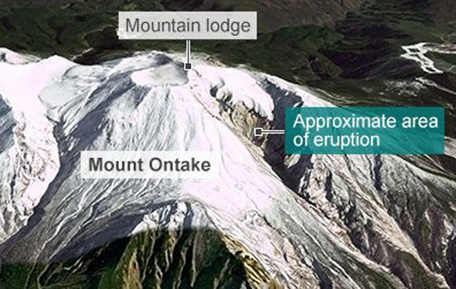 |
Figure 13. A DigitalGlobe Google image of Ontakesan with a label indicating the approximate area where the sudden eruption vented (on the S flank). For scale, the prominent crater atop this part of the cone is ~200 m in diameter. Several bodies were found within the mountain lodge and other infrastructure on and near the summit rim. Courtesy of BBC (2014b). |
The 27 September eruption was captured by a camera system (Yamamoto, 2014; AIST, 2014b; GSJ, 2014) (figure 14). The term pyroclastic flow generally applies to laterally moving mixtures of hot gas and particles such as tephra and lithics; a broader term that includes ash cloud surges, etc. is pyroclastic density current (see Roche, 2015, and the references therein). In the case of the 2014 eruption, density currents occurred near the summit and on the western flank; some of the complexity may have been due to secondary explosions well downslope of the vent area (AIST, 2014b; Boyle and others, 2014). The density currents descended at variously reported maximum speeds of 30 to 72 km per hour (AIST, 2014b; Yamamoto, 2014). According to Boyle and others (2014), the pyroclastic density currents traveled more than 3 km down Ontakesan's S flank.
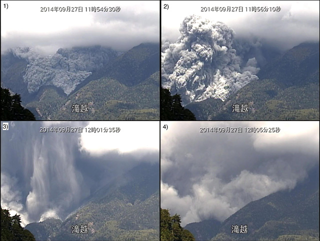 |
Figure 14. Four photos of the Ontakesan 2014 eruption captured by the Chubu Regional Development Bureau's camera at Takigoshi on 27 September. [1] (1154 LT) The pyroclastic flow descended. [2] (1156 LT) A secondary plume rose. [3] (1201 LT) The plume released a downburst of ash. [4] (1205 LT) The plume developed laterally, spreading along the ground surface. Taken from Yamamoto (2014). |
On 28 September, the day following the eruption, the GSJ conducted several aerial observations, utilizing media helicopters (GSJ, 2014). At 0800 LT, the height of the plume was ~500 m, heading S to SW. The scientists noted the eruption formed a new line of craters (figure 15) running NW to SE. These new craters resided 250–300 m to the SE of those formed during a previous eruption in 1979. The line of craters is roughly parallel to the 1979 line, but covers a wider area.
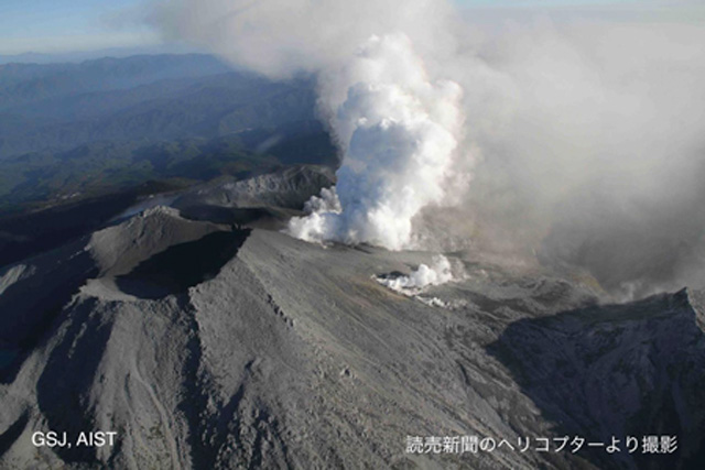 |
Figure 15 Aerial view of Ontakesan from 28 September at 1636 LT. The Kengamine summit area, as depicted from the NW, released white plumes heading S to SE. The smaller plume in the foreground originated from a fissure crater on the W end of the new line of craters. The distant plume originated from the line of craters formed at Jigokudani, located SW of the summit . Additional photos of the eruption, similar to this one, are provided by the authors. Source: GSJ (2014). |
GSJ also conducted expeditions to the Kaida Plateau, located ~6 km E to NE of the Kengamine summit, and collected ash samples on 28 September. A photo depicted in GSJ (2014) shows a light coating (on the order of several millimeters) of gray ash covering the leaves and horizontal surfaces of plants in the region. The geologists described the ash as "medium-to-fine-grain sand-sized particles" with a maximum diameter of 0.5 mm. Most of the ash was altered rock fragments and less than 10% was unaltered red-orange and crystalline fragments (as seen in figure 16). GSJ (2014) reported that, as a result of this ash analysis, the recent eruption was considered as phreatic (rather than predominantly magmatic).
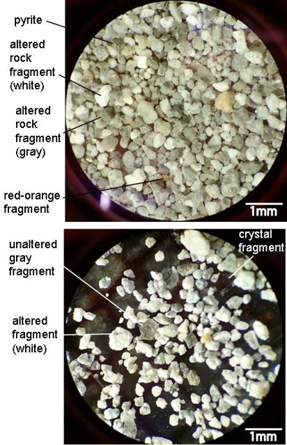 |
Figure 16. Samples collected at Ontakesan. (Top) A majority of this ash sample was altered. (Bottom) A sample with some fragments of unaltered ash. The AIST report also includes a detailed description of the methods used to gather/ analyze ash samples. Courtesy of AIST (2014a). |
GSJ (2014) also noted that scientists had charted the main axis of ash fall from the 2014 eruption, based on the findings from their expeditions. The ash distribution extended towards Ontakesan's E to NE (red arrow, figure 17).
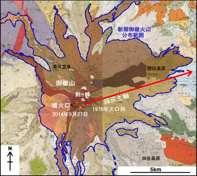 |
Figure 17. Geological map of Ontakesan containing annotations relevant to the 2014 eruption. The main axis of ash distribution is noted by the red arrow. The line of craters formed by the 2014 eruption are marked approximately by a series of small red dots and a yellow line near the base of the red arrow. The 1979 line of craters is depicted as a row of green dots. The blue line denotes the known margin of the Younger Ontake Volcano formed ~100,000 years ago. Source: GSJ (2014). |
News sources contributed the following. The ash resulting from the eruption was ~50 cm thick near the crater and up to 20 cm thick in lower areas (Adonai, 2014). Asahi Shimbun (2014b) also quoted a scholar, Takayuki Kaneko, as allegedly stating that the ash was "moist" and stuck together like "sesame seeds."
According to JMA, from 1 to 7 October, Ontakesan continued to emit ash, but the resultant plume height could not be determined due to poor visibility. On 7 October, the plume was observed to rise 300 m above the crater rim, drifting E. Tremor continued to be detected; the number of earthquakes detected from 27 September to 6 October are compiled in figure 18 (JMA daily reports).
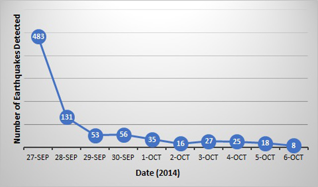 |
Figure 18. The number of earthquakes detected per day during 27 September to 6 October 2014. Data courtesy of JMA (daily reports); figure by Bulletin editors. |
According to JMA, Ontakesan emitted ash plumes during 8–9 October, white plumes on 10 October, and plumes with only small amounts of ash during 10–14 October. During 8–14 October, tremors were below the detection limits. White plumes rose 100–200 m above the crater rim, drifting NE and SE, during 16–18 October. On 19 October, plumes rose to 600 m above crater.
Impact of eruption on people. As previously mentioned, according to news sources, the 27 September eruption killed 57 hikers on Ontakesan's slopes, and as of 27 October another 6 were missing (Kyodo, 2014). Furthermore, more than 70 were injured (RT, 2014). According to the Associated Press in Tokyo (2014), the explosion was the deadliest volcanic eruption in Japan in the post-WWII period.
According to the BBC (2014a), nearly 300 people were hiking on Ontakesan on the day of the eruption. The news article characterized the accounts of the eruption as consisting of falling ash and boulders, at times with sufficient density to cause several minutes of total darkness. Kuroda Terutoshi (Kuroda Terutoshi, 2014), posted a video of the eruption to YouTube that he took while hiking. The expanding ash plume engulfed a cabin on the slopes above him, and he was soon surrounded by the plume, which included dark ballistics and ashfall. The ash plume grew rapidly and continued downhill, as depicted in two other videos (Asahi Shimbun, 2014a and BBC News, 2014).
Boston Globe (2014) stated that rescue and recovery missions began on 28 September deploying more than 500 Japanese military and police. Metal and landmine detectors played a role in locating victims buried under ash (Asahi Shimbun, 2014c). National Geographic (2014) and Ogrodnik (2014) provide several photos of the rescue missions, derived from various news sources. According to Malm (2014), several of the casualties found during rescue operations were "still holding their smartphones." Lies and Meyers (2014) noted the halting of some initial search and recovery efforts on 30 September owing to increased tremor the night before raising concerns then about the return of volcanic activity.
On 6 October, Typhoon Phanfone (No. 18) came near to the Ngano Prefecture where Ontakesan is located (Asahi Shimbun, 2014b, c). Accompanied by heavy rains, a mixture of volcanic ash and rain formed into mud, making it hard for large helicopters to land near the summit. Rescue missions were halted on 15 October due to the wintery conditions despite people still missing. The article said that the search for bodies was expected to resume in the springtime.
References. T (?Pfeiffer, T), 2014, Ontake-san volcano (Japan): death toll from yesterday's eruption rises to more than 30, 28 September 2014, Volcano Discovery (URL: http://www.volcanodiscovery.com/on-take/news/48168/Ontake-san-volcano-Japan-death-toll-from-yesterday-s-eruption-rises-to-more-than-30.html) [accessed in June 2015]
AIST, 2014a, Analysis of Volcanic Ash Falling from the September 2014 Eruption of the Ontake Volcano, 28 September 2014, National Institute of Advanced Industrial Science and Technology (URL: https://www.gsj.jp/hazards/volcano/kazan-bukai/yochiren/ontake_ash_140928E.pdf)
AIST, 2014b, The Pyroclastic Flow Generated by the September 27, 2014 Eruption of the Ontake Volcano, 29 September 2014, National Institute of Advanced Industrial Science and Technology (URL: https://www.gsj.jp/hazards/volcano/kazan-bukai/yochiren/ontake_flow_140928E.pdf)
Asahi Shimbun, 2014a, Ontakesan eruption prediction was difficult, the Japan Meteorological Agency did not find any omens, 27 September 2014 (URL: http://www.asahi.com/articles/ASG9W5KFJG9WULBJ00D.html) [accessed in June 2015]
Asahi Shimbun, 2014b, Volcanologists: with few telltale signs, Mt. Ontakesan's eruption hard to predict, 28 September 2014, (URL: http://ajw.asahi.com/article/behind_news/social_affairs/AJ201409280022) [accessed in June 2015]
Asahi Shimbun, 2014c, Update: More victims of Mt. Ontakesan eruption found as typhoon nears, 4 October 2014 (URL: http://ajw.asahi.com/article/behind_news/social_affairs/AJ201410040056)
Associated Press in Tokyo, 2014, Hikers killed by Japanese volcano left poignant pictures of final moments, 5 October 2014, The Guardian (URL: http://www.theguardian.com/world/2014/oct/05/-sp-hikers-killed-japanese-volcano-pictures-final-moments) [accessed in June 2015]
Australian Associated Press with Australia Geographic staff, 2014, Japan Volcano Ontake an Extremely Rare Eruption, 29 September 2014, Australia Geographic (URL: www.australiangeographic.com.au/news/2014/09/japan-volcano-ontake-an-extremely-rare-eruption) [accessed in June 2015]
BBC News, 2014, Video: Japan volcano shoots rock & ash on Mount Ontake - BBC News, 29 September 2014, YouTube (URL: https://www.youtube.com/watch?v=aQtkoLxqUNQ) [accessed in June 2015]
BBC, 2014a, Japan's Mount Ontake volcanic eruption injures 30, 27 September 2014, British Broadcasting Corporation (URL: http://www.bbc.com/news/world-asia-29392810) [accessed in June 2015]
BBC, 2014b, Japan Mount Ontake Volcano: Death Toll Reaches 47, 1 October 2014, British Broadcasting Corporation (URL: www.bbc.com/news/world-asia-29440982) [accessed in June 2015]
Boston Globe, 2014, Military Helicopters Rescue People Stranded After Mt Ontake Eruption, 28 September 2014, Boston.com (URL: http://www.boston.com/news/world/asia/2014/09/28/military-helicopters-rescue-people-stranded-after-ontake-eruption/iW6wHPhW5K0rAsYM0EUe7H/video.html) [accessed in June 2015]
Boyle, D., Charlton, C., 2014, 36 Now Feared Dead in Japanese Volcano Disaster, 28 September 2014, Daily Mail (URL: http://www.dailymail.co.uk/news/article-2772458/More-30-hikers-dead-near-Japanese-volcano-erupted-without-warning-spewinf-eight-inch-blanket-ash.html) [accessed in June 2015]
GSJ, 2014, Ontake Volcano Information, 7 October 2014, Geological Survey of Japan (URL: https://www.gsj.jp/en/hazards/ontake2014/index.html) [accessed in June 2015]
Harris, 2002, Archaeology and volcanism, in The encyclopedia of volcanoes. Sigurdsson, H., Houghton, B., McNutt, S., Rymer, H., and Stix, J. (Eds.). pp. 1301-1314. Elsevier.
JMA, date unknown, 53. Ontakesan, Japan Meteorological Agency (JMA) (URL: http://www.data.jma.go.jp/svd/vois/data/tokyo/STOCK/souran_eng/volcanoes/053_ontakesan.pdf) [accessed in June 2015]
JMA Executive Committee, 2014, Prediction of Volcanic Eruptions Coordinating Committee Expanded Executive Committee, 21 pages, 28 September 2014, Japan Meteorological Agency (JMA) (URL: www.data.jma.go.jp/svd/vois/data/tokyo/STOCK/kaisetsu/CCPVE/shiryo/kakudai140928/kakudai140928_no01.pdf)
Kuroda Terutoshi, 2014, Ontake Eruption, original, 26 September 2014, YouTube (URL: https://www.youtube.com/watch?t=77&v=7Ea3uED1Zgc) [accessed in June 2015]
Kyodo, 2014, Ontake victims mourned a month after eruption as tourism industry scrambles to recover, 27 October 2014, Japan Times (URL: http://www.japantimes.co.jp/news/2014/10/27/national/ontake-victims-mourned-month-eruption-tourism-industry-scrambles-recover/) [accessed in June 2015]
Lies, E. and Meyers, C., 2014, Recovery of Japan Volcano Victims Suspended Amid Signs of Rising Activity, 30 September 2014, Reuters (URL: www.reuters.com/article/2014/09/30/us-japan-volcano-idUSKCN0HP07G20140930) [accessed in June 2015]
Nakamichi, H., Kumagai, H., Nakano, M., Okubo, M., Kimata, F., Ito, Y., Obara, K., 2014, Source mechanism of a very-long-period event at Mt Ontake, central Japan: Response of a hydrothermal system to magma intrusion beneath the summit, 10 November 2009, Journal of Volcanology and Geothermal Research (URL: http://www.sciencedirect.com/science/article/pii/S0377027309003588)
Malm, S., 2014, One last picture... that cost their lives: More than half the victims killed by erupting volcano in Japan were found clutching smartphones, 12 November 2014, Daily Mail (URL: http://www.dailymail.co.uk/news/article-2831305/One-selfie-cost-lives-half-victims-killed-erupting-volcano-Japan-clutching-smartphones-photos-lava-coming-them.html) [accessed in June 2015]
National Geographic, 2014, Pictures: Japanese Volcano that Killed Hikers, 29 September 2014 (URL: http://news.nationalgeographic.com/news/2014/09/pictures/140929-japan-volcano-ontake-pictures/) [accessed in June 2015]
Ogrodnik, I., 2014, IN PHOTOS: Powerful images as Japanese Volcano Mount Ontake Erupts, 1 October 2014, Global News (URL: http://globalnews.ca/news/1587737/in-photos-powerful-images-as-japans-mount-ontake-erupts/) [accessed in June 2015]
Oikawa, T., 2008, Re-examination of historical records and fumarolic activity of eruption records of the Ontake volcano, Japanese with English abstract, Geological Survey of Japan (GSJ) (URL: https://www.gsj.jp/data/bulletin/59_05_01.pdf)
Roche, O., 2015, Nature and Velocity of Pyroclastic Density Currents Inferred from Models of Entertainment of Substrate Lithic Clasts, Earth and Planetary Science Letters, 418, 115-125 (URL: http://adsabs.harvard.edu/abs/2015E&PSL.418..115R)
RT, 2014, Volcano erupts in central Japan, dozens injured (VIDEO, PHOTOS), 27 September 2014 (URL: http://rt.com/news/191124-japan-volcano-erupts-injured/) [access in June 2015]
Yamamoto, T., 2014, The Pyroclastic Density Currents Generated by the September 27, 2014 Phreatic Eruption of Ontake Volcano, Bulletin of the Geological Survey of Japan, number 65 (URL: https://www.gsj.jp/data/bulletin/65_09_03.pdf)
Geological Summary. The massive Ontakesan stratovolcano, the second highest volcano in Japan, lies at the southern end of the Northern Japan Alps. Ascending this volcano is one of the major objects of religious pilgrimage in central Japan. It is constructed within a largely buried 4 x 5 km caldera and occupies the southern end of the Norikura volcanic zone, which extends northward to Yakedake volcano. The older volcanic complex consisted of at least four major stratovolcanoes constructed from about 680,000 to about 420,000 years ago, after which Ontakesan was inactive for more than 300,000 years. The broad, elongated summit of the younger edifice is cut by a series of small explosion craters along a NNE-trending line. Several phreatic eruptions post-date the roughly 7300-year-old Akahoya tephra from Kikai caldera. The first historical eruption took place in 1979 from fissures near the summit. A non-eruptive landslide in 1984 produced a debris avalanche and lahar that swept down valleys south and east of the volcano. Very minor phreatic activity caused a dusting of ash near the summit in 1991 and 2007. A significant phreatic explosion in September 2014, when a large number of hikers were at or near the summit, resulted in many fatalities.
Information Contacts: Japan Meteorological Agency (JMA), Otemachi, 1-3-4, Chiyoda-ku Tokyo 100-8122, Japan (URL: http://www.jma.go.jp/); Tokyo Volcanic Ash Advisory Center (VAAC), Tokyo, Japan (URL: http://ds.data.jma.go.jp/svd/vaac/data/)