Report on Ambrym (Vanuatu) — June 2015
Bulletin of the Global Volcanism Network, vol. 40, no. 6 (June 2015)
Managing Editor: Edward Venzke.
Edited by A. Elizabeth Crafford.
Ambrym (Vanuatu) New eruption with lava flow on 20 February 2015
Please cite this report as:
Global Volcanism Program, 2015. Report on Ambrym (Vanuatu) (Crafford, A.E., and Venzke, E., eds.). Bulletin of the Global Volcanism Network, 40:6. Smithsonian Institution. https://doi.org/10.5479/si.GVP.BGVN201506-257040
Ambrym
Vanuatu
16.25°S, 168.12°E; summit elev. 1334 m
All times are local (unless otherwise noted)
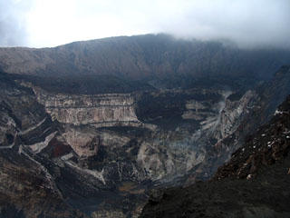
Ambrym is a large basaltic volcano, with two lava lakes (figure 29) that have been almost continuously active since May 2008 contained in the 12-km-wide summit crater; MODIS data shows that they have remained active through at least June 2015. The Vanuatu Geohazards Observatory (VGO) issues periodic updates for the population of ~7000 island residents, and monitors seismicity using one permanent station. It also regularly emits ash plumes affecting air navigation, spreads clouds of vog across the island (BGVN 39:04), and occasionally has reported lava flows. The dramatic nature of the lava lakes makes it a popular destination with volcano tourists.
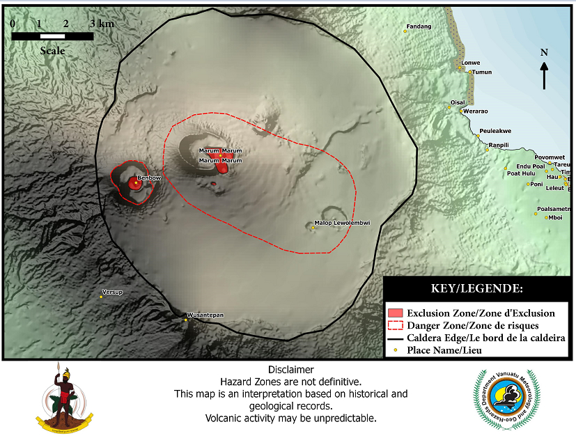 |
Figure 29. Main crater area of Ambrym volcano showing smaller craters and lava lakes as well as the danger and exclusion zones. Image courtesy of VGO. |
Steam-and-gas plumes were previously detected in satellite imagery on 9 August 2013 and 7 January 2014 (BGVN 39:04). On 11 September 2014, VGO reported increased seismicity and raised the Alert Level from 1 to 2 (on a scale of 0-4). On 8 December 2014, VGO reported that observations and analyses of Ambrym conducted during November and early December showed that activity levels had slightly decreased and consequently, the Alert Level was lowered to 1. An expedition to the Benbow lava lake by Volcano Discovery in September 2014 confirmed active lava fountaining from the lake.
On 21 February 2015, VGO issued a notice reporting an eruption from a new vent; the Alert Level was raised to 3 (on a scale of 0-5, see figure 30). Aura.OMI SO2 data from NASA first shows an anomaly between 0113 and 0255 UTC on 21 February. By 23 February an SO2 plume extending about 800 km WSW past northern New Caledonia is recorded. The plume then drifts ~600 km to the SSE by 25 February as it dissipates. Only the slightest trace is still visible to the SE of the volcano on 26 February. Satellite images indicated that the eruption location was southwest of Lewolembwi crater inside the caldera (figures 29, 31). The LANDSAT images taken in February and March 2015, and compared with an image from May 2014, annotated by Culture Volcan, show the eruption in progress and the extent and distribution of the new lava flow.
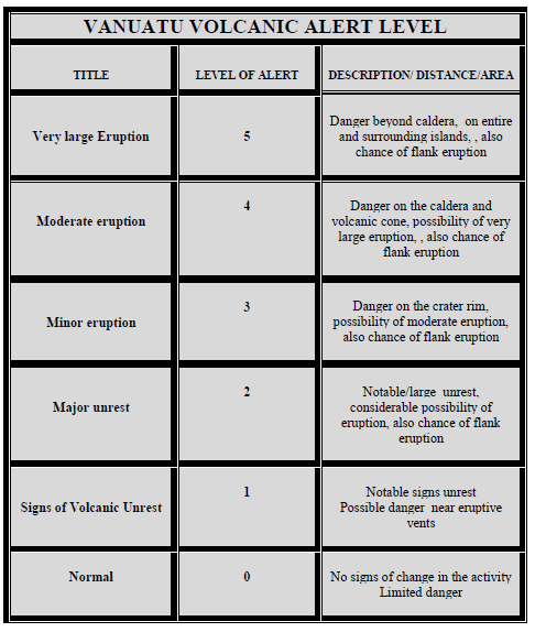 |
Figure 30. Vanuatu Volcanic Alert Level descriptors as of February 2015. Courtesy of VGO. |
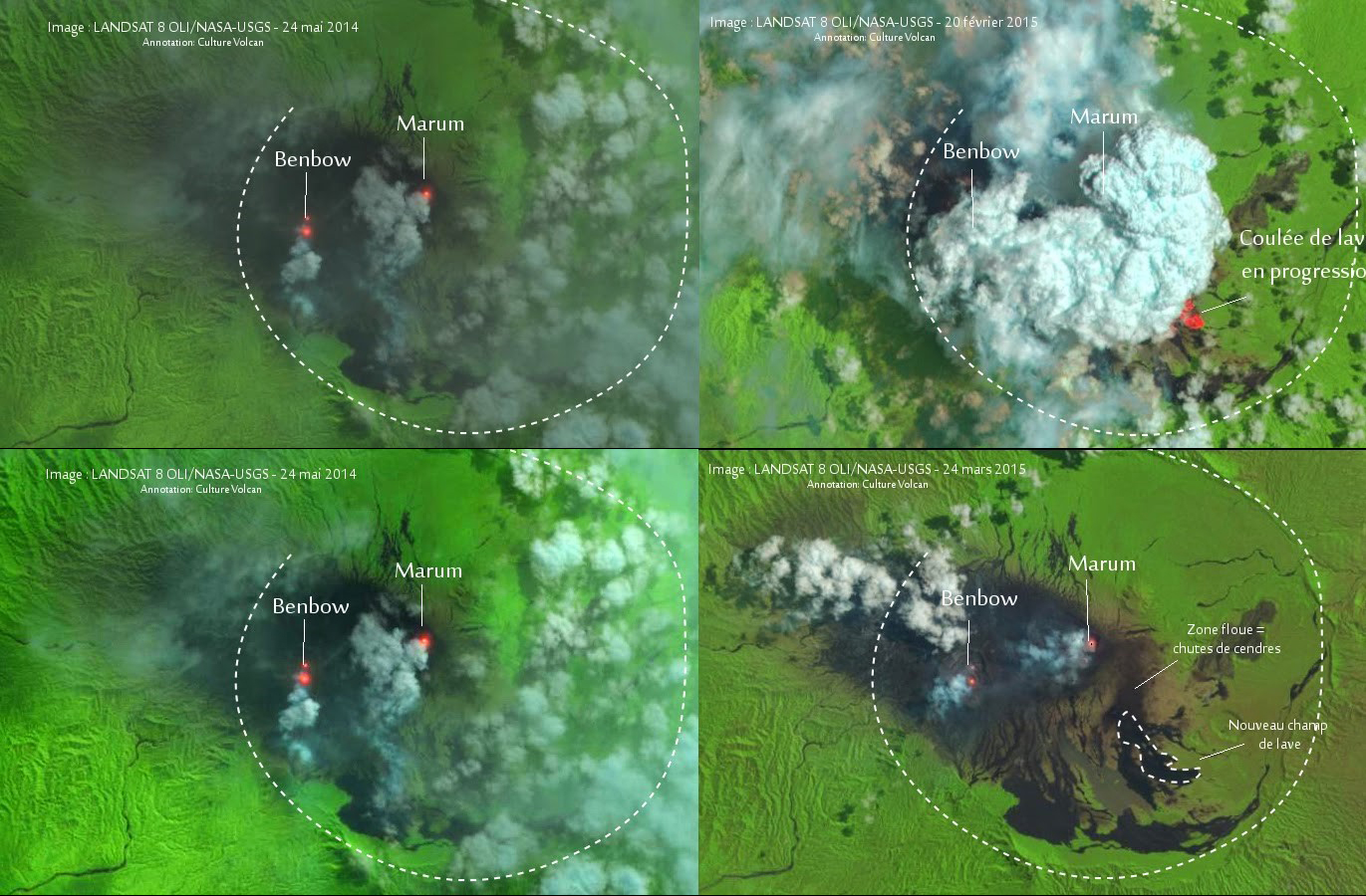 |
Figure 31. LANDSAT images of Ambrym eruption of 20/21 February, 2015. Upper and lower left images are both 24 May 2014, before the eruption. Upper right image taken 20 February 2015, shows ash plume and lava flow in progress. Lower right image from 24 March 2015, shows area of new flow outlined in white and labelled "Nouveau champ de lave". Images Courtesy of LANDSAT 8 OLI/NASA-USGS and Culture Volcan, Annotations courtesy of Culture Volcan. |
Culture Volcan reported that the Vanuatu National Disaster Management Office (NDMO) visited Ambrym on 22 February 2015. Ben Clark, Chief Pilot for Vanuatu Helicopters, photographed the new lava flow (figure 32), and lava fountains from the eruption in progress (figure 33).
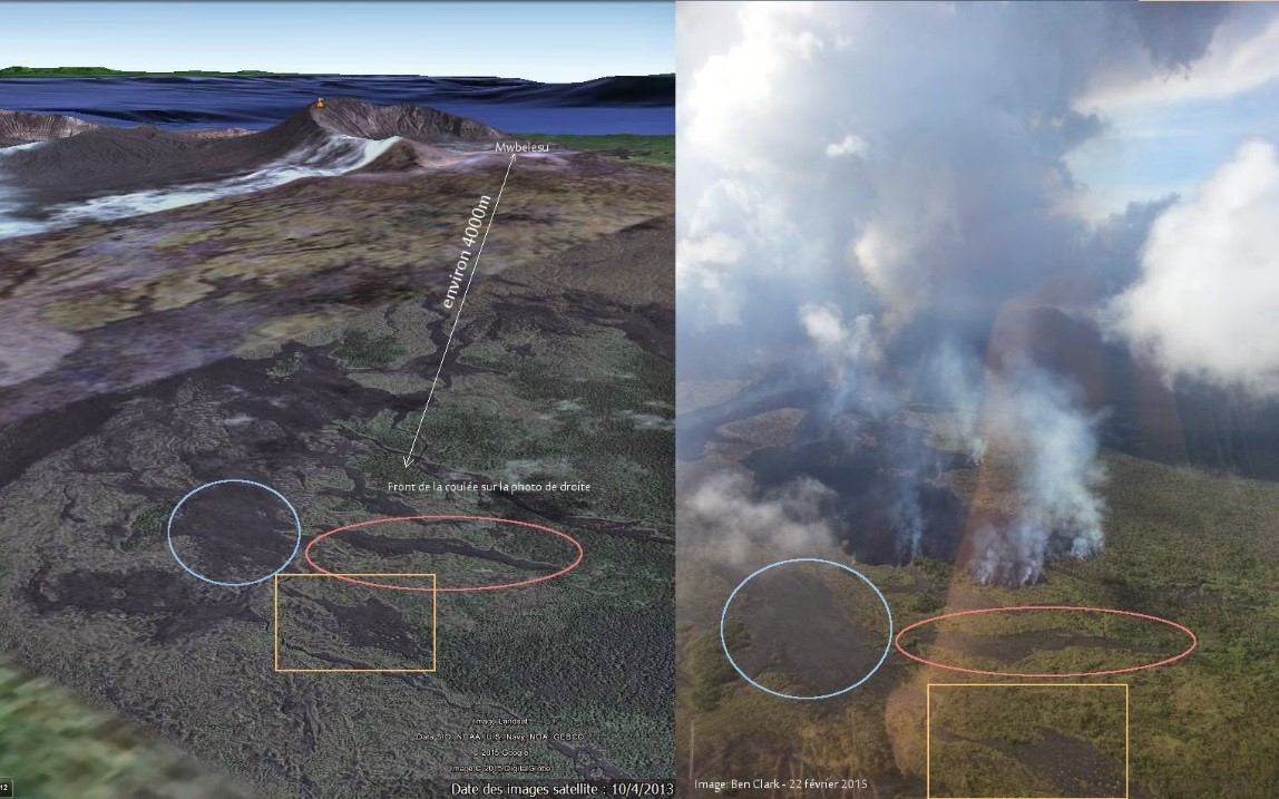 |
Figure 32. The new lava flow at Ambrym was photographed by Ben Clark on 22 February 2015 (right), here compared with a Google Earth image from 2013 (left). Image and annotations courtesy of Culture Volcan. |
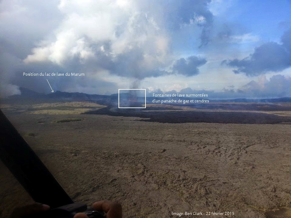 |
Figure 33. Lava fountains on Ambrym volcano, 22 February 2015. Marum lava lake in upper left, lava fountains and ash plume inside white box. Photo courtesy Ben Clark, annotations courtesy Culture Volcan. |
MODVOLC data from 21 February shows a large thermal anomaly in the SE quadrant of the large crater which was no longer visible by 23 February. This could be from vegetation fires associated with the new lava flow, and suggests that it only flowed actively for ~ 2 days. Culture Volcan reported that the Wellington VAAC had noted a 2-km-high ash plume on 21 February.
On 2 March 2015, VGO reported that activity at Ambrym had slightly decreased but remained elevated, and the Alert Level was lowered to 2. By 25 April 2015 Satellite imagery showed only a steam-and-ash plume drifting W from the two active craters (figure 34).
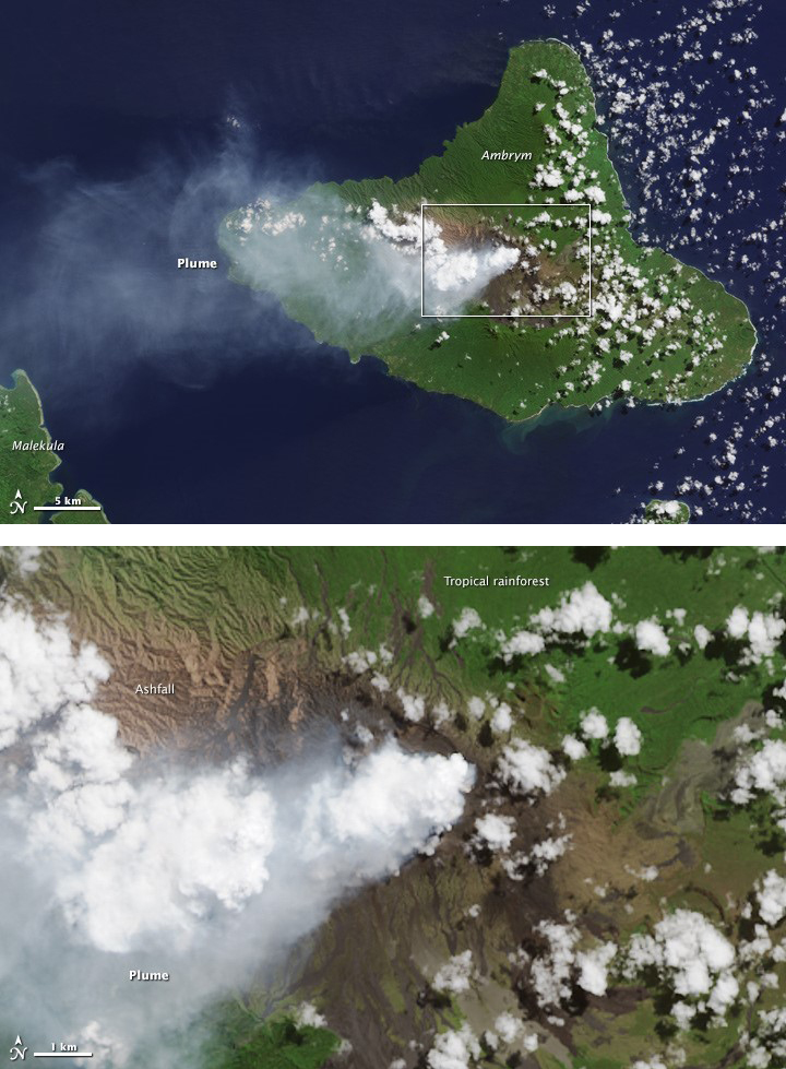 |
Figure 34. NASA Earth Observatory acquired this image on 25 April 2015 from the Operational Land Imager (OLI) on Landsat 8. The top image shows the plume extending over the South Pacific Ocean toward Malekula. The bottom image shows a close up of the plume over two craters Benbow (left) and Marum (right). Image by Jesse Allen, caption by Kathryn Hansen. Courtesy NASA Earth Observatory. |
Geological Summary. Ambrym, a large basaltic volcano with a 12-km-wide caldera, is one of the most active volcanoes of the New Hebrides Arc. A thick, almost exclusively pyroclastic sequence, initially dacitic then basaltic, overlies lava flows of a pre-caldera shield volcano. The caldera was formed during a major Plinian eruption with dacitic pyroclastic flows about 1,900 years ago. Post-caldera eruptions, primarily from Marum and Benbow cones, have partially filled the caldera floor and produced lava flows that ponded on the floor or overflowed through gaps in the caldera rim. Post-caldera eruptions have also formed a series of scoria cones and maars along a fissure system oriented ENE-WSW. Eruptions have apparently occurred almost yearly during historical time from cones within the caldera or from flank vents. However, from 1850 to 1950, reporting was mostly limited to extra-caldera eruptions that would have affected local populations.
Information Contacts: Vanuatu Geohazards Observatory (VGO), Geo-Hazards office, Vanuatu Meteorology and Geo-Hazards Department (URL: http://www.vmgd.gov.vu/vmgd/); Wellington Volcanic Ash Advisory Centre (VAAC), Meteorological Service of New Zealand Ltd (MetService), PO Box 722, Wellington, New Zealand (URL: http://vaac.metservice.com/); Volcano Discovery (URL: https://www.volcano-adventures.com/photos/vanuatu/tour/2014/marum-bembow-lavalakes.html); NASA Global Sufur Dioxide Monitoring Page (URL: https://so2.gsfc.nasa.gov/); Culture Volcan: Journal d'un volcanophile (URL: http://laculturevolcan.blogspot.fr/); Hawai'i Institute of Geophysics and Planetology (HIGP), MODVOLC Thermal Alerts System, School of Ocean and Earth Science and Technology (SOEST), Univ. of Hawai'i, 2525 Correa Road, Honolulu, HI 96822, USA (URL: http://modis.higp.hawaii.edu/); NASA Earth Observatory, EOS Project Science Office, NASA Goddard Space Flight Center, Goddard, Maryland, USA (URL: http://earthobservatory.nasa.gov/).