Report on Deception Island (Antarctica) — June 2015
Bulletin of the Global Volcanism Network, vol. 40, no. 6 (June 2015)
Managing Editor: Edward Venzke.
Deception Island (Antarctica) Sustained deformation and large increase in seismic activity during 2014-12015
Please cite this report as:
Global Volcanism Program, 2015. Report on Deception Island (Antarctica) (Venzke, E., ed.). Bulletin of the Global Volcanism Network, 40:6. Smithsonian Institution. https://doi.org/10.5479/si.GVP.BGVN201506-390030
Deception Island
Antarctica
62.9567°S, 60.6367°W; summit elev. 602 m
All times are local (unless otherwise noted)
Since 1989, the Spanish Antarctic Program has done monitoring at Deception during austral summers. This work is carried out by researchers from University of Granada and University of Cádiz, Spain, in collaboration with other institutions. There was no recorded seismicity, deformation, or soil temperature flux during late 2008-early 2009 (BGVN 34:03). However, the 2014-15 survey noted sustained deformation and increased seismicity.
The instrumental network was basically the same in use since 2008 (figure 22). Researchers deployed a temporary seismic network made up of five three-component, short-period seismic stations and a small-aperture seismic array (Carmona et al., 2014).
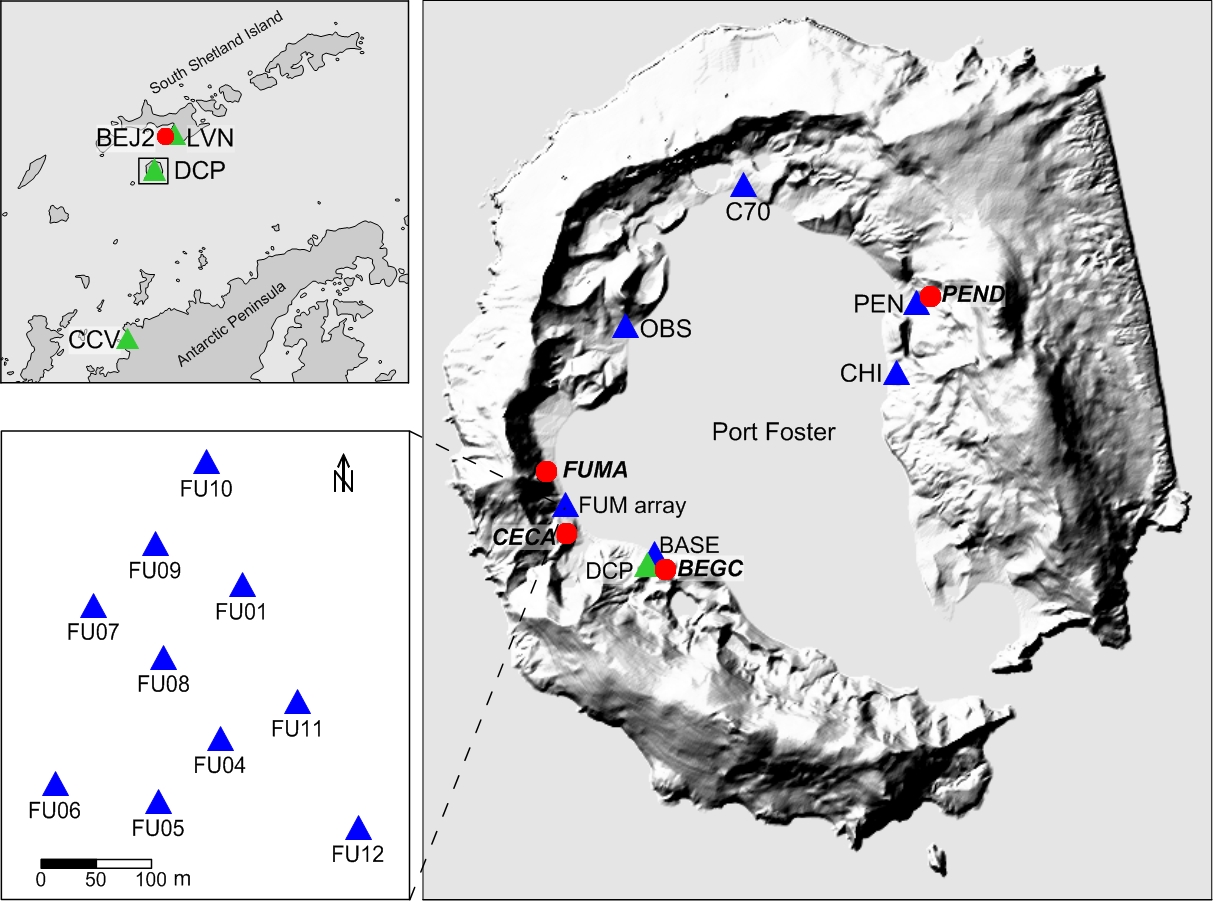 |
Figure 22. Locations of the instruments of the monitoring network at Deception Island and surroundings. Green triangles are permanent seismometers; blue triangles are temporary seismometers; red dots indicate deformation & temperature measurements. Courtesy of the Spanish Antarctic Program. |
Data was transmitted to the "Gabriel de Castilla" Spanish Base where it could be analyzed in real time. These instruments usually operate between early December and late February. The researchers also ran three permanent broadband seismic stations at Livingston Island, Deception Island, and Cierva Cove, which have been operating continuously since February 2008. Deformation measurements were obtained with three GPS stations and an EDM, together with Wi-Fi transmission and real-time analysis (Peci et al., 2012). A temperature sensor was deployed at CECA (Cerro Caliente).
Variations in distance between GPS stations since 2013 revealed a steady increase in distance of ~5 cm/year (figure 23). The 2014-2015 survey shows an accumulated deformation of 10 cm. The pattern of deformation suggests inflation in response to a pressure source under Port Foster.
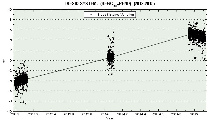 |
Figure 23. Variations in distance between GPS stations BEGC and PEND from 2013 to 2015. Courtesy of the Spanish Antarctic Program. |
The seismic activity between 1994 and 2011 has been described by Ibáñez et al. (2000, 2003a) and Carmona et al. (2012). Two types of seismicity are generally detected. Tectonic and volcano-tectonic (VT) earthquakes are characterized by wide-band signals related to the occurrence of fractures in the medium. Long-period (LP) seismicity is characterized by narrow-band signals that include both isolated events and volcanic tremor, and are often interpreted as a consequence of interactions between solids and hot fluids in volcano environments. Between the 1999 VT earthquake series (Ibáñez et al., 2003b) and 2011, the seismic activity has been relatively quiet, with occasional peaks of activity, for example during the 2003-2004 survey (Carmona et al., 2012). This trend continued until the 2012-2013 survey, when a larger number of both LP and VT events were detected. (figure 24).
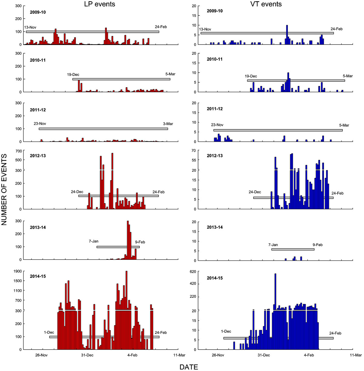 |
Figure 24. Comparison of the daily number of seismic events (long-period at left, volcano-tectonic at right) recorded during summer surveys since 2009-2010. The gray bands indicate the duration of the survey. Note the change in the scale of the y-axis during 2012-2013 and 2014-2015. Courtesy of the Spanish Antarctic Program. |
During the 2013-2014 survey seismicity seemed to be quite low, but the data covered barely one month. During the 2014-2015 survey, seismic activity was very intense (figure 24). The total number of events recorded was an order of magnitude larger than in previous years, and by far the most active survey since the unrest in 1999. The high level may be related to the deformation previously noted. LP seismicity was detected mainly at the FUM and OBS stations, on the western shores of Port Foster. The array analysis suggests that the source of this seismicity lies on the western side of the island.
Tectonic and volcano-tectonic earthquakes were common, but most were too small to be recorded adequately over the entire network, so could not be located. One cluster was centered SE of Livingston Island, which was active during the whole survey. Another cluster was located SW of Deception Island, with the remainder at distances of 5-20 km.
The closest events occurred during the last weeks of the survey, which led researchers to recommend a change in the hazard status. The Spanish Polar Committee raised the volcanic alert level to yellow for a few days in February 2015.
References: Berrocoso, M., Fernández-Ros, A., Ramírez, M. A., Salamanca, J. M., Torrecillas, C., Pérez-Peña, A., Páez, R., García-García, A., Jiménez-Teja, Y., García-García, F., Soto, R., Gárate, J., Martín-Dávila, J., Sánchez-Arzola, A., De Gil, A., Fernández-Prada, J. A. & Jigena, B. (2008).
Geodetic research on Deception Island and its environment (South Shetland Islands, Bransfield Sea and Antarctic Peninsula) during Spanish Antarctic campaigns (1987-2007), in: Geodetic and Geophysical Observations in Antarctica, A. Capra, R. Dietrich (eds.), pp. 97-123.
Carmona, E., Almendros, J., Serrano, I., Stich, D., Ibáñez, J. M. (2012). Results of seismic monitoring surveys of Deception Island volcano, Antarctica, from 1999-2011, Antarctic Science, 24, 1-15, doi:10.1017/S0954102012000314.
Carmona, E., Almendros, J., Martín, R., Cortés, G., Alguacil, G., Moreno, J., Martín, B., Martos, A.,Serrano, I., Stich, D., Ibáñez, J. M. (2014). Advances in seismic monitoring at Deception Island volcano (Antarctica) since the International Polar Year, Annals of Geophysics 57(3), SS0321, doi:10.4401/ag-6378.
Ibanez, J. M., Del Pezzo, E., Almendros, J., La Rocca, M., Alguacil, G., Ortiz, R., Garcia, A. (2000). Seismovolcanic signals at Deception Island volcano, Antarctica: wave field analysis and source modeling, J. Geophys. Res., 105, 13905-13931.
Ibáñez, J. M., Almendros, J., Carmona, E., Martínez-Arévalo, C. & Abril, M. (2003a). The recent seismo-volcanic activity at Deception Island volcano. Deep-Sea Research II, 50, 1611-1629.
Ibanez, J. M., Carmona, E., Almendros, J., Saccorotti, G., Del Pezzo, E., Abril, M., Ortiz, R. (2003b). The 1998-1999 seismic series at Deception Island volcano, Antarctica, J. Volcan. Geotherm. Res., 128, 65-88.
Peci, L. M., Berrocoso, M., Páez, R., Fernández-Ros, A., de Gil, A. (2012). IESID: Automatic system for monitoring ground deformation on the Deception Island volcano (Antarctica). Computers & Geosciences, 48, 126-133.
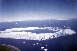
Geological Summary. Ring-shaped Deception Island, at the SW end of the South Shetland Islands, NE of Graham Land Peninsula, was constructed along the axis of the Bransfield Rift spreading center. A narrow passageway named Neptunes Bellows provides an entrance to a natural harbor within the 8.5 x 10 km caldera that was utilized as an Antarctic whaling station. Numerous vents along ring fractures circling the low 14-km-wide island have been reported active for more than 200 years. Maars line the shores of 190-m-deep Port Foster caldera bay. Among the largest of these maars is 1-km-wide Whalers Bay, at the entrance to the harbor. Eruptions during the past 8,700 years have been dated from ash layers in lake sediments on the Antarctic Peninsula and neighboring islands.
Information Contacts: Javier Almendros, Enrique Carmona, Vanessa Jiménez, Alejandro Díaz, and Francisco Lorenzo, Instituto Andaluz de Geofísica, University of Granada, Spain; Manuel Berrocoso, Amós de Gil, Alberto Fernández-Ros, and Belén Rosado, University of Cádiz, Spain.