Report on Ketoi (Russia) — September 2015
Bulletin of the Global Volcanism Network, vol. 40, no. 9 (September 2015)
Managing Editor: Edward Venzke.
Research and preparation by Robert Andrews.
Ketoi (Russia) Thermal anomalies and large gas-and-steam emissions during July-August 2013
Please cite this report as:
Global Volcanism Program, 2015. Report on Ketoi (Russia) (Venzke, E., ed.). Bulletin of the Global Volcanism Network, 40:9. Smithsonian Institution. https://doi.org/10.5479/si.GVP.BGVN201509-290200
Ketoi
Russia
47.35°N, 152.475°E; summit elev. 1172 m
All times are local (unless otherwise noted)
Pallas Peak, the large cone in the caldera on Ketoi Island in the central Kurile Islands, last erupted in September 1960. Scientists on monitoring flights during the 1980's sometimes observed fumarolic activity on the outer N slope of Pallas Peak (SEAN 06:12, 12:04, and 14:03), and the Sakhalin Volcanic Eruption Response Team (SVERT) reported increased fumarolic activity based on satellite imagery analysis on 4 May 2010.
Gas-and-steam emissions from Pallas Peak were again observed in satellite imagery during 16-17 January 2013. On 25 and 29-30 July 2013 a thermal anomaly on Pallas Peak was detected in satellite data. Gas-and-steam emissions were also observed drifting 100 km NW on 25 July. On 27 July gas-and-steam emissions possibly containing ash drifted 45 km SSE. Though this eruption was uncertain, SVERT raised the alert level to Yellow.
Additional gas-and-steam emissions were observed on 29 July, and possibly again on 31 July, 4 August, and 9 August 2013. Thermal anomalies were identified during 5-7, 9, possibly 10-11, 12, and possibly 26 August. After another possible thermal anomaly on 1 September there were no further reports of anomalous activity by SVERT.
A copyrighted photo taken by Joseph Szeles from a ship on 15 January 2014 showed a small fumarolic plume rising from the caldera.
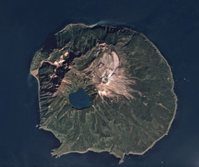
Geological Summary. The circular 10-km-wide Ketoi island, which rises across the 19-km-wide Diana Strait from Simushir Island, hosts of one of the most complex volcanic structures of the Kuril Islands. The rim of a 5-km-wide Pleistocene caldera is exposed only on the NE side. A younger stratovolcano forming the NW part of the island is cut by a horst-and-graben structure containing two solfatara fields. A 1.5-km-wide freshwater lake fills an explosion crater in the center of the island. Pallas Peak, a large andesitic cone in the NE part of the caldera, is truncated by a 550-m-wide crater containing a brilliantly colored turquoise crater lake. Lava flows from Pallas Peak overtop the caldera rim and descend nearly 5 km to the SE coast. The first historical eruption of Pallas Peak, during 1843-46, was its largest.
Information Contacts: Sakhalin Volcanic Eruption Response Team (SVERT), Institute of Marine Geology and Geophysics, Far Eastern Branch, Russian Academy of Science, Nauki st., 1B, Yuzhno-Sakhalinsk, Russia, 693022 (URL: http://www.imgg.ru/en/, http://www.imgg.ru/ru/svert/reports); Joseph Szeles, Brussels, Belgium (URL: https://www.flickr.com/photos/jo_sze/11962181276/)