Report on Poas (Costa Rica) — November 2015
Bulletin of the Global Volcanism Network, vol. 40, no. 11 (November 2015)
Managing Editor: Edward Venzke.
Edited by A. Elizabeth Crafford.
Poas (Costa Rica) Numerous phreatic explosions from the lake into mid-October 2014
Please cite this report as:
Global Volcanism Program, 2015. Report on Poas (Costa Rica) (Crafford, A.E., and Venzke, E., eds.). Bulletin of the Global Volcanism Network, 40:11. Smithsonian Institution. https://doi.org/10.5479/si.GVP.BGVN201511-345040
Poas
Costa Rica
10.2°N, 84.233°W; summit elev. 2697 m
All times are local (unless otherwise noted)
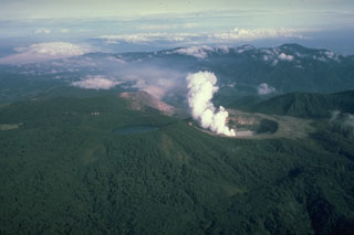
Activity at Costa Rica's Poás Volcano, located about 35 km NW of the country's capital, San Jose, is characterized by intermittent phreatic explosions from its "ultra-acid" Laguna Caliente that cause geyser-like eruptions of crater lake water and sediment. Scientists from Observatorio Vulcanológico y Sismológico de Costa Rica, Universidad Nacional (OVSICORI-UNA) have been regularly monitoring the volcano for over 40 years, measuring numerous characteristics including: seismicity, geochemistry, temperature variations of fumaroles, SO2 and CO2 emissions around the crater, deformation, and the geochemistry, temperature and pH variations of the lake. Many details of that data are discussed in their monthly reports; highlights from the reports for 2014 are summarized here.
OVSICORI-UNA scientists have observed that Poás has exhibited, over the last half century, cycles of phreatic eruptions that last for approximately 6-10 years before a period of relative calm. These phreatic eruptions are characterized by sudden explosions from the lake as a result of the abrupt expansion of steam and magmatic gases that accumulate in the underlying hydrothermal system. The eruptions eject superheated steam and gas, molten sulfur, lake sediments, and altered rock fragments around the lake. Most of the explosions are small, reaching heights above the surface of the lake of tens of meters. However, some reach 100-400 m and spread debris around the edges of the crater. The release of steam and magmatic gases from beneath the lake also causes vigorous convection in the lake, and frequent color changes of the lake from gray-green to bright turquoise related to changing redox conditions in the lake. The lake level shows annual changes on the order of 3-5 m caused by variations in hydrothermal activity and seasonal weather. Lake chemistry, pH and temperature show complex interrelated variations. The current activity cycle began in March 2005 with strong underwater fumarolic activity, and the start of phreatic eruptions in March 2006.
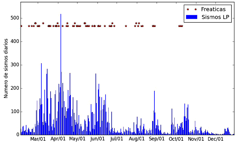
Large phreatic explosions occurred several times in 2014; the largest explosions occurred in February, May, June, August, and October. Seismic activity peaked in April with over 500 daily seismic events; periods of heightened activity with greater than 100 daily events occurred several times during the year, decreasing in late October to a few tens of events per day. Fumarole temperatures were highly variable, fluctuating every few months between 200 and 600°C. The lake level dropped several meters in the first half of the year with an accompanying increase in temperature and drop in pH. These trends reversed for the second half of the year. Decreased underwater emissions in December caused a bright turquoise lake color and less convective and explosive activity at year's end.
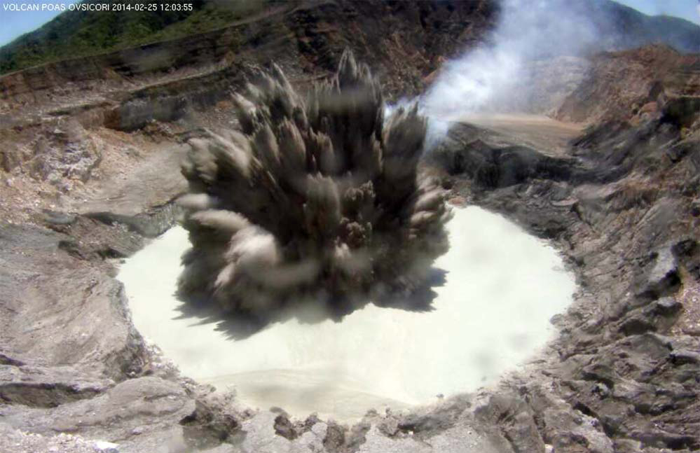
Phreatic eruptions. Large explosions on 24 and 25 February ejected water, steam, gas, sediment, and rock fragments over 400 m above the lake's surface; most of the material fell back into the lake, but some landed on the W, N, and E parts of the crater walls (figure 105). In March there were 14 small eruptions recorded, with the biggest occurring on 30 March, but many other even smaller events were observed by the webcam as bubbles bursting on the surface of the lake. In spite of a large increase in seismicity in April, only 12 small phreatic explosions were recorded. Fifteen events occurred in the lake during May. The smaller explosions rose to heights of 10-30 meters, but eruptions that exceeded 100 meters high occurred on 3, 13, 19, and 24 May (>300 m).
In the last days of May 2014 several interesting events were observed at the crater. On 28 May at night, the MULTIGAS detection system that monitors the composition of volcanic gases in real time recorded saturation signals of several gas sensors, indicating a significant release of magmatic gases into the atmosphere. On the morning of 29 May around 0717 residents in Pueblo Nuevo de Zarcero (9 km NNW) reported observing a vigorous plume of gas and steam rising above the summit. That same morning OVSICORI-UNA volcanologists were doing routine work in the crater and witnessed four small phreatic eruptions no more than 50 m high and strong degassing from the dome on the south side of the lake (also sometimes referred to as a "cryptodome" by OVSICORI-UNA).
Two large explosions and eight smaller ones were recorded in June. The largest, on 1 June at 1954, was not discovered until the next day. Poás Volcano National Park Staff reported abundant material deposited around the edge of the lake after a routine inspection on 2 June. Rock fragments ejected by this explosion hit the permanent OVSICORI-UNA MULTIGAS system, damaging the solar panel and breaking the transmitting antenna. On 20 June 2014 at 1008 another eruption produced a column that reached approximately 200 m above the lake surface (figure 106).
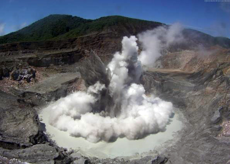 |
Figure 106. Phreatic eruption at Poás on 20 June 2014 at 1008 local time captured by the web camera of OVSICORI-UNA. Courtesy of OVSICORI-UNA (June 2014, Estado de los Volcanes de Costa Rica). |
In July, there were frequent small eruptions (averaging two per day) that reached heights 30-50 m above the lake, and only one moderate eruption, on 31 July. The biggest eruption recorded during August occurred on 27 August and sent a column of debris over 200 meters high. This eruption consisted of four separate explosions that occurred within a short time interval.
Two large eruptions, on 8 and 13 October, were the last explosions of the year. They sent material over 250 m into the air, and caused ashfall on the lookout area visitor's center. The second explosion also sent caustic plumes downwind that led to the evacuation of the National Park and restricted access for 10 days. The eruption of 8 October was the largest of the year, while the eruption of 13 October was the most complex as it consisted of at least four discrete events in less than two minutes. Following these explosions, there was a decrease in temperature of both the fumaroles and the lake, a considerable reduction in seismic activity, a marked decrease in gas flow in the fumaroles of the dome, and a noticeable reduction in the convective activity of underwater fumaroles in the lake.
Seismicity. Seismicity varied significantly throughout 2014 (figure 107). At the beginning of the year the number of daily events were similar to those from the end of 2013, less than 50/day. After the large explosions of 24-25 February, seismicity increased to over 100 events per day, and peaked on 5 April with more than 500 daily events. An unusual seismic swarm E of the active crater was recorded on 17 May. The largest earthquake registered was a M 1.8, and was 6 km deep. The numbers of seismic events decreased in May, and spiked up again in June to between 100 and 200 daily events before decreasing to less than 30 events per day in July.
Seismic values increased slightly toward the end of August, but dropped to very low levels in September. The seismic activity increased almost exponentially between early and mid-October from an average of less than 10 events per day (early October) to more than 100 events per day (figure 107), and then fell rapidly again towards the end of the month. This last spike of seismicity in 2014 occurred between 6 and 13 October when three moderate eruptions were recorded. Seismic activity at the volcano declined significantly after the last major eruption on 13 October. After this, several medium-amplitude tremors were recorded, along with a few low-frequency (LF) events with larger than normal amplitudes. Both the large and middle amplitude earthquakes were reported with decreasing frequency during November and December.
Fumarole temperatures. "El domo" is a domed area on the S side of the crater lake composed of highly altered rocks. It is a tuff ring formed during phreatomagmatic activity between 1953 and 1955. The dome has been a site of persistent fumarolic degassing for the last 200 years.
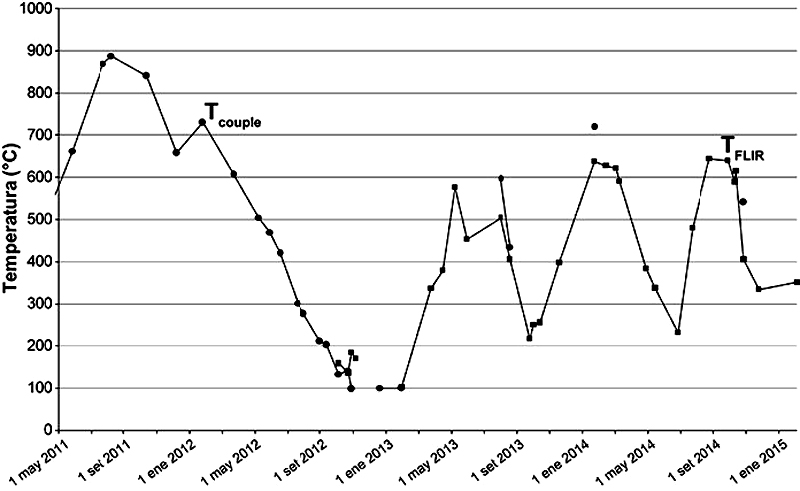
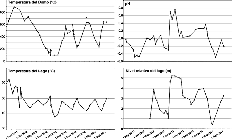
Fumarole temperatures gradually increased after May 2008, reaching maximum values of around 900°C between July and October 2011 (figure 108). This was followed by a decrease to values around 100°C between late 2012 and early 2013. From 2013 through 2014 fumarole temperatures recorded sharp fluctuations, but always remained above 200°C.
At the beginning of 2014, the temperature of the fumaroles were high, around 600°C, and decreased to around 200°C by the end of June. Temperatures increased again in July 2014 to values close to 500°C. Incandescence around the dome from these high temperatures was observed from 3 July to mid-August 2014 in night images from the webcam.
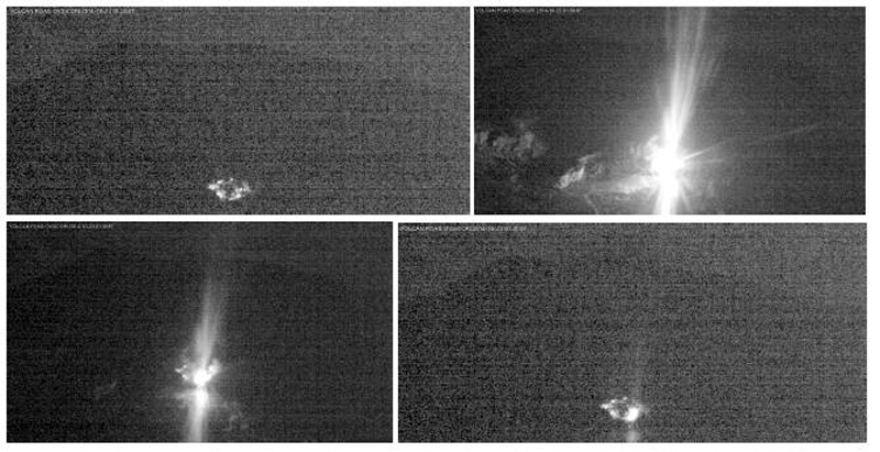
From 23 October through the end of 2014, the dome fumaroles exhibited a drastic decrease in temperature and gas flow. This change was preceded by a sharp and sudden release of high temperature magmatic gases in a combustion event that generated a flash of light (figure 109) in the N section of the dome near the surface of the lake. This flash of light lasted for 2:24 minutes and was the result of spontaneous combustion of the magmatic gases at high temperatures in contact with atmospheric oxygen, generating exothermic chemical reactions that released energy as heat and light. After this event, the flow of gases through the dome decreased substantially compared with the observed flows earlier in the year.
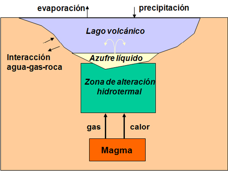
Lake convection, temperature, level and pH. A schematic cross section of the lake by OVSICORI-UNA scientists shows the relationship between the lake and the underlying magmatic-hydrothermal system (figure 110). This model explains the dramatic phreatic explosions, and extreme temperature and pH variations that are common in the lake from continuously occurring water-gas-rock interactions.
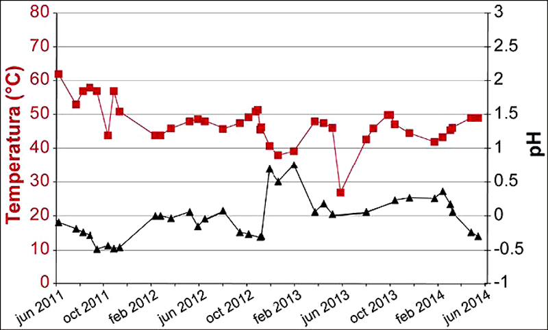
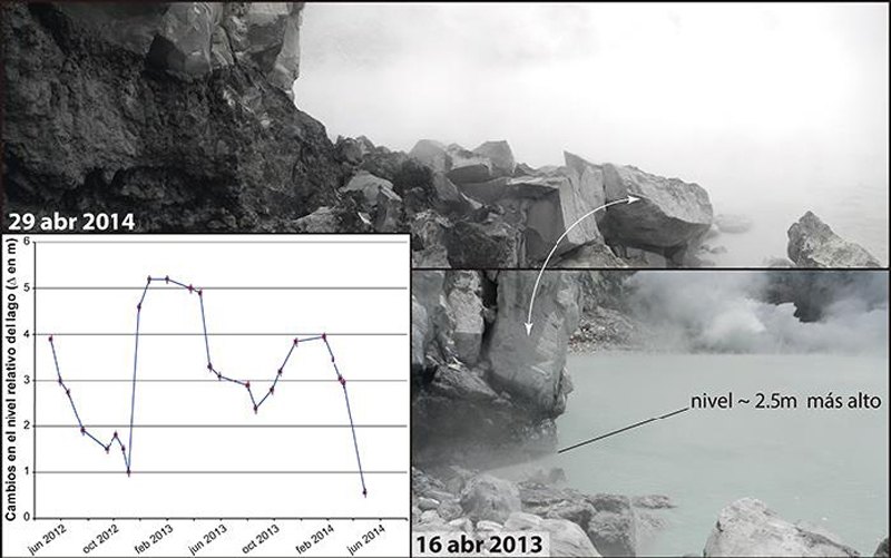
Laguna Caliente has been recognized as having one of the lowest pH's of any lake in the world; its pH dropped during June and July 2014 to near-record low levels not seen since 2012 (figure 111). Significant variations in the lake level occur over time as well. The lake level dropped over 3 m between January and April 2014 (figure 112). This very low level was possibly due to increased heat under the lake (figure 110), which would increase the evaporation rate and explain the increase in temperature and acidity (figure 111). In addition, the possible increase in gas supply could explain the frequent small phreatic eruptions in April (figure 107).
On 4 May, a sudden bubbling and strong convection was observed in the central part of the lake. The abrupt rise of fluid brought a substantial amount of viscous molten sulfur to the surface of the lake. The molten sulfur temporarily covered almost the entire lake surface. This sulfur rise was preceded by short-duration tremors a few days earlier, on 26 April. Several additional times during the year molten sulfur was observed on the surface of the lake. The active convection of the lake was imaged by thermal camera on 27 June and revealed numerous convection cells and molten sulfur (figure 113).
The lake also changes color as a function of convective activity. The color change is indicative of a change in the redox conditions of the acidic water such that the iron is stabilized in its reduced form Fe2+ in acidic waters that are rich in sulfur and colloidal silica, which in turn suggests a significant decrease in the injection of sulfur dioxide, SO2, into the lake.
In July, the lake showed signs of another significant increase in acidity as a result of an injection of fresh magmatic fluids into the hydrothermal system that feeds the lake and the fumaroles at the dome. In particular, on 13 July a large amount of molten sulfur, evaporation, and vigorous convection with multiple cells distributed over the lake surface was observed (figure 114).
In September the lake level rose about 50 cm due to high rainfall typical of the rainy season (figure 115). In spite of this, the temperature and acidity of the lake remained high at 50°C and pH = -0.22 (figure 115).
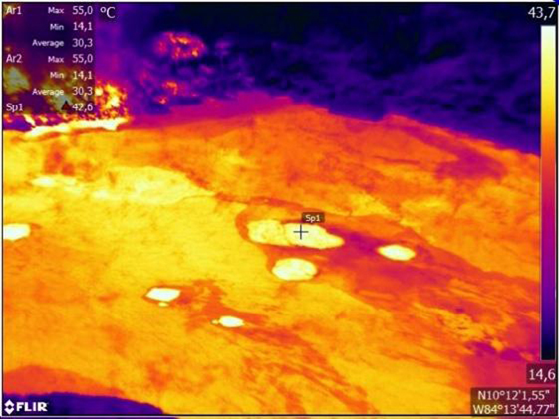
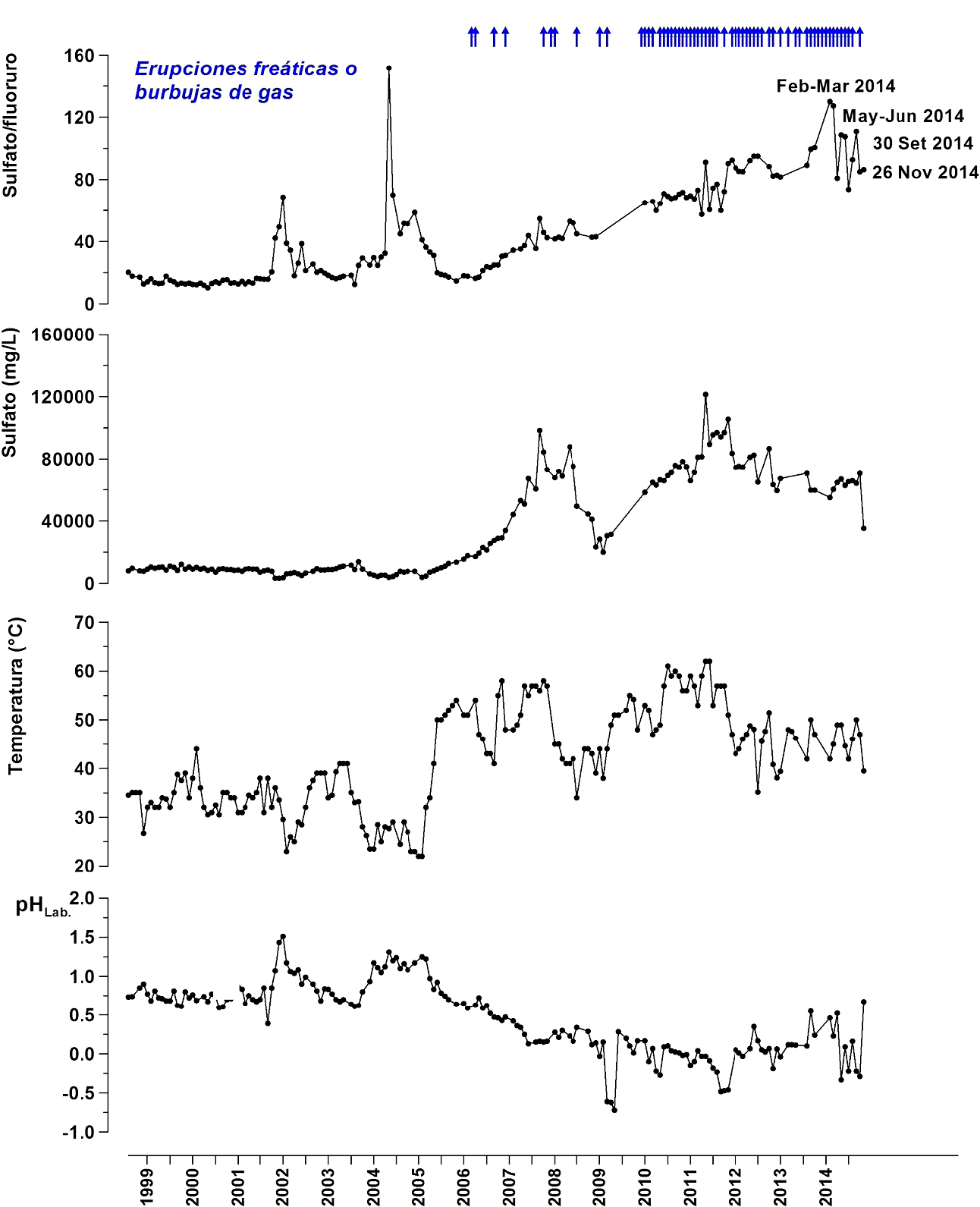
By the end of October, activity in the lake had dropped significantly, with fewer eruptions, less elemental sulfur observed on the surface of the lake, a greener color of the lake indicative of less convection, and a drop in the lake's temperature (figure 116, third graph from top). A remote lake temperature measurement was performed on 11 November with FLIR infrared thermographer T650sc provided to OVSICORI-UNA by Termogram S.A. for field testing. The apparent maximum temperature in the lake was 43°C at a distance from the lake of approximately 400 m, indicating a significant drop in temperature from October (figure 116, third graph). In late November, a significant decrease was also observed in acidity, temperature, and injection of sulfur-rich magmatic gases as compared with previous months (figure 116).
Long-term changes in the proportions of dissolved ions (sulfate/fluoride) derived from the hydrolysis of volatile magmatic components (SO2 and HF), have shown a systematic increase in the amount of sulfur gases that are injected from the magmatic-hydrothermal system into the lake and fumaroles of the dome since 2006 (figure 116, top graph). In 2014, the sulfate/fluoride ratios peaked at values greater than 100 in periods during the times of more energetic phreatic eruptions (February-March 2014, May-June 2014, and September-October 2014) (figure 116, top graph).
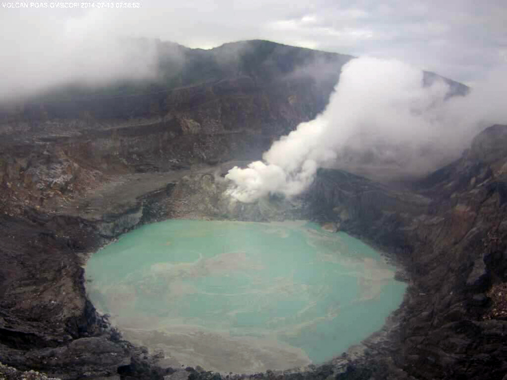
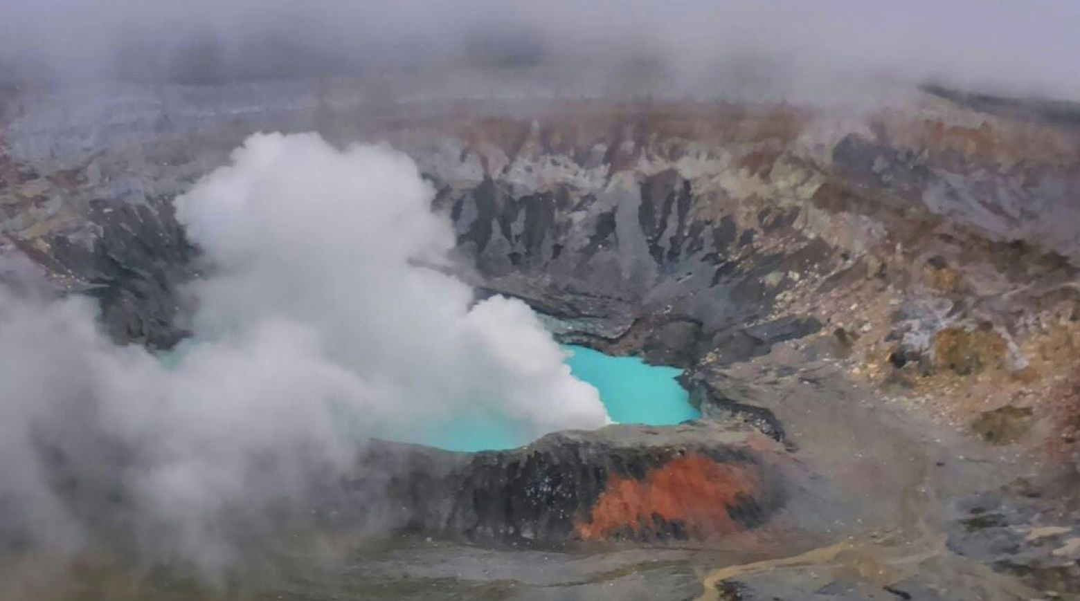
Between late October and December, the lake showed a dramatic and unusual color change from greenish gray to bright turquoise indicating a marked decrease in the rate of emission of volatile magmatic gases through the underwater fumaroles (figure 117). Between November and December the lake volume also increased from high amounts of rainfall. The combination of iron ions, sulfur, and colloidal silica suspended in the water results in the bright turquoise color.
Geological Summary. The broad vegetated edifice of Poás, one of the most active volcanoes of Costa Rica, contains three craters along a N-S line. The frequently visited multi-hued summit crater lakes of the basaltic-to-dacitic volcano are easily accessible by vehicle from the nearby capital city of San José. A N-S-trending fissure cutting the complex stratovolcano extends to the lower N flank, where it has produced the Congo stratovolcano and several lake-filled maars. The southernmost of the two summit crater lakes, Botos, last erupted about 7,500 years ago. The more prominent geothermally heated northern lake, Laguna Caliente, is one of the world's most acidic natural lakes, with a pH of near zero. It has been the site of frequent phreatic and phreatomagmatic eruptions since an eruption was reported in 1828. Eruptions often include geyser-like ejections of crater-lake water.
Information Contacts: Observatorio Vulcanologico Sismologica de Costa Rica-Universidad Nacional (OVSICORI-UNA), Apartado 86-3000, Heredia, Costa Rica (URL: http://www.ovsicori.una.ac.cr/).

