Report on Copahue (Chile-Argentina) — March 2016

Bulletin of the Global Volcanism Network, vol. 41, no. 3 (March 2016)
Managing Editor: Edward Venzke.
Research and preparation by Paul Berger.
Copahue (Chile-Argentina) Eruptions during July-December 2014 and September 2015 into 2016
Please cite this report as:
Global Volcanism Program, 2016. Report on Copahue (Chile-Argentina) (Venzke, E., ed.). Bulletin of the Global Volcanism Network, 41:3. Smithsonian Institution. https://doi.org/10.5479/si.GVP.BGVN201603-357090
Copahue
Chile-Argentina
37.856°S, 71.183°W; summit elev. 2953 m
All times are local (unless otherwise noted)
After 12 years of passive degassing, Copahue became more active in 2012-2013 with an increase in seismicity, minor ash explosions (of which at least some were phreatic or phreatomagmatic), and increased fumarolic activity from the crater lake (BGVN 38:09). Except where otherwise noted, observations were provided by the Observatorio Volcanológico de los Andes del Sur-Servicio Nacional de Geologia y Mineria (OVDAS-SERNAGEOMIN); the Buenos Aires Volcanic Ash Advisory Center (VAAC) also provided frequent reports of ash plumes.
This report covers the period from January 2014 to January 2016. Small explosions were recorded on 10 December 2013, the final activity of an eruption that began in December 2012; the volcano was quiet in subsequent months. Seismic unrest and elevated sulfur dioxide emissions began again in March 2014. A phreatic explosion on 4 July was followed by earthquake swarms and eventually significant ash explosions during 6 October-2 December 2014. Eruptive activity resumed around 20 September 2015 and was continuing as of late January 2016.
Activity during March-December 2014. A gradual increase of volcanic tremor was detected starting at 0230 on 20 March 2014; from 0230 to 1100 the signal fluctuated and intense periods lasted up to 3 hours. Cameras showed minimal surface activity, while SO2 concentrations increased. The Alert Level was raised to Orange (second highest level), and residents and visitors were prohibited within a 3-km radius of the active crater. During 21-24 March, gas plumes rose as high as 500 m and drifted E. Seismicity continued to increase.
Cameras installed around the volcano recorded white gas plumes rising 100-600 m above the crater during 25-29 March; clouds prevented observations on 30 March. SO2 measurements in metric tons per day (t/d) were 270 on 26 March, 1,400 on 27 March, 2,000 on 28 March, 1,400 on 29 March, and 920 on 30 March. On 4 April 2014 activity continued to fluctuate at an elevated level, but not at a level that would suggest an impending eruption; the Alert Level was lowered to Yellow.
A phreatic explosion on 4 July deposited bombs (less than 12 cm in diameter), lapilli (less than 4 cm), ash, and gray clay smelling strongly of sulfuric acid along the E flank of the crater. During an overflight on 7 July, OVDAS-SERNAGEOMIN officials observed the deposit and measured a moderate amount of SO2 emissions (average 4,000 t/d), a relatively low water level in the crater, and low fumarole temperatures within El Agrio crater. DOAS stations had measured up to 18,000 t/d of SO2 on the day of the explosion. An anomalous tremor signal was detected at 0823 on 5 July that was associated with an explosion from the crater; a microphone installation 13 km E also detected an acoustic signal. The explosion generated a plume 1,000 m above the crater.
On 14 September 2014 there was seismicity, with a seismic swarm of 389 long-period earthquakes; epicenters were within the crater area and hypocenters were at depths less than 3 km. Web cameras captured a persistent vapor plume that reached ~250 m above the crater and drifted ~700 m ENE. On 26 September a special volcanic activity report issued by OVDAS-SERNAGEOMIN noted a seismic swarm of 140 long-period events. Cameras recorded increased emissions; mostly white plumes with some ash rose 200-500 m and drifted SE. The report also noted that swarms had been recorded in late July and during 1-16 September.
The Buenos Aires VAAC reported that during 6-7 October, satellite images detected diffuse steam-and-gas emissions with a small amount of ash that originated from near the summit. Two explosions from the crater on 11 October, reported by OVDAS-SERNAGEOMIN, generated dark gray ash plumes that rose as high as 3.6 km above the crater. Some minor explosions were detected after the second explosion. Incandescence in the vicinity of the crater was observed at night. The Alert Level was raised to Orange. Cameras recorded dark gray ash plumes rising to a maximum height of 1.9 km and drifting 35 km NE on 12 October, 2.2 km and drifting E on 13 October, and 0.4 km and drifting E on 14 October. Minor explosions continued to be detected.
On 15 October gray ash plumes rose 300 m above the crater and four explosions were recorded. Plumes on 17 October were generally white and rose 100 m; no explosions were detected. Seismicity was low on 18 October. On 19 October, six explosions associated with ash emissions were recorded, plumes rose 300 m, and incandescence from the crater was seen in the evening. The network recorded 12 explosions with associated ash emissions the next day. During 20-21 October, plumes rose 200 m (figure 16), and crater incandescence at night was noted. Seismicity continued decreasing on 24 October, and emissions had become more diffuse with only minute amounts of tephra in some plumes. A small mud lake had also formed in the crater. The Alert Level was reduced to Yellow.
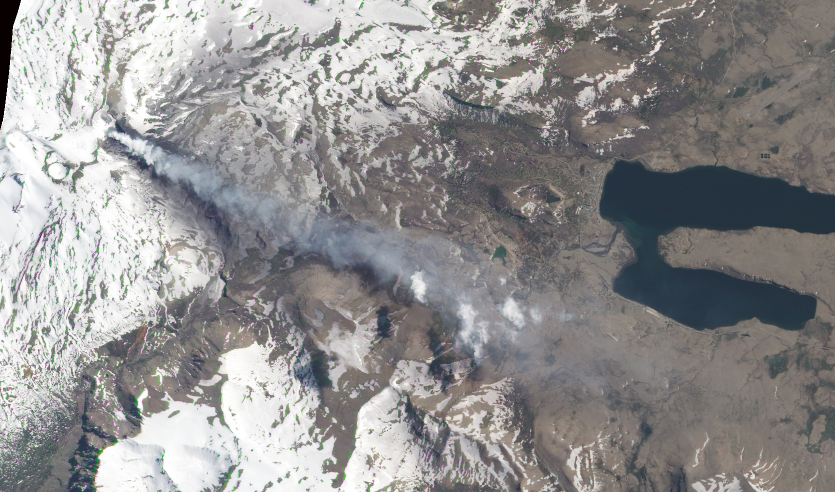 |
Figure 16. Natural-color satellite image of Copahue showing a volcanic plume streaming SE from the volcano on 21 October 2014. Image was acquired by the Advanced Land Imager (ALI) on Earth Observing-1. Courtesy of NASA Earth Observatory. |
The Buenos Aires VAAC reported that during 15-16 November 2014, diffuse steam-and-gas emissions containing a small amount of ash were detected by the webcam. The VAAC reported that on 26 November diffuse steam-and-gas emissions, seen in webcam and satellite images, may have contained a small amount of ash. The plume rose to altitudes of 3.4-3.7 km and drifted 65 km E. On 30 November a pilot observation and webcam views revealed a diffuse and continuous plume near the summit. During 1-2 December a diffuse plume was detected in satellite images, while the webcam recorded continuous ash emissions.
Activity during September 2015-January 2016. OVDAS-SERNAGEOMIN reported on 22 September 2015 that during the previous several days, web cameras had detected small explosions in the crater that dispersed incandescent material nearby. This activity, coupled with increased seismicity, increased SO2 emission levels, elevated emission temperatures, and partial loss of the crater lake, suggested a new eruption phase.
On 6 October 2015 observers noted sporadic crater glow, indicative of small explosions in El Agrio Crater. A grayish plume rose 200 m above the crater and drifted SE. According to the Buenos Aires VAAC, a pilot observed a gray plume rising to altitudes of 6.1-7.6 km and drifting NE on 11 October. Satellite images indicated no ash; the webcam recorded continuous emissions of steam and gas, and low levels of ash. The next day the webcam recorded weak steam-and-gas emissions, possibly with minor amounts of ash drifting SE. The VAAC also reported that the webcam recorded weak emissions of steam, gas, and possibly minor amounts of ash during 16-18 October.
Tremor amplitude began to oscillate on 19 November. On 20 November, crater incandescence coincided with small explosions that produced ash plumes. The Buenos Aires VAAC reported that, on 20 November, the webcam detected a continuous emission of steam and gas with minor amounts of ash; ash was not detected in satellite images.
During 16-30 November continuous ash explosions at the crater were recorded by the webcam; plumes rose as high as 1.3 km above the crater on 29 November. Satellite images detected ash plumes drifting as far as 560 km SE and ESE. During an overflight on 28 November, scientists observed the absence of the crater lake and a growing pyroclastic cone. Impact craters from ballistics ejected during minor explosions were within a radius of 300 m of the crater.
Based on satellite and webcam views, the Buenos Aires VAAC reported that during 18-20 December, steam and gas emissions with minor amounts of ash rose to altitudes of 3-3.6 km. Plumes drifted N on 18 December and 55-150 km SSE and SE on 19 December. During 20-22 December the webcam recorded continuous ash emissions drifting short distances. Diffuse ash plumes on 24-25, 27, and 29 December rose to altitudes of 3-3.6 km and drifted SE. On 30 December, diffuse gas and steam plumes possibly containing ash drifted SSE. The next day ash emissions drifted SW.
Based on satellite and webcam views, the Buenos Aires VAAC reported that on 6 January 2016 a gas and steam plume with minor amounts of ash rose to an altitude of 4.6 km. On 13 and 16 January, continuous gas-and-steam plumes containing minor amounts of ash drifted SE. During 20-23 January, almost continuous steam plumes containing minor amounts of ash drifted as far as 150 km W, S, SE, and E. During 28 January-2 February, almost continuous steam plumes containing minor amounts of ash rose to altitudes of 3-3.6 km and drifted as far as 160 km SE and SW. The Alert Level remained at Yellow.
The only MODIS/MODVOLC thermal anomalies during the reporting period were on 25 December 2015 (1 pixel), 30 December 2015 (2 pixels), and 31 December 2015 (1 pixel). The MIROVA (Middle InfraRed Observation of Volcanic Activity) volcano hotspot detection system, also based on analysis of MODIS data, detected one hotspot within 5 km of the volcano during the last week of April 2015 and numerous hotspots within 5 km from the middle of October through January 2016; the radiative power of the anomalies were all in the low or moderate range.
Geological Summary. Volcán Copahue is an elongated composite cone constructed along the Chile-Argentina border within the 6.5 x 8.5 km wide Trapa-Trapa caldera that formed between 0.6 and 0.4 million years ago near the NW margin of the 20 x 15 km Pliocene Caviahue (Del Agrio) caldera. The eastern summit crater, part of a 2-km-long, ENE-WSW line of nine craters, contains a briny, acidic 300-m-wide crater lake (also referred to as El Agrio or Del Agrio) and displays intense fumarolic activity. Acidic hot springs occur below the eastern outlet of the crater lake, contributing to the acidity of the Río Agrio, and another geothermal zone is located within Caviahue caldera about 7 km NE of the summit. Infrequent mild-to-moderate explosive eruptions have been recorded since the 18th century. Twentieth-century eruptions from the crater lake have ejected pyroclastic rocks and chilled liquid sulfur fragments.
Information Contacts: Observatorio Volcanológico de los Andes del Sur-Servicio Nacional de Geologia y Mineria (OVDAS-SERNAGEOMIN), Avda Sta María No. 0104, Santiago, Chile (URL: http://www.sernageomin.cl/); Oficina Nacional de Emergencia-Ministerio del Interior (ONEMI) (National Office of Emergency of the Interior Ministry)(URL: http://www.onemi.cl/); Buenos Aires Volcanic Ash Advisory Center (VAAC) (URL: http://www.smn.gov.ar/vaac/buenosaires/productos.php); Hawai'i Institute of Geophysics and Planetology (HIGP) MODVOLC Thermal Alerts System, School of Ocean and Earth Science and Technology (SOEST), Univ. of Hawai'i, 2525 Correa Road, Honolulu, HI 96822, USA (URL: http://modis.higp.hawaii.edu/)