Report on Heard (Australia) — August 2016
Bulletin of the Global Volcanism Network, vol. 41, no. 8 (August 2016)
Managing Editor: Edward Venzke.
Research and preparation by Jackie Gluck.
Heard (Australia) Intermittent thermal activity during 2013-14; plumes detected in 2015 and early 2016
Please cite this report as:
Global Volcanism Program, 2016. Report on Heard (Australia) (Venzke, E., ed.). Bulletin of the Global Volcanism Network, 41:8. Smithsonian Institution. https://doi.org/10.5479/si.GVP.BGVN201608-234010
Heard
Australia
53.106°S, 73.513°E; summit elev. 2745 m
All times are local (unless otherwise noted)
Thermal activity detected by MODIS (Moderate Resolution Imaging Spectroradiometer) recorded by the MODVOLC system occurred regularly from 21 September 2012 through 6 October 2013 (BGVN 38:08). This report covers thermal alerts and anomalies from the remainder of 2013 through March 2016, and describes the observations of two plumes, one by satellite image on 30 October 2015, and the other by scientists aboard a research vessel during 30-31 January 2016.
Thermal anomalies continued to be seen in MODIS data between October 2013 and 21 July 2014, and again on 16 November 2014, due to a persistent lava lake and possible lava flows. According to a NOAA National Environmental Satellite, Data, and Information Service (NESDIS) scientist, thermal anomalies seemingly on the E flank were detected in Visible Infrared Imaging Radiometer Suite (VIIRS) satellite images during 2-30 November 2014. Dense cloud cover prevented views during 1-2 December.
The frequency of MODVOLC alerts decreased in 2015, with the exception of frequent alerts during June and July 2015, with a single alert on 31 December. In early 2016 there were alerts measured on 28 January and 21 February.
A plume from Heard was visible in a U.S. Air Force satellite image drifting SSW on 30 October 2015. Data provided by Middle InfraRed Observation of Volcanic Activity (MIROVA) show frequent moderate thermal anomalies that tapered off after September 2015. MIROVA data also show that the frequent anomalies occurred farther from the summit during the early to mid-portion of 2015 (figure 22).
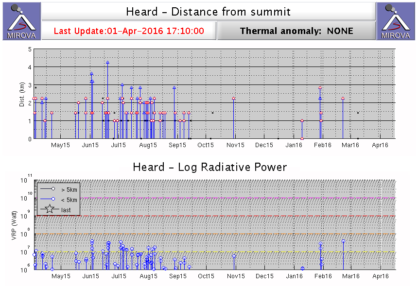 |
Figure 22. MIROVA graphs showing thermal anomalies at Heard 2 April 2015 to 1 April 2016. The log radiative power (bottom) indicates moderate thermal energy at distances (top) of generally 1-2.5 km from the summit. Recorded anomalies tapered off starting in early August 2015, with a few seen again in late January and February 2016. Courtesy of MIROVA. |
During 30-31 January 2016, scientists and crew aboard CSIRO's (Commonwealth Scientific and Industrial Research Organisation) Marine National Facility research vessel Investigator circled the island and observed a plume rising from Mawson Peak's crater and lava flows traveling down the NW flanks (figure 23). Visual observations are very rare due to its remote location. A MODVOLC thermal alert on 28 January was likely due to the lava emissions.
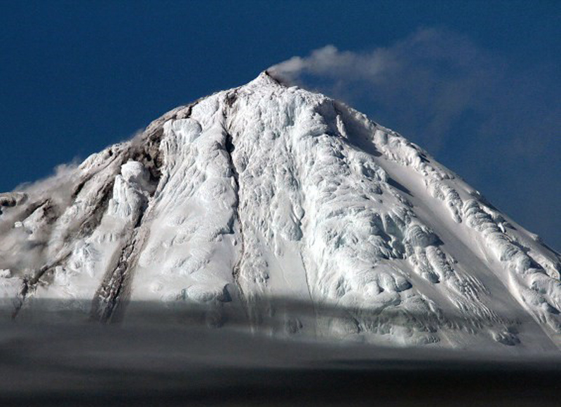 |
Figure 23. Small ash plume rising from Big Ben on Heard Island, 30-31 January 2016. On the flank at left in this view, the gray material is lava, from which steam is rising due to interaction with the snow and ice; a video taken at the same time shows the lava moving. Photo by Pete Harmsen; courtesy of CSIRO. |
Geological Summary. Heard Island on the Kerguelen Plateau in the southern Indian Ocean consists primarily of the emergent portion of two volcanic structures. The large glacier-covered composite basaltic-to-trachytic cone of Big Ben comprises most of the island, and the smaller Mt. Dixon lies at the NW tip of the island across a narrow isthmus. Little is known about the structure of Big Ben because of its extensive ice cover. The active Mawson Peak forms the island's high point and lies within a 5-6 km wide caldera breached to the SW side of Big Ben. Small satellitic scoria cones are mostly located on the northern coast. Several subglacial eruptions have been reported at this isolated volcano, but observations are infrequent and additional activity may have occurred.
Information Contacts: Marine National Facility, Commonwealth Scientific and Industrial Research Organisation (CSIRO), Hobart, Tasmania, Australia (URL: http://mnf.csiro.au/, https://blog.csiro.au/big-ben-erupts/); Michael J. Pavolonis, NOAA/NESDIS Center for Satellite Applications and Research (STAR), Advanced Satellite Products Branch (ASPB), Madison, Wisconsin, USA (URL: https://www.star.nesdis.noaa.gov/star/aspb_index.php); Hawai'i Institute of Geophysics and Planetology (HIGP), MODVOLC Thermal Alerts System, School of Ocean and Earth Science and Technology (SOEST), Univ. of Hawai'i, 2525 Correa Road, Honolulu, HI 96822, USA (URL: http://modis.higp.hawaii.edu/, http://modis.higp.hawaii.edu/cgi-bin/modisnew.cgi); MIROVA (Middle InfraRed Observation of Volcanic Activity), a collaborative project between the Universities of Turin and Florence (Italy) supported by the Centre for Volcanic Risk of the Italian Civil Protection Department (URL: http://www.mirovaweb.it/); United States Air Force, 557th Weather Wing, Weather Intel Flight, 2 WS/WXI Offutt AFB, NE 68133, USA.