Report on Raung (Indonesia) — December 2016

Bulletin of the Global Volcanism Network, vol. 41, no. 12 (December 2016)
Managing Editor: Edward Venzke.
Research and preparation by Jackie Gluck.
Raung (Indonesia) Strong eruptive activity and lava in the summit crater during June-August 2015
Please cite this report as:
Global Volcanism Program, 2016. Report on Raung (Indonesia) (Venzke, E., ed.). Bulletin of the Global Volcanism Network, 41:12. Smithsonian Institution. https://doi.org/10.5479/si.GVP.BGVN201612-263340
Raung
Indonesia
8.119°S, 114.056°E; summit elev. 3260 m
All times are local (unless otherwise noted)
Prior to January 2014, the most recent reported activity was during 12-17 June 2008, when ash plumes were seen rising to 4.5 km altitude (BGVN 33:06). Sporadic white and brownish plume emissions were noted between 2012 and early 2015, along with periods of increased seismicity and thermal anomalies. Gray plumes, presumably due to ash, were reported beginning on 1 February 2015. Seismicity and thermal anomalies preceded stronger eruptive activity that began in mid-to-late June 2015; the last reported gray plume was on 22 August 2015. Thermal anomalies also decreased after mid-August 2015.
Activity during 2012-2013. Seismicity increased on 17 October 2012, prompting the Pusat Vulkanologi dan Mitigasi Bencana Geologi (PVMBG) to raise the Alert Level to 2 (on a scale of 1-4) on 18 October. During 18-22 October white plumes rose 50-75 m above the crater. Seismic activity increased significantly again on 22 October. That same day the Alert Level was raised to 3; visitors and residents were warned not to approach the crater within a 3-km radius. Strong thermal anomalies identified by MODVOLC, based on MODIS infrared satellite data, began on 14 October and continued through 8 November 2012. Two additional weak anomalies were detected on 29 November and 1 December 2012.
PVMBG reported that during March 2013 white plumes rose to 400 m above the summit. Seismicity decreased significantly on 25 March; tremor was absent starting in April. On 5 April the Alert level was lowered to 2. Despite decreased seismicity, four MODVOLC thermal anomalies, based on MODIS satellite data, were recorded between 29 June and 31 July 2013.
Activity during 2014. PVMBG reported that on 1 January 2014 seismicity increased. On 3 January diffuse white gas plumes rose 100 m and drifted W; on 4 January diffuse brownish plumes also rose 100 m and drifted W. On 5 January the Alert Level was raised to 2.
PVMBG reported that RSAM values showed an increase in energy during March-April 2014. Also during this timeframe, the daily number of volcanic earthquakes was dominated by tremor (with an increase in tremor amplitude). However, beginning in May, the number and the amplitude of tremor decreased.
During 1-17 June 2014, when weather permitted, a weak solfatara plume was visible rising up to 100 m above the summit. On 17 June the Alert Level was lowered to 1. Thermal anomalies, based on MODIS satellite data, were recorded beginning 28 November 2014 and continuing through 25 February 2015.
Activity during 2015. From December 2014 through January 2015, white plumes were observed rising to 500 m above the crater rim. Throughout February and during 1-14 March plumes were gray-white and rose to a maximum height of 200 m. Crater incandescence and rumbling was also reported on 14 February. During 15 March-7 April gray-brown emissions rose to 200 m; rumbling was frequently heard. During 8 April- 21 May gray and gray-brown plumes rose to 300 m. Crater incandescence was observed again on 12 April. Seismicity fluctuated and was dominated by tremor. Rumbling was frequently heard during this interval. The Alert Level remained at 2; residents and tourists were reminded not to approach the craters within a 2-km radius.
Continuous tremor was recorded during December 2014-12 January 2015; tremor was not continuous starting on 13 January, and RSAM values declined. A weak thermal anomaly was recorded on 17 April 2015.
PVMBG reported that during times of clear weather during 1-28 June, white plumes were observed rising as high as 300 m above the crater rim. Rumbling was frequently heard at the observation post. Seismic tremor sharply increased on 21 June, and crater incandescence was observed on 25 and 28 June. BNPB reported that increased activity on 28 June was characterized by Strombolian activity, roaring, ash plumes that rose 300 m, and a loud thumping sound heard 20 km away at 2000. Incandescence from the crater was clearly visible from the observation post in Banyuwangi. PVMBG raised the Alert Level to 3 on 29 June, and reminded the public not to approach the crater within a 3-km radius.
Based on notices from the Ujung Padang Meteorological Watch Office (MWO) and PVMBG, satellite images, and pilot observations, the Darwin VAAC reported that during 1 and 3-7 July ash plumes rose to altitudes of 3.7-6.1 km and drifted 25-110 km E, ESE, and SE. According to news articles, flights in and out of an airport in Bali were cancelled due to ash emissions during 3-4 July. On 5 July BNPB reported that roaring was heard from continuous explosions and Strombolian activity. Dense white-and-gray plumes rose as high as 400 m and drifted SE.
During 1-8 July PVMBG reported that gray plumes rose 100-500 m above the crater rim, crater incandescence was observed, and rumbling and thumping noises were noted. Seismicity was dominated by high-amplitude tremor, and deformation data suggested magma migrating towards the surface. BNPB reported that gray ash plumes continued to rise as high as 500 m above the crater through 11 July (figure 5). Ash plumes drifted in various directions depending on the altitude; plumes drifted SE and S at lower altitudes and SE, S, W, and N at higher altitudes.
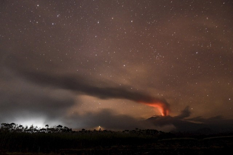 |
Figure 5. Volcanic ash and clouds are illuminated by lava from the crater of Mount Raung as seen from Songgon (Banyuwangi, East Java) on 11 July 2015. Courtesy of Reuters/Zabur Karuru/Antara Foto. |
Based on PVMBG notices, wind data, and satellite images, the Darwin VAAC reported that during 8-12 July ash plumes rose to an altitude of 4.3-5.2 km and drifted as far as 1,040 km E, SE, and S. According to news articles, increased activity during 9-10 July caused flight cancelations and several airports to close, including airports on Bali and Lombok, as well as Banyuwangi and Jember in East Java. One article noted that dozens of flight had been canceled during the previous week. Another article noted that the Bali airport, in addition to another airport in Java, again closed on 12 July, a day after it had reopened.
Information from PVMBG along with satellite-image and pilot observations, allowed the Darwin VAAC to report that during 15-21 July ash plumes rose to varying altitudes of 3.7-6.1 km and drifted as far as 340 km in multiple directions. On 16 July BNPB reported that a dense gray-to-black ash plume rose as high as 2 km above the crater rim and drifted WNW. Incandescent lava at the summit was visible, and tremor was continuous. Roaring and thumping sounds were reported by residents. Ashfall was reported in areas downwind, including Cumedak (19 km W) and Sumberjambe (13 km NW). According to a news article, the Juanda International Airport in Surabaya reopened on 17 July after on-and-off closures the previous week. BNPB noted that the eruption continued on 18 July with ash plumes rising as high as 1.5 km and drifting N. Tremor continued although the amplitude had declined during the previous week.
During 16-23 July PVMBG reported ash plumes rising to 2 km, and incandescence was visible at the crater. Seismicity fluctuated but remained elevated. Based on PVMBG information, and satellite-image and pilot observations, the Darwin VAAC reported that during 22-28 July ash multiple ash plumes rose to varying altitudes of 4.3-5.2 km and drifted as far as 400 km NW, W, SSW, S, and SSE. A news article from 29 July noted that 18 flights at most had been canceled during the previous few days due to the ash plumes, and that the Notohadinegoro Airport (2,100 km SW) had been temporarily closed.
On 4 August BNPB reported that during the previous three days the Strombolian eruption had increased in intensity. Ash fell in Sempu, Songgon, Glenmore, Gambiran, and Banyuwangi. On 4 August dense blackish gray ash plumes rose 800 m and drifted SE. Based on satellite-image and wind data, the Darwin VAAC reported that during 29 July-4 August multiple ash plumes rose to altitudes of 4.3-4.9 km and drifted as far as 240 km in multiple directions.
PVMBG reported that during 24 July-10 August ash plumes rose 1.5 km above the crater with visible incandescence at the crater. Seismicity fluctuated but remained elevated; RSAM values peaked on 4 August (the highest recorded since the beginning of the eruption) and then decreased significantly after mid-August (figure 6). Based on satellite observations and wind data, the Darwin VAAC reported that during 12-14, 16, and 18 August multiple ash plumes rose to altitudes of 3.7-4 km and drifted 20-110 km W and WSW (figure 7).
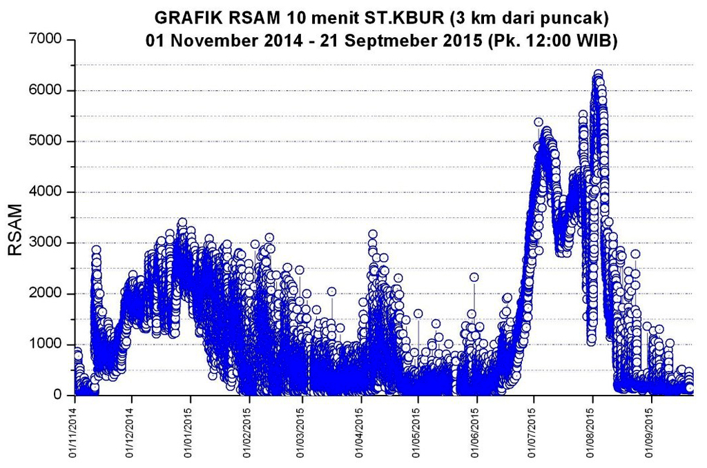 |
Figure 6. Realtime Seismic Amplitude Measurement (RSAM) measurements at Raung between 1 November and 21 September 2015. Courtesy of PVMBG. |
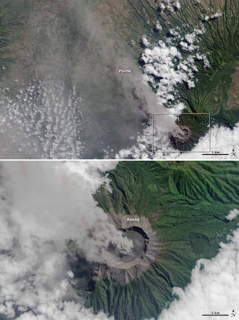 |
Figure 7. On 27 July 2015 the Operational Land Imager (OLI) on Landsat 8 captured a view of ash and volcanic gases drifting NW from Raung. The lower image shows a closer view of the volcano's caldera. Courtesy of NASA Earth Observatory; image by Jesse Allen (Landsat data from the U.S. Geological Survey) and caption by Adam Voiland. |
PVMBG reported that ash plumes rose as high as 1 km above the crater during 16-24 August and drifted NW. Seismicity fluctuated but continued to decrease. The Alert Level, which had remained at 3 since 29 June, was lowered to 2 on 24 August; the public was reminded not to approach the crater within a 2-km radius.
Based on weather models, webcam and satellite data, pilot observations, and information from PVMBG, the Darwin VAAC reported that on 19 August ash plumes rose to an altitude of 3.7 km and drifted 65-95 km NW, WNW, and W. On 22 August a low-level ash plume drifted 55 km NW.
PVMBG reported that, although inclement weather conditions often prevented visual observations during 25 August-21 September, white plumes were occasionally seen rising as high as 200 m above the crater. Seismicity fluctuated but continued to decrease. The Alert Level remained at 2 (on a scale of 1-4), and the public was reminded not to approach the crater within a 2-km radius.
In 2015 the MODVOLC system using infrared MODIS satellite data indicated a small anomaly on 17 April and then steady thermal anomalies beginning 20 June. The last anomaly located at the summit crater, a single weak alert pixel recorded on 29 August 2015, was a full week after the previous anomaly was identified on 22 August.
MODIS data analyzed by the Middle InfraRed Observation of Volcanic Activity (MIROVA) project from February 2015 through January 2016 (figure 8) showed a large spike in power output beginning in mid-June 2015. The slow descent after approximately the first week of August may be due to cooling of lava in the crater rather than to ongoing activity.
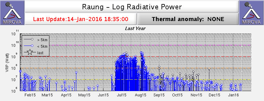 |
Figure 8. MODIS data analyzed by MIROVA shows a spike in power output coinciding with the beginning of elevated seismicity and ash plumes in June 2015. Courtesy of MIROVA. |
Geological Summary. Raung, one of Java's most active volcanoes, is a massive stratovolcano in easternmost Java that was constructed SW of the rim of Ijen caldera. The unvegetated summit is truncated by a dramatic steep-walled, 2-km-wide caldera that has been the site of frequent historical eruptions. A prehistoric collapse of Gunung Gadung on the W flank produced a large debris avalanche that traveled 79 km, reaching nearly to the Indian Ocean. Raung contains several centers constructed along a NE-SW line, with Gunung Suket and Gunung Gadung stratovolcanoes being located to the NE and W, respectively.
Information Contacts: Pusat Vulkanologi dan Mitigasi Bencana Geologi (PVMBG, also known as Indonesian Center for Volcanology and Geological Hazard Mitigation, CVGHM), Jalan Diponegoro 57, Bandung 40122, Indonesia (URL: http://www.vsi.esdm.go.id/); Badan Nasional Penanggulangan Bencana (BNPB), National Disaster Management Agency, Graha BNPB - Jl. Scout Kav.38, East Jakarta 13120, Indonesia (URL: http://www.bnpb.go.id/); Darwin Volcanic Ash Advisory Centre (VAAC), Bureau of Meteorology, Northern Territory Regional Office, PO Box 40050, Casuarina, NT 0811, Australia (URL: http://www.bom.gov.au/info/vaac/); Hawai'i Institute of Geophysics and Planetology (HIGP), MODVOLC Thermal Alerts System, School of Ocean and Earth Science and Technology (SOEST), Univ. of Hawai'i, 2525 Correa Road, Honolulu, HI 96822, USA (URL: http://modis.higp.hawaii.edu/, http://modis.higp.hawaii.edu/); MIROVA (Middle InfraRed Observation of Volcanic Activity), a collaborative project between the Universities of Turin and Florence (Italy) supported by the Centre for Volcanic Risk of the Italian Civil Protection Department (URL: http://www.mirovaweb.it/); NASA Earth Observatory, EOS Project Science Office, NASA Goddard Space Flight Center, Goddard, Maryland, USA (URL: http://earthobservatory.nasa.gov/); ch-aviation GmbH, Quaderstrasse 8, 7000 Chur, Switzerland (URL: http://www.ch-aviation.com/portal/news/38959-surabaya-indonesia-reopens-despite-mt-raung-eruption); WA Today, East Perth, WA, Australia (URL: http://www.watoday.com.au/wa-news/volcano-causes-more-bali-flight-cancellations-20150704-gi56a5.html); The Weather Channel (URL: http://www.weather.com/news/news/indonesia-mount-raung-volcan); The National, Abu Dhabi Media, Abu Dhabi, United Arab Emirates (URL: http://www.thenational.ae/world/mount-raung-eruption-causes-closure-of-bali-airport-again); The Jakarta Post, PT Niskala Media Tenggara, Jl. Palmerah Barat No. 142-143, Jakarta 10270, Indonesia (URL: http://www.thejakartapost.com/news/2015/07/29/mount-raungs-eruption-cancels-18-flights-jember.html).