Report on Langila (Papua New Guinea) — January 2017

Bulletin of the Global Volcanism Network, vol. 42, no. 1 (January 2017)
Managing Editor: Edward Venzke.
Research and preparation by Paul Berger.
Langila (Papua New Guinea) Weak ash plumes during April-May and November-December 2016
Please cite this report as:
Global Volcanism Program, 2017. Report on Langila (Papua New Guinea) (Venzke, E., ed.). Bulletin of the Global Volcanism Network, 42:1. Smithsonian Institution. https://doi.org/10.5479/si.GVP.BGVN201701-252010
Langila
Papua New Guinea
5.525°S, 148.42°E; summit elev. 1330 m
All times are local (unless otherwise noted)
After two explosions at Langila produced ash plumes that rose to 1.5 and 2.1 km in early December 2012 (BGVN 41.01), no further information about the volcano's activity was available from the Rabaul Volcano Observatory or the Darwin VAAC until April 2016. This report discusses two new eruptions in 2016, one during 2 April-13 May and the other during 3 November-24 December. Observations of ash plumes continued into mid-January 2017.
Thermal anomalies, based on MODIS satellite instruments analyzed using the MODVOLC algorithm, were occasionally detected after 2012. During 2013, seven anomalies were reported during 23 October-1 December (4 pixels on 25 October); during 2014-2015, a possible anomaly was identified on 23 August 2014 NE of the crater and thus probably not associated with volcanic activity.
During 2016, the Darwin VAAC reported the ejection of several ash plumes during 2 April-13 May and 3 November-24 December (table 3). Most plumes rose between 2-3.3 km in altitude. MODVOLC thermal alerts were also seen during those two periods, with six anomalies during April and May, and one reported in November During 20-27 December 2016, five thermal anomalies were reported (most with more than one pixel). Two alert pixels in August were weak and somewhat E of the volcano, and probably not associated with activity.
Table 3. Ash plumes from Langila reported during April-May and November-December 2016. Observations are based on analyses of satellite imagery, ground observations by the Rabaul Volcano Observatory, and wind data; dates are based on local time. Courtesy of the Darwin VAAC.
| Date | Max. Plume Altitude (km) | Drift |
| 02-03 Apr 2016 | 2.1 | 35-65 km N, NE, E |
| 06-07 Apr 2016 | 3 | 55 km NE, E |
| 21-22 Apr 2016 | 2.1 | 75-110 km N |
| 09-10 May 2016 | 2.1-3 | 75 km N, NW, W |
| 11-13 May 2016 | 2.1 | 25-85 km NNW, NW, W |
| 03 Nov 2016 | 3.3 | 55 km W |
| 04 Nov 2016 | 3.3 | NW |
| 13 Nov 2016 | 2.1 | 55 km N |
| 16 Nov 2016 | 4.3 | 30 km SE |
| 01-06 Dec 2016 | 2.1-3 | NE, NW, W (40 km on 3 Dec) |
| 08-09, 11, 13 Dec 2016 | 1.8-2.4 | 110 km W, WNW, N |
| 21-24 Dec 2016 | 2.4 | N, NW, S, SE |
The Mirova (Middle InfraRed Observation of Volcanic Activity) volcano hotspot detection system, also based on analysis of MODIS data, also detected occasional hotspots during 2016 (figure 5). Most occurred during April-May and November-December, but a few intermittent anomalies were noted every month during June-October as well. The heat radiated by the volcanic activity (or Volcanic Radiative Power, as measured in watts) was mostly less than 0.5 W.
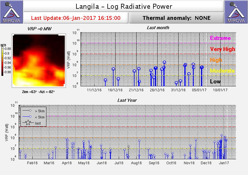 |
Figure 5. Plot of MIROVA thermal anomaly MODIS data during 7 January 2016-6 January 2017. Periods of more frequent anomalies in April-May and November-December 2016 correspond to reports of ash plumes. Courtesy of MIROVA. |
Geological Summary. Langila, one of the most active volcanoes of New Britain, consists of a group of four small overlapping composite basaltic-andesitic cones on the lower E flank of the extinct Talawe volcano in the Cape Gloucester area of NW New Britain. A rectangular, 2.5-km-long crater is breached widely to the SE; Langila was constructed NE of the breached crater of Talawe. An extensive lava field reaches the coast on the N and NE sides of Langila. Frequent mild-to-moderate explosive eruptions, sometimes accompanied by lava flows, have been recorded since the 19th century from three active craters at the summit. The youngest and smallest crater (no. 3 crater) was formed in 1960 and has a diameter of 150 m.
Information Contacts: Darwin Volcanic Ash Advisory Centre (VAAC), Bureau of Meteorology, Northern Territory Regional Office, PO Box 40050, Casuarina, NT 0811, Australia (URL: http://www.bom.gov.au/info/vaac/); Rabaul Volcano Observatory (RVO), PO Box 386, Rabaul, Papua New Guinea; Hawai'i Institute of Geophysics and Planetology (HIGP), MODVOLC Thermal Alerts System, School of Ocean and Earth Science and Technology (SOEST), Univ. of Hawai'i, 2525 Correa Road, Honolulu, HI 96822, USA (URL: http://modis.higp.hawaii.edu/, http://modis.higp.hawaii.edu/); MIROVA (Middle InfraRed Observation of Volcanic Activity), a collaborative project between the Universities of Turin and Florence (Italy) supported by the Centre for Volcanic Risk of the Italian Civil Protection Department (URL: http://www.mirovaweb.it/).