Report on Rabaul (Papua New Guinea) — February 2017

Bulletin of the Global Volcanism Network, vol. 42, no. 2 (February 2017)
Managing Editor: Edward Venzke.
Edited by A. Elizabeth Crafford.
Rabaul (Papua New Guinea) Details of 29 August 2014 Strombolian eruption; update through 2016
Please cite this report as:
Global Volcanism Program, 2017. Report on Rabaul (Papua New Guinea) (Crafford, A.E., and Venzke, E., eds.). Bulletin of the Global Volcanism Network, 42:2. Smithsonian Institution. https://doi.org/10.5479/si.GVP.BGVN201702-252140
Rabaul
Papua New Guinea
4.2459°S, 152.1937°E; summit elev. 688 m
All times are local (unless otherwise noted)
The large eruption of 29 August 2014 at the Tavurvur stratovolcano of Rabaul caldera, on the NE tip of New Britain Island in Papua New Guinea, followed a period of minor ash eruptions earlier in the year (BGVN 39:08). The volcano has been intermittently active since a major eruption in September 1994, which was its first eruption in over 50 years. During the 1994 eruption, a lava flow, tephra ejection, and an ash plume rising to 18 km caused the evacuation of over 50,000 people from the surrounding area, significant damage to nearby Rabaul Town, several deaths, and disrupted air traffic for several days (BGVN 19:08, 19:09). Additional information for the 2014 eruption, and subsequent activity covered in this report, was compiled by the Rabaul Volcano Observatory (RVO) and issued by the Department of Mineral Policy and Geohazards Management of Papua New Guinea (DMPGM). Aviation alerts for Rabaul are issued by the Darwin Volcanic Ash Advisory Center (VAAC). A number of news outlets also covered the eruption with photographs, videos, and interviews of local residents.
A Strombolian eruption at Tavurvur began shortly after 0330 local time on 29 August 2014. This was followed by an ash plume rising to 18 km altitude. Smaller explosions at irregular intervals continued through 0641 on 30 August. After this, plumes of white vapor and slightly bluish gas returned, except for an ash plume reported on 12 September and a small explosion on 18 September. The volcano remained quiet after this and through 2016, although ground deformation data indicated a gradual inflation of about 6 cm over the period.
Activity during August-December 2014. Prior to August 2014, DMPGM reported that ground deformation measurements from the GPS station on Matupit Island (3 km W) had been showing increasing inflation, first detected in March 2014 (figure 67). In the days immediately before the 29 August 2014 eruption, Tavurvur had been emitting a diffuse plume of white vapor. An explosion occurred on 6 August, and an inspection of the summit crater on 8 August revealed an incandescent area covered by debris.
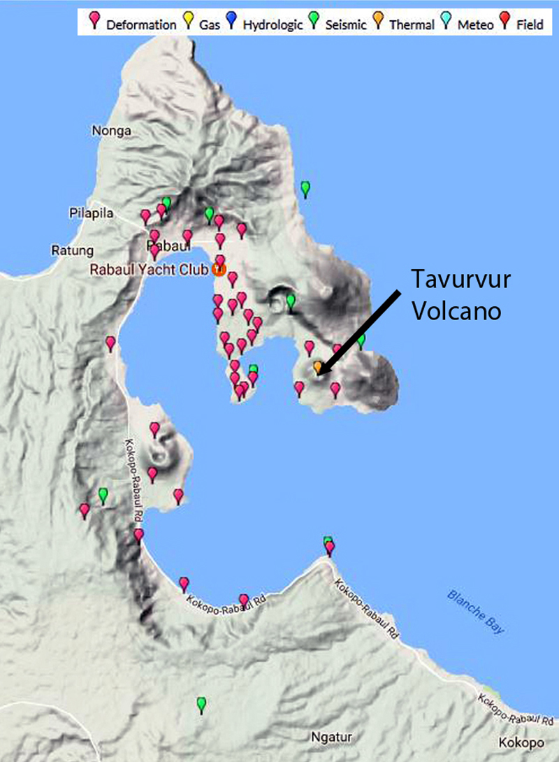 |
Figure 67. Locations of ground deformation (red), seismic (green) and thermal (orange) monitoring stations around Tavurvur volcano at Rabaul Caldera, New Britain Island, Papua New Guinea. Matupit Island is the peninsula immediately W of Tavurvur. Image courtesy WOVOdat. |
The activity on 29 August 2014 started slowly between 0330 and 0400 local time and then developed into a Strombolian eruption accompanied by loud explosions, roaring, and rumbling. The stronger explosions generated shockwaves which rattled windows and doors in the area. At dawn, the eruption plume could be seen blowing W over the Malguna villages, about 8 km NW, at an altitude of 3,000 m (figure 68). Rabaul Town, 7 km NW of Tavurvur, was initially affected by ash, as was Volavolo (20 km W), but a shift in wind direction sent the plume in a more WNW direction by mid-morning. Villages to the E and S were not affected by ash, but ashfall was reported in Keravat, about 25 km SW. High levels of seismic tremor were recorded during the eruption.
 |
Figure 68. Eruption of Mt. Tavurvur, the active stratovolcano of Rabaul caldera, on 29 August 2014. The ash plume rose to 18 km altitude and dispersed ash to the W and NW of the volcano. Courtesy of OLIVER BLUETT/AFP/Getty Images, printed in The Washington Post. |
DMPGM reported that the Strombolian eruption had begun to subside around 0645, and by 0700 only a diffuse white plume was being emitted and seismicity had decreased. Another report at 1600 noted that strong explosions continued throughout the day at irregular intervals, producing ash plumes that rose rapidly to 1,000 m above the summit before drifting NW. The explosions also ejected lava fragments of various sizes in all directions 500 to 1,000 m from the summit crater (figure 69). Shock waves accompanied the loud explosions and rattled buildings within several kilometers of the volcano. Intermittent explosions at increasing intervals continued into the following night generating incandescent lava fragments around the summit. Seismicity was dominated by discrete events that were associated with the explosions. The strong explosions ceased at 0641 on 30 August, and no incandescence was observed after that. By the morning of 31 August, seismicity had decreased from 80 events/hour to 15/hour. According to DMPGM, the eruption deposited a significant amount of ash and scoria on the hillsides of Rabaul Town and Malaguna Villages to the NW.
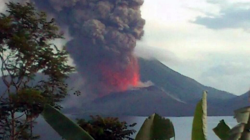 |
Figure 69. Incandescent lava exploding from Tavurvur (Rabaul Caldera) on 29 August 2014. Courtesy of Emma Edwards, reported at Traveller.com. |
The initial ash plume from the eruption was first observed in satellite imagery by the Darwin VAAC around 0900 local time on 29 August, and rose to over 18 km altitude. The upper part of the plume was originally drifting SW, then changed to NW, and the lower part at 4.3 km altitude was moving NW. By late morning, the plume was moving in three directions at different altitudes; NW at 4.3 km, S at 16.7 km, and W at 18.3 km. The high-level ash from the original eruption had dissipated by the evening on 30 August, but low-level plumes to 2.1 km were still reported.
A substantial SO2 plume was recorded by the OMI Instrument on the Aura Satellite on 29 August, and was still measurable a day later (figure 70) drifting S. The MODVOLC thermal anomaly system recorded anomalous pixels at Rabaul captured by MODIS satellite data between 29 August and 1 September 2014.
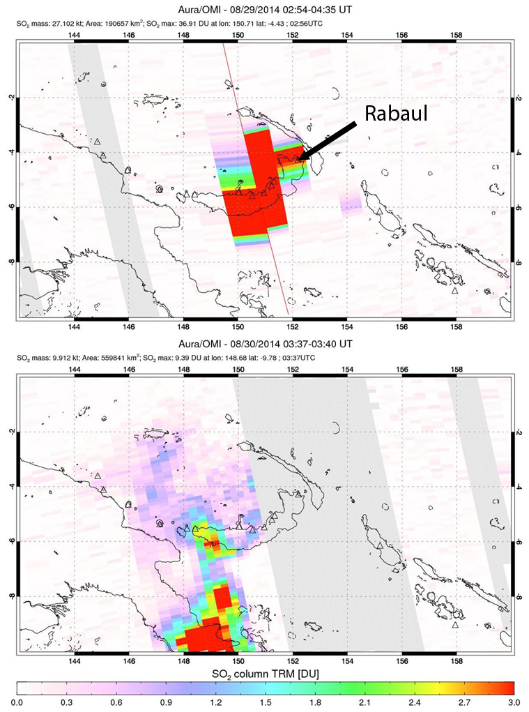 |
Figure 70. SO2 plumes captured by the OMI instrument on the AURA satellite from Rabaul on 29 and 30 August 2014. Rabaul is the triangle at the top right corner of the crescent shaped island of New Britain at the center of the image. Courtesy of NASA/GSFC. |
From 1 to 17 September emissions consisted of variable amounts of diffuse to dense white vapor and small traces of diffuse blue vapor. Southeast winds were recirculating significant amounts of fine ash back into the atmosphere. A plume was reported by the Darwin VAAC on 12 September at 3 km altitude, drifting NW. Seismicity had decreased to very low levels with only 10-30 events recorded per day during the first half of September. A single small explosion occurred at 1242 on 18 September according to DMPGM that produced a small, light-gray ash plume that rose a few hundred meters above the summit crater before dissipating to the NW.
A site inspection of Tavurvur crater was conducted by DMPGM on 23 September 2014, and they observed significant changes in the crater since the 29 August eruption. The crater floor was filled with blocky lavas, and thus much shallower than when last observed prior to the eruption. Three or four areas of active emissions were present within the crater, and the rim was covered with large blocks of lava. By the end of September, seismicity had dropped to less than 10 low-frequency earthquakes per week. In mid-October DMPGM observed that the ground deformation data from the Matupit GPS station indicated that there had been an inflation of about 4 cm since the benchmark reached on 29 August during the eruption. Ground deformation was stable during November. During a field inspection of the summit crater on 9 December 2014, scientists measured a temperature of 310°C at a hot spot on the upper flank. Numerous patches of diffuse white vapor emissions were present at different places on the inner walls of the crater, and the crater floor seemed to have subsided slightly since the prior visit.
Activity during 2015 and 2016. A report by DMPGM from March 2015 noted that Tavurvur remained quiet with the summit crater releasing various amounts of diffuse white vapor, which was slightly denser during periods of rain. There was no observed incandescence or noise, and seismicity was low, with only a small number of both high-frequency and volcano-tectonic earthquakes recorded on 10 and 13 February. Ground deformation data indicated a general inflationary trend since September 2014 of about 5 cm. Monthly reports issued by DMPGM in March and April indicated little activity at Tavurvur, and stability of the ground deformation data. On 17 May 2015 a strong, earthquake of M 5.1 originating NE of Rabaul Caldera 1-2 km offshore from Korere and Nodup (about 9 km NW of Tavurvur) generated a swarm of aftershocks in the same area. They occurred at a depth of about 9 km and caused several small landslides in various places on the N flank of Kombiu, another stratovolcano at Rabaul about 2.5 km NE of Tavurvur.
Tavurvur remained quiet from September through November with occasional diffuse white vapor plumes rising from the summit caldera, and no volcanic earthquakes reported. While a long-term inflationary trend continued through November, shorter term fluctuations up and down of a few centimeters in the ground deformation data were also observed. The trend of vertical uplift between January 2015 and December 2016 showed an increase of approximately 6 cm during the period (figure 71).
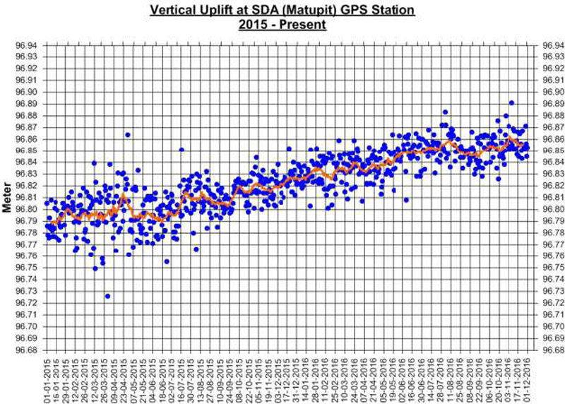 |
Figure 71. Vertical uplift at the Matupit GPS station for Rabaul between 1 January 2015 and 1 December 2016. The trend shows a gradual inflation of about 6-7 cm. Courtesy of DMPGM (Volcano Information Bulletin No. 12-122016, 4 December 2016). |
Geological Summary. The low-lying Rabaul caldera on the tip of the Gazelle Peninsula at the NE end of New Britain forms a broad sheltered harbor utilized by what was the island's largest city prior to a major eruption in 1994. The outer flanks of the asymmetrical shield volcano are formed by thick pyroclastic-flow deposits. The 8 x 14 km caldera is widely breached on the east, where its floor is flooded by Blanche Bay and was formed about 1,400 years ago. An earlier caldera-forming eruption about 7,100 years ago is thought to have originated from Tavui caldera, offshore to the north. Three small stratovolcanoes lie outside the N and NE caldera rims. Post-caldera eruptions built basaltic-to-dacitic pyroclastic cones on the caldera floor near the NE and W caldera walls. Several of these, including Vulcan cone, which was formed during a large eruption in 1878, have produced major explosive activity during historical time. A powerful explosive eruption in 1994 occurred simultaneously from Vulcan and Tavurvur volcanoes and forced the temporary abandonment of Rabaul city.
Information Contacts: Department of Mineral Policy and Geohazards Management (DMPGM), Volcano Observatory, Geohazards Management Division, PO Box 3386, KOKOPO, East New Britain Province, Papua New Guinea; Darwin Volcanic Ash Advisory Centre (VAAC), Bureau of Meteorology, Northern Territory Regional Office, PO Box 40050, Casuarina, NT 0811, Australia (URL: http://www.bom.gov.au/info/vaac/); Hawai'i Institute of Geophysics and Planetology (HIGP), MODVOLC Thermal Alerts System, School of Ocean and Earth Science and Technology (SOEST), Univ. of Hawai'i, 2525 Correa Road, Honolulu, HI 96822, USA (URL: http://modis.higp.hawaii.edu/, http://modis.higp.hawaii.edu/cgi-bin/modisnew.cgi); NASA Goddard Space Flight Center (NASA/GSFC), Global Sulfur Dioxide Monitoring Page, Atmospheric Chemistry and Dynamics Laboratory, Goddard, Maryland, USA (URL: https://so2.gsfc.nasa.gov/); World Organization of Volcano Observatories (WOVOdat), hosted by Earth Observatory of Singapore, Nanyang Technological University, 50 Nanyang Avenue, Singapore 639798 www.wovodat.org; The Washington Post, http://www.washingtonpost.com/news/morning-mix/wp/2014/08/29/photos-in-papua-new-guinea-mount-tavurvur-explodes-in-spectacular-style/); Traveller.com, http://www.traveller.com.au/qantas-reroutes-flights-as-pngs-rabaul-volcano-erupts-109utz .