Report on Marapi (Indonesia) — February 2017
Bulletin of the Global Volcanism Network, vol. 42, no. 2 (February 2017)
Managing Editor: Edward Venzke.
Research and preparation by Paul Berger.
Marapi (Indonesia) Phreatic explosion on 14 November 2015 causes ashfall on the SW flank
Please cite this report as:
Global Volcanism Program, 2017. Report on Marapi (Indonesia) (Venzke, E., ed.). Bulletin of the Global Volcanism Network, 42:2. Smithsonian Institution. https://doi.org/10.5479/si.GVP.BGVN201702-261140
Marapi
Indonesia
0.38°S, 100.474°E; summit elev. 2885 m
All times are local (unless otherwise noted)
Explosions occurred at Marapi (not to be confused with the better known Merapi on Java) during August 2011; March, May, and September 2012; and February 2014 (BGVN 40:05). This report discusses activity during 2015 and 2016. All information was provided by the Indonesian Center of Volcanology and Geological Hazard Mitigation (PVMBG, also known as CVGHM). During the reporting period, the Alert Level remained at 2 (on a scale of 1-4); residents and visitors were advised not to enter an area within 3 km of the summit.
According to PVMBG, diffuse white plumes rose as high as 300 above Marapi's crater during February-25 May 2015, 150 m above the crater during 1 August-16 November 2015, and 250 m above the crater during 1 November 2015-19 January 2016. Inclement weather often prevented observations.
Seismicity fluctuated during this time, dominated by earthquakes centered a long distance from the volcano. However, tremor increased significantly during August 2015 through at least the middle of January 2016 (figure 4). A phreatic explosion at 2233 on 14 November 2015, generated an ash plume, and ashfall was noted in Panyalaian and Aia Angek on the SW flank.
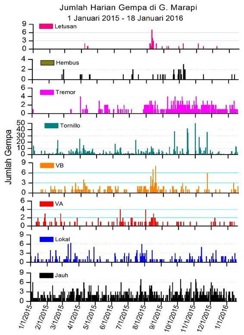 |
Figure 4. Types and daily number of earthquakes recorded at Marapi during 1 January 2015-18 January 2016. Key: eruptive earthquakes (Letusan), emission-type "blowing" earthquakes (Hembus), shallow earthquakes (VB), deep earthquakes (VA), local earthquakes (Lokal), and long-distance earthquakes (Jauh). The terms shallow and deep were not quantified. Courtesy of PVMBG (23 January 2016 report). |
Geological Summary. Gunung Marapi, not to be confused with the better-known Merapi volcano on Java, is Sumatra's most active volcano. This massive complex stratovolcano rises 2,000 m above the Bukittinggi Plain in the Padang Highlands. A broad summit contains multiple partially overlapping summit craters constructed within the small 1.4-km-wide Bancah caldera. The summit craters are located along an ENE-WSW line, with volcanism migrating to the west. More than 50 eruptions, typically consisting of small-to-moderate explosive activity, have been recorded since the end of the 18th century; no lava flows outside the summit craters have been reported in historical time.
Information Contacts: Pusat Vulkanologi dan Mitigasi Bencana Geologi (PVMBG, also known as Indonesian Center for Volcanology and Geological Hazard Mitigation, CVGHM), Jalan Diponegoro 57, Bandung 40122, Indonesia (URL: http://www.vsi.esdm.go.id/).