Report on Veniaminof (United States) — February 2017

Bulletin of the Global Volcanism Network, vol. 42, no. 2 (February 2017)
Managing Editor: Edward Venzke.
Edited by A. Elizabeth Crafford.
Veniaminof (United States) Lava flows, Strombolian activity, and ash plumes during 13 June-17 October 2013
Please cite this report as:
Global Volcanism Program, 2017. Report on Veniaminof (United States) (Crafford, A.E., and Venzke, E., eds.). Bulletin of the Global Volcanism Network, 42:2. Smithsonian Institution. https://doi.org/10.5479/si.GVP.BGVN201702-312070
Veniaminof
United States
56.17°N, 159.38°W; summit elev. 2507 m
All times are local (unless otherwise noted)
Mount Veniaminof, located on the Alaska Peninsula, has a large glacier-filled summit caldera that formed around 3,700 years ago. A cone within the crater has been the source of at least 13 eruptions in the last 200 years that included intermittent steam and ash emissions, incandescent lava flows, and Strombolian activity. Prior to an eruptive episode that began in June 2013, lava had last erupted during Strombolian activity in February 2005; subsequent minor ash emissions occurred later in 2005, November 2006, and February 2008. Pilots reported ash plumes in January and June 2009, but the Alaska Volcano Observatory (AVO) concluded that the plumes were steam-only. Veniaminof is closely monitored by AVO and the Anchorage Volcanic Ash Advisory Center (VAAC). The Federal Aviation Administration (FAA) also has a web camera in Perryville, 35 km E of the volcano. This review draws heavily from a USGS report on the June through October 2013 eruption (Dixon et al., 2015).
Beginning on 7 June 2013, a several-day period of increasing levels of seismic tremor indicated the start of a largely effusive eruption from the intracaldera cinder cone (figure 17). The first ash plume was observed on 13 June. Over the next four months, numerous emissions rose to altitudes generally below 4.6 km and coated the flanks of the cone with ash, Strombolian explosions were visually observed several times, and lava flowed down the N and S flanks of the active cone and advanced onto the surrounding ice-filled caldera creating ice cauldrons. The eruption constructed a new spatter cone within the summit crater of the main active cone. Activity had ceased by 17 October 2013. A brief period of elevated seismicity occurred during October and November 2015, but no eruptive activity was recorded.
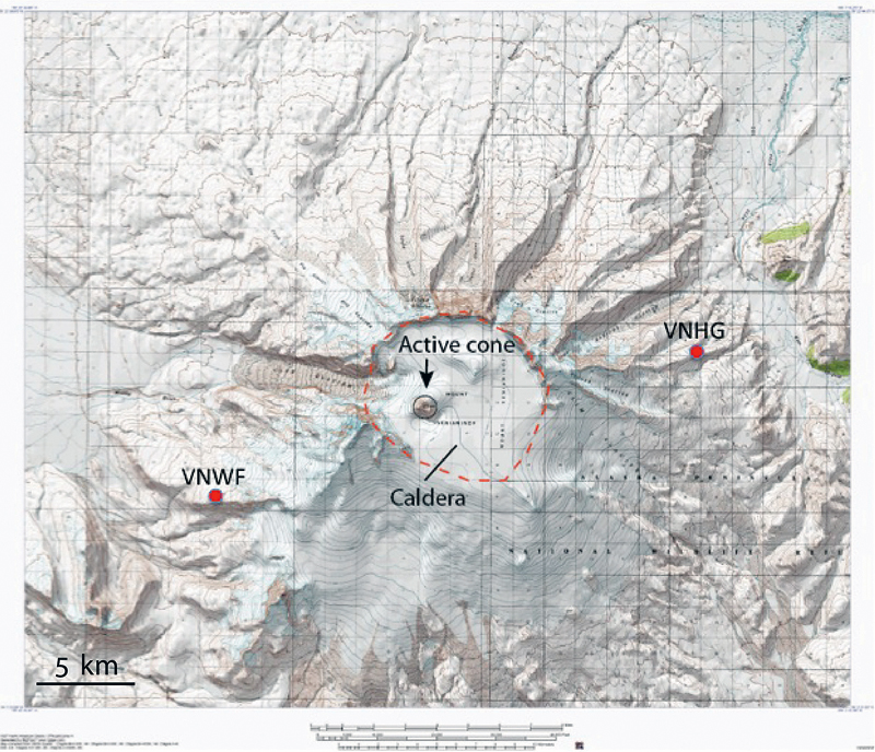 |
Figure 17. Topographic map of Mount Veniaminof showing the margin of the caldera (red dashed line) and the active cone within the caldera (black circle). Seismic stations VNWF and VNHG were the most fully operable of the network in June 2013. The caldera is 10 km in diameter. Courtesy of AVO/UAFGI, 19 June 2013 (AVO database image URL: http://www.avo.alaska.edu/images/image.php?id=50831). |
Gradually increasing low-frequency tremor was recorded on two seismograph stations at Veniaminof, along with elevated surface temperatures of the intracaldera cinder cone recorded via satellite images on 7 June 2013. This led AVO to increase the 4-level Aviation Color Code and the Volcano Alert Level from Green/Normal to Yellow/Advisory the next day. By 13 June, seismicity levels and elevated surface temperatures at the summit of the cinder cone (as measured by satellite images) indicated an eruption was likely underway, causing AVO to raise the Aviation Color Code and the Volcano Alert Level to Orange/Watch. Observation of an ash plume at an altitude of 3.7 km by a pilot that evening along with a lava flow effusing from the intra-caldera cinder cone confirmed the eruption.
Residents in Perryville (32 km SSE) and Port Moller (77 km WSW) also observed ash emissions at about 2330 local time that evening. The first VAAC report around the same time listed the ash plume at 4.3 km altitude, drifting NNE. Ash deposits on the snow-covered caldera floor, and lava on the cone, were visible in satellite images on 14 June. The first MODVOLC thermal anomaly pixels from MODIS satellite data also appeared on 14 June. On 18 June the web camera in Perryville captured short-lived ash plumes rising to less than 4.6 km, and residents in Sandy River (33 km W) reported visible plumes to similar altitudes the next day. The 100-m-wide lava flow extended 500 m down the SW flank of the cone onto the adjacent snow and ice field by 18 June. Interaction of the lava with the caldera snow-and-ice field generated water-rich ash plumes. Clear satellite views the following day showed active flow lobes advancing over the ice at the base of the cone.
In subsequent weeks, three flows descended the S flank, and minor amounts of ash accumulated on the caldera floor. Strombolian activity was captured by infrared satellite imagery, from the FAA web camera in Perryville, and from several local lodges and remote camps (figure 18).
 |
Figure 18. Telephoto view of erupting Mount Veniaminof, 9 July 2013. Photograph was taken from Sandy River about 32 km W of the volcano. Bright orange incandescence indicates lava fountaining from the vent hidden from view within the crater atop the cinder cone. At times, the eruption was characterized by closely spaced bursts that produced 'puffs' of ash. Courtesy of AVO/USGS. Photograph by William Jasper, used with permission (AVO database image URL: http://www.avo.alaska.edu/images/image.php?id=56303 ). |
On 16 July 2013 an AVO geologist visited the caldera by helicopter, making observations and taking the first close-up photographs documenting the lava flows and ice cauldron formation (figure 19). Images of the vent area showed a new cone of accumulated spatter nested within the summit crater of the main cone.
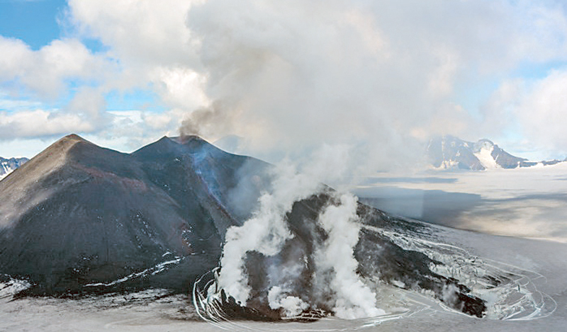 |
Figure 19. Southwestern flank of the intracaldera cone at Mount Veniaminof on 16 July 2013 showing lava flows emplaced during the eruptive activity occurring in June and July 2013, and a new cone formed from eruptive spatter. View is toward the east. The flows appear similar to those produced during the 1993 eruption. Courtesy of AVO/USGS. Photograph by Chris Waythomas, 16 July 2013 (AVO database image URL: http://www.avo.alaska.edu/images/image.php?id=51301 ). |
Strong MODVOLC thermal alert pixels, up to 12 per day, continued almost daily through the end of July. A pilot report from 0800 AKDT on 25 July described an ash plume to 100 m above the erupting cone dispersing 25 km to the S, and a "river of lava" flowing from the intracaldera cone. Numerous reports from the Anchorage VAAC between 27 and 31 July confirmed ash plumes rising as high as 4.6 km altitude and drifting up to 20 km NW.
After a brief period of quiet in early August 2013, activity resumed with lava flows and ash plumes on 11 August. On 12 August, satellite imagery confirmed incandescence from the cone and an ash plume was also observed from Perryville. A second overflight under clear skies by AVO geologists on 18 August revealed ash covering the immediate area of the glacier and the lava flows, and an active incandescent flow down the S flank into the ice cauldrons where the hottest parts of the flows were still in contact with ice and water. The S-flank lava flows had coalesced and largely melted into the surrounding ice (figures 20 and 21).
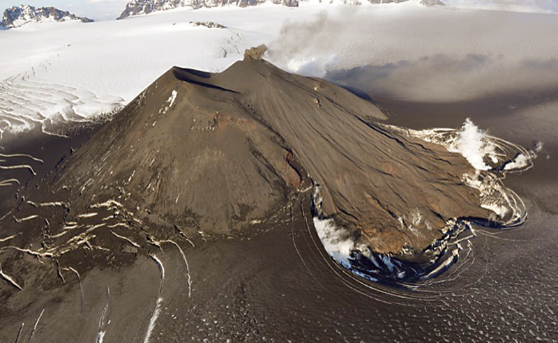 |
Figure 20. A small puff of ash emerges from the active cone inside the Veniaminof caldera on 18 August 2013. A fan of lava flows active earlier in the summer descends the southern flank of the cone onto glacial ice, producing white steam clouds and depressions where melting has occurred. The surrounding glacier is darkened by recent ashfall. Courtesy of USGS/AVO. Photograph by Game McGimsey (AVO database image URL: http://www.avo.alaska.edu/images/image.php?id=55761 ). |
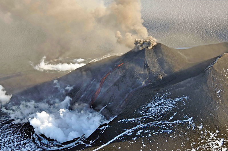 |
Figure 21. Aerial view of the eruption at Veniaminof's intracaldera cone on 18 August 2013, from an overflight co-sponsored by the National Geographic Society. The cone rises about 300 m above the surrounding icefield. An incandescent orange stream of lava is emerging from the active cone. Steam billows from the pit at the base of the cone where the lava encounters and melts ice and snow creating an ice cauldron. The small, ash-rich plume rising just above the vent produced a diffuse ash cloud that drifted downwind. Courtesy of AVO/USGS. Photograph by Game McGimsey, AVO/USGS (AVO database image at URL: http://www.avo.alaska.edu/images/image.php?id=56211 ). |
Strombolian explosions of incandescent lava and minor ash emissions were observed at the central active vent on 18 August during the flyover. Two new lava flows were also observed issuing from the NE flank of the new cone. Forward Looking Infrared Radiometer (FLIR) images delineated the lava flows and hot spatter on the cone (figure 22). As measured by the FLIR, maximum temperatures reached 700° to 800°C.
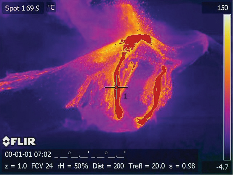 |
Figure 22. Forward Looking Infrared Radiometer (FLIR) image of the erupting intracaldera cone of Mount Veniaminof on 18 August 2013. In this oversaturated image (due to low thermal imagery setting), the active lava flows (hottest) are red and the lava fountaining at the summit is easily visible. These lava flows are on the NE flank of the cone. Maximum temperatures recorded were between 700° and 800° C. Courtesy of USGS/AVO. FLIR image by Game McGimsey (AVO database image URL: http://www.avo.alaska.edu/images/image.php?id=57831). |
The Anchorage VAAC reported ash plumes on 20 and 21 August 2013 rising to 3.7 km altitude moving SE within a few kilometers of the summit. Residents of Perryville reported rumbling noises, explosions, and trace ashfall on 20 August. Similar, low-level ash plumes and persistent thermal anomalies were detected during the remainder of August. A noted increase in activity on 30 August included elevated levels of continuous tremor, lava fountaining, and ash emissions as high as 6.1 km altitude; this was some of the strongest unrest detected since the eruption began in June. Trace amounts of ashfall were again reported in Perryville. Lava effusion, fountaining, and nearly continuous small ash plumes continued through the first week in September. Satellite and aerial images on 6 and 7 September indicated further development of the flows on the NE flank and expansion of the ice cauldron as well as a new lobe of lava advancing southward from the NE flank ice cauldron (figure 23).
 |
Figure 23. Aerial view of Mount Veniaminof erupting on 7 September 2013. Note the white water vapor clouds indicating that hot lava is interacting with snow and ice. A gray-brown ash column rises from the active vent. The advancing flows in foreground are on the southeastern flank of the cone and were the last flows emplaced in the 2013 eruption. The summit ice field is darkened with recent ash fall. Courtesy AVO/USGS. Photograph by Joyce Alto, used with permission (AVO database image URL: http://www.avo.alaska.edu/images/image.php?id=56424). |
MODVOLC thermal alert pixels ceased on 8 September 2013; the last September satellite imagery detection of volcanic ash emissions as reported by the Anchorage VAAC was on 9 September. By 19 September no evidence of active lava flows was observed in satellite images; seismicity had begun to decrease during the week, and the eruption appeared to be waning. This short-lived period of quiescence ended on 6 October when MODVOLC pixels reappeared through 11 October, suggesting active lava effusion. An ash plume reported by the Anchorage VAAC on 11 October rose to 6.1 km altitude (the highest of this eruption) and trace amounts of ash were reported in the communities of Chignik Lake and Chignik Lagoon, 40-55 km E of the active vent; it was the last VAAC report of an ash plume in 2013. On 17 October AVO noted that seismicity had decreased during the previous week and satellite observations during periods of clear weather showed no evidence of eruptive activity. The Aviation Color Code/Volcano Alert Level was lowered to Yellow/Advisory. Seismicity remained slightly above background levels through the following June, although no further activity was reported. The Alert Level was lowered to Green/Normal on 9 July 2014.
According to the USGS and AVO, the 2013 eruption produced about 5 X 10⁵ m3 of erupted lava, comparable in size to the 1983 eruption. A chart of eruptive events and the real-time seismic amplitude (RSAM) time series data between 13 June and 17 October 2013 prepared by USGS/AVO illustrates the significant eruptive events of this period (figure 24). Additional details of the eruption can be found in Dixon et al., 2015.
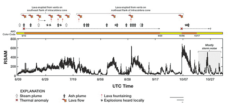 |
Figure 24. Real-time seismic amplitude (RSAM) time series from seismic station VNWF (located on the lower SW flank of Veniaminof), and significant eruptive events between 9 June and 1 November 2013. The AVO Aviation Color Code during the eruption also is shown. Courtesy of USGS/AVO (figure 25, Dixon et al., 2015). |
No further reports of activity from Veniaminof were issued until increased seismic activity began on 30 September 2015. This led AVO to increase the Color Code/Alert Level to Yellow/Advisory the next day. Occasional, clear web camera images from Perryville in the subsequent weeks showed small steam plumes rising from the intracaldera cone but no ash emissions or lava effusions. Slightly elevated levels of seismicity continued until the beginning of December. AVO downgraded the status from Yellow/Advisory to Green/Normal on 11 December 2015.
References: Dixon, J.P., Cameron, Cheryl, McGimsey, R.G., Neal, C.A., and Waythomas, Chris, 2015, 2013 Volcanic activity in Alaska - Summary of events and response of the Alaska Volcano Observatory: U.S. Geological Survey Scientific Investigations Report 2015-5110, 92 p., http://dx.doi.org/10.3133/sir20155110
Waythomas, C.F., 2013, Volcano-ice interactions during recent eruptions of Aleutian Arc volcanoes and implications for melt water generation: Eos Transactions, American Geophysical Union, Fall Meeting, abstract V34C-03.
Geological Summary. Veniaminof, on the Alaska Peninsula, is truncated by a steep-walled, 8 x 11 km, glacier-filled caldera that formed around 3,700 years ago. The caldera rim is up to 520 m high on the north, is deeply notched on the west by Cone Glacier, and is covered by an ice sheet on the south. Post-caldera vents are located along a NW-SE zone bisecting the caldera that extends 55 km from near the Bering Sea coast, across the caldera, and down the Pacific flank. Historical eruptions probably all originated from the westernmost and most prominent of two intra-caldera cones, which rises about 300 m above the surrounding icefield. The other cone is larger, and has a summit crater or caldera that may reach 2.5 km in diameter, but is more subdued and barely rises above the glacier surface.
Information Contacts: Alaska Volcano Observatory (AVO), a cooperative program of a) U.S. Geological Survey, 4200 University Drive, Anchorage, AK 99508-4667 USA (URL: http://www.avo.alaska.edu/), b) Geophysical Institute, University of Alaska, PO Box 757320, Fairbanks, AK 99775-7320, USA, and c) Alaska Division of Geological & Geophysical Surveys, 794 University Ave., Suite 200, Fairbanks, AK 99709, USA (URL: http://www.dggs.alaska.gov/); Anchorage Volcanic Ash Advisory Center (VAAC), Alaska Aviation Weather Unit, NWS NOAA US Dept. of Commerce, 6930 Sand Lake Road, Anchorage, AK 99502-1845(URL: http://www.ssd.noaa.gov/); Hawai'i Institute of Geophysics and Planetology (HIGP), MODVOLC Thermal Alerts System, School of Ocean and Earth Science and Technology (SOEST), Univ. of Hawai'i, 2525 Correa Road, Honolulu, HI 96822, USA (URL: http://modis.higp.hawaii.edu/).