Report on Bardarbunga (Iceland) — February 2017
Bulletin of the Global Volcanism Network, vol. 42, no. 2 (February 2017)
Managing Editor: Edward Venzke.
Research and preparation by Jackie Gluck.
Bardarbunga (Iceland) Monitoring data from early 2016
Please cite this report as:
Global Volcanism Program, 2017. Report on Bardarbunga (Iceland) (Venzke, E., ed.). Bulletin of the Global Volcanism Network, 42:2. Smithsonian Institution. https://doi.org/10.5479/si.GVP.BGVN201702-373030
Bardarbunga
Iceland
64.633°N, 17.516°W; summit elev. 2000 m
All times are local (unless otherwise noted)
The fissure eruption from the Bardarbunga volcanic system began on 29 August 2014 (BGVN 39:10) about 45 km NE of the subglacial caldera at what was designated the Holuhraun vent. Lava emission ended on 28 February 2015 (BGVN 40:01), after creating a lava field almost 85 km2 in size. This report includes additional information provided by the Icelandic Meterological Office and NASA's Earth Observatory. Information from a report of the Icelandic Civil Protection Scientific Advisory Board, which met on 23 June 2016 to review recent data, is included below.
A scientific team working on the Vatnajökull glacier during 3-10 June 2016 did echo soundings to examine whether changes in bedrock topography within the Bardarbunga caldera could be detected from the recent eruption. No changes in the bedrock topography were apparent. There were also no indications that meltwater was accumulating within the caldera. The 65-m-deep depression in the glacier formed during the 2014-2015 activity was getting shallower due to the flow of ice into the caldera and snow accumulation, and the depression had decreased in depth by 8 m since the previous year.
Expedition scientists also measured gas emissions at ice cauldrons (figures 13 and 14), which are formed by subglacial geothermal activity, along the caldera rim; these measurements showed little change since the previous year's expedition. Seismic data showed that accumulated moment magnitude had been increasing since mid-September 2015. A total of 51 earthquakes stronger than M3 had been registered at Bardarbunga since the end of the eruption in 2015. GPS stations showed slow movement away from the caldera.
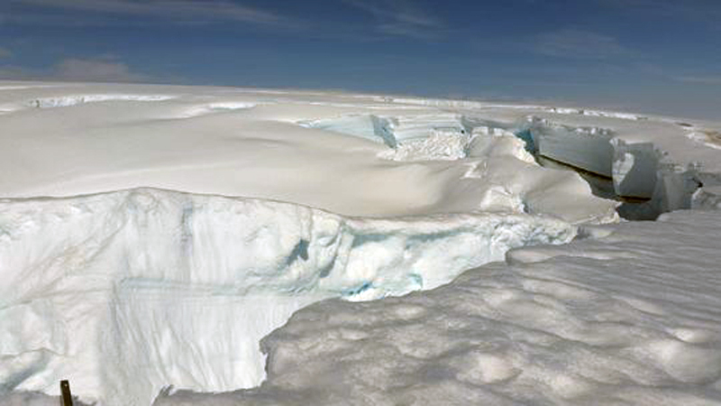 |
Figure 13. The edge of a cauldron at the southernmost rim of the Bardarbunga caldera, 10 June 2016. Photo by Benedikt G. Ófeigsson; courtesy of the IMO. |
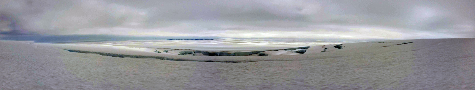 |
Figure 14. A panorama view from 7 June 2016 shows the same cauldron at Bardarbunga, with Grimsvotn in the background. Photo by Benedikt G. Ófeigsson; courtesy of the IMO. |
The Advisory Board report concluded that the most probable explanations for the ground deformation and seismicity was the inflow of magma from around 10-15 km below Bardarbunga into the area from which the magma erupted at Holuhraun during 2014-2015. There were no indications of magma collecting at shallower depths.
An image posted by the NASA Earth Observatory showed the extent of the Holuhraun lava field on 5 November 2016 surrounded by snow (figure 15).
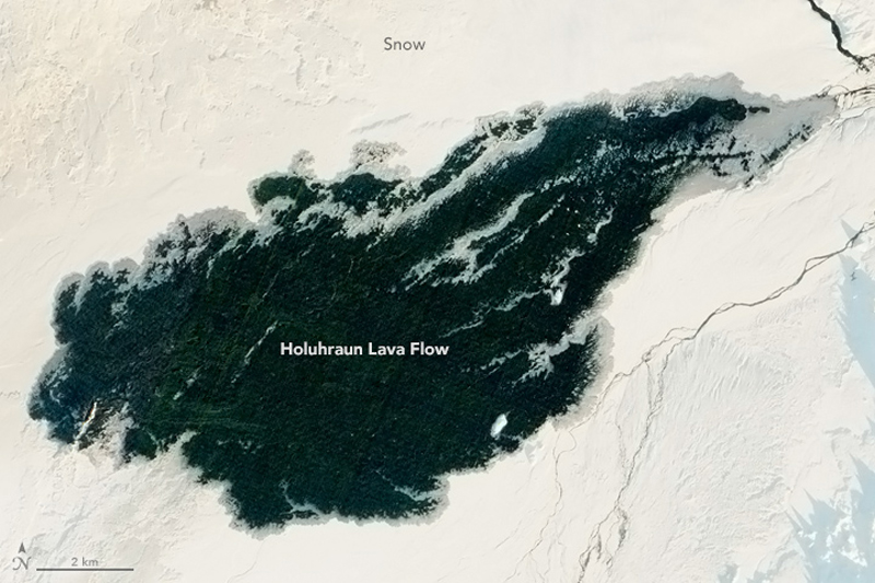 |
Figure 15. Acquired 5 November 2016, this image was captured by the Advanced Land Imager on the Earth Observing-1 satellite at 1000 local time. The photo has been edited to correct for the low angle of the Sun, which caused the white snow to appear reddish. Snow does appear to build up along the edges of the lava flow, where the lava is thinner. Courtesy NASA Earth Observatory. |
Geological Summary. The large central volcano of Bárðarbunga lies beneath the NW part of the Vatnajökull icecap, NW of Grímsvötn volcano, and contains a subglacial 700-m-deep caldera. Related fissure systems include the Veidivötn and Trollagigar fissures, which extend about 100 km SW to near Torfajökull volcano and 50 km NE to near Askja volcano, respectively. Voluminous fissure eruptions, including one at Thjorsarhraun, which produced the largest known Holocene lava flow on Earth with a volume of more than 21 km3, have occurred throughout the Holocene into historical time from the Veidivötn fissure system. The last major eruption of Veidivötn, in 1477, also produced a large tephra deposit. The subglacial Loki-Fögrufjöll volcanic system to the SW is also part of the Bárðarbunga volcanic system and contains two subglacial ridges extending from the largely subglacial Hamarinn central volcano; the Loki ridge trends to the NE and the Fögrufjöll ridge to the SW. Jökulhlaups (glacier-outburst floods) from eruptions at Bárðarbunga potentially affect drainages in all directions.
Information Contacts: Icelandic Met Office (IMO), Reykjavík, Iceland (URL: http://en.vedur.is/); NASA Earth Observatory, EOS Project Science Office, NASA Goddard Space Flight Center, Goddard, Maryland, USA (URL: http://earthobservatory.nasa.gov/).