Report on Pavlof (United States) — March 2017

Bulletin of the Global Volcanism Network, vol. 42, no. 3 (March 2017)
Managing Editor: Edward Venzke.
Edited by A. Elizabeth Crafford. Research and preparation by Robert Andrews.
Pavlof (United States) Ash plume to 11 km on 27 March 2016 that drifted 1,200 km NE; multiple smaller ash events through July 2016
Please cite this report as:
Global Volcanism Program, 2017. Report on Pavlof (United States) (Crafford, A.E., and Venzke, E., eds.). Bulletin of the Global Volcanism Network, 42:3. Smithsonian Institution. https://doi.org/10.5479/si.GVP.BGVN201703-312030
Pavlof
United States
55.417°N, 161.894°W; summit elev. 2493 m
All times are local (unless otherwise noted)
Pavlof volcano, near the end of the Alaska Peninsula 970 km SW of Anchorage, frequently produces explosive eruptions from the summit vents and occasional lava flows. The largest confirmed historical eruption took place in 1911 when a fissure opened on the N flank; it has erupted more than 25 times since then. The last reported eruption in mid-November 2014 included lava fountaining from a vent just N of the summit, and flows of rock debris and ash descending the N flank, along with an ash plume that rose to around 9 km altitude and drifted 300 km NW. Pavlof was quiet in 2015, but then abruptly renewed activity in late March 2016. It is monitored primarily by the Alaska Volcano Observatory (AVO) and the Anchorage Volcanic Ash Advisory Center (VAAC).
A sudden vigorous eruption that began on 27 March 2016 lasted for about 20 hours, sending ash to 11 km altitude, producing a plume dispersed NE for 1,200 km, and a similarly large SO2 plume. The volcano was then quiet until a short-lived, smaller ash emission occurred in mid-May for eight days. Intermittent low-level ctivity picked up again from late June through late July 2016, characterized by minor emissions of dark-colored ash and steam rising to 4.5 km altitude. Fallout of ash was limited to the flanks of the volcano and the immediate area around Pavlof. The last report of ash emissions was on 30 July, although low-amplitude tremors and steam plumes persisted through August, and intermittent thermal anomalies from the summit continued through the end of 2016.
After a short and intense eruption between 12 and 15 November 2014 (BGVN 40:04), activity decreased quickly to background levels. The AVO had reduced the Aviation Color Code (ACC) from Red (highest) to Orange on 16 November, and from Orange to Yellow on 25 November. Seismicity remained slightly above background levels until early January. On 15 January 2015 the AVO reduced the ACC to the lowest level of Green where it remained for over a year until it was changed abruptly to Red on 28 March 2016 at the start of a new eruption.
AVO reported that seismicity began to increase at 1553 on 27 March 2016, characterized by a quick onset of continuous tremor. An ash plume rose to an altitude of 6.1 km, and by 1618 was drifting N (figure 13). During the night, lava fountaining from the summit crater was observed by mariners, pilots, and residents of nearby Cold Bay (60 km SW).
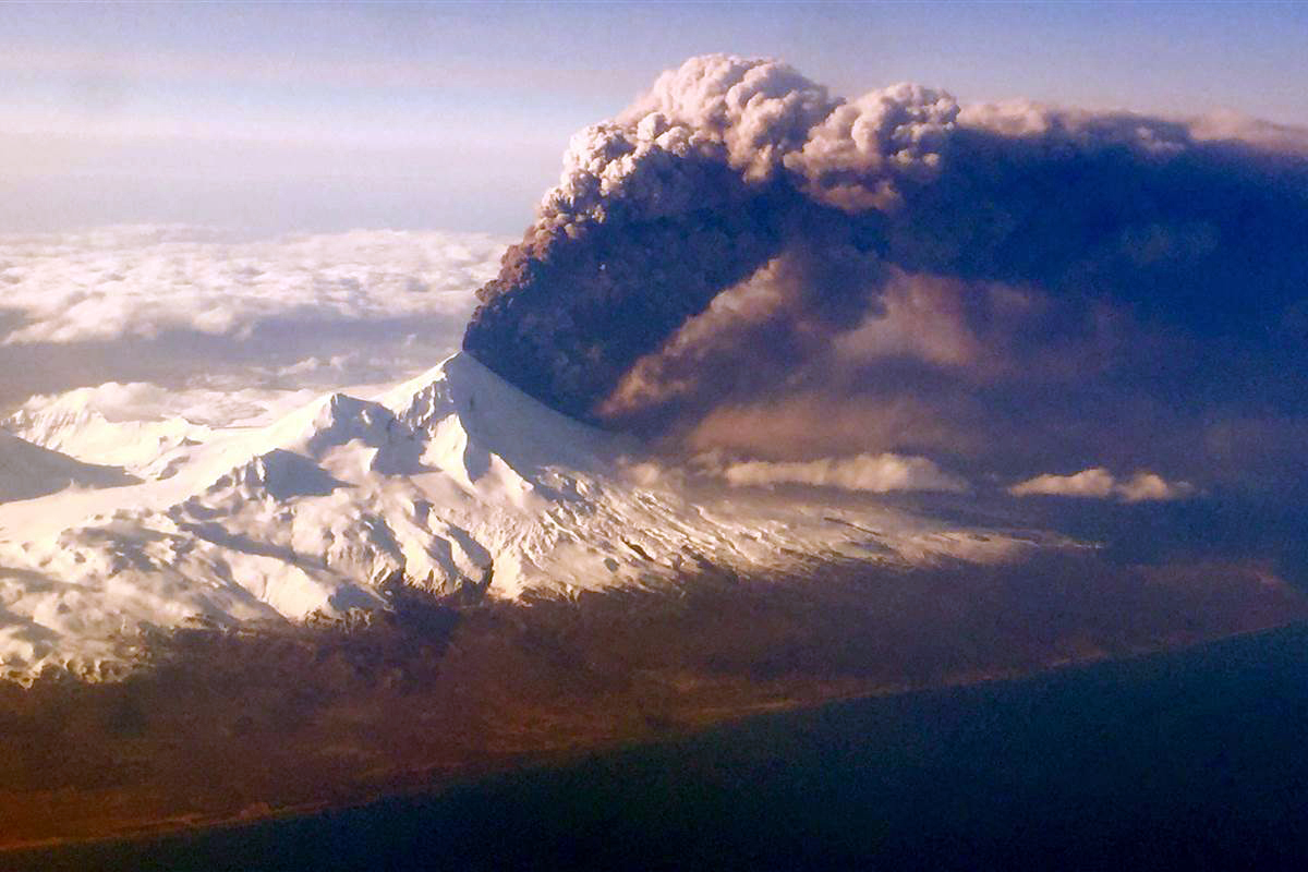 |
Figure 13. Pavlof erupts, sending a plume of volcanic ash into the air on the evening of 27 March 2016 (AKDT) as photographed by a passenger on a plane travelling to Anchorage from Dutch Harbor. Courtesy of Colt Snapp. |
On 28 March, tremor levels remained high; lightning in the ash plume was detected in the morning, and infrasound data from a sensor network in Dillingham (470 km NE) indicated sustained ash emissions. At 0700 a continuous ash plume was evident in satellite images drifting more than 650 km NE, and a MODIS image captured at midday revealed the extent and substantial thickness of the cloud (figure 14). A SIGMET (significant meteorological information notice) issued by the National Weather Service (NWS) Alaska Aviation Weather Unit indicated that the maximum ash-cloud altitude was approaching 11 km. Strongly elevated surface temperatures also suggested the presence of lava flows.
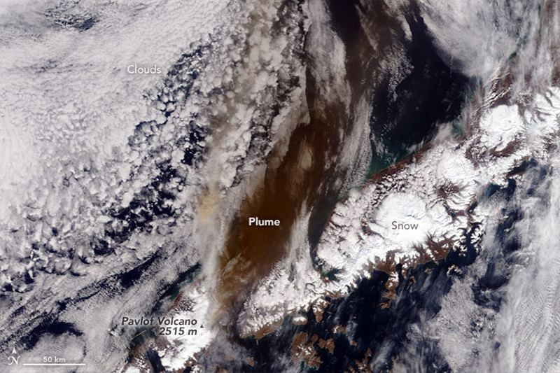 |
Figure 14. The Moderate Resolution Imaging Spectroradiometer (MODIS) instrument on a NASA satellite acquired this image of the ash plume from Pavlof at 1145 Alaska time (2145 UTC) on 28 March 2016 extending several hundred km to the NE. Courtesy of NASA Earth Observatory. |
The energetic ash-producing phase of the eruption lasted from 1600 AKDT (00:00 UTC) on 27 March until about 1230 AKDT (20:30 UTC) on 28 March, and produced an ash cloud that stretched NE over Bristol Bay and interior Alaska for over 1,200 km. As a result, over 40 Alaska Airlines flights to and from Fairbanks, Alaska, were cancelled according to NBC News. Minor ashfall (0.8 to 6.3 mm or 1/32 to 1/4 in) was reported in the nearby community of Nelson Lagoon (80 km NW) and trace ashfall (less than 0.8 mm) was confirmed near Dillingham (470 km NE). A large SO2 plume also drifted NE from the volcano extending all the way across Alaska to Yukon Territory and British Columbia in Canada (figure 15).
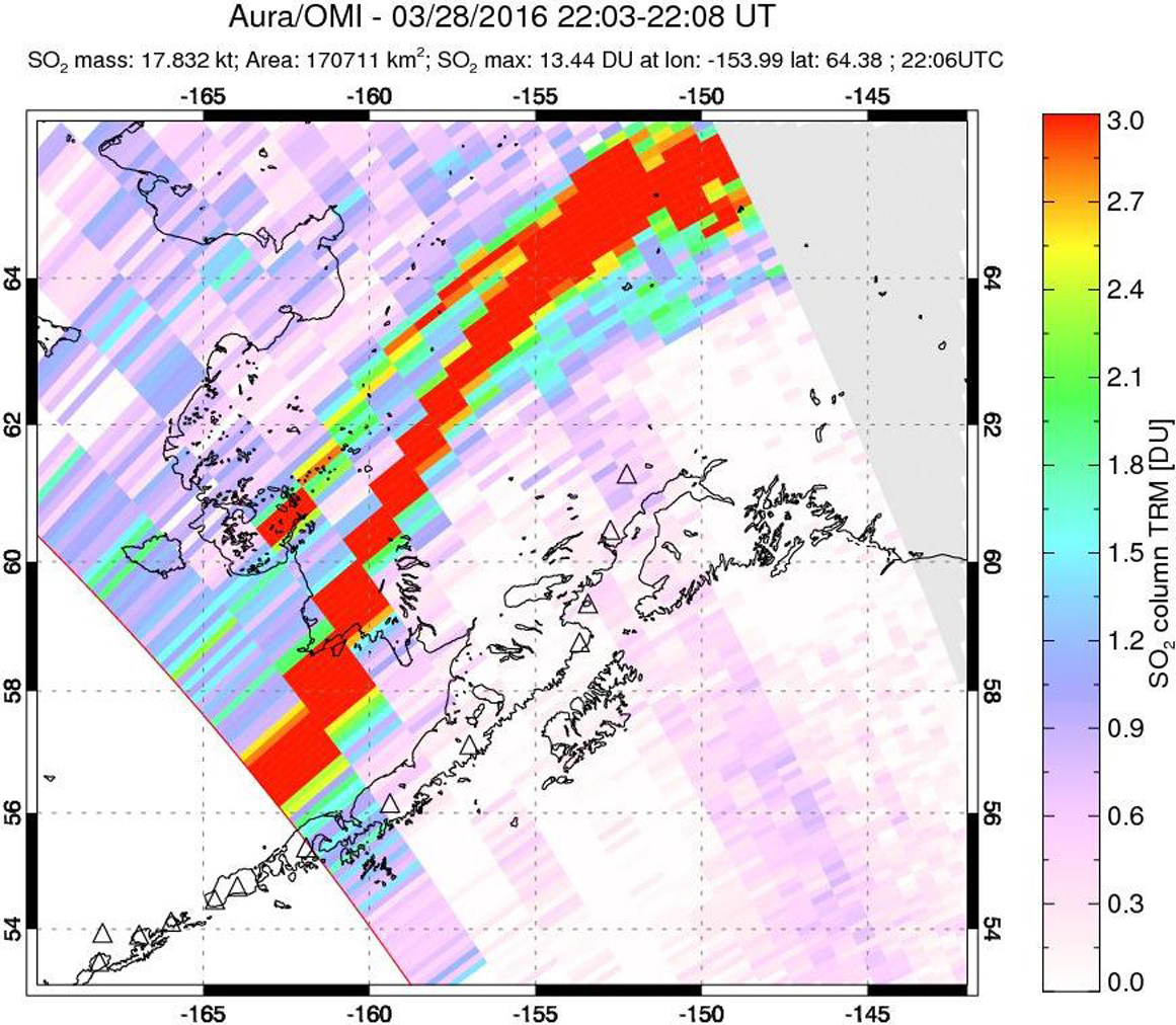 |
Figure 15. A large SO2 plume trails NE from Pavlof on 28 March 2016 after a substantial explosion sent an ash plume to nearly 12 km altitude. The ash cloud and the SO2 plume both extended for 1,200 km NE across interior Alaska. Courtesy of NASA/GSFC. |
Seismicity and infrasound signals had decreased to low enough levels by 1230 on 28 March that the AVO lowered the Aviation Color Code to Orange and the Volcano Alert Level to Watch. However, seismic tremor remained above background levels. Ash emissions decreased through the night and were barely visible in a satellite image acquired at 0625 AKDT on 29 March. Remnant ash continued to drift over Bristol Bay and areas of interior Alaska. The webcam at Cold Bay recorded intermittent, low-level ash plumes rising as high as 4.6 km.
Thermal anomalies, measured by MODIS satellite sensors and analyzed by MODVOLC, appeared from 28 March (0025 UTC) through 29 March 2016 (1360 UTC), with 20 pixels recorded on 28 March. The MIROVA system also recorded an abrupt spike to 'Very High' thermal anomaly levels on 28 March, dropping slightly in the next two days (figure 16) and then disappearing a few days later. Low-power anomalies were detected on 2 and 6 April, and then ceased for several months.
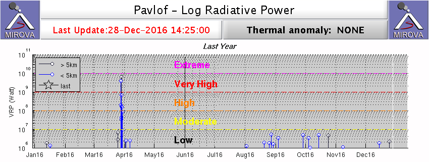 |
Figure 16. MIROVA Log Radiative Power data for Pavlof between 28 December 2015 and 28 December 2016. Note the 'Very High' level spike in Log Radiative Power during 28-30 March 2016. Values dropped significantly in early April and then disappeared for several months. Low VRP values reappeared in late August and were intermittent for the remainder of 2016. AVO determined that the summit crater was enlarged as a result of the March 2016 explosion; the new crater geometry possibly allowed satellite sensors to more easily detect emissions of hot gases from the vent. Ongoing observations of moderately elevated surface temperatures between August and December 2016 likely reflect this change in the crater, and do not indicate new eruptive activity or rising magma, according to AVO scientists. Courtesy of MIROVA. |
The AVO reported that the intensity of the eruption greatly decreased during 29-30 March, although The Canadian Press reported that ash from the eruption had caused flights in and out of Yellowknife and Regina, Canada, to be cancelled on those dates. Elevated surface temperatures identified in satellite data and visual observations of low-level, intermittent ash plumes were noted during brief breaks in poor weather conditions during these days. Airwave signals, indicative of small explosions at the summit, were recorded on 3 April, but tremors had ceased by the next day. On 6 April AVO noted no signs of ash emissions or lava effusion during the previous week, and seismicity was at low levels. Thermal anomalies at the summit were occasionally visible, though likely indicating cooling processes of previously erupted lava. AVO lowered the Aviation Color Code to Yellow and Volcano Alert Level to Advisory on 6 April. After two more weeks of no activity, the ACC was lowered to Green/Normal on 22 April 2016.
On 13 May 2016 the AVO raised the Aviation Color Code back to Orange as a result of increased seismicity typically associated with minor eruptive activity. Four minor ash eruptive episodes were inferred from seismic data between 13 and 16 May. On 14 May, local observers in Cold Bay reported ash emissions below 5 km in the vicinity of the volcano. According to the Anchorage VAAC, on 15 May a minor eruption was noted on the Cold Bay web camera, but volcanic ash was not visible in satellite data. Elevated surface temperatures were detected in satellite data on 15 May. Periods of elevated volcanic tremor and a small explosion associated with minor ash emissions was noted on 17 May; observers in Cold Bay and Sand Point (90 km E) reported ash emissions interspersed with steam emissions. The Anchorage VAAC noted that strong winds caused resuspension of volcanic ash on the lee side of Pavlof on 17 and 18 May. The AVO lowered the ACC to Yellow on 20 May and noted that all volcanic ash clouds produced during the 13-17 May event were below 4.5 km altitude, and that no lava effusion or fountaining was detected. Weak seismic tremor and small explosions were observed on 21 May, after which activity ceased. The AVO lowered the ACC to Green on 17 June.
Seismic activity increased again on 30 June for about a week, prompting the AVO to raise the ACC to Yellow on 1 July 2016; minor steam emissions were also observed in the web camera. AVO technicians installed a new web camera in the Black Hills area north of the volcano near the Bering Sea coast in early July. On 11 July, weakly elevated surface temperatures were observed at the summit in satellite imagery and a steam and gas cloud extended SW for about 80 km. Minor ash emissions reaching a few tens of meters above the summit were observed that afternoon extending a few kilometers to the SW. Small ash emissions were again observed on 18 July along with an increase in seismic tremor for about 48 hours.
On 28 July a low-intensity eruption with vigorous degassing produced a steam-rich plume and minor ash emissions. As a result, the AVO raised the ACC to Orange. The drifting steam and ash cloud was below 4.6 km above sea level and dissipated rapidly. The Anchorage VAAC reported steam and minor ash emissions continuing through 30 July.
A decline in activity led AVO to lower the ACC to Yellow on 4 August. Periods of low-amplitude tremor continued, but no plumes or thermal signals at the summit were detected. Elevated surface temperatures at the summit were observed in satellite data on 8 August, and a low-level but persistent steam plume was visible in web camera images on 11 August. A large steam plume was noted by observers in Sand Point on 15 August. Elevated surface temperatures were detected through cloud cover in satellite data on 20 and 25 August. Low-level unrest continued through the fall with persistent degassing from the summit and elevated surface temperatures detected in satellite data. A robust steam plume on 31 August reached 4.6 km, but there was no evidence of ash and it dissipated rapidly.
Several times during late September during clear views, webcam images showed a persistent steam plume from the summit crater. Elevated surface temperatures in the summit crater were observed in satellite images on 25, 28, and 29 September, and again during 4-6, 13-14, and 16 October. In early November, the AVO determined that the summit crater was larger and more centrally located than before, as a result of the March 2016 explosion. The new crater geometry possibly allowed satellite sensors to more easily detect emissions of hot gases from the vent. Ongoing observations of moderately elevated surface temperatures (figure 16) likely reflect this change in the crater, and do not indicate new eruptive activity or rising magma. Seismicity remained slightly above background levels through the end of 2016, and the ACC remained at Yellow.
Geological Summary. The most active volcano of the Aleutian arc, Pavlof is a Holocene stratovolcano that was constructed along a line of vents extending NE from the Emmons Lake caldera. Pavlof and Pavlof Sister to the NE form a dramatic pair of symmetrical, glacier-covered stratovolcanoes that overlook Pavlof and Volcano bays. Little Pavlof is a smaller cone on the SW flank of Pavlof volcano, near the rim of Emmons Lake caldera. Unlike Pavlof Sister, eruptions have frequently been reported from Pavlof, typically Strombolian to Vulcanian explosive eruptions from the summit vents and occasional lava flows. The active vents lie near the summit on the north and east sides. The largest recorded eruption took place in 1911, at the end of a 5-year-long eruptive episode, when a fissure opened on the N flank, ejecting large blocks and issuing lava flows.
Information Contacts: Alaska Volcano Observatory (AVO), a cooperative program of a) U.S. Geological Survey, 4200 University Drive, Anchorage, AK 99508-4667 USA (URL: http://www.avo.alaska.edu/), b) Geophysical Institute, University of Alaska, PO Box 757320, Fairbanks, AK 99775-7320, USA, and c) Alaska Division of Geological & Geophysical Surveys, 794 University Ave., Suite 200, Fairbanks, AK 99709, USA (URL: http://www.dggs.alaska.gov/); Anchorage Volcanic Ash Advisory Center (VAAC), Alaska Aviation Weather Unit, NWS NOAA US Dept of Commerce, 6930 Sand Lake Road, Anchorage, AK 99502-1845(URL: http://www.ssd.noaa.gov/); Hawai'i Institute of Geophysics and Planetology (HIGP), MODVOLC Thermal Alerts System, School of Ocean and Earth Science and Technology (SOEST), Univ. of Hawai'i, 2525 Correa Road, Honolulu, HI 96822, USA (URL: http://modis.higp.hawaii.edu/); MIROVA (Middle InfraRed Observation of Volcanic Activity), a collaborative project between the Universities of Turin and Florence (Italy) supported by the Centre for Volcanic Risk of the Italian Civil Protection Department (URL: http://www.mirovaweb.it/); NASA Goddard Space Flight Center (NASA/GSFC), Global Sulfur Dioxide Monitoring Page, Atmospheric Chemistry and Dynamics Laboratory, Goddard, Maryland, USA (URL: https://so2.gsfc.nasa.gov/); NASA Earth Observatory, EOS Project Science Office, NASA Goddard Space Flight Center, Goddard, Maryland, USA (URL: http://earthobservatory.nasa.gov/); Colt Snapp (URL: https://twitter.com/colt_snapp/status/714345047173369856); The Canadian Press, via Vancouver Observer (URL: http://www.vancouverobserver.com/news/environment/flights-cancelled-and-out-regina-yellowknife-after-volcano-alaska); NBC News (URL: http://www.nbcnews.com/news/weather/pavlof-volcano-erupts-covering-400-miles-alaska-ash-n546956).