Report on Kerinci (Indonesia) — April 2017
Bulletin of the Global Volcanism Network, vol. 42, no. 4 (April 2017)
Managing Editor: Edward Venzke.
Research and preparation by Paul Berger.
Kerinci (Indonesia) Brief ash eruptions in December 2011, June 2013, March-June 2016, and November 2016
Please cite this report as:
Global Volcanism Program, 2017. Report on Kerinci (Indonesia) (Venzke, E., ed.). Bulletin of the Global Volcanism Network, 42:4. Smithsonian Institution. https://doi.org/10.5479/si.GVP.BGVN201704-261170
Kerinci
Indonesia
1.697°S, 101.264°E; summit elev. 3800 m
All times are local (unless otherwise noted)
After an eruption in April 2009 (BGVN 34:12), Kerinci was quiet until it erupted again in December 2011. The Indonesian agency responsible for volcano monitoring is the Pusat Vulkanologi dan Mitigasi Bencana Geologi (PVMBG), also known as the Center for Volcanology and Geological Hazard Mitigation (CVGHM). Since mid-December 2011 there have been four instances where there was an emission of ash, qualifying the event as an eruption. These took place in December 2011, June 2013, and twice in 2016. The eruptions in 2016 were separated by five months, so are treated as distinct eruptions.
PVMBG mentioned in its 2015 reports on Kerinci that an eruption on 15 December 2011 generated an ash plume that rose about 600 m above the summit (summit elevation is 3.8 km). No other details were given.
A brief eruption was reported by PVMBG on 2 June 2013, from 0843 to 0848, that generated an ash plume 1 km above the crater. Ashfall as thick as 5 mm was reported in areas to the E, including Tangkil (7.5 km SE). In a Jakarta Post story, a resident of Sungai Rumpun village (about 10 km SE) reported hearing a loud bang and black plumes with a sulfur odor. The article noted that several villages in Gunung Tujuh district (an area that includes the SE flank of the volcano) received heavy ashfall, but it was washed off the crops by rain.
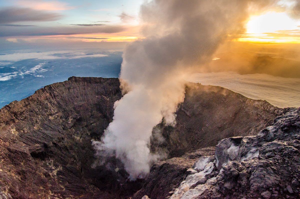
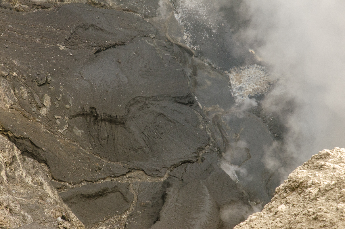
Although PVMBG reported white plumes during 1 February-12 July 2015 that rose 50-300 m and drifted E and W, no clear eruptive activity was noted. Seismicity during this period was dominated by signals indicating emissions and shallow volcanic earthquakes. Climbers who reached the summit around this time (exact dates not reported, images uploaded 17 January 2016) photographed steam plumes (figure 1) and solid lava flows (figure 2) in the crater.
 |
Figure 1. Photo of a steam plume rising from the Kerinci summit crater. Date not reported; uploaded 17 January 2016. Courtesy of Bernhard Huber. |
 |
Figure 2. Photo of the crater floor at Kerinci showing solidified lava flows and steam. Date not reported; uploaded 17 January 2016. Courtesy of Bernhard Huber. |
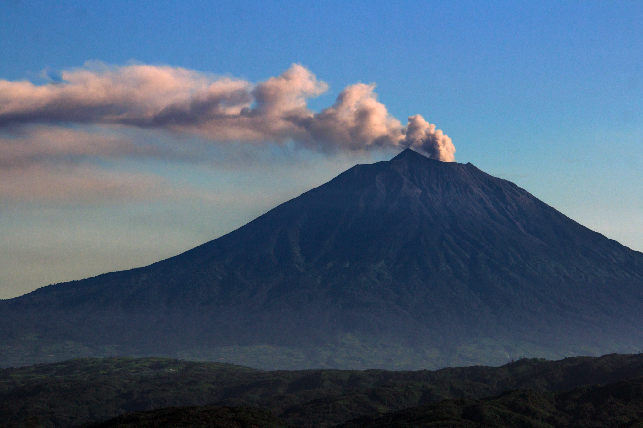
Based on satellite images and ground reports from PVMBG, the Darwin Volcanic Ash Advisory Centre (VAAC) reported that during 15 days between 31 March and 9 June 2016 ash plumes rose to altitudes of 4.0-4.9 km and drifted N, NW, NE, E, and WSW. On 29 April an ash plume rose to an altitude of 6.1 km.
 |
Figure 3. Photo of Kerinci showing a plume rising from the summit crater on 9 June 2016. Courtesy of Luke Mackin. |
Ash plumes were again reported on 15-19, and 21 November 2016 based on observations of satellite data by the Darwin VAAC. The plumes rose to altitudes of 4.3-4.6 km and drifted NE, ENE, SE, and S. On 15 and 17 November they drifted almost 30 km downwind. The Alert Level remained at 2 (on a scale of 1-4), where it has been since September 2007, and PVMBG advised residents and visitors not to enter an area within 3 km of the summit.
Geological Summary. Gunung Kerinci in central Sumatra forms Indonesia's highest volcano and is one of the most active in Sumatra. It is capped by an unvegetated young summit cone that was constructed NE of an older crater remnant. There is a deep 600-m-wide summit crater often partially filled by a small crater lake that lies on the NE crater floor, opposite the SW-rim summit. The massive 13 x 25 km wide volcano towers 2400-3300 m above surrounding plains and is elongated in a N-S direction. Frequently active, Kerinci has been the source of numerous moderate explosive eruptions since its first recorded eruption in 1838.
Information Contacts: Pusat Vulkanologi dan Mitigasi Bencana Geologi (PVMBG, also known as Indonesian Center for Volcanology and Geological Hazard Mitigation, CVGHM), Jalan Diponegoro 57, Bandung 40122, Indonesia (URL: http://www.vsi.esdm.go.id/); Darwin Volcanic Ash Advisory Centre (VAAC), Bureau of Meteorology, Northern Territory Regional Office, PO Box 40050, Casuarina, NT 0811, Australia (URL: http://www.bom.gov.au/info/vaac/); Bernhard Huber (URL: https://www.flickr.com/photos/97278656@N08/, https://creativecommons.org/licenses/by-nc-nd/2.0/); Luke Mackin (URL: https://www.flickr.com/photos/wildsumatra/, https://creativecommons.org/licenses/by-nc-sa/2.0/); Jakarta Post (URL: http://www.thejakartapost.com/news/2013/06/02/mt-kerinci-erupts.html).

