Report on Paluweh (Indonesia) — April 2017
Bulletin of the Global Volcanism Network, vol. 42, no. 4 (April 2017)
Managing Editor: Edward Venzke.
Edited by A. Elizabeth Crafford.
Paluweh (Indonesia) Two major pyroclastic flows in February and August 2013; five fatalities on 10 August 2013
Please cite this report as:
Global Volcanism Program, 2017. Report on Paluweh (Indonesia) (Crafford, A.E., and Venzke, E., eds.). Bulletin of the Global Volcanism Network, 42:4. Smithsonian Institution. https://doi.org/10.5479/si.GVP.BGVN201704-264150
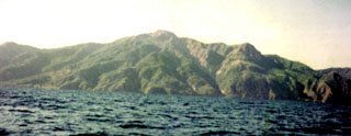
Paluweh
Indonesia
8.32°S, 121.708°E; summit elev. 875 m
All times are local (unless otherwise noted)
Mount Rokatenda, or Paluweh, on the island of Palu'e, lies north of the primary volcanic arc that cuts across Flores Island in Indonesia's Lesser Sunda Islands, and has seen infrequent activity in modern times. The previous eruption in 1985 from a summit lava dome spread 3 cm of ash over villages on the W side of the island. This report is a summary of the October 2012 to August 2013 eruption, and an update through 2016 that includes information provided by Pusat Vulkanologi dan Mitigasi Bencana Geologi (PVMBG, also known as Indonesian Center for Volcanology and Geological Hazard Mitigation, CVGHM), the Darwin Volcanic Ash Advisory Center (VAAC), and the University of Hawai'i's MODVOLC thermal alert reporting system. Numerous news reports also covered the major explosions during 2013.
Two brief periods of increased seismicity in April 2009 and January 2012 were the only recorded activity at Paluweh since 1985, prior to an eruption that began in October 2012 and continued through August 2013. PVMBG noted the beginning of lava dome growth on 8 October. A substantial number of MODVOLC thermal alert pixels from MODIS satellite data were first recorded on 11 October 2012 and recurred regularly through 20 July 2013. The first ash plumes were reported by the Darwin VAAC on 11 November 2012 and continued several times each month through May 2013, and then again in late June and during 10-12 August. Plumes generally rose to 2-3 km and drifted between 50 and 100 km in various directions, although a large ash plume on 3 February 2013 rose to higher than 13 km and drifted over 500 km SE, S and SW, briefly impacting air travel in NW Australia. A major explosion on 10 August 2013 created a large pyroclastic flow to the NW from the summit that killed five people on the beach. No further explosions were specifically dated after 12 August 2013, and seismicity gradually decreased over the next several months.
Activity during October 2012-April 2013. PVMBG noted lava dome growth, incandescent avalanches, pyroclastic flows, and ash plumes during October 2012 through January 2013. Ejecta as large as 6 cm in diameter was deposited up to 3 km from the summit, and ashfall affected the entire island, averaging 2 cm thick in places; lahars and ash damaged homes and infrastructure on the island (BGVN 39:01). A large eruption on 2 February 2013, which produced a 13-km-high ash plume the next day, generated a substantial SO2 signature, pyroclastic flows to the S and SW, and avalanches. Residents of eight villages were evacuated and significant ashfall was reported up to 1 mm thick in Ende (60 km S on East Nusa Tenggara Island). Thick ashfall was also reported in Ona (SE part of the island) and thin deposits were reported in other areas of the island to the W, N, and E. During a field expedition on 7 February, PVMBG staff observed that about 25% of the S portion of the dome was lost; the lava-dome volume had been an estimated 5.1 million cubic meters on 13 January, prior to the explosion.
After the large early February 2013 explosion, many intermittent low-level ash emissions continued through the last week in May, with over 175 VAAC reports issued from the Darwin VAAC during the period. NASA's Earth Observatory (EO) identified an ash plume in MODIS satellite images drifting over 440 km SW on 24 March 2013, and discoloration of the seawater from ash W of the island (figure 7).
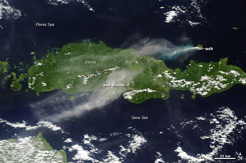 |
Figure 7. NASA image acquired 24 March 2013 with the MODIS instrument shows an ash plume from Paluweh drifting over 440 km SW across Flores Island. Light-colored ash coats the southern third of Paluweh Island, and the ocean to the W of the island is colored turquoise from ash floating near the water's surface. Courtesy of NASA, GSFC. |
Another NASA-EO image captured on 19 April 2013 shows the extent of ash deposits covering areas of the S and E sides of the summit where the plumes most commonly drift. A delta extending S into the Flores Sea, which was visible in imagery on 12 February and likely created by a pyroclastic flow during the large 2-3 February explosion (figure 8), was also visible.
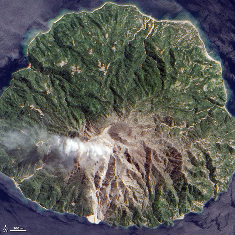 |
Figure 8. NASA-EO image of Paluweh captured 19 April 2013. Note the extent of ash covering the area of the island on the S and E sides of the summit where the plumes usually drift. It also shows a delta extending S into the Flores Sea, also visible in imagery on 12 February and likely created by a pyroclastic flow during the large 2-3 February explosion. Courtesy of NASA Earth Observatory. |
Activity during May-August 2013. There was a three-week break in reported ash plumes between 25 May and 19 June when a low level plume rising to 2.4 km was observed drifting 37 km SE. After this, no further activity was reported until 10 August. A large and deadly explosion took place on 10 August, producing an ash plume that rose to 4.3 km and drifted 130 km W. Details of the explosion are given in BGVN 39:01 and additional information is provided in this report. According to PVMBG, a substantial pyroclastic flow traveled NW from the summit down the Ojaubi drainage towards a village on the beach and killed five fisherman. Rescuers noted that the ground was hot and covered with 10-20 cm of ash. NASA-EO captured images before and after the 10 August 2013 eruption where the path of the pyroclastic flow to the NW is clearly visible (figure 9).
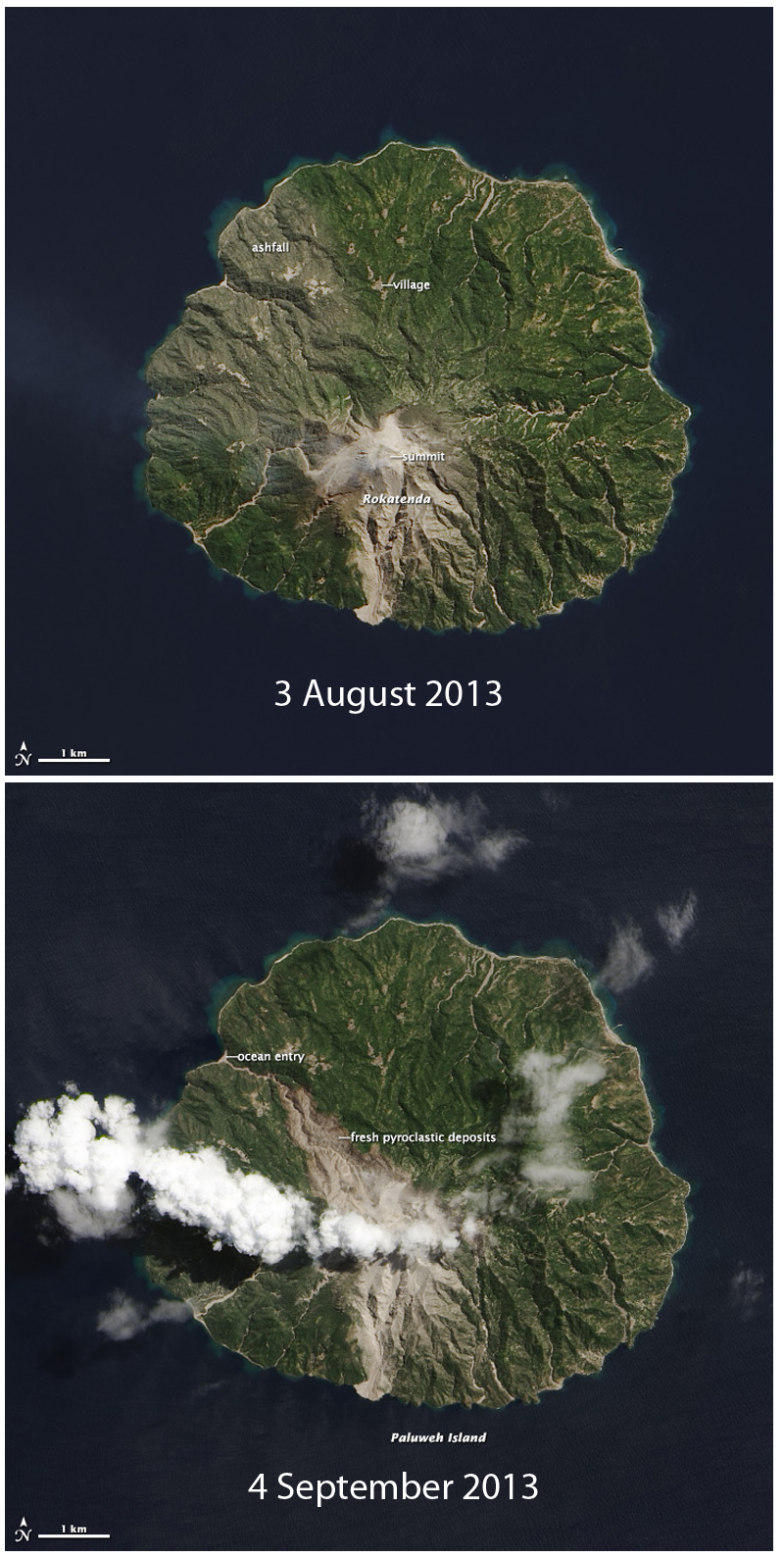 |
Figure 9. NASA-EO images of Paluweh (Mt. Rokatenda) on 3 August and 4 September 2013, before and after a large eruption with a deadly pyroclastic flow that traveled NW from the summit to the ocean, killing 5 people at the beach on 10 August. The delta on the S of the island was created during an earlier eruption and pyroclastic flow on 2-3 February 2013. Courtesy of NASA Earth Observatory. |
Activity during 2014-2016. In April 2014, PVMBG noted that the last major explosion had been on 10 August 2013. The last 2013 ash plume recorded by the Darwin VAAC was on 12 August 2013. Visual observations of occasional eruptive activity were noted until November 2013; small explosion earthquakes were also reported as being last recorded in November. No changes were observed in the lava dome between September 2013 and March 2014. PVMBG lowered the Alert level from III to II (on a scale of 1-4) on 7 April 2014.
No additional reports of activity at Paluweh appeared until late 2015, when PVMBG noted that steam plumes rising 75-200 m above the summit were common between August and October 2015. Seismicity remained low but variable during this time as well. From November 2015 through January 2016, steam plume heights ranged from 5-150 m. Seismicity remained low; earthquakes indicating rock avalanches and fumarolic emissions were the most common type recorded (figure 10). Paluweh remained quiet throughout 2016, although in February 2017 it was still listed by PVMBG at Alert Level II, with a potential for eruptive activity.
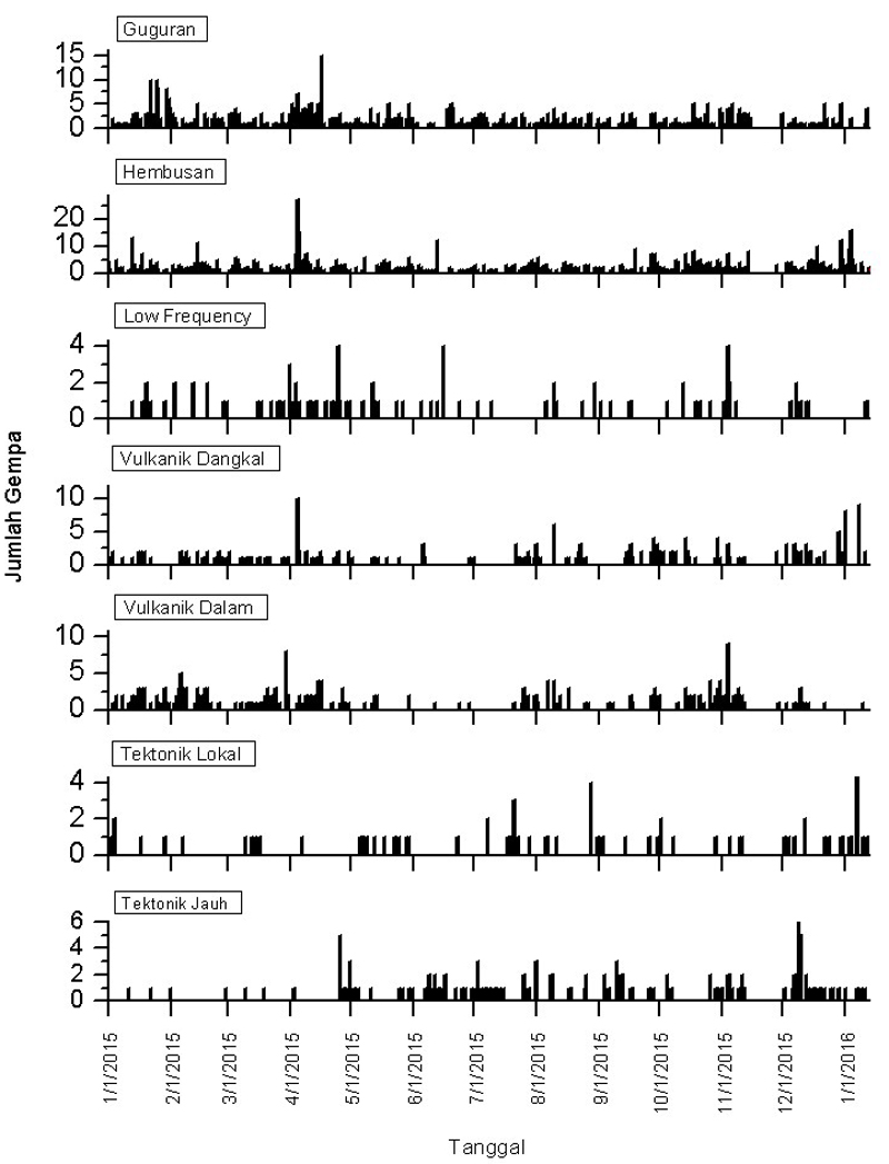 |
Figure 10. Seismic activity at Paluweh between 1 January 2015 and 13 January 2016. Vertical Axis represents daily number of events for all graphs. Guguran are avalanche events, Hembusan are emission-related events, Vulkanik Dangkal (VB) are shallow volcanic events, Vulkanik Dalam (VA) are deep volcanic events, Tektonik Local are local tectonic events, and Tektonik Jauh are distant tectonic events. Courtesy of PVMBG (Paluweh report, 18 January 2016). |
Geological Summary. Paluweh, also known as Rokatenda, forms the 8-km-wide island of Palu'e north of the volcanic arc that cuts across Flores Island. The broad irregular summit region contains overlapping craters up to 900 m wide and several lava domes. Several flank vents occur along a NW-trending fissure. A large eruption in 1928 included strong explosive activity accompanied by landslide-induced tsunamis and lava dome emplacement. Pyroclastic flows in August 2013 resulted in fatalities.
Information Contacts: Pusat Vulkanologi dan Mitigasi Bencana Geologi (PVMBG, also known as Indonesian Center for Volcanology and Geological Hazard Mitigation, CVGHM), Jalan Diponegoro 57, Bandung 40122, Indonesia (URL: http://www.vsi.esdm.go.id/); Darwin Volcanic Ash Advisory Centre (VAAC), Bureau of Meteorology, Northern Territory Regional Office, PO Box 40050, Casuarina, NT 0811, Australia (URL: http://www.bom.gov.au/info/vaac/); Hawai'i Institute of Geophysics and Planetology (HIGP), MODVOLC Thermal Alerts System, School of Ocean and Earth Science and Technology (SOEST), Univ. of Hawai'i, 2525 Correa Road, Honolulu, HI 96822, USA (URL: http://modis.higp.hawaii.edu/); NASA Earth Observatory, EOS Project Science Office, NASA Goddard Space Flight Center, Goddard, Maryland, USA (URL: http://earthobservatory.nasa.gov/).