Report on Pacaya (Guatemala) — April 2017

Bulletin of the Global Volcanism Network, vol. 42, no. 4 (April 2017)
Managing Editor: Edward Venzke.
Edited by A. Elizabeth Crafford.
Pacaya (Guatemala) Summary of 2004-2010 eruptions including a fatality in May 2010; lava flows in 2013-2014
Please cite this report as:
Global Volcanism Program, 2017. Report on Pacaya (Guatemala) (Crafford, A.E., and Venzke, E., eds.). Bulletin of the Global Volcanism Network, 42:4. Smithsonian Institution. https://doi.org/10.5479/si.GVP.BGVN201704-342110
Pacaya
Guatemala
14.382°N, 90.601°W; summit elev. 2569 m
All times are local (unless otherwise noted)
Guatemala's Pacaya volcano has a 450-year record of observations of frequent activity, in addition to confirmed radiocarbon dating of eruptions over the last 1,500 years. Its location, approximately 30 km south of the capital of Guatemala City, makes it both a popular tourist attraction as a national park, and a hazard to the several million people that live within 50 km. Activity during the last 50 years has been characterized by extensive lava flows, bomb-laden Strombolian explosions, and large and small ash plumes that have dispersed ash to cities and towns across the region.
This report summarizes activity at Pacaya during the long-lived 2004-2010 eruptive episode, and continues with the details of activity during the next eruption between March 2013 and April 2014. Most of the information is provided by the Instituto Nacional de Sismologia, Vulcanologia, Meteorologia e Hydrologia (INSIVUMEH), the Coordinadora Nacional para la Reducción de Desastres (CONRED) of Guatemala, and the Washington Volcanic Ash Advisory Center (VAAC), which provides air traffic advisories. Information is also gathered from remote sensing satellite data provided through the University of Hawai'i's MODVOLC program and from Google Earth images.
Renewed Strombolian activity was observed on 19 July 2004 after two years of mostly steam emissions, and again in early December 2004. Intermittent Strombolian explosions accompanied near-continuous lava flows down most flanks of MacKenney Cone from December until 11 September 2005. An explosion on 9 March 2006 was the beginning of a new, lengthy episode characterized by extensive lava flows and few significant ash plumes. Multiple strong thermal anomalies were recorded every month from March 2006 through June 2010, excepting December 2006. It climaxed with a major explosion of ash and lava flows during 27- 28 May 2010, and ended with the last Strombolian explosions recorded on 26 October 2010. After two and a half years of quiet, a new period of Strombolian activity began on 5 March 2013, which included intermittent lava flows. This continued until an outbreak of more extensive lava flows during the second half of January 2014. After a final burst of lava flows in early March, a small ash plume on 10 April 2014 was the last reported activity for four months.
Activity during June 2004-September 2005. Renewed periods of near-continuous tremor and frequent long-period earthquakes were recorded during June- August 2004, after the end of visible incandescence from a long-lived lava lake in June 2001. Incandescence was first reported on 14 June 2004, followed by ejection of lava fragments from a vent at the bottom of the central crater of MacKenney Cone on 19 July (BGVN 30:10). Incandescence was observed during the next few months, and tephra was expelled from the cone during 7-9 December 2004.
A sequence of substantial lava flows was first observed by INSIVUMEH in January 2005; strong thermal signatures were initially captured by MODVOLC beginning on 24 December 2004 and persisted until 28 August 2005. During this period, most of the lava flows covered the NW, N, and NE flanks of the central crater, but some extended up to 300 m down the W and SW flanks (figure 62). An INSIVUMEH report from 2008 noted that in March and April 2005 the growth of N-S oriented cracks on the MacKenney Crater created a new vent on the cone's ENE side. In just a few days, the flow field from this vent grew to about 800 m long and curved westward down the N flank, filling much of the depression formed by the cracks in the subsequent months (BGVN 33:08).
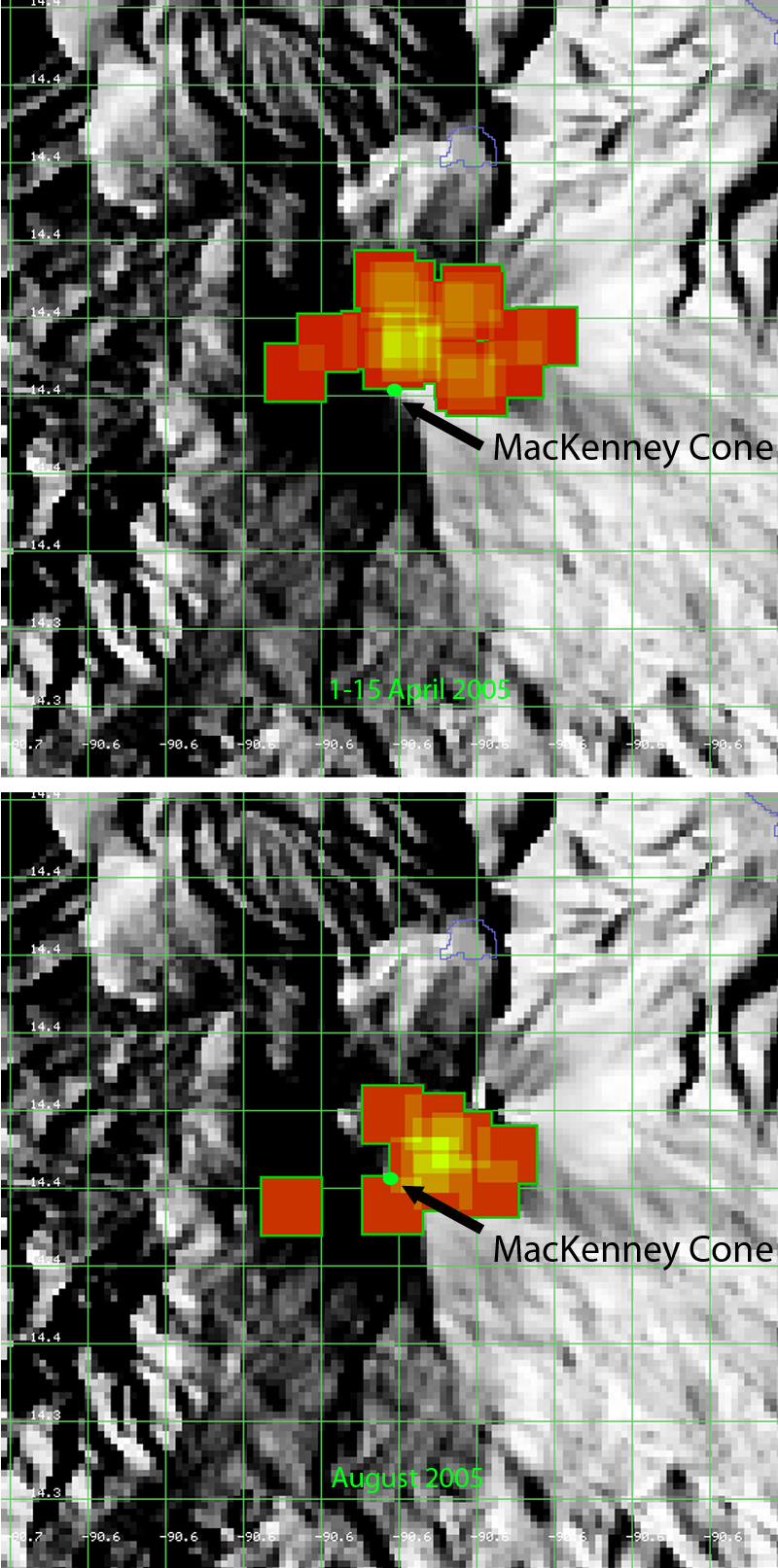 |
Figure 62. Two MODVOLC images of Pacaya showing locations of lava flows during 2005. Upper image shows lava flows during 1-15 April 2005. Flows are located NW, N, and NE of MacKenney Cone as well as to the W in a longer flow. During August 2005 (lower image), active flows were concentrated NE and E of the cone with residual cooling observed to the W and SW. Courtesy of HIGP MODVOLC Thermal Alerts System. |
Strombolian explosions reached 100 m above the crater, and avalanches of ejected incandescent blocks produced small ash clouds to low levels during much of 2005. Thermal anomalies ceased at Pacaya after 28 August 2005, although observations by INSIVUMEH of occasional Strombolian activity and ejected bombs were made until 11 September. After that, only weak incandescence was reported in early November and January 2006; a new Strombolian explosion occurred on 9 March 2006.
Activity during 2006-2009. The Strombolian explosions that began on 9 March 2006 ejected material tens of meters above the volcano in pulses of activity lasting 10-30 seconds; on 12 March material rose 250 m above MacKenney Cone. Significant lava flows began in late March, advancing about 150 m from the S and SW edges of the crater. A new flow on 13 April was reported by INSIVUMEH as issuing from a parasitic cone, at the ENE base of the main cone, and was 125 m long by 17 April. During the rest of 2006, lava flows from this vent reached lengths of more than 800 m NW of the summit cone and covered an area N, NE, and NW of the cone, known as the 'meseta' (plateau) popular with visitors to the Park (see figures 39, 40, and 41, BGVN 33:08). The Washington VAAC issued only one ash advisory in 2006, on 28 August, and noted possible ash emissions at 3 km altitude drifting 16 km W.
Throughout 2007, 2008, and 2009, multiple vigorous lava flows traveled in different directions from MacKenney Cone. The new lava flows that emerged from a vent on the ENE flank during March and April 2006 also continued to flow NE and N, and then curved to the W in multiple branches, covering large areas of the plateau between the active cone and the three older cones (Cerro Grande, Cerro Chiquito and Cerro Chino) to the N. These flows were most active through November 2008 (figure 63). Flows down the S and SW flanks continued intermittently and reached lengths of several hundred meters. They were most active between August 2008 and the end of 2009; reaching 800 m long in December 2008. Lava flow volume and explosive activity increased during April 2009; the flows traveled down the S and SW flanks for distances up to 400 m. During July, they traveled as far as 600 m down the flanks, and remained vigorous throughout the rest of the year.
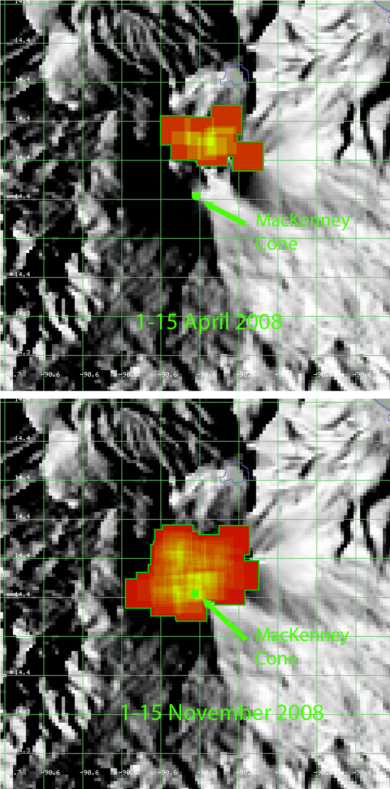 |
Figure 63. Location and extent of thermal anomalies from lava flows and Strombolian activity at Pacaya during April and November 2008. Upper image: Thermal anomalies suggest that lava flows during the first half of April 2008 were primarily issuing from a vent on the NE flank and flowing N, NW, and NE, and not originating from MacKenney Cone. Lower image: By November 2008, there were extensive flows from the summit crater flowing W and SW, as well as to areas N of the cone. Courtesy of HIGP MODVOLC Thermal Alerts System. |
Strombolian explosions were intermittent during this three year period, only reported a handful of times in January, June, and December 2007, February, May, and July 2008, and March and April 2009, with explosions of material to a few tens of meters above the summit cone. These explosions often created gas plumes reported by INSIVUMEH to altitudes of 2-3 km. They reported that material from explosions in March 2009 enlarged the cones in the summit crater, and vigorous degassing contributed to substantial noise. A small spatter cone, 4 m high, was detected in the S part of the crater in late April.
There were only three series of VAAC reports during 2007-2009, two in 2007 and one in 2008. A small ash plume was observed on 6 April 2007 at 4.6 km altitude that drifted less than 10 km SSE before dissipating. On 17 November 2007 a narrow plume was observed in satellite imagery extending 15-25 km NW of the summit at an altitude of 4.3 km. A brief emission of gas and possible ash was reported on 2 November 2008, but dissipated within three hours.
Activity during 2010. During January 2010, the lava flows that had descended the S, SW, and W flanks of MacKenney Cone since 2006 ceased flowing. Strombolian explosions were observed again in early February and new flows originating from a depression on the NE flank of the cone traveled 400 m down the E and NE flanks toward the meseta. Avalanches of blocks from the flow fronts set fire to local vegetation. Significant tephra explosions reached up to 150 m high in late February and lava flows traveled 800 m E (figure 64). Multiple lava flows on the SW flank of MacKenney cone on 20 May 2010 traveled 1.6 km, farther than previously recorded flows.
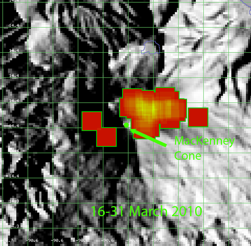 |
Figure 64. Significant new lava flows at Pacaya can be identified moving E from the NE flank of MacKenney Cone beginning in February 2010 on this map of MODVOLC thermal alerts. The flows that had been active through January to the W and SW were cooling but still produced a thermal signature visible in this MODVOLC image from the second half of March 2010. Courtesy of HIGP MODVOLC Thermal Alerts System. |
This increasing activity culminated in a large Strombolian eruption on 27 and 28 May 2010. On 29 May a 90-m-wide lava flow traveled SSE down the flank at an estimated rate of 100 m per hour and burned three houses on the Pacaya Grande ranch (see details in BGVN 39:05). The eruption was characterized in a report from CONRED as having constant explosions that ejected material 500 m into the air. INSIVUMEH reported a continuing series of explosions 5-10 seconds apart that ejected black ash up to 1 km above the crater on 28 May.
Numerous weather clouds prevented the Washington VAAC from determining an altitude of the ash plume until late on 28 May, when it was visible in satellite imagery at about 13 km altitude. Ash plumes drifted 20-30 km NW, causing ashfall as thick as 10 cm in areas downwind, including in Guatemala City, about 30 km NNE. INSIVUMEH reported 5-7 mm of ashfall during 27-28 May at the Aurora International Airport. CONRED reported on 28 May that about 1,600 people had been evacuated from six towns 3-4 km W, NNW, N, and NNE, and that the airport was closed. According to a map posted by CONRED, blocks fell in areas as far as 12 km NE, and ash was reported in areas E of Chinautla, 37 km NNE. Reuters News Agency reported that one person (a reporter) died and three children were missing.
The lava flow moving down the SSE flank of MacKenney Cone was shown by MODVOLC thermal alert pixels that persisted through much of June 2010 (figure 65). The lava flowed to within 450 m of several properties including El Chupadero, located 2-2.5 km S of the crater, and disrupted an access road from El Caracol (3 km SW) and Los Pocitos (5.5 km S).
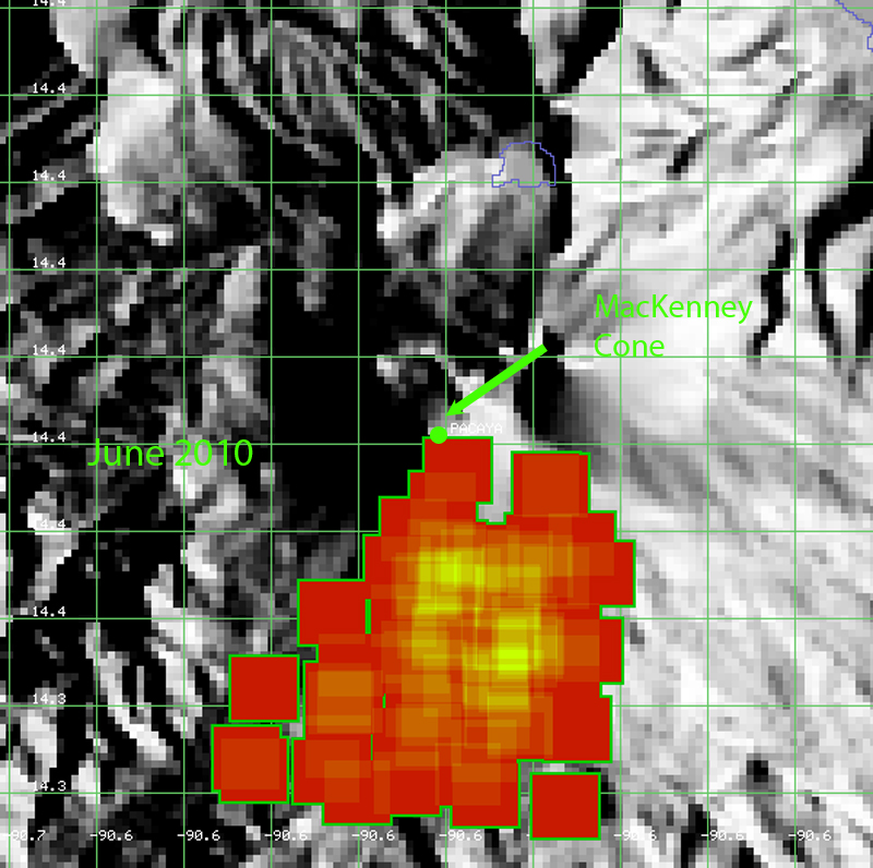 |
Figure 65. Thermal alert pixels seen in MODVOLC data show the area of lava flows at Pacaya extending down the SSE flank of MacKenney Cone from the summit and from a vent on the SSE side of the cone during June 2010, damaging property in its path. Courtesy of HIGP MODVOLC Thermal Alerts System. |
Intermittent Strombolian activity continued into June 2010, with tephra ejected as high as 700 m above the crater. The lava flows on the SE flank remained active through mid-June and had traveled as far as 3.5 km before cooling. By late June, the cone was primarily emitting white and blue fumarolic plumes to several hundred meters. Significant ash emissions and small pyroclastic flows were again reported during the last two weeks of July, causing an evacuation of 150 people from nearby areas. A Washington VAAC report on 22 July noted a plume at an altitude of 4.1 km drifting N, that produced ashfall within 10 km. Strombolian explosions on 24 and 25 July were strong enough to cause a MODVOLC thermal alert pixel at the summit, and to eject tephra blocks onto the flanks.
The last eruptive events of this multi-year eruption were ash plumes emitted in August and Strombolian activity in October 2010. Small ash plumes rose to 800 m above the crater causing ashfall 5 km away on 2 and 3 August. This was followed by a burst of Strombolian explosions during 21-22 and 26 October. After this, only fumarolic emissions of primarily water vapor were reported at Pacaya until a plume of ash-and-gas was reported by INSIVUMEH on 5 March 2013.
A comparison of a geologic map prepared by INSIVUMEH's Rudiger Escobar Wolf in 2010 (also published in BGVN 39:05) and a Google Earth image from December 2010 readily shows the impact of the extensive flows at Pacaya during the 2006-2010 eruptive episode (figure 66).
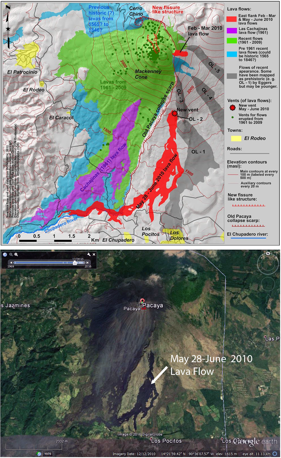 |
Figure 66. Comparison of 2010 geologic map (also published in BGVN 39:05) and a Google Earth image dated 12 December 2010 showing the impact of the lava flows at Pacaya from the 2006-2010 eruption. Geologic map from INSIVUMEH, imagery from Google Earth. |
Activity during March 2013-August 2014. Pacaya remained quiet between October 2010 and March 2013 except for intermittent pulses of seismicity and minor water vapor and gas emissions. An increase in explosions was noted beginning late in 2012, but only steam plumes were observed rising less than 500 m above the summit during January and February 2013. A single MODVOLC thermal alert pixel captured on 2 Feb 2013 to the SE of MacKenney Cone is likely the result of agricultural, not volcanic, activity.
The first report of renewed activity was on 5 March 2013 when INSIVUMEH noted that a thin plume of brown ash accompanied the fumarolic plumes, and dispersed to the S. Weak gas-and-ash plumes recurred several more times during March. On 24 April tephra was ejected 25 m high by weak explosions; incandescence and explosions were detected the next day and again on 29 April. Incandescence was regularly observed during May, and more substantial Strombolian activity started on 20 May and carried through to the end of the month. Tephra ejections rose to 25 m above the crater, and continuous explosions a few minutes apart that ejected bombs and generated rumbles, were heard 4 km away. An explosion on 30 May ejected ash and lapilli 200 m above the crater that was then deposited within 400 m of the crater.
Strombolian activity on 27 June 2013 again ejected small amounts of tephra that were deposited on the W flank. An investigation of the summit crater of MacKenney Cone during June determined that a 15 m high cone had been the source of the most recent explosive activity. An increase in seismicity in late July indicated the continued growth of the pyroclastic cone which had risen to 4 m above the crater rim by 24 July, doubling its total height from June to more than 30 m high. Weak explosions and incandescence were observed the next night, and a Strombolian eruption on 30 July lasted for four hours and ejected material 250 m above the cone. A diffuse ash plume drifted 2 km N, causing ashfall in areas downwind, and another ash plume drifted 5 km S. A prominent hot spot at the summit was reported by the Washington VAAC.
During 9 and 10 August seismicity increased again and Strombolian explosions ejected tephra 200 m above MacKenney Crater and onto the flanks, 400 m from the crater, causing small avalanches on the flanks. Another explosion during the night of 14-15 August produced a 300-m-long lava flow that traveled W from MacKenney Crater; new emissions of ash and gases to 500 m above the crater were reported by the Washington VAAC the next day. Tremors and explosions of incandescent material continued through August and the first half of September ejecting material and sending small ash plumes a few kilometers above the cone. Incandescence was reported as visible from the capital to the N by mid-September. Two MODVOLC thermal anomaly pixels were recorded on 30 August and 3 September confirming the increased thermal activity reported by INSIVUMEH.
In late November 2013 INSIVUMEH reported that activity remained unchanged with weak explosions, gas emissions and tephra ejections continuing. Pilots reported that ash plumes rose to 2.7 km and drifted 10 km SW. This continued into early January 2014 when activity at the main crater increased; seismographs recorded constant tremor, and beginning on 11 January, INSIVUMEH observed tephra explosions to 100 m, gas plumes to 600 m, and new craters on the E, S, and W flanks that produced extensive new lava flows. These flows emitted strong thermal anomaly signatures that were captured by MODVOLC for the next two weeks (figure 67).
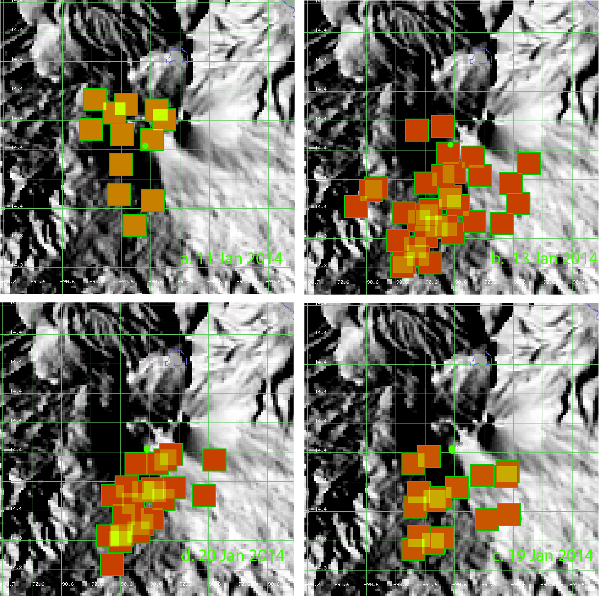 |
Figure 67. MODVOLC thermal alert images from Pacaya on individual days during January 2014 show the extent of new lava from multiple vents on the E, S, and W flanks of MacKenney Cone. The green dot is the summit crater at MacKenney Cone. Clockwise from top left: a) 11 January, thermal signatures N and SW of the summit crater; b) 13 January, the strongest signals are from the SW and SW flanks; c) 19 January, fewer signals suggest a pause in the flows; d) 20 January, renewed flows on the S flank. Courtesy of HIGP MODVOLC Thermal Alerts System. |
At the beginning of this event (on 11 January) CONRED reported evacuations from Villa Canales (14 km NW), El Chupadero (2-2.5 km S), and San Vicente Pacaya (5 km NW). Lava flows had reached 3 km by 13 January. A report on 21 January noted that the S-flank lava flow was 3.6 km long and continued to slowly advance, burning vegetation (figure 68) between the Rodeo and Los Pocitos roads.
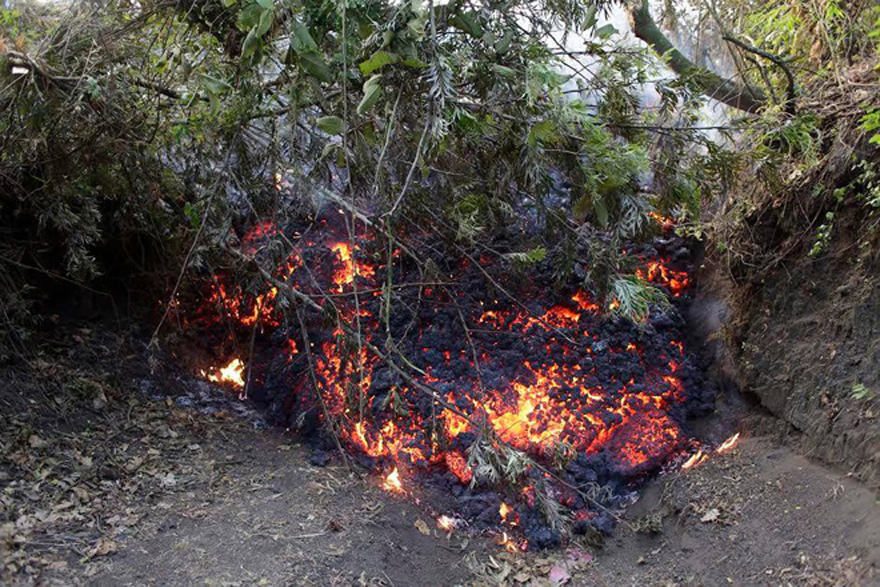 |
Figure 68. An a'a lava flow at Pacaya burning its way through a forest on 11 January 2014. Courtesy of CONRED. |
Volcanologists observed that the cone in MacKenney Crater had been completely destroyed during the January events, leaving a deep crater that produced fumarolic activity. The Washington VAAC noted an ash plume on 11 January that rose to 3.4 km and extended 55 km SSW from the summit. After that, a prominent hot spot was visible but there was no further indication of ash in satellite imagery. Separate Google Earth images captured in December 2013 and April 2014 show the extent of the new lava flows on the S flank of MacKenney Cone (figure 69) during January 2014.
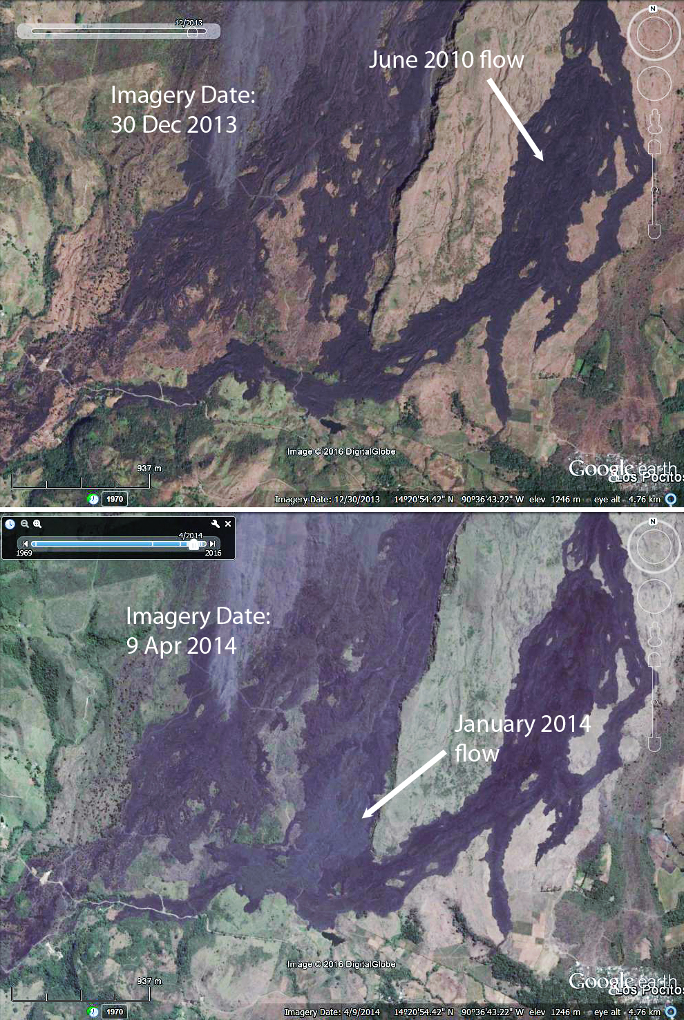 |
Figure 69. Two Google Earth images of the S flank of MacKenney Cone at Pacaya before and after lava flows during January 2014. Upper image is dated 30 December 2013. Lower image is dated 9 April 2014. An image dated 30 March also shows the new flows, but was much hazier. Note that the location of MODVOLC thermal alerts in figure 67d matches the location of January 2014 lava flows. Courtesy of Google Earth. |
The next episode of activity began with increased gas-and-vapor plumes during 27-28 February 2014 and included ejection of fine pyroclastic material 600 m S and SW from the crater. INSIVUMEH and CONRED noted increased activity on 2 March; at 0515 Strombolian activity at MacKenney Crater ejected material as high as 800 m and lava flows descended the W flank (figure 70). Explosions produced dense ash plumes that initially rose 2.5 km and drifted 15 km S, SW, and W. Ashfall was reported in El Rodeo (4 km WSW), Patrocinio (about 5 km W), and Francisco de Sales (5 km N). By the next day, activity had decreased, but lava flows traveled up to 1.3 km S and ejected tephra drifted 600 m S and SW. Small explosions and lava flows continued to be active for the next week. MODVOLC thermal alerts were captured around the summit on 2 and 3 March, but no additional thermal alerts were recorded in 2014. The Washington VAAC also noted emissions of gas and volcanic ash on 2 March that rose to 4.9 km altitude and extended over 200 km W before the end of the day. By 3 March an area of light ash remained 370 km W of the volcano off the southern Mexico coast and dissipated during the day.
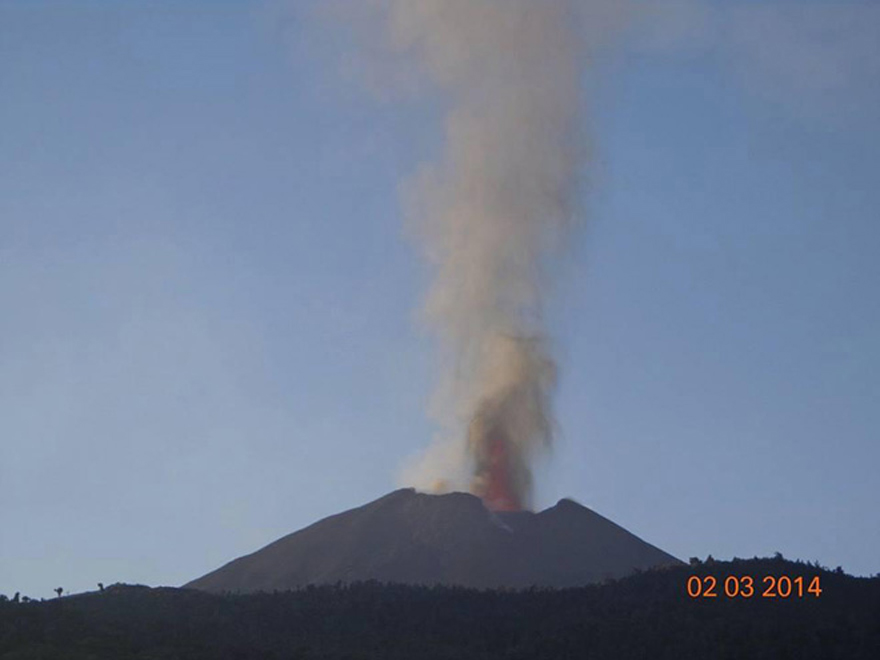 |
Figure 70. The eruption of Pacaya on 2 March 2014. The lava fountain (reddish) can be seen at the summit vent. Courtesy of CONRED. |
After INSIVUMEH reported a small ash plume on 10 April 2014, only minor episodes of increased seismicity and steam plumes rising a few tens of meters above the summit were observed through August.
Geological Summary. Eruptions from Pacaya are frequently visible from Guatemala City, the nation's capital. This complex basaltic volcano was constructed just outside the southern topographic rim of the 14 x 16 km Pleistocene Amatitlán caldera. A cluster of dacitic lava domes occupies the southern caldera floor. The post-caldera Pacaya massif includes the older Pacaya Viejo and Cerro Grande stratovolcanoes and the currently active Mackenney stratovolcano. Collapse of Pacaya Viejo between 600 and 1,500 years ago produced a debris-avalanche deposit that extends 25 km onto the Pacific coastal plain and left an arcuate scarp inside which the modern Pacaya volcano (Mackenney cone) grew. The NW-flank Cerro Chino crater was last active in the 19th century. During the past several decades, activity has consisted of frequent Strombolian eruptions with intermittent lava flow extrusion that has partially filled in the caldera moat and covered the flanks of Mackenney cone, punctuated by occasional larger explosive eruptions that partially destroy the summit.
Information Contacts: Instituto Nacional de Sismologia, Vulcanologia, Meteorologia e Hydrologia (INSIVUMEH), Unit of Volcanology, Geologic Department of Investigation and Services, 7a Av. 14-57, Zona 13, Guatemala City, Guatemala (URL: http://www.insivumeh.gob.gt/); Coordinadora Nacional para la Reducción de Desastres (CONRED), Av. Hincapié 21-72, Zona 13, Guatemala City, Guatemala (URL: http://conred.gob.gt/www/index.php); Washington Volcanic Ash Advisory Center (VAAC), Satellite Analysis Branch (SAB), NOAA/NESDIS OSPO, NOAA Science Center Room 401, 5200 Auth Rd, Camp Springs, MD 20746, USA (URL: http://www.ospo.noaa.gov/Products/atmosphere/vaac/, archive at: http://www.ssd.noaa.gov/VAAC/archive.html); Hawai'i Institute of Geophysics and Planetology (HIGP), MODVOLC Thermal Alerts System, School of Ocean and Earth Science and Technology (SOEST), Univ. of Hawai'i, 2525 Correa Road, Honolulu, HI 96822, USA (URL: http://modis.higp.hawaii.edu/); Google Earth (URL: https://www.google.com/earth/); Reuters News Agency (URL: http://www.reuters.com/article/us-guatemala-volcano-idUSTRE64R11M20100528?pageNumber=2).