Report on Whakaari/White Island (New Zealand) — May 2017

Bulletin of the Global Volcanism Network, vol. 42, no. 5 (May 2017)
Managing Editor: Edward Venzke.
Research and preparation by Robert Andrews.
Whakaari/White Island (New Zealand) Ongoing unrest, with phreatic activity on 27 April and 13 September 2016
Please cite this report as:
Global Volcanism Program, 2017. Report on Whakaari/White Island (New Zealand) (Venzke, E., ed.). Bulletin of the Global Volcanism Network, 42:5. Smithsonian Institution. https://doi.org/10.5479/si.GVP.BGVN201705-241040
Whakaari/White Island
New Zealand
37.52°S, 177.18°E; summit elev. 294 m
All times are local (unless otherwise noted)
Following a period with frequent eruptions between 1995 and 2001, White Island (officially called Whakaari/White Island) was quiet until 2012, when plumes began rising from the crater lake on 5 August that included ash two days later (BGVN 37:06). Hydrothermal activity was vigorous, generating phreatic explosions and ash emissions through July 2013, followed by larger explosions in August and October (BGVN 39:02). No further eruptive activity was observed until 2016, when brief phreatic explosions took place on 27 April and 13 September. Monitoring by GNS Science is conducted under the GeoNet Project, the official source of geological hazard information in New Zealand. The following information comes from the GeoNet website.
GNS scientists visited in early February 2014 and measured the crater lake temperature of 57°C and that of fumarole F0, on the S part of the crater floor, at 147°C. The lake level was still rising, and had drowned one of the fumaroles on the southern lakeshore, causing occasional geysering in that area. A new Global Positioning System (GPS) station was installed on the crater floor to strengthen the deformation monitoring network. The average SO2 gas flux remained below 500 metric tons per day; this was lower than the previous few months and may have been partly due to the higher lake level. On 28 August 2014 the GeoNet seismic network detected a sequence of small earthquakes near White Island, the largest event was magnitude 3.3 and located within 5 km of the island. All the quakes were shallow (less than 10 km depth).
Monitoring by plane, ground instruments, and visual observation throughout 2015 indicated that minor volcanic unrest continued. In October 2015, GNS Science volcanologists measured such factors are ground deformation, CO2 soil gas, fumarole and crater lake temperature, lake level, and SO2 gas. Seismometers continued to monitor volcanic tremors, and airborne monitoring measured CO2, SO2, and H2S levels. Elevated amounts of CO2 emitted from one of the large accessible fumaroles was detected on 1 October; temperatures and SO2 emissions also increased. On 8 October volcanic tremor magnitude strengthened and became banded (the signal disappeared and reappeared every few hours), commonly noted during periods on unrest and eruptive periods.
Over two weeks in mid-April 2016 the lake level dropped by 2 m. Then, on the morning of 27 April, a brief eruption occurred (lasting about 90 minutes) accompanied by moderately elevated seismic activity. The eruption appears to have deposited material over the N side of the crater floor and up onto the N crater wall. The Volcanic Alert Level was raised to 3 (minor volcanic eruption) and the Aviation Colour Code (ACC) changed from Green to Orange. A subsequent lack of activity resulted in a lowering of the Volcanic Alert Level to 2 (moderate to heightened volcanic unrest) that evening. Observers who flew over the volcano the following day saw a dark-green ash covering at least 80% of the crater floor and up the sides of the crater wall on both N and S sides; the deposit was ~5 mm thick at a distance of 500 m from the eruption site (figure 65).
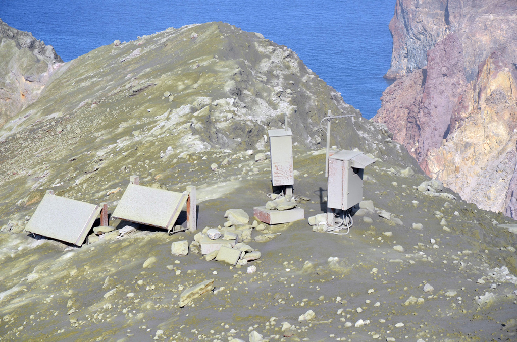 |
Figure 65. Ash from the White Island eruption on 27 April 2016 covering the monitoring station. Courtesy of GeoNet (Volcanic Alert Bulletin WI 2016/02). |
An aerial inspection two days after the eruption revealed a new crater and vent in the NE corner of the 1978/1990 crater complex. Analysis of the deposit showed the ash to be strongly hydrothermally altered old rock; no evidence of new, juvenile lava was found, suggesting that the eruption was likely driven by steam and gas, like the eruptions in 2012 and 2013. The eruption did produce very energetic blasts and surges that broke survey pegs at ground level. The eruption sequence, as reported by GNS, was that the area around Donald Duck Crater collapsed and exploded (figure 66), then the former lake and sediments erupted, resulting in the blast and surge deposits. The lake floor dropped at least 13 m, and there was a collapse of the 1978/90 Crater walls.
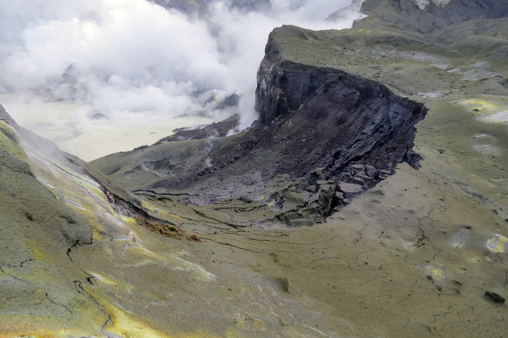 |
Figure 66. Collapsed area in Donald Duck Crater at White Island as a result of the 27 April 2016 eruption. Courtesy of GeoNet (Volcanic Alert Bulletin WI 2016/07). |
By 2 May, observations indicated no change in volcanic activity. As a consequence, the ACC was lowered to Yellow, and by 9 May the Volcanic Alert Level was lowered to 1. Although the April activity was a moderate steam and gas eruption, it did result in a new vent and ash deposits.
GeoNet reported that in the morning of 13 September 2016 a vent on the 2012 lava dome had a minor passive ash emission. The Volcanic Alert Level was raised to 3 from 1, and the ACC was changed from Green to Orange. Observations from a visit on 14 September found that the ash emissions had ceased; the Volcanic Alert Level was lowered to 2 and the ACC lowered to Yellow. The Alert Level was lowered to 1 on 19 September. The crater lake water level began to drop on 24 September, and by 26 September the lake was gone.
GNS has been using Unmanned Aerial Vehicles (UAV's; also known as drones), to monitor the volcano. In December 2016 the drone was used to obtain images of the active crater area, resulting in a new Digital Terrain Model (DTM) of the area (figure 67).
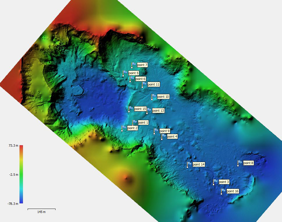 |
Figure 67. Digital Terrain Model of the White Island volcano crater floor as of December 2016. Courtesy of Geonet (Volcanic Alert Bulletin of December 2016). |
According to a GeoNet report on 3 April 2017, visits to White Island over the previous 3-4 months confirmed that activity remained at low levels. Activity was confined to the gas-rich vents on the western side of the active crater. Hot, clear gas continued to be emitted. Some water had ponded on the floor of the active crater but no permanent lake had reformed. The seismic and acoustic activity generally remain low, and the SO2 gas flux was slowly declining (figures 68 and 69).
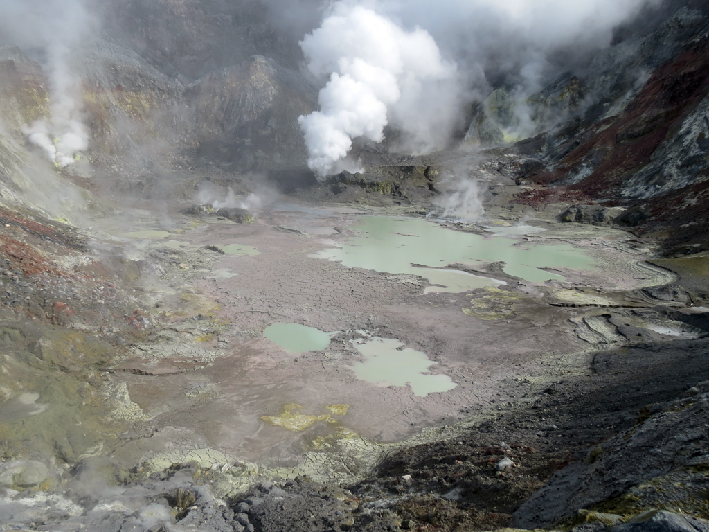 |
Figure 68. View of the active crater area of White Island in early 2017. Note the gas vent (center-rear) and ponded rainwater. Courtesy of GeoNet (Volcanic Alert Bulletin WI-2017-01, 3 April 2017). |
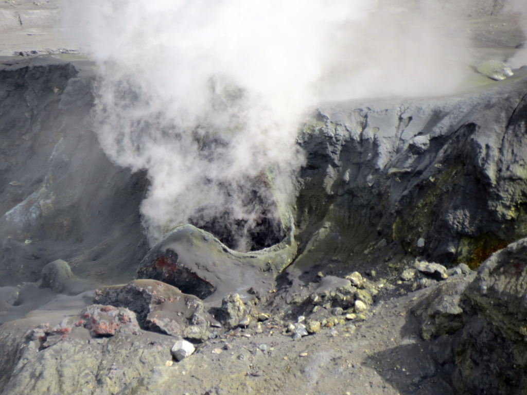 |
Figure 69. Close up view of a gas vent in the active vent area of White Island in early 2017. Courtesy of GeoNet (Volcanic Alert Bulletin WI-2017-01, 3 April 2017). |
Geological Summary. The uninhabited Whakaari/White Island is the 2 x 2.4 km emergent summit of a 16 x 18 km submarine volcano in the Bay of Plenty about 50 km offshore of North Island. The island consists of two overlapping andesitic-to-dacitic stratovolcanoes. The SE side of the crater is open at sea level, with the recent activity centered about 1 km from the shore close to the rear crater wall. Volckner Rocks, sea stacks that are remnants of a lava dome, lie 5 km NW. Descriptions of volcanism since 1826 have included intermittent moderate phreatic, phreatomagmatic, and Strombolian eruptions; activity there also forms a prominent part of Maori legends. The formation of many new vents during the 19th and 20th centuries caused rapid changes in crater floor topography. Collapse of the crater wall in 1914 produced a debris avalanche that buried buildings and workers at a sulfur-mining project. Explosive activity in December 2019 took place while tourists were present, resulting in many fatalities. The official government name Whakaari/White Island is a combination of the full Maori name of Te Puia o Whakaari ("The Dramatic Volcano") and White Island (referencing the constant steam plume) given by Captain James Cook in 1769.
Information Contacts: New Zealand GeoNet Project, a collaboration between the Earthquake Commission and GNS Science, Wairakei Research Centre, Private Bag 2000, Taupo 3352, New Zealand (URL: http://www.geonet.org.nz/).