Report on Ambrym (Vanuatu) — May 2017
Bulletin of the Global Volcanism Network, vol. 42, no. 5 (May 2017)
Managing Editor: Edward Venzke.
Research and preparation by Robert Andrews.
Ambrym (Vanuatu) Occasional low-level ash emissions; lava lakes in Benbow and Marum craters active into April 2017
Please cite this report as:
Global Volcanism Program, 2017. Report on Ambrym (Vanuatu) (Venzke, E., ed.). Bulletin of the Global Volcanism Network, 42:5. Smithsonian Institution. https://doi.org/10.5479/si.GVP.BGVN201705-257040
Ambrym
Vanuatu
16.25°S, 168.12°E; summit elev. 1334 m
All times are local (unless otherwise noted)
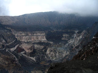
Ambrym, a volcanic island in the archipelago of Vanuatu with a large caldera (figure 35) is frequently active. Since at least 2001 the caldera has been the site of two lava lakes (BGVN 29:06, 32:05, and 40:06). The Vanuatu Geohazards Observatory (VGO) is responsible for monitoring the volcano, and the Wellington Volcanic Ash Advisory Center (VAAC) tracks ash plumes to provide aviation warnings.
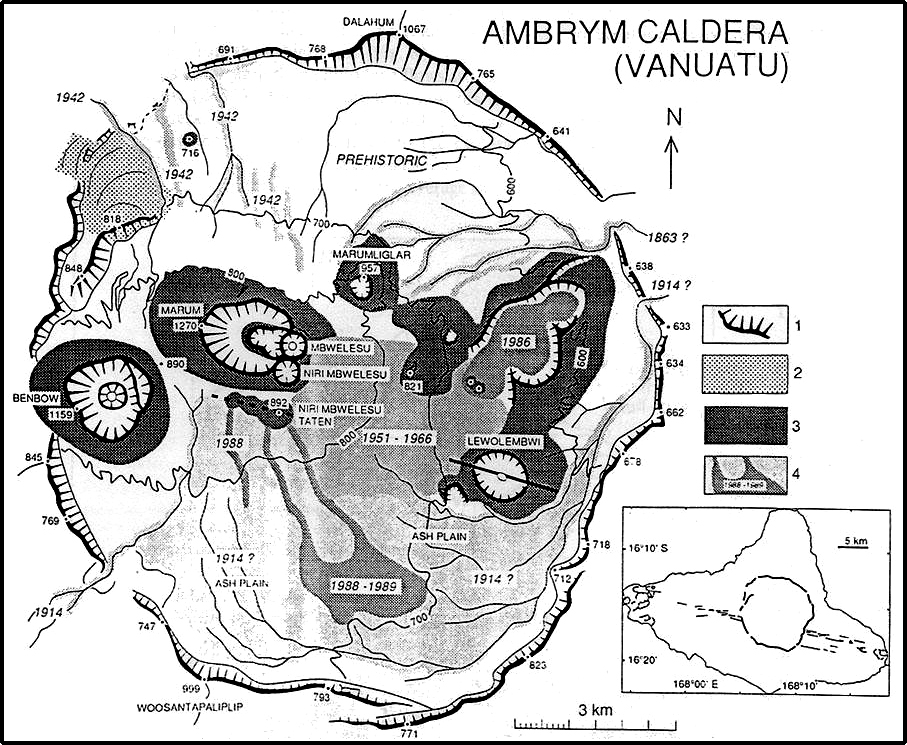 |
Figure 35. Map of the Ambrym caldera showing features and lava flows through 1989. The insert shows an outline of the island with a fracture zone passing through an outline of the circular caldera in the center of the triangular island. Courtesy of Stromboli Online; original source unknown. |
On 21 February 2015 the VGO issued a notice reminding the public that a minor eruption was occurring from a new vent inside the caldera. The Alert Level was raised from 2 to 3 (on a new scale of 0-5; see figure 30 in BGVN 40:06). Hazardous areas were near and around the active vents (Benbow, Maben-Mbwelesu, Niri-Mbwelesu and Mbwelesu), and downwind areas prone to ashfall. VGO reported both on 2 March 2015 and 27 May 2016 that activity at Ambrym had slightly decreased but remained elevated. The Alert Level was lowered to 2. Areas deemed hazardous were near and around the active vents, and in downwind areas prone to ashfall.
The Wellington VAAC reported that low-level ash emissions from Ambrym were identified in satellite images on 12 July 2016, 11-13 October 2016, and 3 April 2017. MODIS satellite thermal sensors have measured nearly continuous thermal anomalies over the past year ending in mid-April 2017, evident in both MIROVA (figure 36) and MODVOLC data (figure 37); similar levels of thermal anomalies are present in MODVOLC records since 2009.
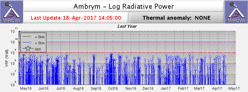 |
Figure 36. Plot of MODIS thermal infrared data analyzed by MIROVA showing log radiative power for Ambrym for the year ending 18 April 2017. Courtesy of MIROVA. |
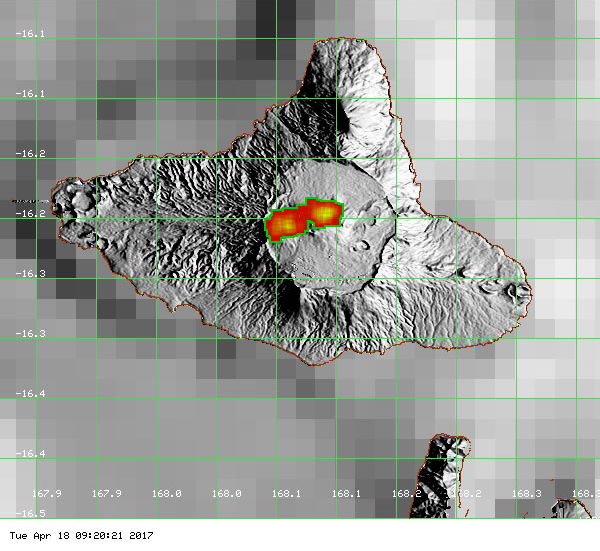 |
Figure 37. MODVOLC thermal alerts measured during mid-January to mid-April 2017, as an example of similar densities of thermal alerts since about 2009. More than approximately 160 thermal alert pixels (red/orange squares) for this 3-month period are centered over the Marum and Benbow craters. Courtesy of (HIGP), MODVOLC Thermal Alerts System. |
Geological Summary. Ambrym, a large basaltic volcano with a 12-km-wide caldera, is one of the most active volcanoes of the New Hebrides Arc. A thick, almost exclusively pyroclastic sequence, initially dacitic then basaltic, overlies lava flows of a pre-caldera shield volcano. The caldera was formed during a major Plinian eruption with dacitic pyroclastic flows about 1,900 years ago. Post-caldera eruptions, primarily from Marum and Benbow cones, have partially filled the caldera floor and produced lava flows that ponded on the floor or overflowed through gaps in the caldera rim. Post-caldera eruptions have also formed a series of scoria cones and maars along a fissure system oriented ENE-WSW. Eruptions have apparently occurred almost yearly during historical time from cones within the caldera or from flank vents. However, from 1850 to 1950, reporting was mostly limited to extra-caldera eruptions that would have affected local populations.
Information Contacts: Vanuatu Geohazards Observatory (VGO), Geo-Hazards office, Vanuatu Meteorology and Geo-Hazards Department (URL: http://www.vmgd.gov.vu/vmgd/); Wellington Volcanic Ash Advisory Centre (VAAC), Meteorological Service of New Zealand Ltd (MetService), PO Box 722, Wellington, New Zealand (URL: http://vaac.metservice.com/); Hawai'i Institute of Geophysics and Planetology (HIGP), MODVOLC Thermal Alerts System, School of Ocean and Earth Science and Technology (SOEST), Univ. of Hawai'i, 2525 Correa Road, Honolulu, HI 96822, USA (URL: http://modis.higp.hawaii.edu/); MIROVA (Middle InfraRed Observation of Volcanic Activity), a collaborative project between the Universities of Turin and Florence (Italy) supported by the Centre for Volcanic Risk of the Italian Civil Protection Department (URL: http://www.mirovaweb.it/); Stromboli Online (URL: http://www.swisseduc.ch/stromboli/perm/van/links-en.html).